Wednesday, January 21 Morning Report
The coldest air of this stretch is with us this morning, but the wind has eased. Today we begin a warm-up, and it will be mild NEARING 50°F tomorrow. The next arctic surge will arrive for the weekend, then all eyes will be on the winter storm.
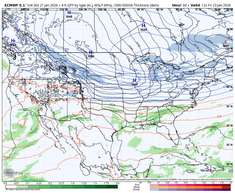
What I am about to show you is the reason I DO NOT show snow totals too soon. The Canadian Model’s suggestion of a stronger Low Pressure has been shown with the new European Model. This will pull the track farther north and introduce more icy mix into Maryland.
Yes, I still see bitter cold and heavy snow arriving LATE Saturday Night into Sunday morning. Then sleet and freezing rain in the afternoon is very possible while temps stay in the 20s. That would have a definite impact in significance of snow accumulation AND add to the messy clean up.
WEEKEND WINTER STORM IMPACT
Here is the likely effect across the US between Friday and Sunday.
A large area will be affected, with an ice storm to the south and heavy snow that may mix with ice across the Mid-Atlantic.
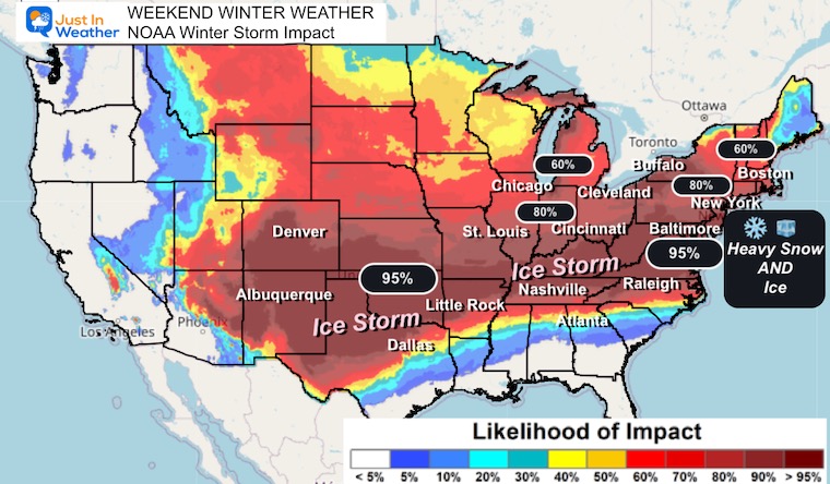
Temps are expected to remain below freezing, so there is a realistic remaining impact on schools and work into Monday after the storm departs.
Temperatures are expected to remain below freezing at least into the middle of next week, and there is more arctic air on the way to follow.
Let’s take a look…
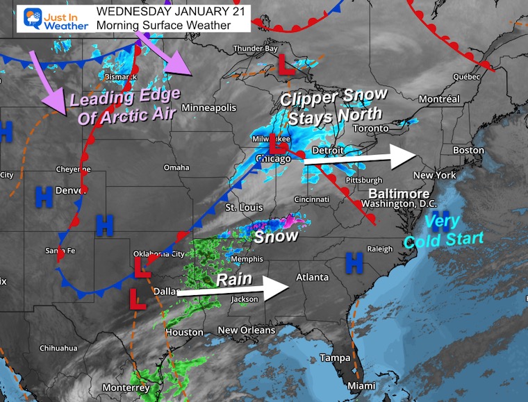
Morning Surface Weather
For Baltimore and the Mid-Atlantic: A very cold start this morning, but relief is on the way! Temperatures will moderate today as high pressure shifts east. Dry and not as cold with highs near 40°F.
- Clipper Snow Stays North: A clipper system is tracking across the Great Lakes from Wisconsin through Michigan and into southern Canada. This will stay north of our region, bringing snow to areas along and north of I-90.
- Snow & Rain Developing South: Watch the Southern Plains! Snow is falling over Oklahoma and Arkansas, with rain across Texas and Louisiana. This is the energy that will eventually feed into our weekend winter storm.
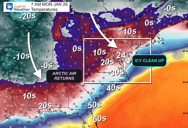
- Leading Edge of Arctic Air: The next surge of arctic air is building across the northern Rockies and Dakotas. This cold air will be vital for the weekend storm — arriving Saturday to set the stage for snow and ice.
- Weekend Storm Setup: The southern energy (rain/snow) will eject northeast and phase with the arctic air, forming our major winter storm for Sunday.
Local Look
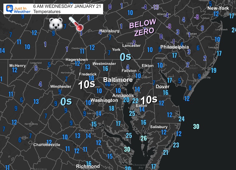
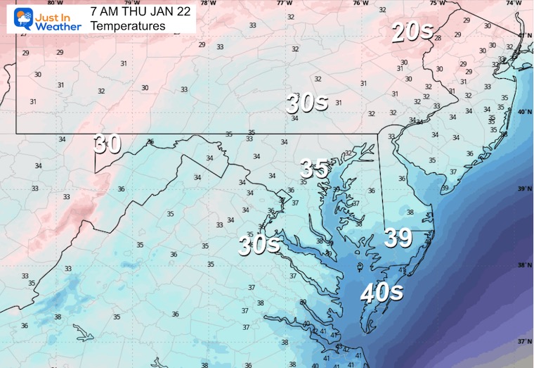
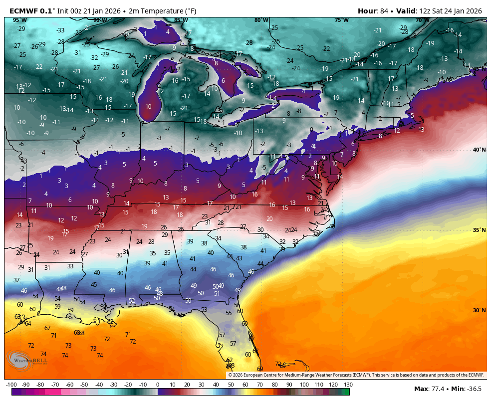
Morning Temperatures
- Below Zero in Northeast PA and the Lehigh Valley.
- Single Digits across the Northern Suburbs and Piedmont.
- Low to mid-teens in most other areas.
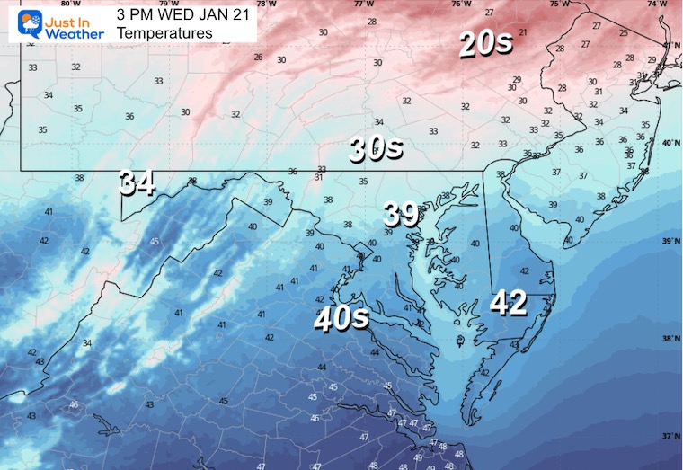
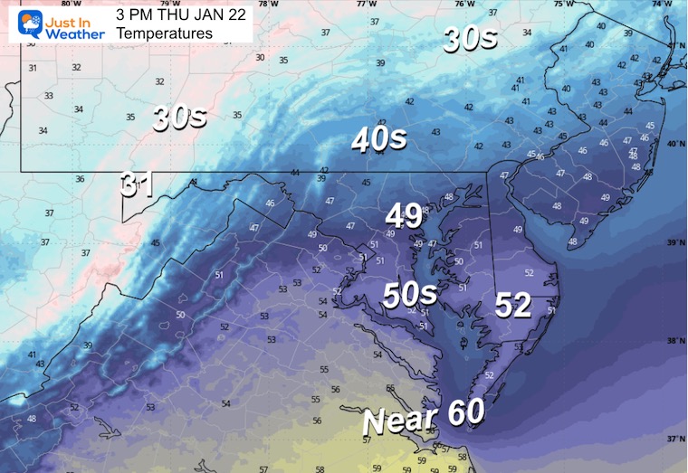
Afternoon Temperatures
MOUNTAIN CAM:
WESTERN MARYLAND
This webcam is positioned at The Greene Turtle Deep Creek Lake and shows Wisp Resort, including a zoomed-in view of Squirrel Cage, The Face, the terrain park, Boulder, the mountain coaster, the tubing park and a shot of McHenry Cove at Deep Creek Lake!
CLIMATE DATA: Baltimore
Yesterday: Low 14°F; High 29°F
Precipitation: 0.00″
Season Snow Total: 2.4″
Snow Depth: 0″
Top Wind Gust: 33 mph
TODAY January 21
Sunrise at 7:22 AM
Sunset at 5:15 PM
Normal Low in Baltimore: 25ºF
Record Low: -6ºF in 1985
Normal High in Baltimore: 43ºF
Record High: 66ºF in 1921
Rainfall Deficit at BWI
- Prior 2 Years (2024 + 2025) = -16.91″
- Since Jan 1, 2026 = -0.89″
In Case You Missed This
THURSDAY
This will be the calmest and warmest day of the week.
Morning Temperatures
Afternoon Temperatures
Storm Forecast Friday To Monday
SUGGESTION: ECMWF Model
This development of the storm will be with the Phasing of the Northern and Southern branches of the Jet Stream. That STRONGER Low Pressure will pull warmer air farther North, at cloud level.
This is what is expected to bring that icy mix into Maryland.
CLOSER LOOK
Temperatures
I want to start with this to show that the freezing air AT THE SURFACE will remain below freezing for our region. Cold Arctic air will move in before the storm, clash with it as the storm passes, and then return once the system moves out.
Saturday Morning
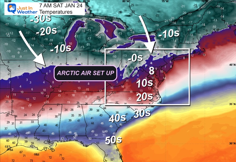
Forecast Saturday Morning to Monday Morning
This shows the attempt of warmer air to push northward. While surface temperatures remain below freezing, the air at cloud level will be warmer; that is where the icy mix gets introduced.
SNAPSHOTS
Sunday Morning
Low to mid-teens in Baltimore with heavy snow!
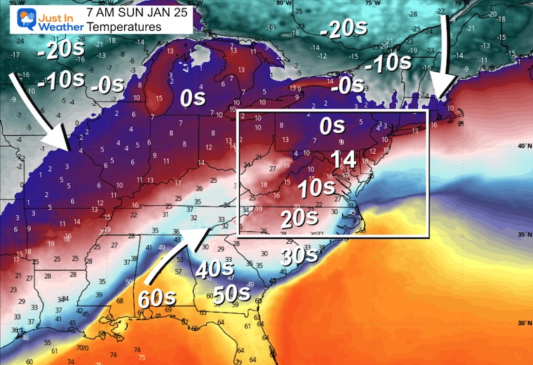
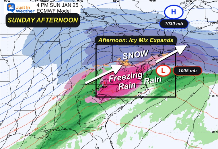
Sunday Afternoon
Lower 20s in Baltimore, but temperatures at cloud level will be warmer. This is where the sleet and freezing rain may come into play for many areas. Some inland spots will remain all snow and get dumped on!
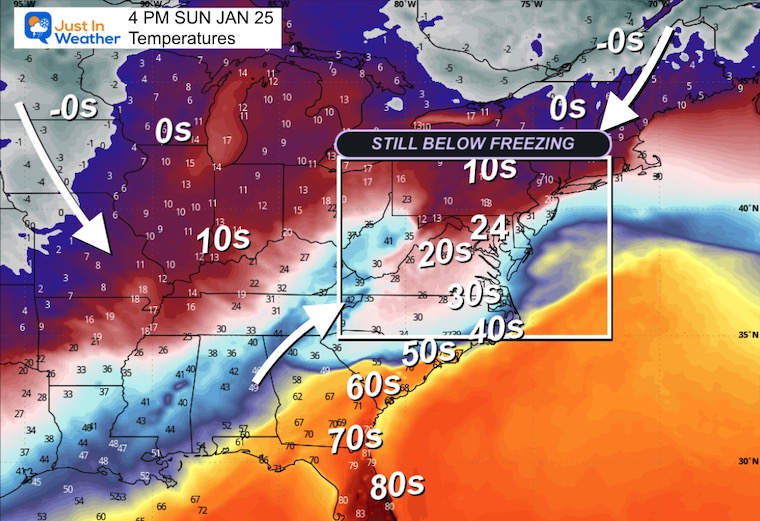
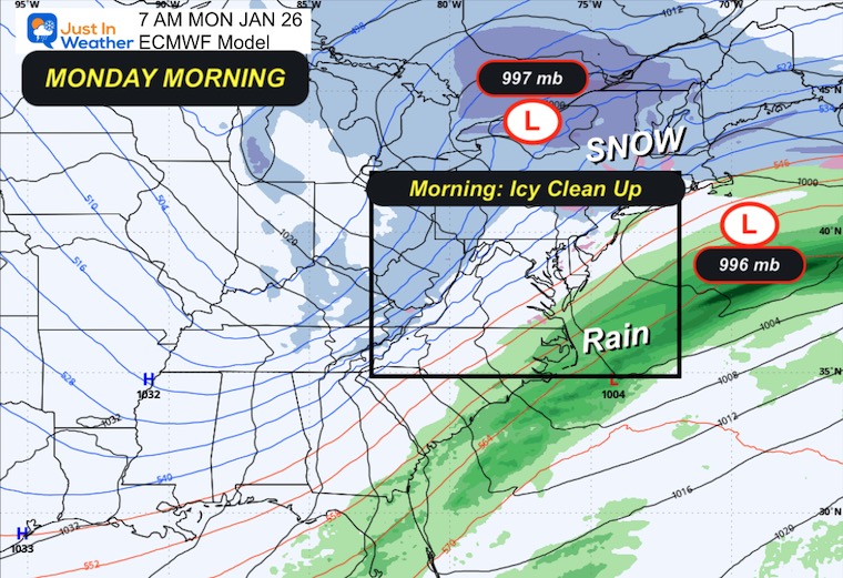
Monday Morning
Remaining below freezing for the post-storm clean-up.
STORM SET UP
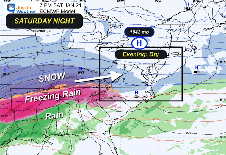
Saturday Night
Arctic High will be in place as the leading edge of snow approaches from the Ohio Valley. The cold and dry air will be a challenge for the onset of flakes to reach the ground.
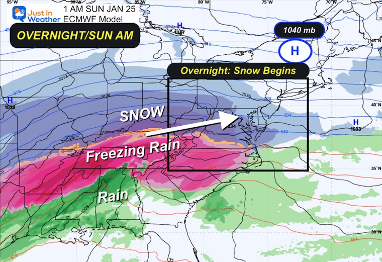
1 AM Sunday
I expect a wide range between 10 PM and 3 AM for our snow to begin across the region.
The snow will expand overnight and be with us on Sunday Morning.
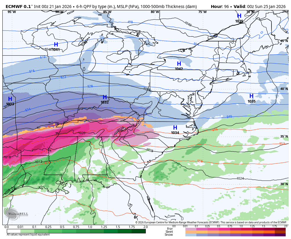
Heavy snow and a true ice storm are expected across the South!
Storm Forecast: Saturday Night to Monday Morning
This is important: A stronger Low Pressure, as originally shown by the Canadian GEM Model, will pull farther north. This allows warmer air at cloud level as well to bring a mix of sleet and freezing rain.
Temps remain below freezing, making for a long-duration event that will also take a long time to clean up on Monday after it ends.
SNAPSHOTS
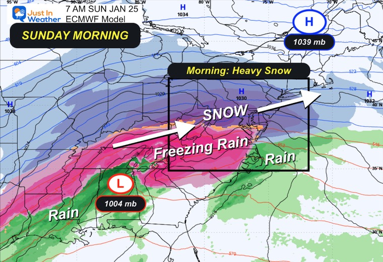
Sunday Morning
Heavy Snow with temps in the teens!!!
Watching that icy mix expand through Virginia and likely to keep moving north into Maryland.
 ‘
‘
Sunday Afternoon
That icy mix seen here very close to I-95. That is an historical setup. This is one of the fine details that will be in better focus as we get closer.
Plan for heavy snow and ice through the afternoon and night.
Monday Morning
The storm will pull away, and temperatures remain below freezing. Upper-level energy may keep flurries and snow showers in the mix through the afternoon.
Looking Ahead:
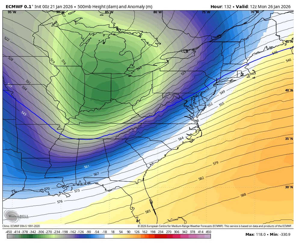
Jet Stream Through January 31
Another surge of Arctic Air will arrive, and this may also include the potential for additional snow.
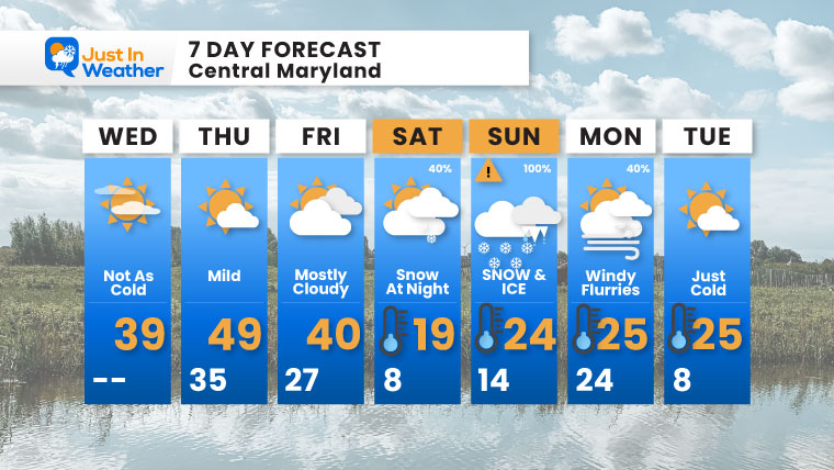
7-Day Forecast
Enjoy the mild break Wednesday-Thursday (near 50°F!), then arctic air crashes back on Saturday with snow starting at night.
Sunday is the main event: 100% chance of SNOW & ICE!
Those frigid temperatures (lows in single digits, highs in the teens and 20s) mean everything that falls will stick.
Faith In The Flakes!
- Wednesday: Not as cold. High 39°F.
- Thursday: Mild. High 49°F, Low 35°F.
- Friday: Mostly cloudy. High 40°F, Low 27°F.
- Saturday: Snow at night (40%). High 19°F, Low 8°F.
- Sunday: SNOW & ICE (100%). High 24°F, Low 14°F.
- Monday: Windy with flurries (40%). High 25°F, Low 24°F.
- Tuesday: Just cold. High 25°F, Low 8°F.
Subscribe for email Alerts
FAITH IN THE FLAKES STORE
NOW OPEN FOR THE SEASON
click here

Snow Report December 14 and Grade My Forecast
In case you missed it, click this image for brief summary of the final snow totals from the last event.

Snow Report December 5 to 6 and Grade My Forecast
In case you missed it, click this image for brief summary of the final snow totals from the last event.

My Winter Outlook For Above-Average Snow
Click here for the full report

La Niña Advisory
This was issued October 9, as expected: A weak and short-lived event to start winter may play a different role this winter.

In Case You Missed It
Woolly Bear Caterpillar Winter Folklore
These are NOT all the same caterpillar!

Winter Outlook From 2 Farmers’ Almanacs

STEM Assemblies/In School Fields Trips Are Back
Click to see more and ‘Book’ a visit to your school

THANK YOU:
Baltimore Sun Magazine Readers’ Choice Best Of Baltimore

Maryland Trek 12 Day 7 Completed Sat August 9
UPDATED: We raised OVER $170,000 for Just In Power Kids – AND Still Collecting More
The annual event: Hiking and biking 329 miles in 7 days between The Summit of Wisp to Ocean City.
Each day, we honor a kid and their family’s cancer journey.
Fundraising is for Just In Power Kids: Funding Free Holistic Programs. I never have and never will take a penny. It is all for our nonprofit to operate.
Click here or the image to donate:

RESTATING MY MESSAGE ABOUT DYSLEXIA
I am aware there are some spelling and grammar typos and occasional other glitches. I take responsibility for my mistakes and even the computer glitches I may miss. I have made a few public statements over the years, but if you are new here, you may have missed it: I have dyslexia and found out during my second year at Cornell University. It didn’t stop me from getting my meteorology degree and being the first to get the AMS CBM in the Baltimore/Washington region. One of my professors told me that I had made it that far without knowing and to not let it be a crutch going forward. That was Mark Wysocki, and he was absolutely correct! I do miss my mistakes in my own proofreading. The autocorrect spell check on my computer sometimes does an injustice to make it worse. I can also make mistakes in forecasting. No one is perfect at predicting the future. All of the maps and information are accurate. The ‘wordy’ stuff can get sticky. There has been no editor who can check my work while writing and to have it ready to send out in a newsworthy timeline. Barbara Werner is a member of the web team that helps me maintain this site. She has taken it upon herself to edit typos when she is available. That could be AFTER you read this. I accept this and perhaps proves what you read is really from me… It’s part of my charm. #FITF
Please share your thoughts and best weather pics/videos, or just keep in touch via social media.


