Tuesday, January 20 Morning Report
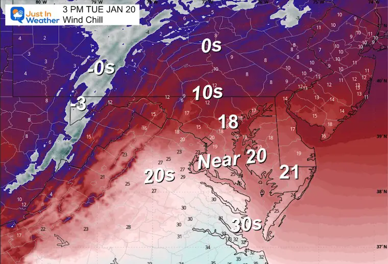
The immediate weather story is all about cold winds! Temps stay below freezing, and wind chills will widely stay in the single digits and teens.
Large High Pressure will bring us a few sunny and mild days to follow, then we turn our attention to a large winter storm this weekend.
I have high confidence in this event impacting us, BUT I am also hesitant to jump on snow totals. It would be easy to do that and rank up the attention with the hype. I believe the timing is becoming more focused on Sunday into Monday, which is what teachers and kids may like for affects on schools. The specific track and totals will still fluctuate on modeling as various parts need to be coordinated to determine how far the Arctic air will lock in. That will lock in the north edge of snow and banding heavy snow, plus the ice storm that will inevitably be a major story for parts of the Southern US and may get close to some in our region as well.
Cold air will remain, while the activity could result in more storms over the next 2 to 3 weeks.
Local Look
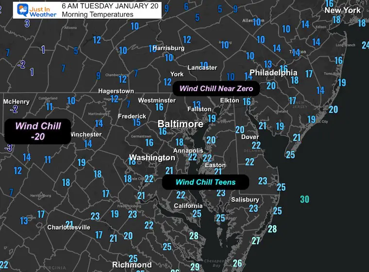
Morning Temperatures
Wider View
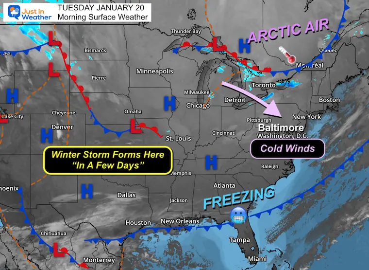
Morning Surface Weather
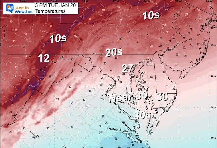
For Baltimore and the Mid-Atlantic: Cold winds are the story today! Arctic air has settled in with temperatures staying below freezing and wind chills in the single digits and teens. Highs will only reach the upper 20s.
- Arctic Air: A large arctic air mass stretches from Canada through the Great Lakes and into the Mid-Atlantic. This is the core of the cold; today will be the coldest day of this stretch.
- Freezing South: The cold has pushed all the way to the Gulf Coast, with freezing temperatures extending into Florida. This sets the stage for the weekend storm.
- High Pressure Dominance: Strong high pressure over the central U.S. will bring us a few sunny, milder days Wednesday through Thursday before the next storm arrives.
- Winter Storm Forms Here “In A Few Days”: Watch the Southwest! Energy moving into the Four Corners region will eject into the Southern Plains later this week. This is where our weekend winter storm will develop, tracking northeast and potentially bringing significant snow to our region Sunday into Monday.
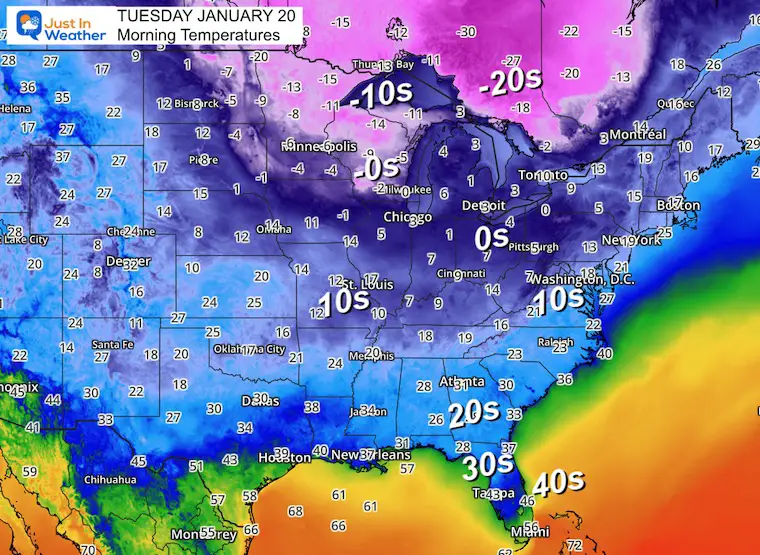
Morning Temperatures
The Deep Freeze has reached down into Florida.
Below Zero across the Northern US and Canada is still a major source of breeding for our next push of arctic air later this week.
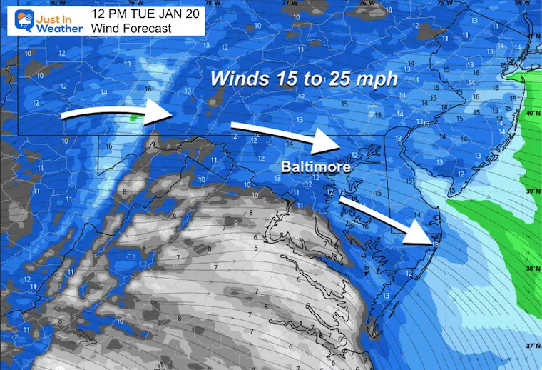
Wind Forecast
Just enough wind to make the cold air feel colder!
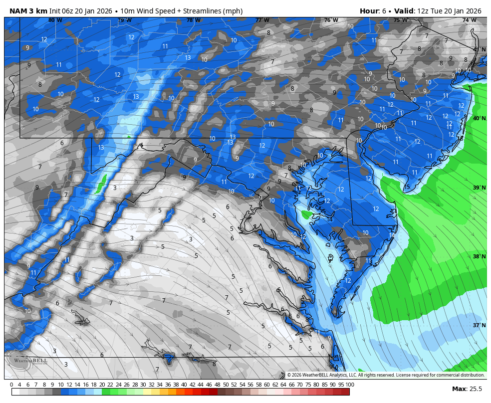
Mid-Day Winds
Gusts to 25 mph, just enough to make our cold temperatures feel even colder.
Afternoon Temperatures
Afternoon Wind Chills
MOUNTAIN CAM:
WESTERN MARYLAND
This webcam is positioned at The Greene Turtle Deep Creek Lake and shows Wisp Resort, including a zoomed-in view of Squirrel Cage, The Face, the terrain park, Boulder, the mountain coaster, the tubing park and a shot of McHenry Cove at Deep Creek Lake!
CLIMATE DATA: Baltimore
Yesterday: Low 17°F; High 41°F
Precipitation: 0.00″
Season Snow Total: 2.4″
Snow Depth: 0″
Top Wind Gust: 26 mph
TODAY January 20
Sunrise at 7:22 AM
Sunset at 5:14 PM
Normal Low in Baltimore: 25ºF
Record Low: -3ºF in 1985
Normal High in Baltimore: 43ºF
Record High: 71ºF in 1951
Rainfall Deficit at BWI
- Prior 2 Years (2024 + 2025) = -16.91″
- Since Jan 1, 2026 = -0.80″
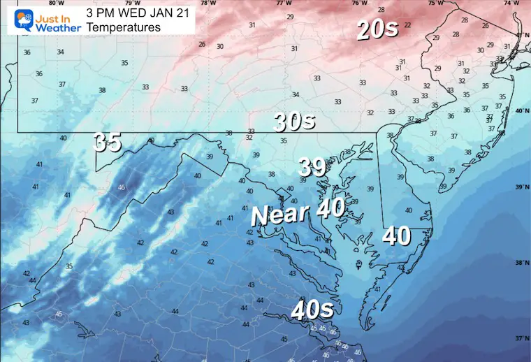
WEDNESDAY
The new arctic air mass will be undeniable as the temperatures remain in the freeze all day. Wind chills will be very noticeable.
Morning Temperatures

Afternoon Temperatures
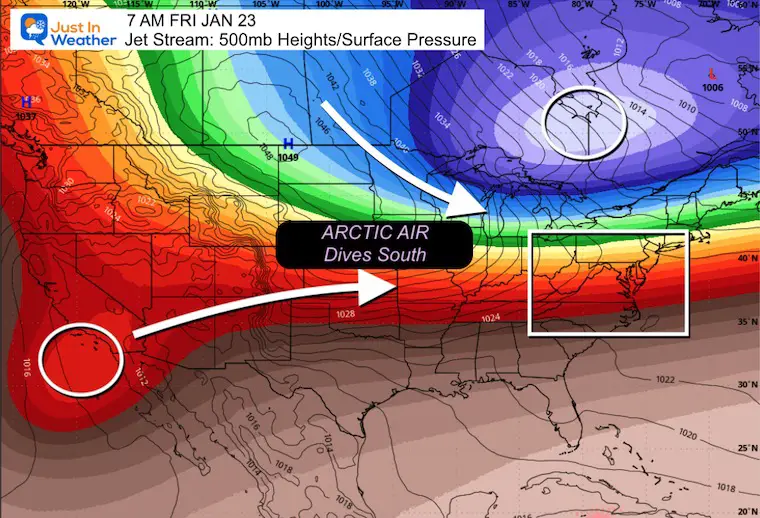
LOOKING AHEAD: FRIDAY
Jet Stream 500mb (18,000 Ft) Forecast with Sea Level Pressure as forecast by the ECWMF AI Forecast System:
The highlight here is the expected Phasing of the two breaches of the jet stream.
Arctic Air in Canada will be dropping southward, enhancing the baroclinic air zone.
Moisture from Low Pressure off Southern California will be ejected into the Central US and phase to develop a large region with snow and freezing rain.
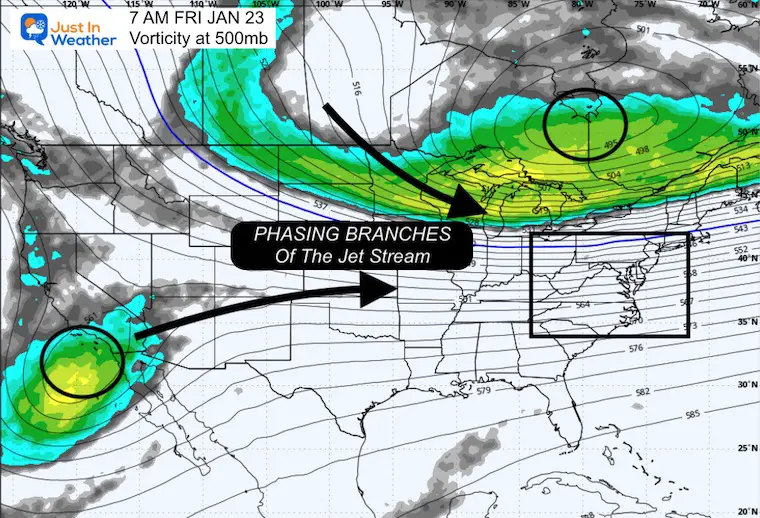
Jet Steam Vorticity at 500mb:
This is a measure of cycling or spin that enhances unstable air below. This is what helps the formation of clouds and precipitation.
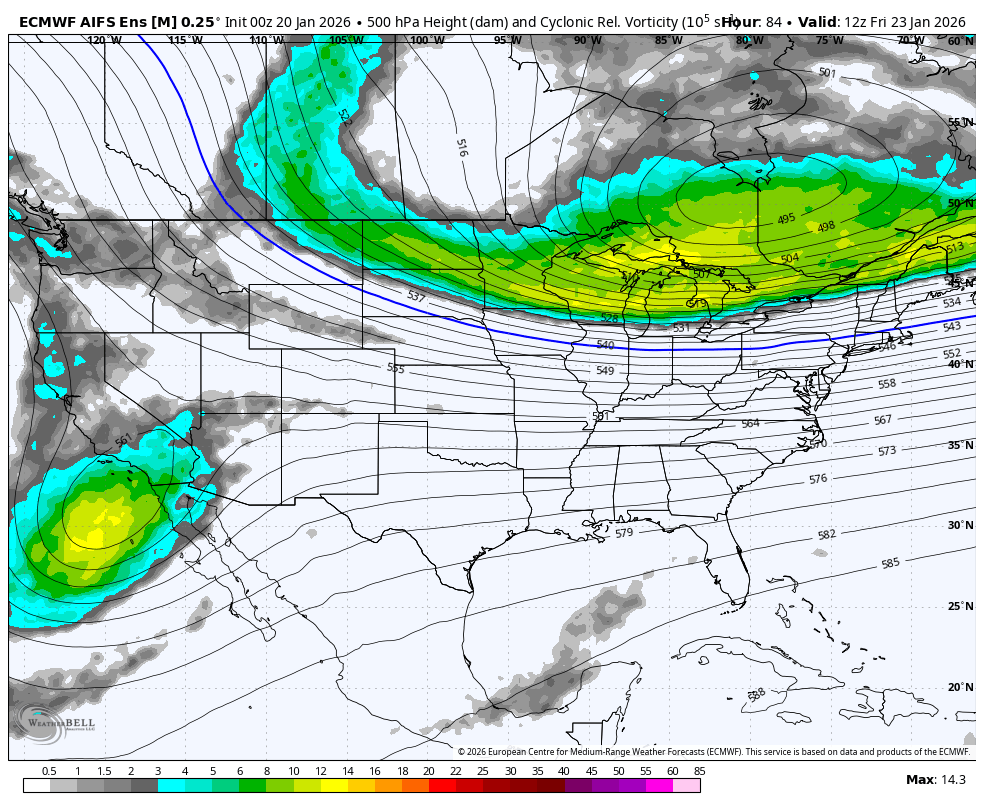
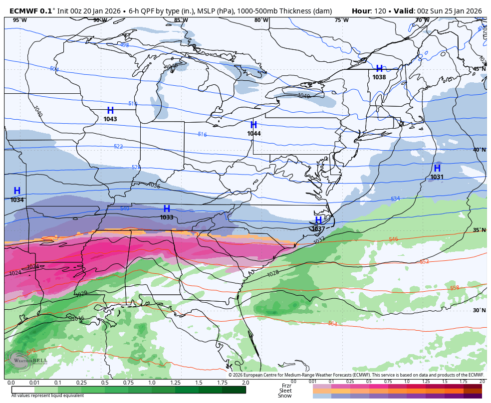
Storm Forecast Friday To Sunday
SUGGESTION: ECMWF Model
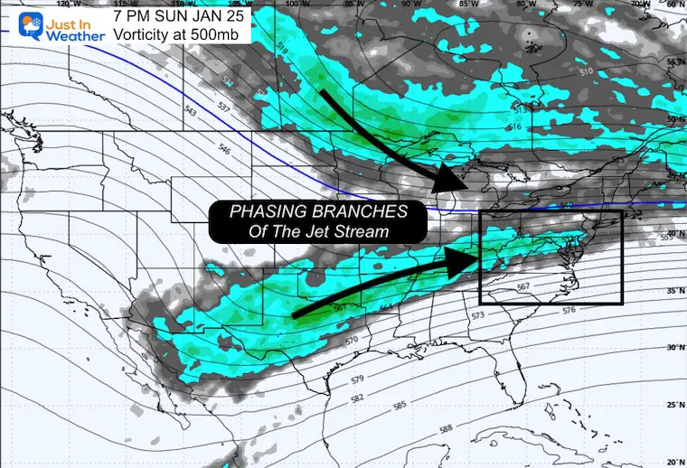
Sunday Night Forecast
Phasing or merging of the energy is what will develop this broad area of snow and freezing rain. The location of the arctic air and high pressure is still the main driver of where this will set up to track.
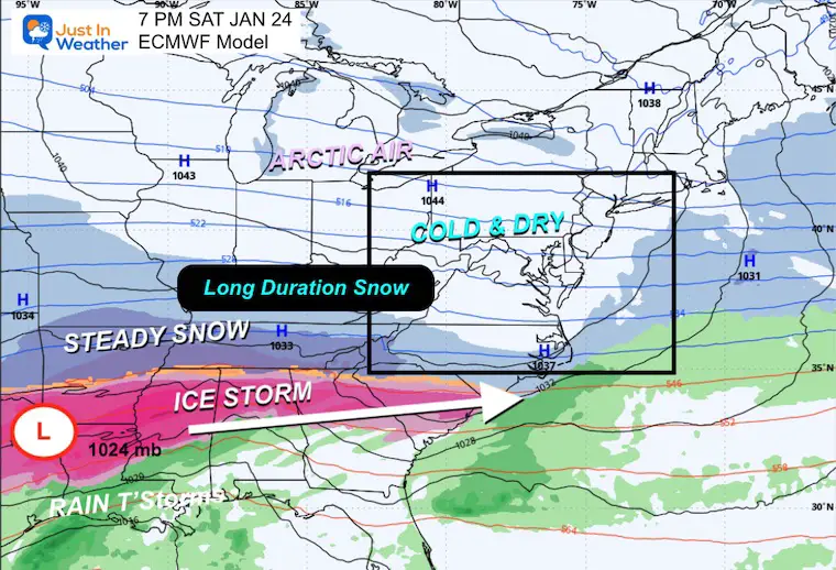
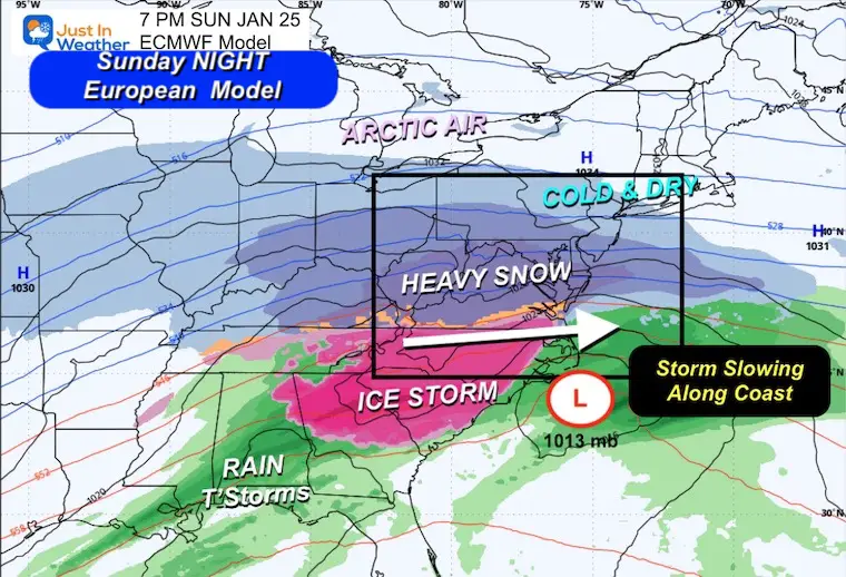
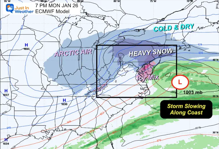
Storm Forecast:
Saturday Night to Monday Night
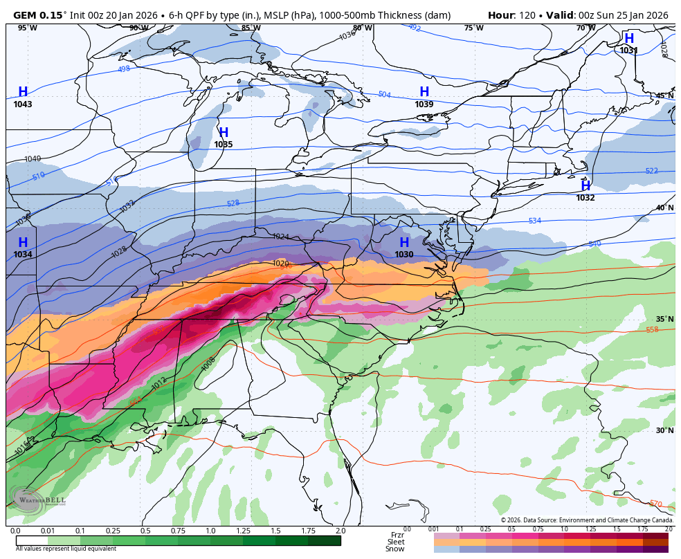
This is the expected development and track as seen by the European ECMWF Model. This has led the charge. The timing has been pushed a little later to arrive AND track has shifted a little farther north.
SNAPSHOTS
Saturday Night
Sunday Night
Monday Night
Canadian GEM Model Forecast: Saturday Night to Monday Night
This is important: This model performs best in arctic patterns. Here, it has the timing about 12 hours earlier AND shows a very distinct father north push of the icy mix. THIS is why I am holding off on snow totals for now.
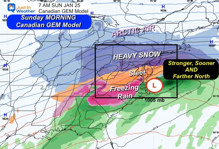
Sunday Morning Snapshot
This model has the storm Stronger but sooner! Also, Farther North! That brings icy mix into Maryland and could cut down on potential totals.
Looking Ahead:
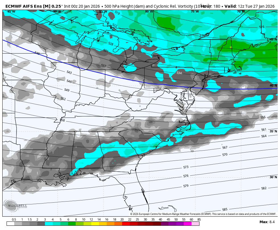
Vorticity Forecast To Thursday
There may be a clipper-like system to bring additional snow (chance) later next week.
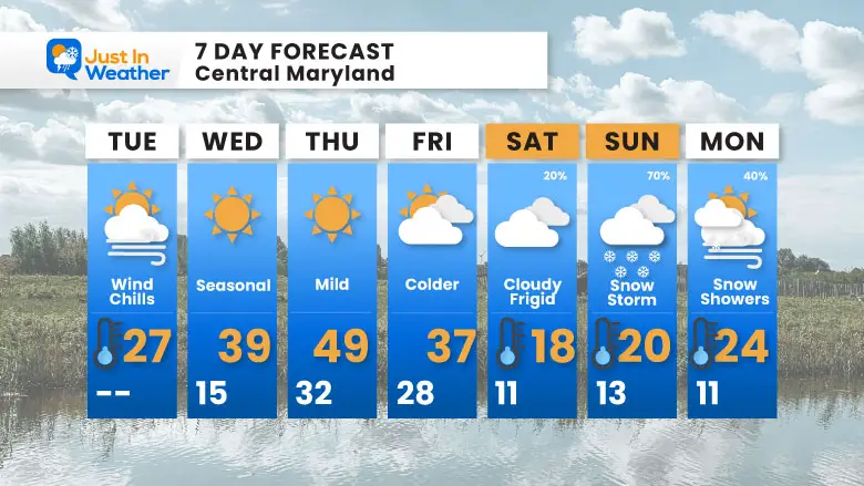
7-Day Forecast
After a brief warm-up Thursday (near 50°F!), arctic air crashes back in. Saturday is frigid with highs only 18°F, then the Snow Storm arrives on Sunday with 70% chance! Those cold temperatures mean whatever falls will stick.
Faith In The Flakes!
- Tuesday: Wind chills. High 27°F
- Wednesday: Seasonal. High 39°F, Low 15°F
- Thursday: Mild. High 49°F, Low 32°F
- Friday: Colder. High 37°F, Low 28°F
- Saturday: Cloudy and frigid (20%). High 18°F, Low 11°F
- Sunday: Snow Storm (70%). High 20°F, Low 13°F
- Monday: Snow showers (40%). High 24°F, Low 11°F
Subscribe for email Alerts
FAITH IN THE FLAKES STORE
NOW OPEN FOR THE SEASON
click here

Snow Report December 14 and Grade My Forecast
In case you missed it, click this image for brief summary of the final snow totals from the last event.

Snow Report December 5 to 6 and Grade My Forecast
In case you missed it, click this image for brief summary of the final snow totals from the last event.

My Winter Outlook For Above-Average Snow
Click here for the full report

La Niña Advisory
This was issued October 9, as expected: A weak and short-lived event to start winter may play a different role this winter.

In Case You Missed It
Woolly Bear Caterpillar Winter Folklore
These are NOT all the same caterpillar!

Winter Outlook From 2 Farmers’ Almanacs

STEM Assemblies/In School Fields Trips Are Back
Click to see more and ‘Book’ a visit to your school

THANK YOU:
Baltimore Sun Magazine Readers’ Choice Best Of Baltimore

Maryland Trek 12 Day 7 Completed Sat August 9
UPDATED: We raised OVER $170,000 for Just In Power Kids – AND Still Collecting More
The annual event: Hiking and biking 329 miles in 7 days between The Summit of Wisp to Ocean City.
Each day, we honor a kid and their family’s cancer journey.
Fundraising is for Just In Power Kids: Funding Free Holistic Programs. I never have and never will take a penny. It is all for our nonprofit to operate.
Click here or the image to donate:

RESTATING MY MESSAGE ABOUT DYSLEXIA
I am aware there are some spelling and grammar typos and occasional other glitches. I take responsibility for my mistakes and even the computer glitches I may miss. I have made a few public statements over the years, but if you are new here, you may have missed it: I have dyslexia and found out during my second year at Cornell University. It didn’t stop me from getting my meteorology degree and being the first to get the AMS CBM in the Baltimore/Washington region. One of my professors told me that I had made it that far without knowing and to not let it be a crutch going forward. That was Mark Wysocki, and he was absolutely correct! I do miss my mistakes in my own proofreading. The autocorrect spell check on my computer sometimes does an injustice to make it worse. I can also make mistakes in forecasting. No one is perfect at predicting the future. All of the maps and information are accurate. The ‘wordy’ stuff can get sticky. There has been no editor who can check my work while writing and to have it ready to send out in a newsworthy timeline. Barbara Werner is a member of the web team that helps me maintain this site. She has taken it upon herself to edit typos when she is available. That could be AFTER you read this. I accept this and perhaps proves what you read is really from me… It’s part of my charm. #FITF
Please share your thoughts and best weather pics/videos, or just keep in touch via social media.


