


Winter Weather Advisory Sunday As Snowfall In Two Parts Affecting Two Different Areas
Saturday Evening Update January 17 2026 One thing I carry after all of my years of forecasting: If one model does a really good job in an active pattern, then…
Monday January 19, Morning Report
We got measurable snow yesterday — 0.2″! Seasonal total is now up to 2.4″. The evening part of the snow did bring a range of 1/2” to 1 inch across the region, but the reports have been limited. What matters is that what was melted, most likely refroze.
The little bit of snow made for big problems in the evening as temperatures dropped and roads iced over. Any place not treated will be icy this morning.
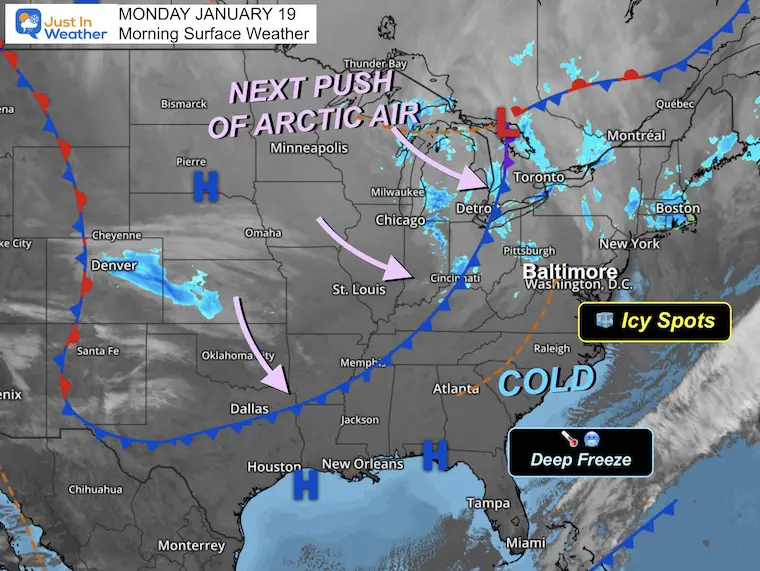
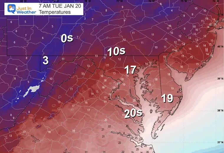
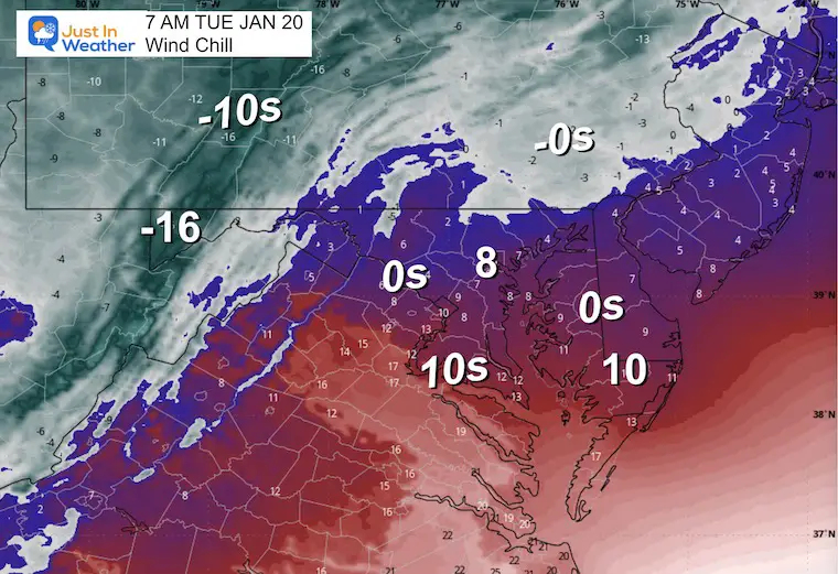
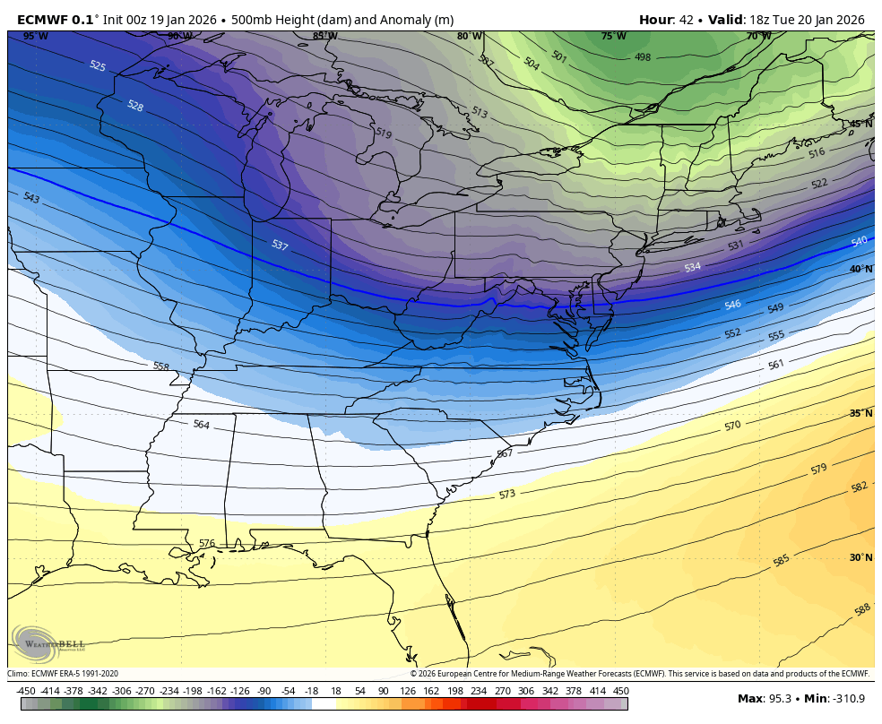
The core of this air mass will arrive on Tuesday, then relax for a few days.
The next arctic air mass arrives ahead of a larger storm for the weekend. There is a high chance of snow, but the specifics still need refinement.
I have seen the models vary with timing and track, so the totals of snow potential would be purely a guess at this point.
The best suggestion I want to make is keep the likelihood of snow in your planning for both days next weekend.
The overall pattern looks to hold the cold through the end of the month.
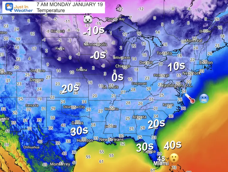
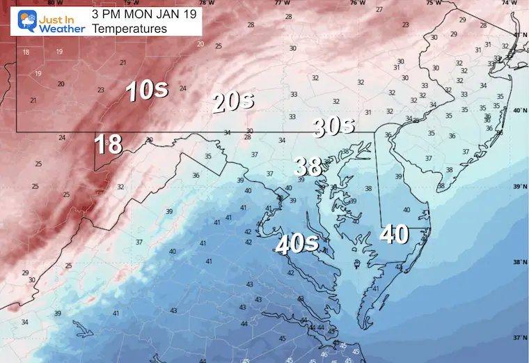
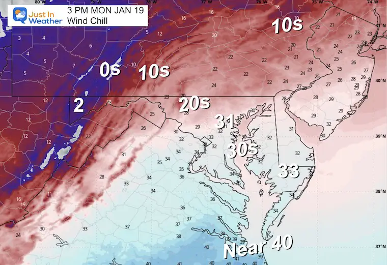
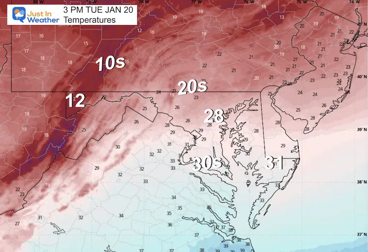
Most of the region is in the 10s to lower 20s!
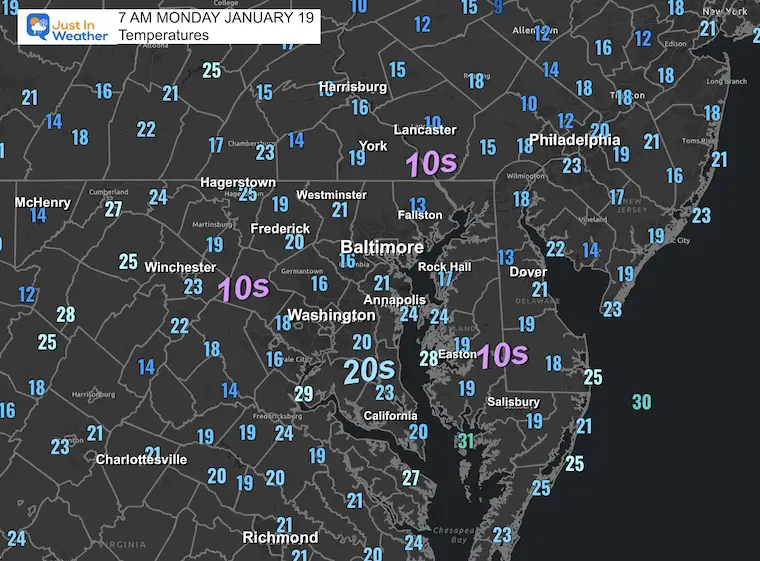
For Baltimore and the Mid-Atlantic: A chilly start to MLK Day with icy spots possible this morning from yesterday’s snow and melting, which froze last night!
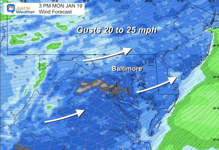
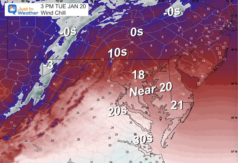
Just enough wind to make the cold air feel colder!
WESTERN MARYLAND
This webcam is positioned at The Greene Turtle Deep Creek Lake and shows Wisp Resort, including a zoomed-in view of Squirrel Cage, The Face, the terrain park, Boulder, the mountain coaster, the tubing park and a shot of McHenry Cove at Deep Creek Lake!
Yesterday: Low 21°F; High 36°F
Precipitation: 0.13″
Season Snow Total: 2.4”; Sunday Snow Added 0.2”
Snow Depth: 0″
Top Wind Gust: 21 mph
Sunrise at 7:23 AM
Sunset at 5:13 PM
Normal Low in Baltimore: 25ºF
Record Low: -5ºF in 1994
Normal High in Baltimore: 43ºF
Record High: 69ºF in 1951
Rainfall Deficit at BWI
The new arctic air mass will be undeniable as the temperatures remain in the freeze all day. Wind chills will be very noticeable.
This wave of Arctic Air will be brief, and a mild surge later in the week will be comfortable. It may also be deceiving.
The next wave of Arctic Air will be Stronger AND Longer Lasting. This is also what may help develop a larger winter storm across the Southern US and affect us next weekend.
I was kidding and serious with this post last night. The model is still CHANGING the track and timing as you compare below.
I must emphasize that while I absolutely believe we will get a broad area of impactful winter weather, the specifics are still fuzzy. This model animation shows the southern track system tap our region with snow Saturday into Sunday.
NOTE: This model has changed its look for the event with each run. The plot for the story location AND timing has shifted. So I am still hesitant to push specifics. Just keep the notion of accumulating snow next weekend with your plans.

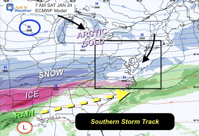
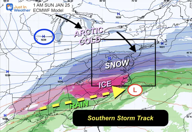
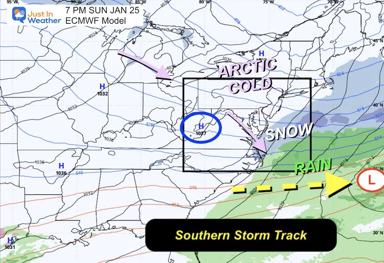
The first of two waves of Arctic Air will arrive on Tuesday and will be brief. The second wave will be ahead of the POTENTIAL winter storm over the weekend. That will most surely be subject to refining the details. Just keep that weekend window on your mind with plans ahead.
Faith In The Flakes!
Subscribe for email Alerts
Sign up and be the first to know!

In case you missed it, click this image for brief summary of the final snow totals from the last event.

In case you missed it, click this image for brief summary of the final snow totals from the last event.

Click here for the full report

This was issued October 9, as expected: A weak and short-lived event to start winter may play a different role this winter.

These are NOT all the same caterpillar!


Click to see more and ‘Book’ a visit to your school


The annual event: Hiking and biking 329 miles in 7 days between The Summit of Wisp to Ocean City.
Each day, we honor a kid and their family’s cancer journey.
Fundraising is for Just In Power Kids: Funding Free Holistic Programs. I never have and never will take a penny. It is all for our nonprofit to operate.
Click here or the image to donate:

I am aware there are some spelling and grammar typos and occasional other glitches. I take responsibility for my mistakes and even the computer glitches I may miss. I have made a few public statements over the years, but if you are new here, you may have missed it: I have dyslexia and found out during my second year at Cornell University. It didn’t stop me from getting my meteorology degree and being the first to get the AMS CBM in the Baltimore/Washington region. One of my professors told me that I had made it that far without knowing and to not let it be a crutch going forward. That was Mark Wysocki, and he was absolutely correct! I do miss my mistakes in my own proofreading. The autocorrect spell check on my computer sometimes does an injustice to make it worse. I can also make mistakes in forecasting. No one is perfect at predicting the future. All of the maps and information are accurate. The ‘wordy’ stuff can get sticky. There has been no editor who can check my work while writing and to have it ready to send out in a newsworthy timeline. Barbara Werner is a member of the web team that helps me maintain this site. She has taken it upon herself to edit typos when she is available. That could be AFTER you read this. I accept this and perhaps proves what you read is really from me… It’s part of my charm. #FITF