


January 16 A Chance For Light Snow This Weekend In Different Parts Of Our Region Each Day
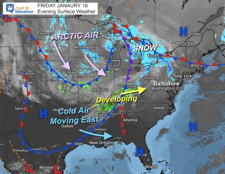
Friday January 16 There is a lot to talk about this morning in all directions. The deep freeze has reached Florida, with parts of it in the 20s and snow…
Friday Evening Update January 16 2026
Two weather events will bring snow to our region this weekend. They are related to the fast winds aloft on the edge of this arctic air mass. These will not affect our region equally, and I hope this can simplify the breakdown.
System One On Saturday: In response to a jet streak, fast level winds high in the atmosphere, a band of snow will develop after midnight through the morning. This will affect inland areas along the front ridge of the mountain and inland hilly suburbs with some accumulating snow.
Timing is key for areas that may barely hold in the cold below freezing.
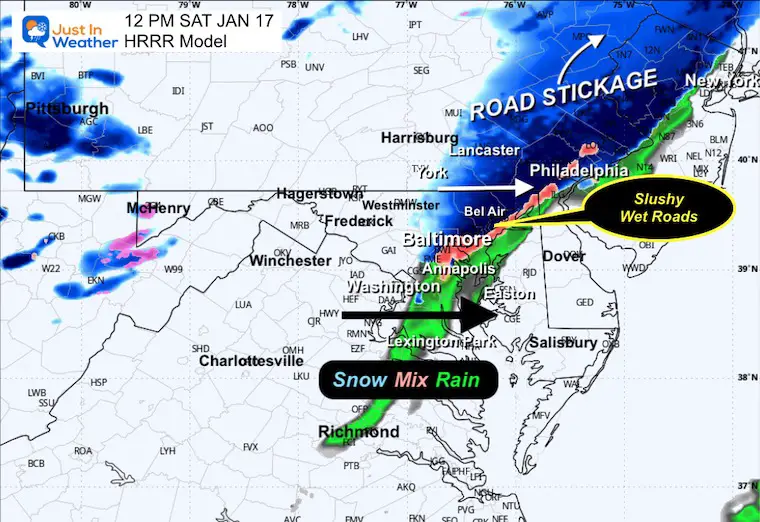
As this system moves into Central Maryland and metro areas around Washington and Baltimore, the marginal temperatures will eventually lead to slushy mix and then rain.
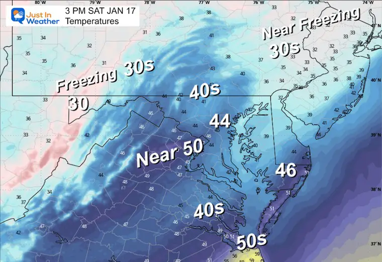
The dilemma is how cold the ground temps remain after this recent chill. Temps will be warming during the day and reach the 40s Saturday afternoon.
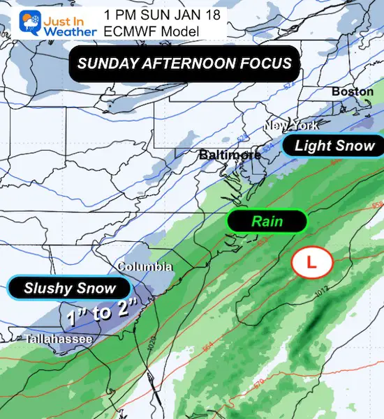
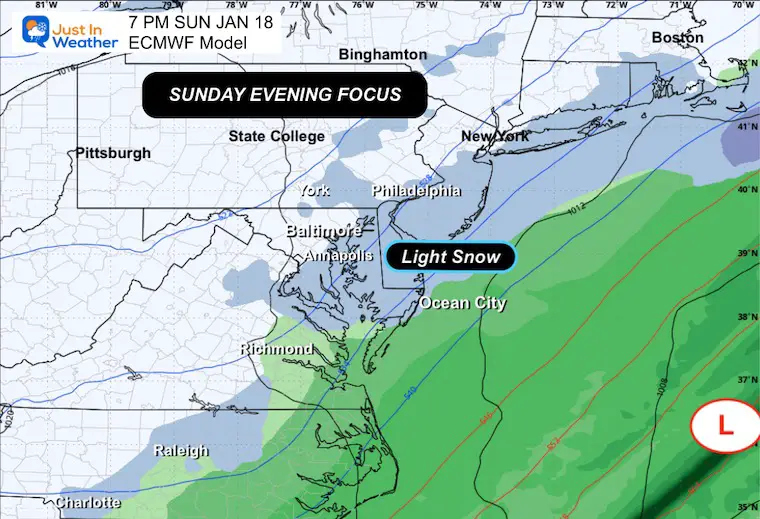
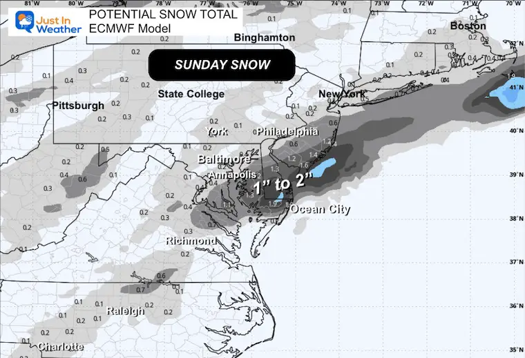
A more organized Low Pressure will form farther south on Sunday. This is what is expected to bring snow to Northern Florida and South Georgia. The back edge of this will clip the Mid Atlantic and most likely to include Delmarva and the beaches. The computer guidance has some hint to carry light snow to the Western EDGE of the Chesapeake Bay. But my focus is on where some stickage may affect roads for now.
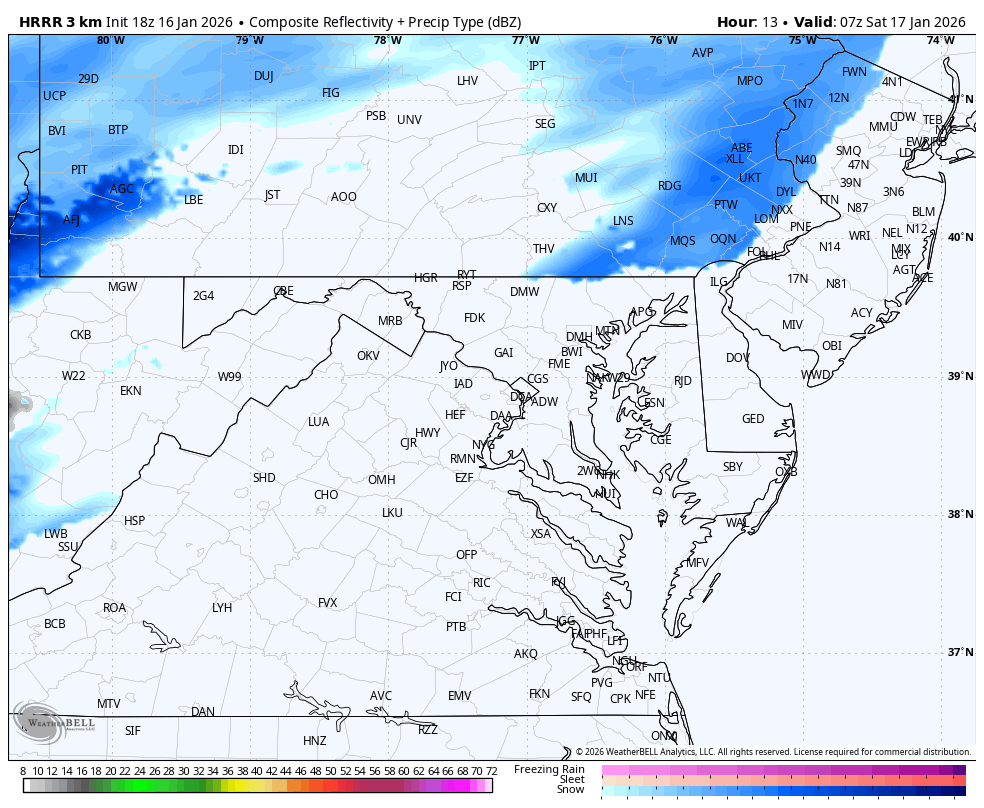
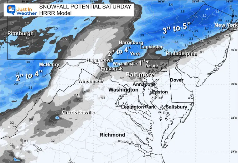
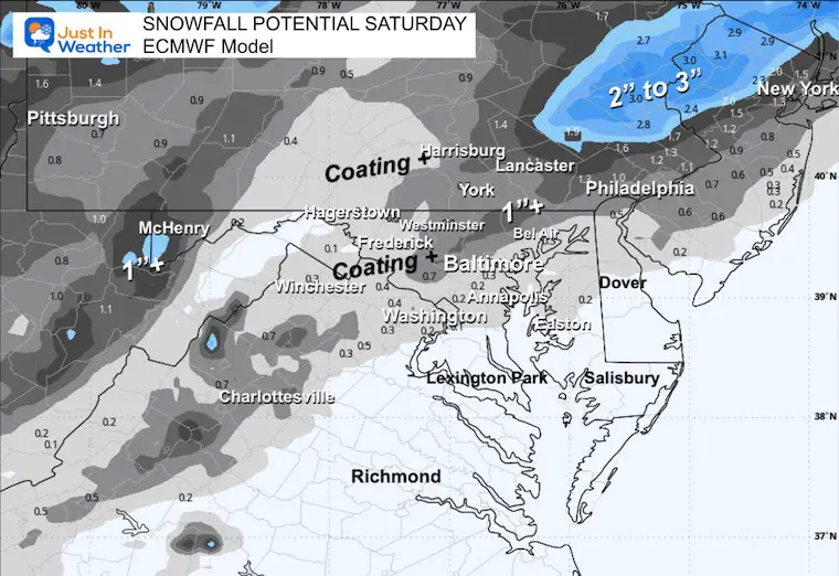
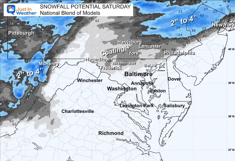
Here is a quick look that includes My Call For Snowfall Saturday. Then the model guidance for Sunday’s event.
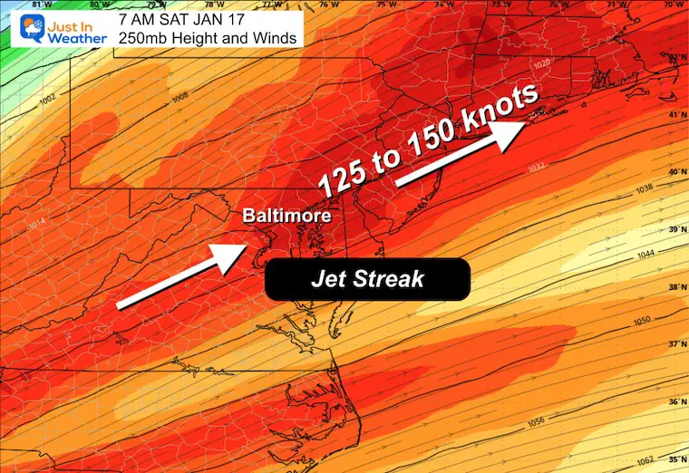
For Baltimore and the Mid-Atlantic: A developing system is heading our way! Rain and snow are organizing to our west and will move toward the region overnight into Saturday morning.
Winds will exceed 150 knots by daybreak. That helps instability and the developing precipitation.
This is the spin around 5,000 Ft is where we will watch the clouds produce the snow and mix for us.
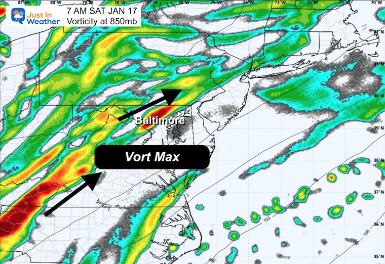
Compare to the Model Forecast Plots Below
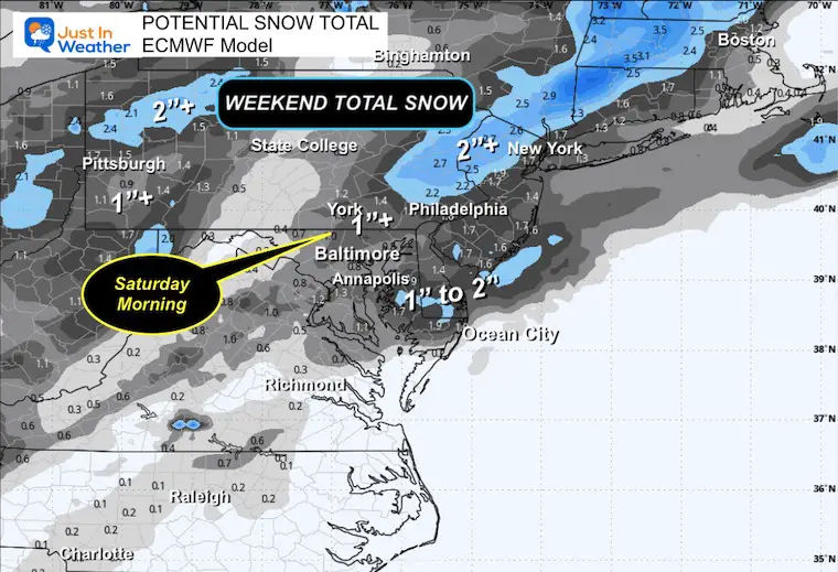
Slushy and mostly wet roads near Baltimore. Inland Suburbs from a coating to 1” from Eldersburg to Frederick. A better chance to get over 1 inch near Westminster, Hereford, up north near the PA line. A better chance for 2 inches will be near and north of the Pennsylvania Line.
There will be parts of the Poconos that could get higher amounts and my region on this map may be wider depending on the speed and intensity of that initial push of wet snow.
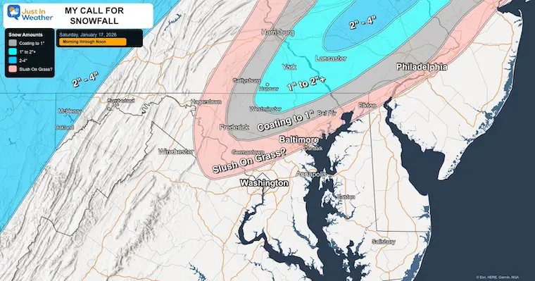
Watch the snow on the HRRR Model expand before sunrise. This will affect Southern Pennsylvania and mountain areas first, and the early hours will coincide with colder temps and allow for more snow and some accumulation.
Snow may be affecting roads near Frederick, Westminster, and Southern Pennsylvania when you wake up.
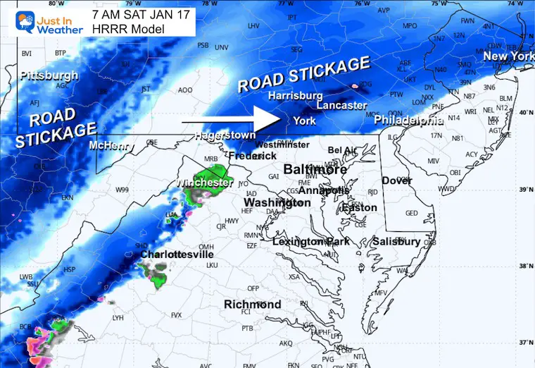
Notice the freezing line holding within 10 to 15 miles of the Maryland/Pennsylvania line.
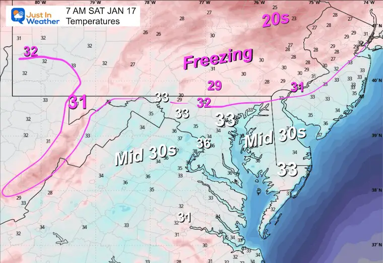
Slushy wet snow will continue in the colder areas. As the line of precipitation spreads east toward Washington and Baltimore it will mix with and change to rain.
There will be areas in the suburbs that get snow falling and only sticking on the grass, then eventually just melting.
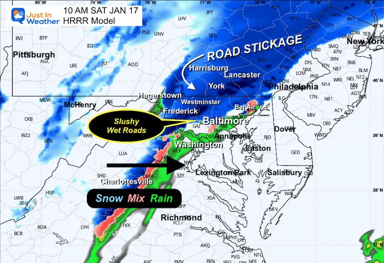
A mix of wet slushy snow and rain will cross I-95 around this time. Heavy slushy snow may be falling between northeastern Maryland to Philadelphia and New York.
Heavy slushy snow may be falling between Philadelphia and New York.
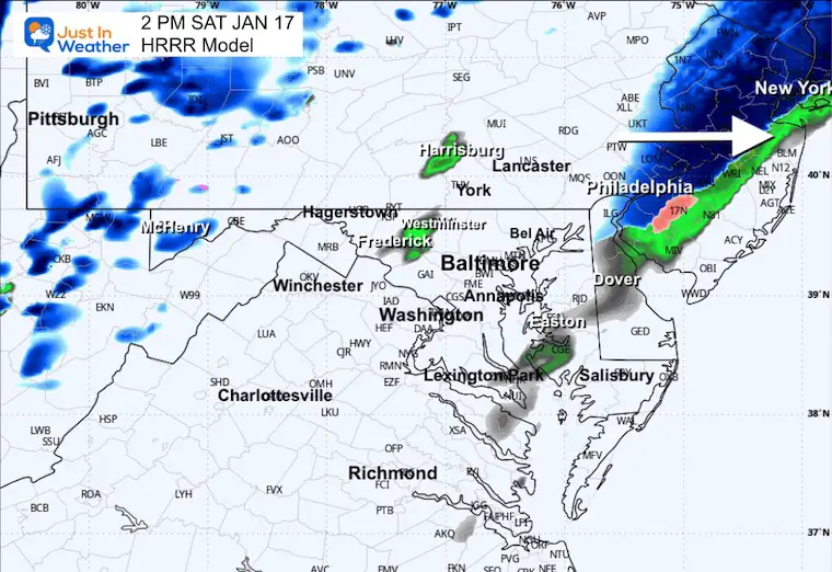
We will be warming up with and after this arrives. So any snow that falls will melt quickly.
This is the MOST AGGRESSIVE totals!
Watch the system develop with snow across North Florida, then Low Pressure off the Southeast US Coast.
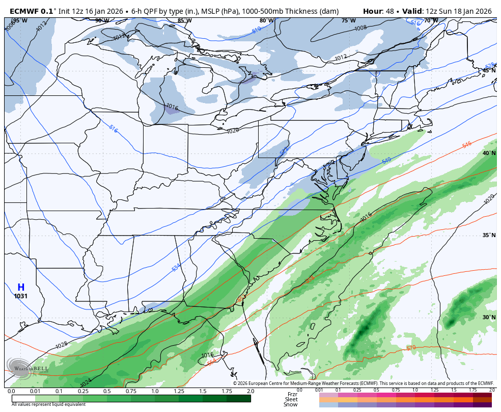
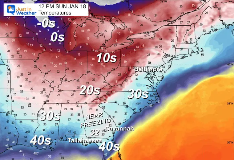
This shows the near freezing temps under the moderate snow near Tallahassee FL to Savannah GA.
Our region should be in the Mid 30s, which is important IF there is snow falling then!
I will be up early Saturday to track what may be falling with you on social media.
Subscribe for email Alerts
Sign up and be the first to know!

In case you missed it, click this image for brief summary of the final snow totals from the last event.

In case you missed it, click this image for brief summary of the final snow totals from the last event.

Click here for the full report

This was issued October 9, as expected: A weak and short-lived event to start winter may play a different role this winter.

These are NOT all the same caterpillar!


Click to see more and ‘Book’ a visit to your school


The annual event: Hiking and biking 329 miles in 7 days between The Summit of Wisp to Ocean City.
Each day, we honor a kid and their family’s cancer journey.
Fundraising is for Just In Power Kids: Funding Free Holistic Programs. I never have and never will take a penny. It is all for our nonprofit to operate.
Click here or the image to donate:

I am aware there are some spelling and grammar typos and occasional other glitches. I take responsibility for my mistakes and even the computer glitches I may miss. I have made a few public statements over the years, but if you are new here, you may have missed it: I have dyslexia and found out during my second year at Cornell University. It didn’t stop me from getting my meteorology degree and being the first to get the AMS CBM in the Baltimore/Washington region. One of my professors told me that I had made it that far without knowing and to not let it be a crutch going forward. That was Mark Wysocki, and he was absolutely correct! I do miss my mistakes in my own proofreading. The autocorrect spell check on my computer sometimes does an injustice to make it worse. I can also make mistakes in forecasting. No one is perfect at predicting the future. All of the maps and information are accurate. The ‘wordy’ stuff can get sticky. There has been no editor who can check my work while writing and to have it ready to send out in a newsworthy timeline. Barbara Werner is a member of the web team that helps me maintain this site. She has taken it upon herself to edit typos when she is available. That could be AFTER you read this. I accept this and perhaps proves what you read is really from me… It’s part of my charm. #FITF