Monday January 12
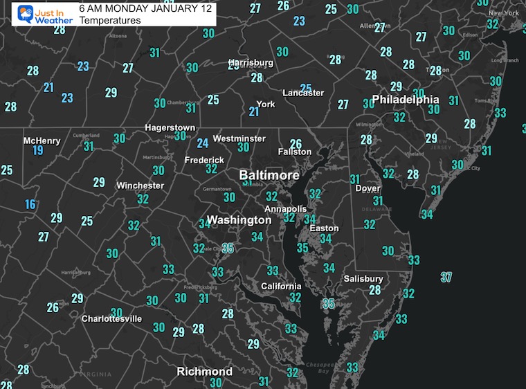
We return to the work week with a return to seasonal temperatures. Any morning clouds will be replaced by clear skies that have already reached inland areas west and north.
There will be one more rise in temperatures over the next few days, then we look later in the week for some signal of winter.
Looking Ahead: That snow potential for Thursday Night to Friday Morning is still, in my opinion, NOT going to be a major event. We will have colder air setting up for at least two weeks to follow.
This is the post where I will show you that the modeling has less support with a less organized system. It is my experience that it will pivot back to a little more substance, but still a smaller event. Light snow will be a reminder of the season, and we might have more flurries or light snow into the weekend.
I need to repeat my message: Computer guidance has been poor and is simply guidance. I show you the maps I support or contrast to explain the low confidence.
Morning Temperatures
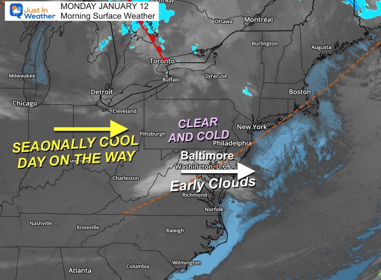
Morning Surface Weather
A disturbance is dragging a cluster of clouds moving through the region, but clearing has already returned inland west and north. This will expand during the morning.
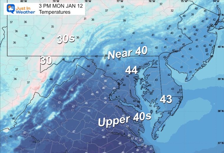
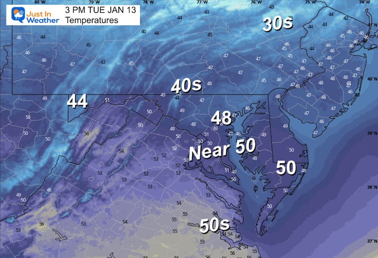
Expect a sunny afternoon with temps near seasonal average levels.
Not much more to see in this view. The larger vantage will show the changes on the way later this week.
Wind Forecast 7 AM to 8 PM

Afternoon Temperatures
MOUNTAIN CAM:
WESTERN MARYLAND
This webcam is positioned at The Greene Turtle Deep Creek Lake and shows Wisp Resort, including a zoomed-in view of Squirrel Cage, The Face, the terrain park, Boulder, the mountain coaster, the tubing park and a shot of McHenry Cove at Deep Creek Lake!
CLIMATE DATA: Baltimore
Yesterday: Low 34°F; High 49°F
Precipitation: Trace
Season Snow Total: 2.0″
Snow Depth: 0″
Top Wind Gust: 52 mph
TODAY January 12
Sunrise at 7:25 AM
Sunset at 5:05 PM
Normal Low in Baltimore: 26ºF
Record Low: 1ºF in 1981
Normal High in Baltimore: 43ºF
Record High: 70ºF in 1890, 2017 & 2020
Rainfall Deficit at BWI
- Prior 2 Years (2024 + 2025) = -16.91″
- Since Jan 1, 2026 = -0.17″
TUESDAY
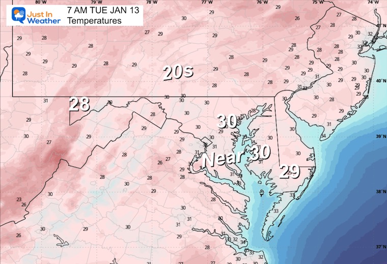
Morning Temperatures
Afternoon Temperatures
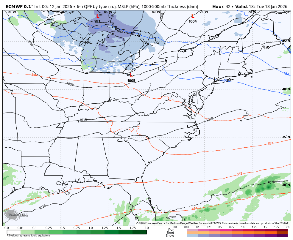
Storm Forecast Tuesday to Friday Afternoon
The shift back to colder air will still have some ripples in it.
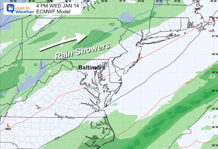
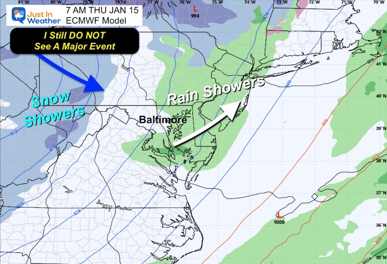
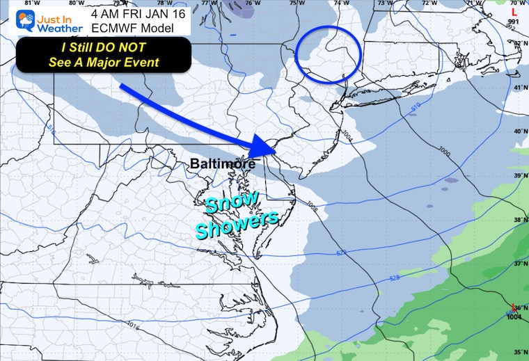
Rain showers for our region will be replaced by snow showers. Here we see the ECMWF Model fading the snow on Thursday night. I do believe there will be a little more than shown here, but still NOT a storm.
Wednesday Snapshot
Thursday Snapshot
Friday Snapshot
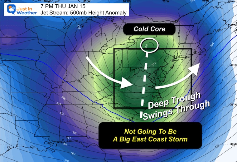
Jet Stream Snapshot
We see a cold setup and a deep trough stretching into the Southeastern US.
This is only one part of the pattern, but this one is not going to be conducive to a larger storm. It does help set the stage for more potential over the next two weeks.
Jet Stream Forecast Jan 15 to Next Wed Jan 21
This is a cold and active pattern that will likely include smaller systems.
I see multiple chances in the wider two-week window that keep us busy.
It is important to note that this is a pattern set up. The computer guidance has been poor for identifying larger storm systems…. So no specifics.

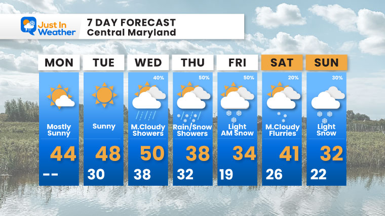
7-Day Forecast
Winter is still in transition to build back, which means a mild day or two in the mix.
As I have been trying to highlight for a few days, I do not see a major storm. Still watching light snow Thursday night to Friday and again over the weekend.
Faith In The Flakes!
- Monday: Mostly sunny. High 44°F.
- Tuesday: Sunny. High 48°F, Low 30°F.
- Wednesday: Mostly cloudy with showers (40%). High 50°F, Low 38°F.
- Thursday: Rain/snow showers (50%). High 38°F, Low 32°F.
- Friday: Light AM snow (50%). High 34°F, Low 19°F.
- Saturday: Mostly cloudy with flurries (20%). High 41°F, Low 26°F.
- Sunday: Light snow (30%). High 32°F, Low 22°F.
Subscribe for email Alerts
FAITH IN THE FLAKES STORE
NOW OPEN FOR THE SEASON
click here

Snow Report December 14 and Grade My Forecast
In case you missed it, click this image for brief summary of the final snow totals from the last event.

Snow Report December 5 to 6 and Grade My Forecast
In case you missed it, click this image for brief summary of the final snow totals from the last event.

My Winter Outlook For Above-Average Snow
Click here for the full report

La Niña Advisory
This was issued October 9, as expected: A weak and short-lived event to start winter may play a different role this winter.

In Case You Missed It
Woolly Bear Caterpillar Winter Folklore
These are NOT all the same caterpillar!

Winter Outlook From 2 Farmers’ Almanacs

STEM Assemblies/In School Fields Trips Are Back
Click to see more and ‘Book’ a visit to your school

THANK YOU:
Baltimore Sun Magazine Readers’ Choice Best Of Baltimore

Maryland Trek 12 Day 7 Completed Sat August 9
UPDATED: We raised OVER $170,000 for Just In Power Kids – AND Still Collecting More
The annual event: Hiking and biking 329 miles in 7 days between The Summit of Wisp to Ocean City.
Each day, we honor a kid and their family’s cancer journey.
Fundraising is for Just In Power Kids: Funding Free Holistic Programs. I never have and never will take a penny. It is all for our nonprofit to operate.
Click here or the image to donate:

RESTATING MY MESSAGE ABOUT DYSLEXIA
I am aware there are some spelling and grammar typos and occasional other glitches. I take responsibility for my mistakes and even the computer glitches I may miss. I have made a few public statements over the years, but if you are new here, you may have missed it: I have dyslexia and found out during my second year at Cornell University. It didn’t stop me from getting my meteorology degree and being the first to get the AMS CBM in the Baltimore/Washington region. One of my professors told me that I had made it that far without knowing and to not let it be a crutch going forward. That was Mark Wysocki, and he was absolutely correct! I do miss my mistakes in my own proofreading. The autocorrect spell check on my computer sometimes does an injustice to make it worse. I can also make mistakes in forecasting. No one is perfect at predicting the future. All of the maps and information are accurate. The ‘wordy’ stuff can get sticky. There has been no editor who can check my work while writing and to have it ready to send out in a newsworthy timeline. Barbara Werner is a member of the web team that helps me maintain this site. She has taken it upon herself to edit typos when she is available. That could be AFTER you read this. I accept this and perhaps proves what you read is really from me… It’s part of my charm. #FITF
Please share your thoughts and best weather pics/videos, or just keep in touch via social media.


