Saturday January 10, 2026
Here comes the rain again. While Baltimore only got 0.03” of rain yesterday, today will mark a second day in a row with rain that only happened twice last month. We have a big rainfall deficit, and the expectation today may bring nearly 1 inch to the city and southward.
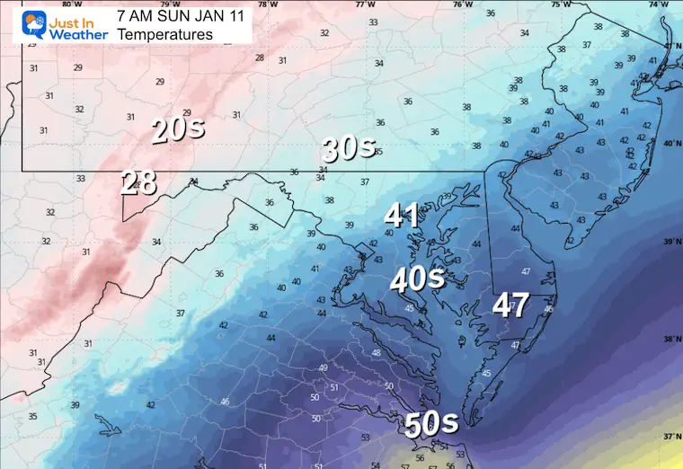
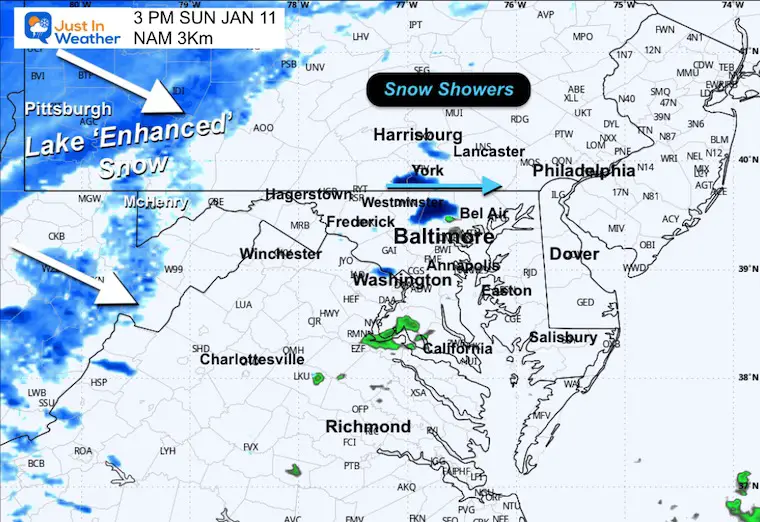
Colder air will make a return on Sunday, and with it, some snow showers could cross parts of Central Maryland. The western part of the state will get a fresh accumulation in the high mountains.
Looking into the week ahead, the upper-level jet stream pattern looks like it will have a firm winter grip on the Eastern US. This is the pattern, not the promise at the surface. Our computer model guidance is imperfect, and as you may have seen on your social media feed, one model may show a big snowstorm while another does not. BOTH are likely to change! That is why I am sticking with the jet stream instead. The surface weather results will be refined as the ingredients come in to better focus.
If you love (or hate) winter, the next 10 to 20 days look like a prime window of opportunity to pay attention to.
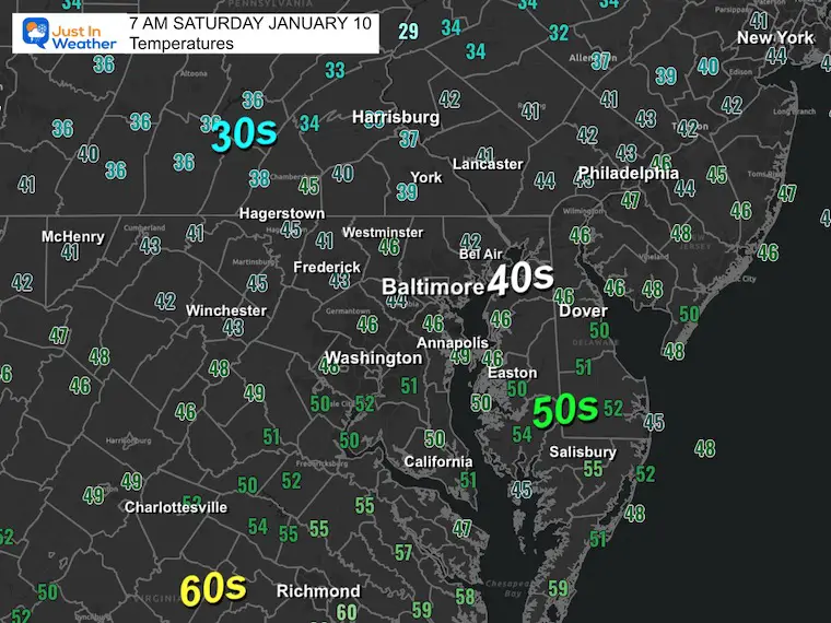
Morning Temperatures
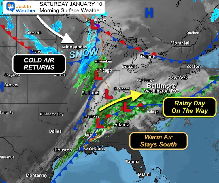
The stationary front you will see in the map below gets stuck farther south. This was addressed yesterday, and why our current temperatures may not move much all day. The warm air will not get in today, but the rain surely will.
Morning Surface Weather
For Baltimore and the Mid-Atlantic: Rainy day on the way! Rain is approaching from the west and will bring steady to heavy rain through the afternoon. This is the needed rain we’ve been talking about.
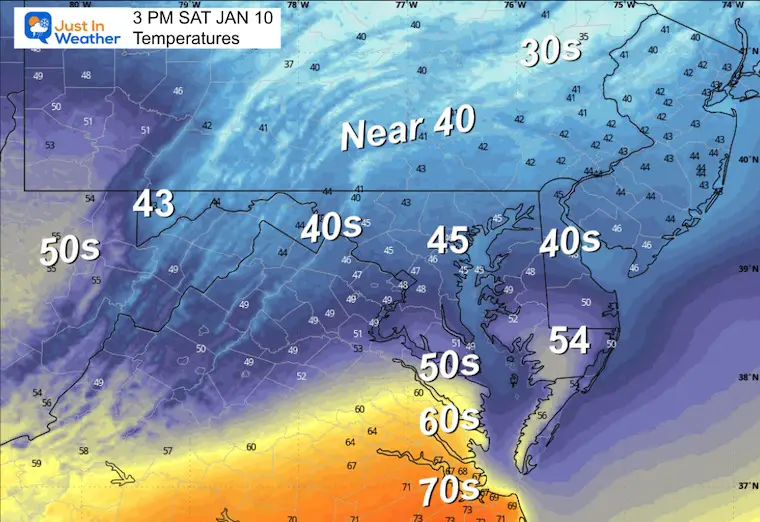
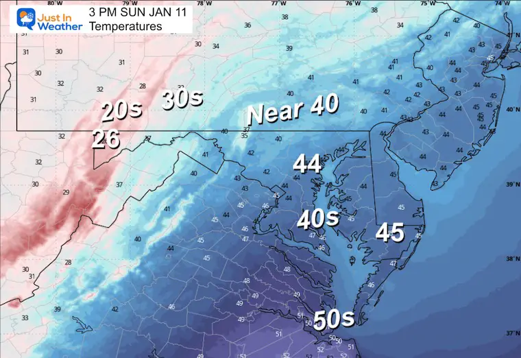
- Warm Air Stays South: The warmer air has remained to our south, which is why temperatures today won’t be as mild as originally expected — highs only in the upper 40s instead of the 60s.
- Snow to the North: Heavy snow is falling across the northern Plains and Upper Midwest from Minnesota through Wisconsin.
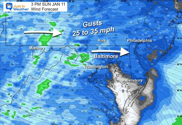
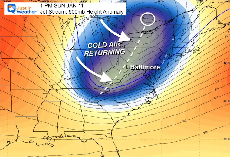
- Cold Air Returns: Behind this system, colder air is building across the northern tier and will push into the Mid-Atlantic by Sunday. Expect windy and colder conditions to close out the weekend.
Live Radar Widget
Radar Forecast Simulation 7 AM to Midnight

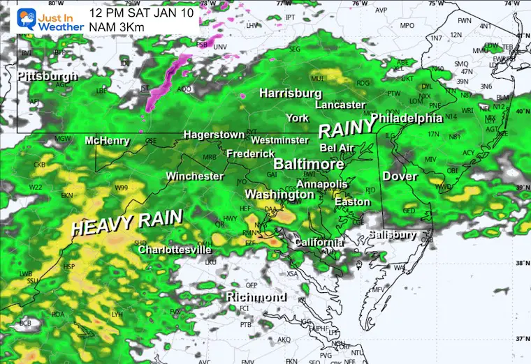
Noon Snapshot
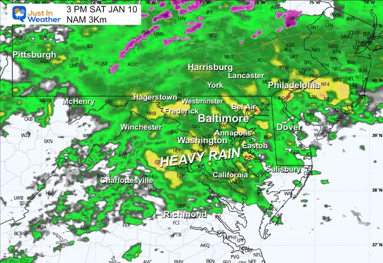
Afternoon Snapshot
AFTERNOON Temperatures
Tonight
The push of rain with this line along the cold front will be crossing Southern Maryland, and may get stuck there much of tonight.

POTENTIAL TOTAL RAINFALL
This is from a blend of global models:
A large swath of over 1 inch along and south of the heavily populated I-95 corridor.
Most will fall today, and some additional rainfall, as shown here, includes showers tomorrow.

MOUNTAIN CAM:
WESTERN MARYLAND
This webcam is positioned at The Greene Turtle Deep Creek Lake and shows Wisp Resort, including a zoomed-in view of Squirrel Cage, The Face, the terrain park, Boulder, the mountain coaster, the tubing park and a shot of McHenry Cove at Deep Creek Lake!
CLIMATE DATA: Baltimore
Yesterday: Low 31°F; High 54°F
Precipitation: 0.03″
Season Snow Total: 2.0″
Snow Depth: 0″
Top Wind Gust: 16 mph
TODAY January 10
Sunrise at 7:26 AM
Sunset at 5:03 PM
Normal Low in Baltimore: 26ºF
Record Low: -2ºF in 1875
Normal High in Baltimore: 43ºF
Record High: 70ºF in 1950
Rainfall Deficit at BWI
- Prior 2 Years (2024 + 2025) = -16.91″
- Since Jan 1, 2026 = -0.87″
SUNDAY
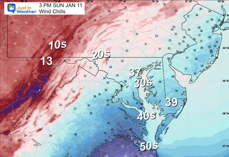
Colder Winds will usher in the return of winter. This may include additional showers in the afternoon that may mix with snow. Steady, accumulating snow will return to the Western Maryland Mountains.
Morning Temperatures
Wind Forecast 7 AM to Midnight

Radar Simulation 7 AM to 7 PM

Afternoon Radar Snapshot
Afternoon Wind Forecast
Afternoon Temperatures
Afternoon Wind Chills
LOOKING AHEAD
Jet Stream Sunday Afternoon
The first signal of winter making a return…
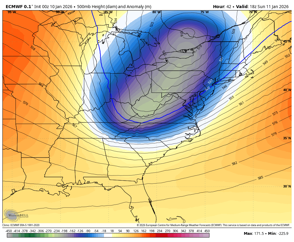
Jet Stream Forecast Sunday, Jan 11 to Sun Jan 18
After cold air returns tomorrow, there will be a few more impulses of cold air into the Eastern US through next weekend.
This is the upper-level pattern that supports active weather. The reflection on the surface is less certain and still needs refining. That is why I am not showing surface storms. You can find one model that shows plenty of snow, and another that does not. Both are likely to change as the ingredients needed come into better focus.
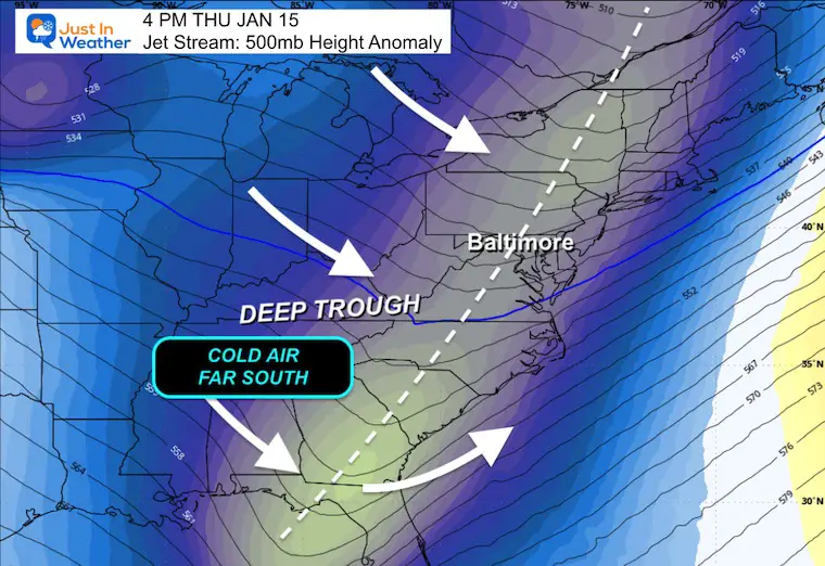
Next Thursday Jan 15
This DEEP TROUGH is a strong signal of well below average temperatures into the Gulf Coast, and may help develop a new storm with winter weather.
Next Sunday, Jan 18
While in the midst of a colder pattern, we will watch for more energy to attempt snow production.

7-Day Forecast
Rain today, then the cold returns!
Winter is making a comeback!
Thursday’s rain/snow mix still in play — and Friday looks quite cold.
- Saturday: Rainy (100%). High 48°F.
- Sunday: Windy and colder (30% showers). High 44°F, Low 41°F.
- Monday: Mostly sunny. High 42°F, Low 29°F.
- Tuesday: Sunny. High 48°F, Low 30°F.
- Wednesday: Mostly cloudy. High 49°F, Low 39°F.
- Thursday: Rain/snow showers (30%). High 39°F, Low 30°F.
- Friday: Mostly cloudy. High 36°F, Low 22°F
Subscribe for email Alerts
FAITH IN THE FLAKES STORE
NOW OPEN FOR THE SEASON
click here

Snow Report December 14 and Grade My Forecast
In case you missed it, click this image for brief summary of the final snow totals from the last event.

Snow Report December 5 to 6 and Grade My Forecast
In case you missed it, click this image for brief summary of the final snow totals from the last event.

My Winter Outlook For Above-Average Snow
Click here for the full report

La Niña Advisory
This was issued October 9, as expected: A weak and short-lived event to start winter may play a different role this winter.

In Case You Missed It
Woolly Bear Caterpillar Winter Folklore
These are NOT all the same caterpillar!

Winter Outlook From 2 Farmers’ Almanacs

STEM Assemblies/In School Fields Trips Are Back
Click to see more and ‘Book’ a visit to your school

THANK YOU:
Baltimore Sun Magazine Readers’ Choice Best Of Baltimore

Maryland Trek 12 Day 7 Completed Sat August 9
UPDATED: We raised OVER $170,000 for Just In Power Kids – AND Still Collecting More
The annual event: Hiking and biking 329 miles in 7 days between The Summit of Wisp to Ocean City.
Each day, we honor a kid and their family’s cancer journey.
Fundraising is for Just In Power Kids: Funding Free Holistic Programs. I never have and never will take a penny. It is all for our nonprofit to operate.
Click here or the image to donate:

RESTATING MY MESSAGE ABOUT DYSLEXIA
I am aware there are some spelling and grammar typos and occasional other glitches. I take responsibility for my mistakes and even the computer glitches I may miss. I have made a few public statements over the years, but if you are new here, you may have missed it: I have dyslexia and found out during my second year at Cornell University. It didn’t stop me from getting my meteorology degree and being the first to get the AMS CBM in the Baltimore/Washington region. One of my professors told me that I had made it that far without knowing and to not let it be a crutch going forward. That was Mark Wysocki, and he was absolutely correct! I do miss my mistakes in my own proofreading. The autocorrect spell check on my computer sometimes does an injustice to make it worse. I can also make mistakes in forecasting. No one is perfect at predicting the future. All of the maps and information are accurate. The ‘wordy’ stuff can get sticky. There has been no editor who can check my work while writing and to have it ready to send out in a newsworthy timeline. Barbara Werner is a member of the web team that helps me maintain this site. She has taken it upon herself to edit typos when she is available. That could be AFTER you read this. I accept this and perhaps proves what you read is really from me… It’s part of my charm. #FITF
Please share your thoughts and best weather pics/videos, or just keep in touch via social media.


