Monday December 29
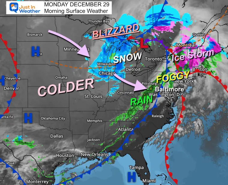
The Bomb Cyclone in the Great Lakes is still the headline feature event. A true blizzard is moving through the Upper Midwest and parts of Michigan, while an ice storm is affecting New England, and we are experiencing the tail end of rain with the cold front.
Ahead of this, warm temps and even thick fog this morning have prompted an Advisory in Pennsylvania.
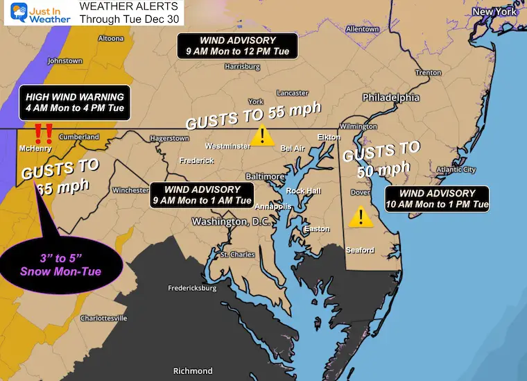
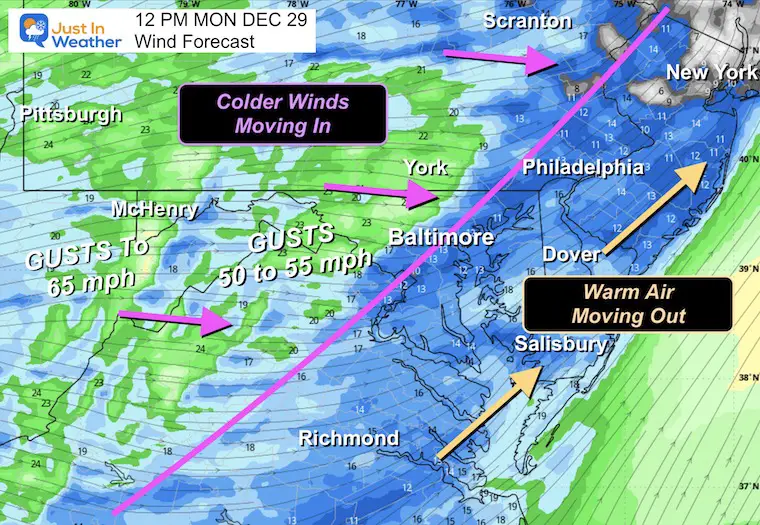
The cold front will pass through late morning to midday, then winds crank up with gusts approaching 50 mph. In the Western Maryland mountains, winds may reach 65 mph as a few inches of snow are expected as well… Weather Alerts have been issued for both.
Colder air will settle in for the rest of the week. Then we shift our focus to a clipper that will attempt to bring us light snow on New Year’s Eve and Day.
Weather Alerts
Wind Advisory: Winds 50 to 55 mph
High Wind Warning AND Winter Weather Advisory: High Mountains can expect gusts of 65 mph in addition to snow ranging from 2 inches to some spots up to 6 inches. That is typical with banding snow enhanced by the Great Lakes.
ANIMATIONS 7 AM to Midnight
Radar Simulation
Wind Forecast
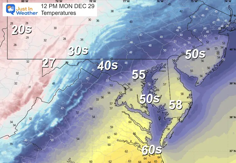
Temperature Forecast
Morning Surface Weather
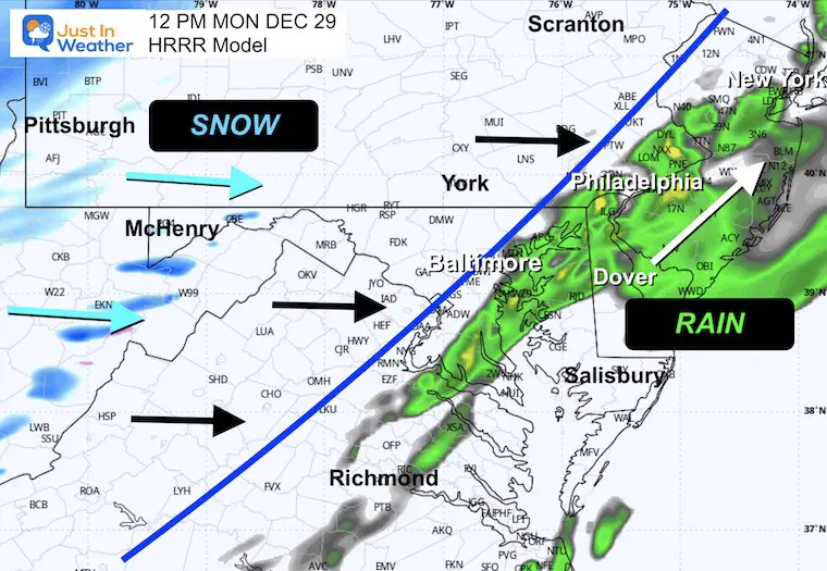
The cold front associated with the Storm Center has a line of rain with it, however that will be breaking up across the mountains.
The wind will pick up dramatically after the front passes.
Storm Forecast: Today through Thursday Morning
Following the storm, cold air intrusion then clipper with light snow.
LIVE RARAR WIDGET
SNAPHOTS
NOON: Close to FROPA (Frontal Passage)
Radar Simulation
Temperatures
Wind Forecast
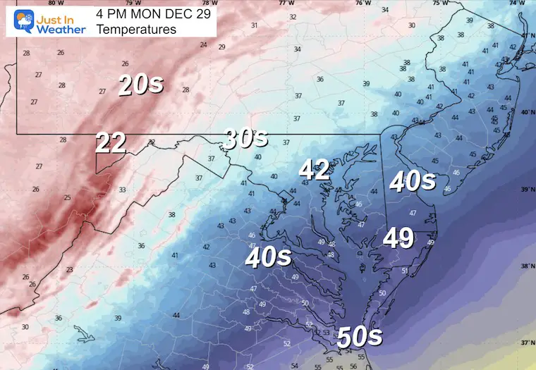
AFTERNOON:
Temperatures
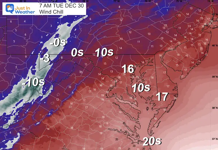
Wind Chills

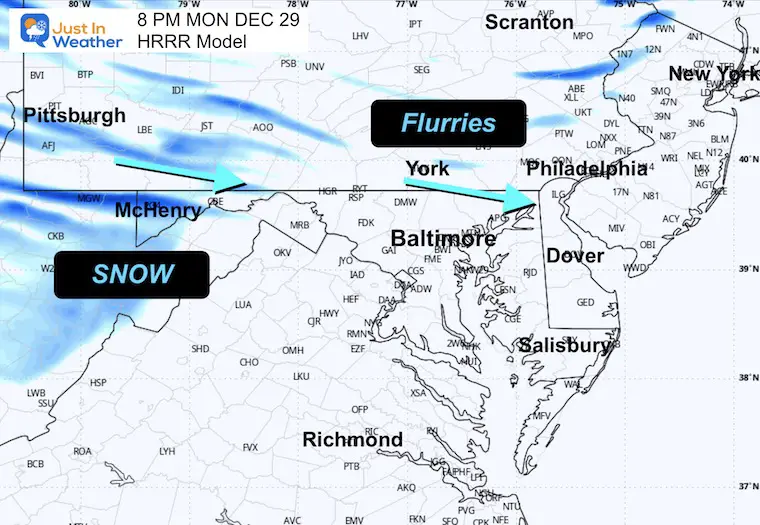
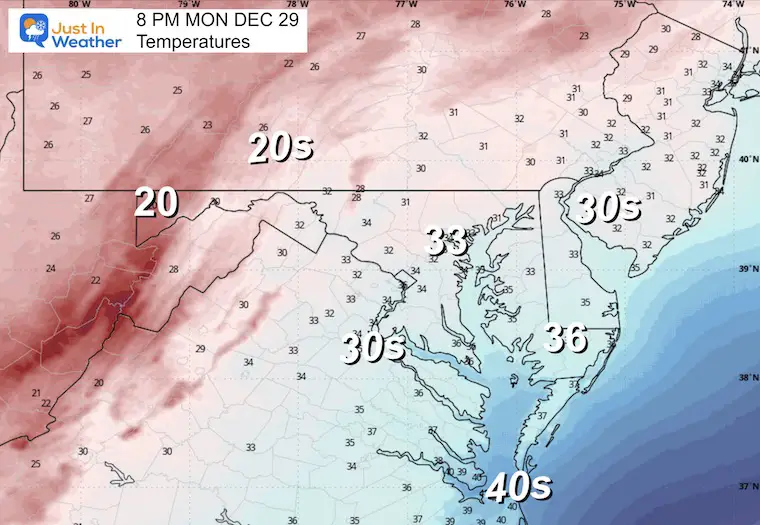
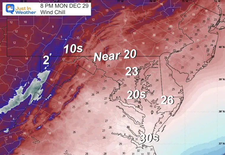
EVENING
Radar
Temperatures
Wind Chills
MOUNTAIN CAM:
WESTERN MARYLAND
Wind is still in full force in this region. A fresh coating to few inches of snow has blanketed the region.
This webcam is positioned at The Greene Turtle Deep Creek Lake and shows Wisp Resort, including a zoomed-in view of Squirrel Cage, The Face, the terrain park, Boulder, the mountain coaster, the tubing park and a shot of McHenry Cove at Deep Creek Lake!
CLIMATE DATA: Baltimore
Yesterday: Low 33°F; High 44°F
Precipitation: Trace
Season Snow Total: 2.0″
Snow Depth: 0″
Top Wind Gust: 16 mph
TODAY December 29
Sunrise at 7:26 AM
Sunset at 4:52 PM
Normal Low in Baltimore: 27ºF
Record Low: 2ºF in 1917
Normal High in Baltimore: 45ºF
Record High: 77ºF in 1984
Rainfall Deficit at BWI
* Ending 2024 = -8.00″
* Since Jan 1 = -8.71″
* We are STILL DOWN -16.71″ INCLUDING LAST YEAR
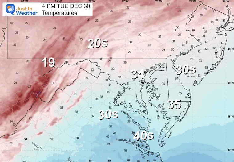
TUESDAY
Cold air will be fully established as gusty winds will remain, but they won’t be as strong.
Morning
Temperatures

Wind Chills
Afternoon
Temperatures
Wind Chills

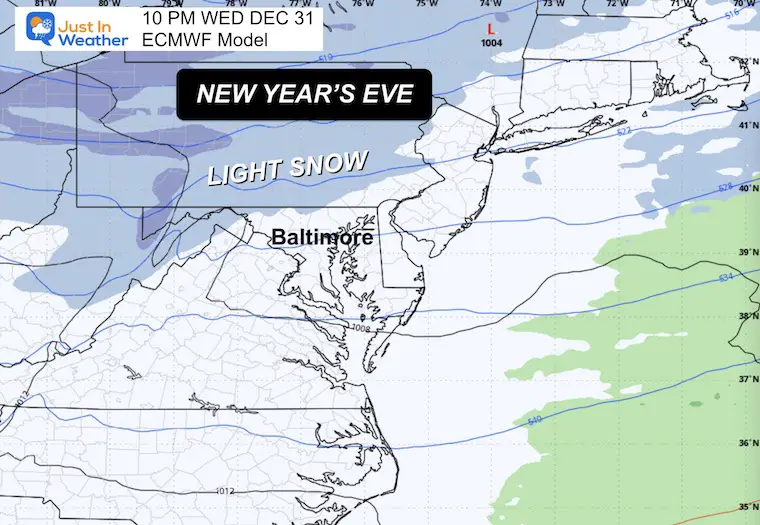
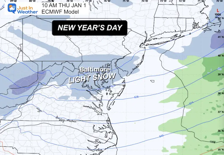
LIGHT SNOW AROUND THE NEW YEAR
With Arctic air already in place, a clipper system is expected to cross the region, bringing a chance for light snow from Wednesday evening into Thursday morning.
At this point, I am focusing on the ‘confetti’ falling from the sky and using the word ‘light’. I would not change any plans at this time. But after the front crosses today, I will have a better idea of what may fall and accumulate.
New Year’s Eve
New Year’s Day
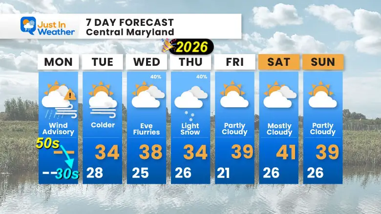
7 Day Forecast: Central Maryland
- Monday: Wind Advisory | High 50s → 30s (Falling Temps)
- Tuesday: Colder | High 34°F / Low 28°F
- Wednesday: Evening Flurries | High 38°F / Low 25°F | 40% chance
- Thursday: Light Snow | High 34°F / Low 26°F | 40% chance
- Friday: Partly Cloudy | High 39°F / Low 21°F
- Saturday: Mostly Cloudy | High 41°F / Low 26°F
- Sunday: Partly Cloudy | High 39°F / Low 26°F
Subscribe for email Alerts
FAITH IN THE FLAKES STORE
NOW OPEN FOR THE SEASON
click here

Snow Report December 14 and Grade My Forecast
In case you missed it, click this image for brief summary of the final snow totals from the last event.

Snow Report December 5 to 6 and Grade My Forecast
In case you missed it, click this image for brief summary of the final snow totals from the last event.

My Winter Outlook For Above-Average Snow
Click here for the full report

La Niña Advisory
This was issued October 9, as expected: A weak and short-lived event to start winter may play a different role this winter.

In Case You Missed It
Woolly Bear Caterpillar Winter Folklore
These are NOT all the same caterpillar!

Winter Outlook From 2 Farmers’ Almanacs

STEM Assemblies/In School Fields Trips Are Back
Click to see more and ‘Book’ a visit to your school

THANK YOU:
Baltimore Sun Magazine Readers’ Choice Best Of Baltimore

Maryland Trek 12 Day 7 Completed Sat August 9
UPDATED: We raised OVER $170,000 for Just In Power Kids – AND Still Collecting More
The annual event: Hiking and biking 329 miles in 7 days between The Summit of Wisp to Ocean City.
Each day, we honor a kid and their family’s cancer journey.
Fundraising is for Just In Power Kids: Funding Free Holistic Programs. I never have and never will take a penny. It is all for our nonprofit to operate.
Click here or the image to donate:

RESTATING MY MESSAGE ABOUT DYSLEXIA
I am aware there are some spelling and grammar typos and occasional other glitches. I take responsibility for my mistakes and even the computer glitches I may miss. I have made a few public statements over the years, but if you are new here, you may have missed it: I have dyslexia and found out during my second year at Cornell University. It didn’t stop me from getting my meteorology degree and being the first to get the AMS CBM in the Baltimore/Washington region. One of my professors told me that I had made it that far without knowing and to not let it be a crutch going forward. That was Mark Wysocki, and he was absolutely correct! I do miss my mistakes in my own proofreading. The autocorrect spell check on my computer sometimes does an injustice to make it worse. I can also make mistakes in forecasting. No one is perfect at predicting the future. All of the maps and information are accurate. The ‘wordy’ stuff can get sticky. There has been no editor who can check my work while writing and to have it ready to send out in a newsworthy timeline. Barbara Werner is a member of the web team that helps me maintain this site. She has taken it upon herself to edit typos when she is available. That could be AFTER you read this. I accept this and perhaps proves what you read is really from me… It’s part of my charm. #FITF
Please share your thoughts and best weather pics/videos, or just keep in touch via social media.


