Saturday December 27, 2025
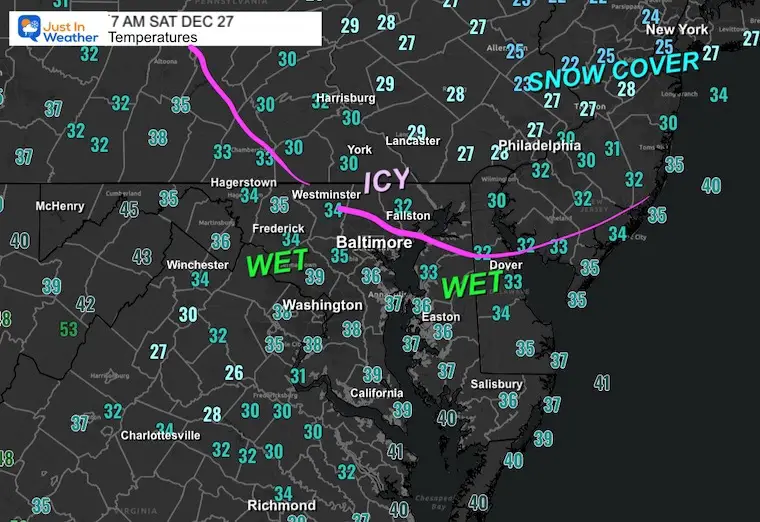
The ice that developed late yesterday was in line with the forecast, though it did little to prevent the numerous car accidents that occurred. The good news is that the storm has ended, and some temps have thawed, but not all. The morning temperatures below will give insight into that, as near and north of the Pennsylvania line may remain icy until after sunrise.
This weekend will be mild with a chance to thaw, only to bring in rain later Sunday into Monday. A brief surge of warm air will be followed by a dramatic cool down later Monday.
Snow will return to the mountains, and a few flurries could reach us on Tuesday.
Then one more arctic blast is expected right as we enter the New Year.
Morning Temperatures
The freezing line and leftover ice are within about 10 miles of the Pennsylvania border into PA.
Main roads should be OK. This is a concern for side roads, untreated driveways, and steps.
Leftover Ice
For those of us who got ice yesterday, you may be something like I have to scrape off, despite if temps thaw.
OR
Just wait an hour or two after sunrise for daylight to help.
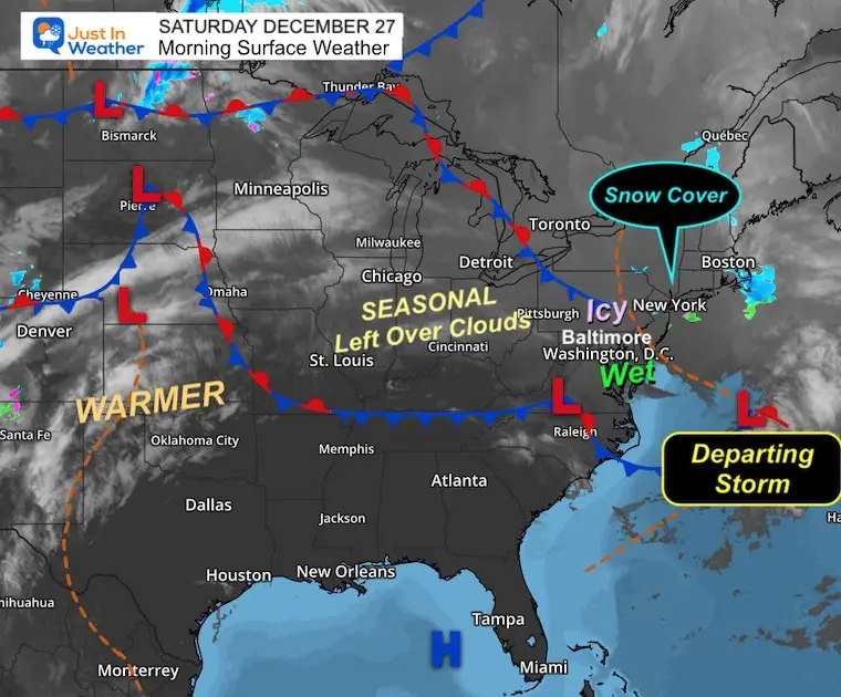
Morning Surface Weather
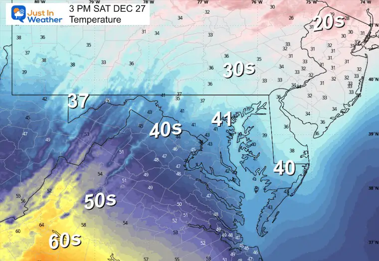
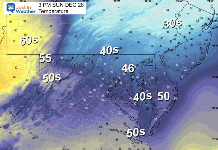
Afternoon Temperatures
MOUNTAIN CAM:
WESTERN MARYLAND
Wind is still in full force in this region. A fresh coating to few inches of snow has blanketed the region.
This webcam is positioned at The Greene Turtle Deep Creek Lake and shows Wisp Resort, including a zoomed-in view of Squirrel Cage, The Face, the terrain park, Boulder, the mountain coaster, the tubing park, and a shot of McHenry Cove at Deep Creek Lake!
CLIMATE DATA: Baltimore
Yesterday: Low 30°F; High 37°F
Precipitation: 0.01″
Season Snow Total: 2.0″
Snow Depth: 0″
Top Wind Gust: 20 mph
TODAY December 27
Sunrise at 7:25 AM
Sunset at 4:51 PM
Normal Low in Baltimore: 28ºF
Record Low: 5ºF in 1914
Normal High in Baltimore: 45ºF
Record High: 69ºF in 2015
Rainfall Deficit at BWI
* Ending 2024 = -8.00″
* Since Jan 1 = -8.49″
We are STILL DOWN -16.49″ INCLUDING LAST YEAR
SUNDAY
This will be mostly cloudy with rain showers developing later in the afternoon and evening.
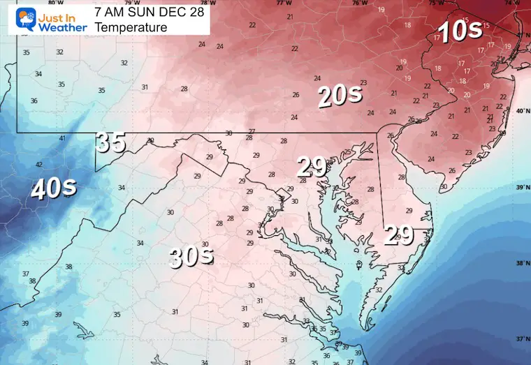
Morning Temperatures
Afternoon Temperatures
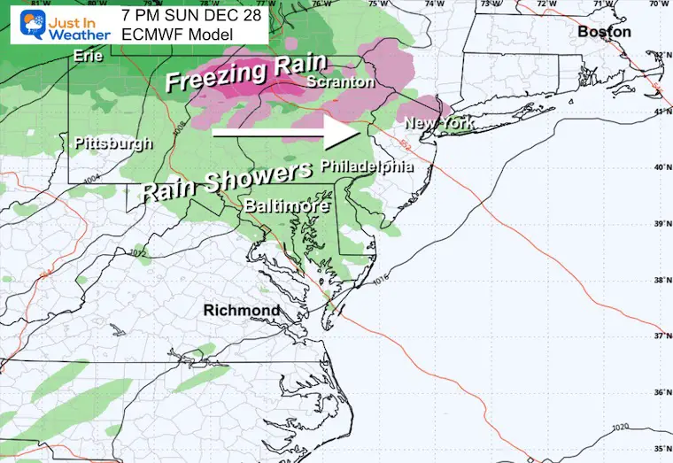
Sunday Evening Snapshot
Rain showers will develop mid-afternoon through the evening. Pockets of freezing rain are expected across Northern Pennsylvania.
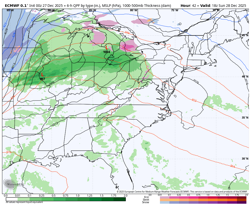
Sunday to Tuesday
A strong cold front will keep most of the energy to our north. We will get some rain showers, but it does look less potent than before.
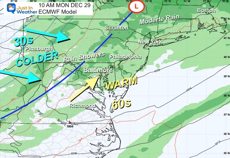
Monday Snapshot
A surge of warm air may push the 60s into Central Maryland and Delmarva, while the 30s will be returning to the mountains. The cold air will push east to the coast later in the day.
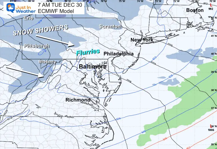
Tuesday Snapshot
Colder air will settle in with gusty winds and lake-enhanced mountain snow. Some flurries will have a chance to cross into our region during the day. No impact expected.
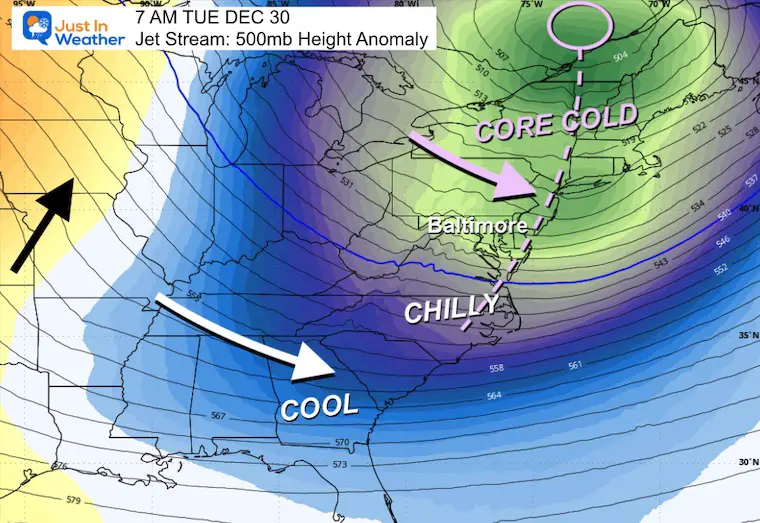
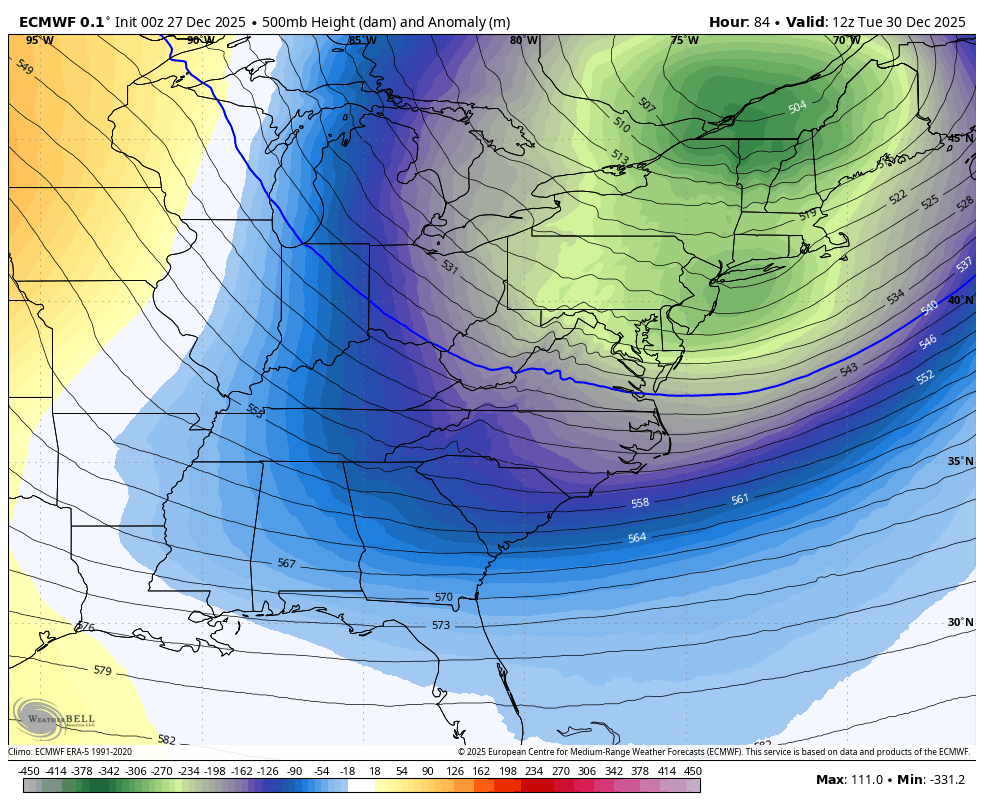
Jet Stream: Tuesday
The first of two cold impulses during the week.
Jet Stream Forecast Tuesday to Thursday
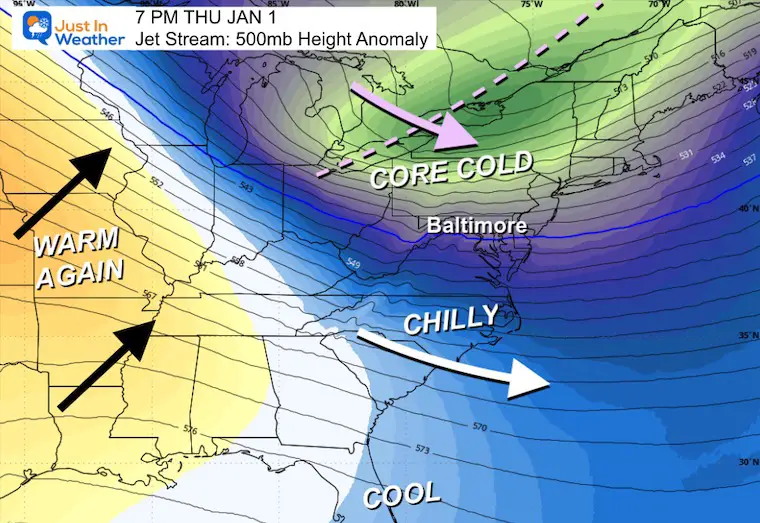
Jet Stream: New Year’s Day
A cold start to 2026.
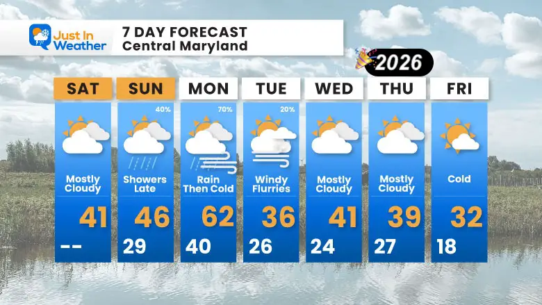
7 Day Forecast: Central Maryland
- Saturday: Mostly Cloudy | High 41°F
- Sunday: Showers Late | High 46°F / Low 29°F |
- Monday: Rain Then Colder | High 62°F / Low 40°F |
- Tuesday: Windy with some Flurries | High 36°F / Low 26°F |
- Wednesday: Mostly Cloudy | High 41°F / Low 24°F
- Thursday: Mostly Cloudy | High 39°F / Low 27°F
- Friday: Cold | High 32°F / Low 18°F
Subscribe for email Alerts
FAITH IN THE FLAKES STORE
NOW OPEN FOR THE SEASON
click here

Snow Report December 14 and Grade My Forecast
In case you missed it, click this image for brief summary of the final snow totals from the last event.

Snow Report December 5 to 6 and Grade My Forecast
In case you missed it, click this image for brief summary of the final snow totals from the last event.

My Winter Outlook For Above-Average Snow
Click here for the full report

La Niña Advisory
This was issued October 9, as expected: A weak and short-lived event to start winter may play a different role this winter.

In Case You Missed It
Woolly Bear Caterpillar Winter Folklore
These are NOT all the same caterpillar!

Winter Outlook From 2 Farmers’ Almanacs

STEM Assemblies/In School Fields Trips Are Back
Click to see more and ‘Book’ a visit to your school

THANK YOU:
Baltimore Sun Magazine Readers’ Choice Best Of Baltimore

Maryland Trek 12 Day 7 Completed Sat August 9
UPDATED: We raised OVER $170,000 for Just In Power Kids – AND Still Collecting More
The annual event: Hiking and biking 329 miles in 7 days between The Summit of Wisp to Ocean City.
Each day, we honor a kid and their family’s cancer journey.
Fundraising is for Just In Power Kids: Funding Free Holistic Programs. I never have and never will take a penny. It is all for our nonprofit to operate.
Click here or the image to donate:

RESTATING MY MESSAGE ABOUT DYSLEXIA
I am aware there are some spelling and grammar typos and occasional other glitches. I take responsibility for my mistakes and even the computer glitches I may miss. I have made a few public statements over the years, but if you are new here, you may have missed it: I have dyslexia and found out during my second year at Cornell University. It didn’t stop me from getting my meteorology degree and being the first to get the AMS CBM in the Baltimore/Washington region. One of my professors told me that I had made it that far without knowing and to not let it be a crutch going forward. That was Mark Wysocki, and he was absolutely correct! I do miss my mistakes in my own proofreading. The autocorrect spell check on my computer sometimes does an injustice to make it worse. I can also make mistakes in forecasting. No one is perfect at predicting the future. All of the maps and information are accurate. The ‘wordy’ stuff can get sticky. There has been no editor who can check my work while writing and to have it ready to send out in a newsworthy timeline. Barbara Werner is a member of the web team that helps me maintain this site. She has taken it upon herself to edit typos when she is available. That could be AFTER you read this. I accept this and perhaps proves what you read is really from me… It’s part of my charm. #FITF
Please share your thoughts and best weather pics/videos, or just keep in touch via social media.


