Friday, December 26, 2025
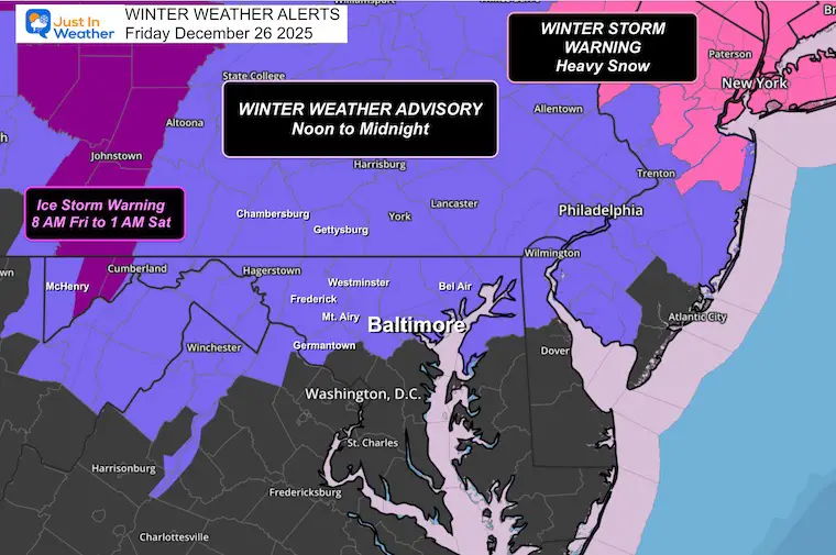
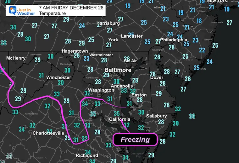
We have a Winter Weather Advisory for part of the region today and tonight. The weather system today is not easy to explain, as Central Maryland will be on the very southern edge of the impact. After reaching the upper 50s on Christmas Day, we have dropped back to freezing this morning, all the way to Southern Maryland.
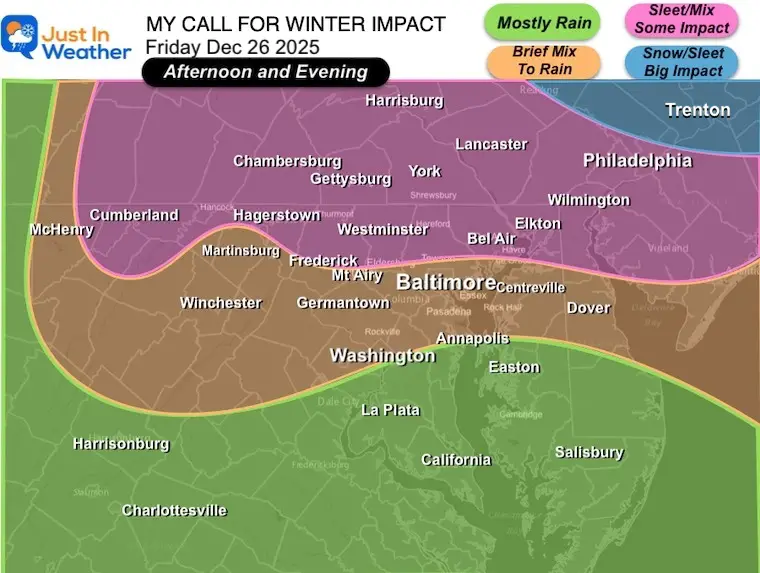
The main change is small, but it will make a big deal. A slight shift north of the earlier track of the storm center will result in the arrival of the ‘bulk’ of the icy mix a little later, and it will be a little lighter. This will allow temperatures to recover just a little more around the metro Baltimore area.
The top items I want to highlight are that this will track just a little farther north. The result for us: Spotty showers may pop midday, but the main event will develop a little later and be a little lighter.
Half of my coverage area will see this as a non-event with light rain. Meanwhile, the other half will experience sleet and freezing rain.
The middle ground is Central Maryland, where the mix will turn to rain. With the bulk of activity arriving a little later, this will allow temps to modify just enough in many metro areas.
The impact of icing will be limited to elevated surfaces. I believe most roads will be OK. That will be different closer to the Pennsylvania line and farther north.
If you are driving North to Pennsylvania, New Jersey, or New York, there will be more ice and some heavy snow.
If you are driving West to the mountains, there will be more ice starting earlier in the day.
While midday may bring some spotty showers, this is mainly a mid-afternoon to evening event. It will be done by midnight!
Saturday looks OK, then the next storm will bring us rain and warmer air Sunday to Monday, followed by an arctic blast lasting through the New Year’s holiday.
Winter Weather Advisory
The southern edge of impact will be NEAR I-70 in Maryland as a rough gauge, but marginal impact with warmer air moving in.
More concern farther West AND North of Baltimore.
My SUGGESTION For Impact Today
Winter Precipitation
The complication with a layer of warm air into the clouds while cold air hugs near the ground.
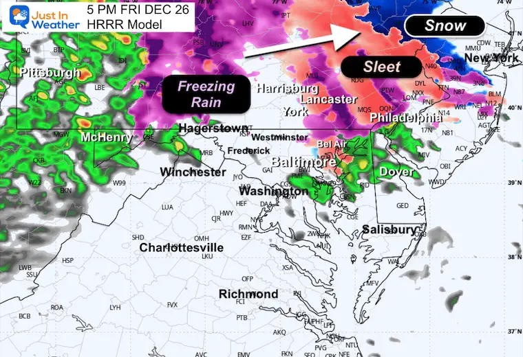
The DEPTH of cold air will determine if rain can freeze to ice pellets (sleet) or remain rain and then freeze on contact with the ground (freezing rain). Both are icy! Sleet is tiny balls of ice, freezing rain is just a layer of glaze that is smooth and more slippery.
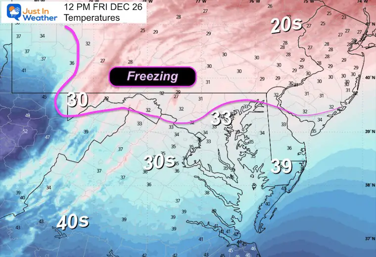
Morning Temperatures
As expected, temps have dropped below freezing in metro Baltimore.
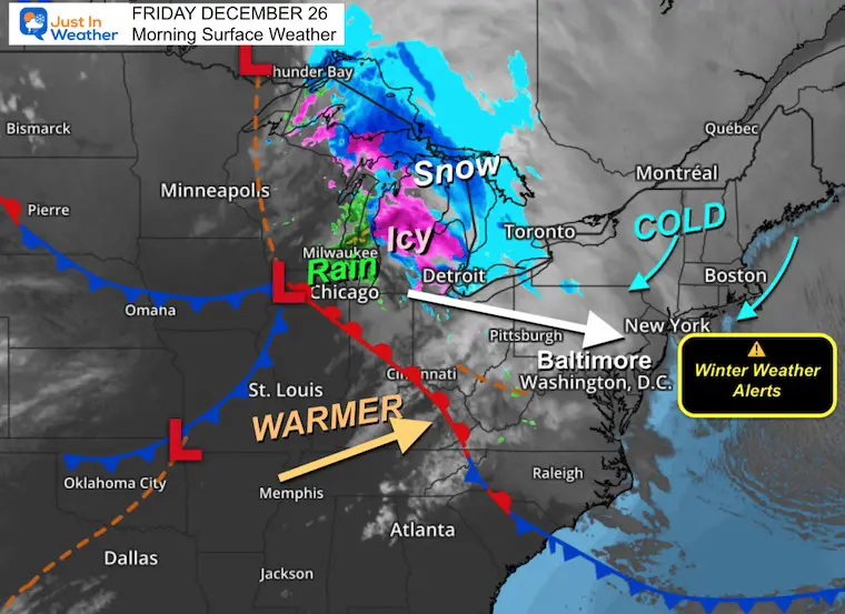
Morning Surface Weather
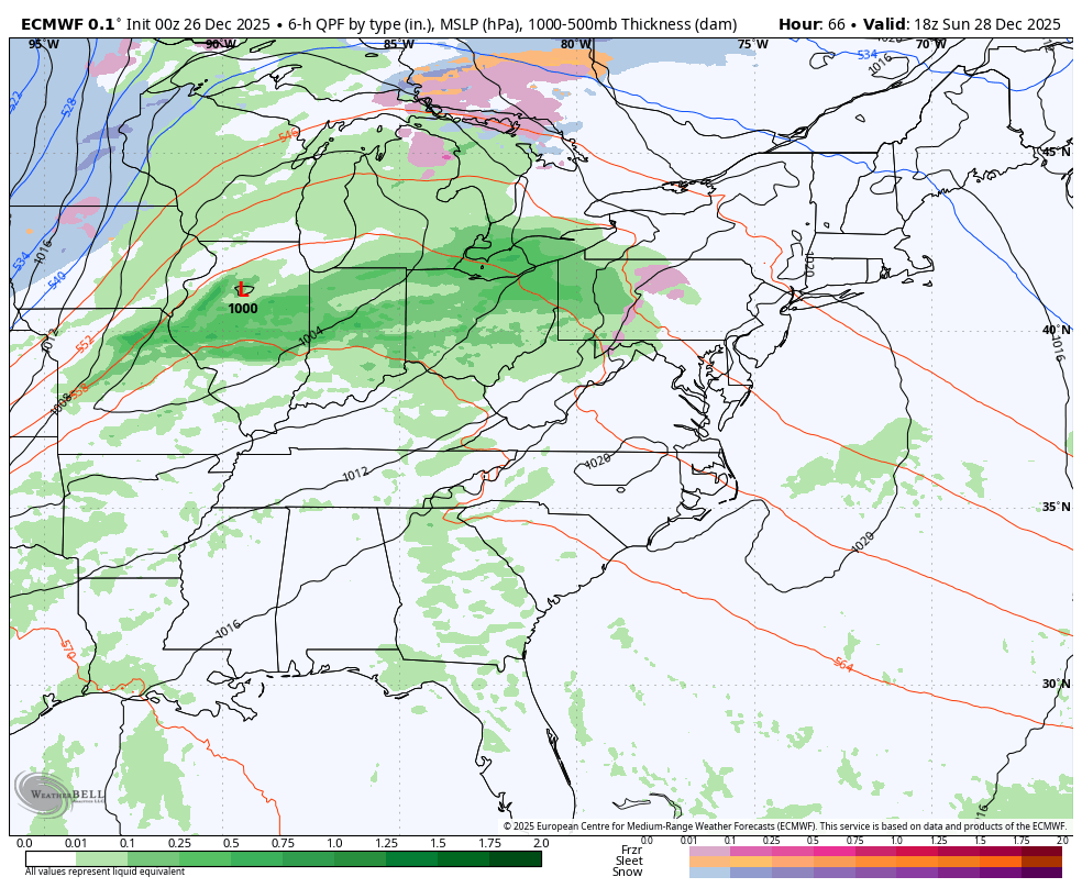
Low Pressure near Chicago will be tracking along a narrow path between COLD air in New England and warmer air to the south. The transition will be right across our region.
Storm Quick View
7 AM Fri to 7 AM Sat: ECMWF Model

How Today May Play Out:
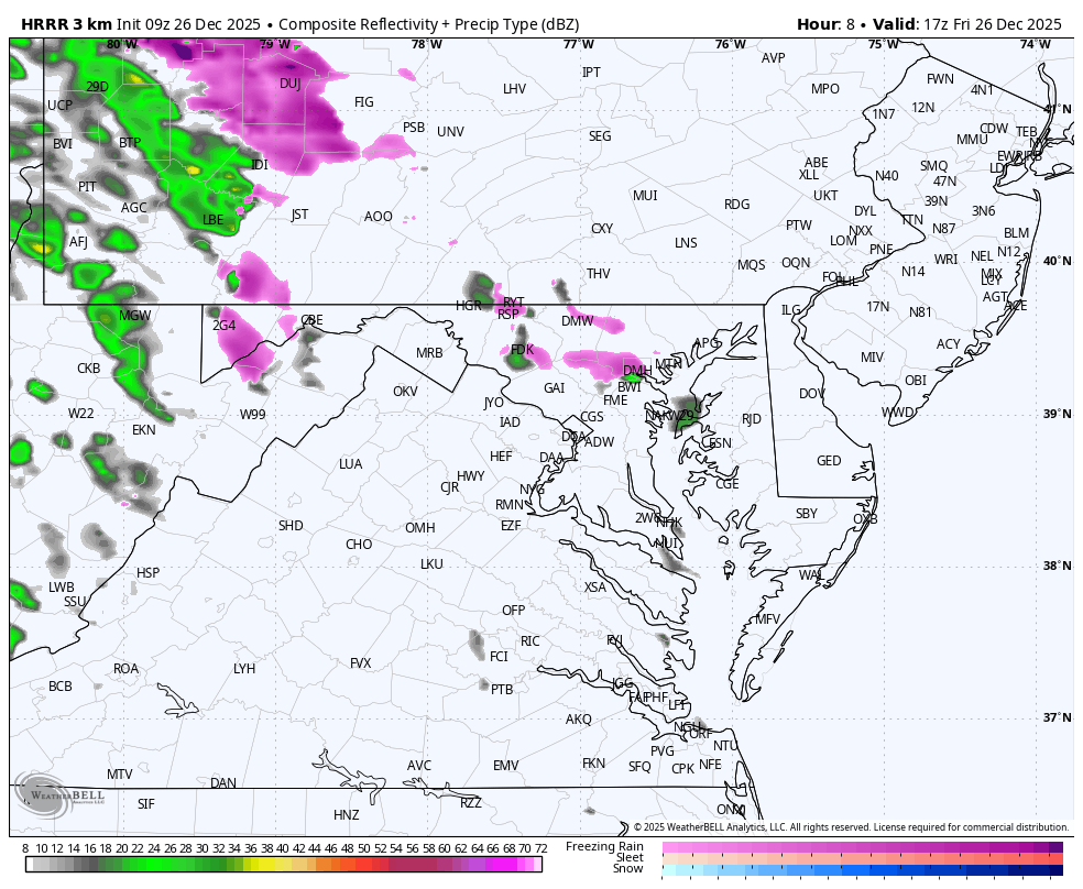
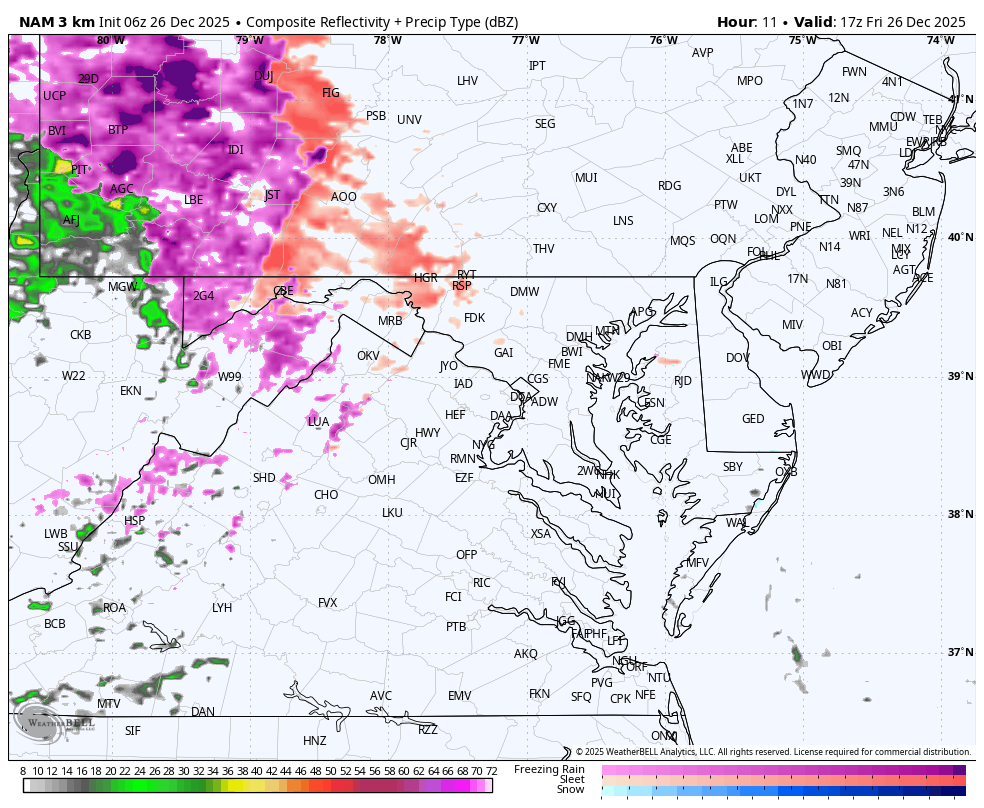
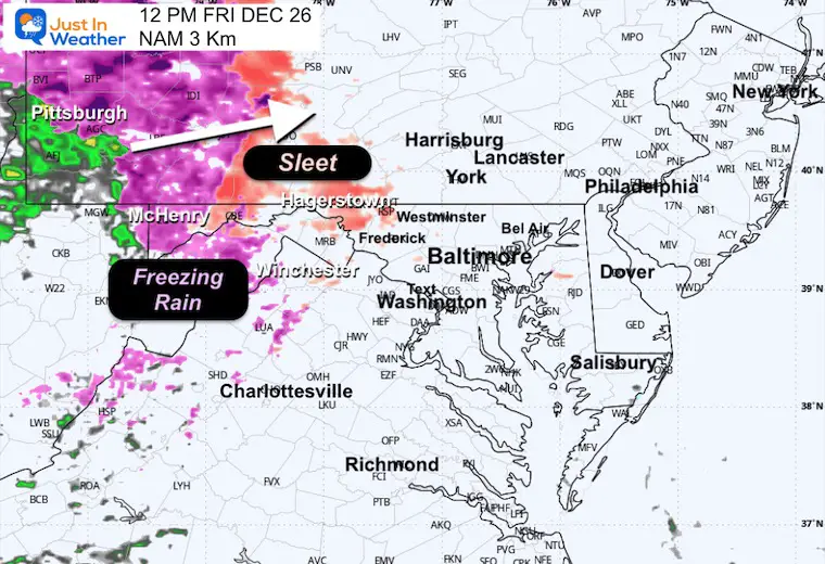
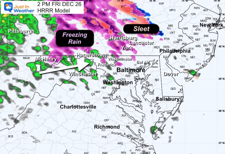
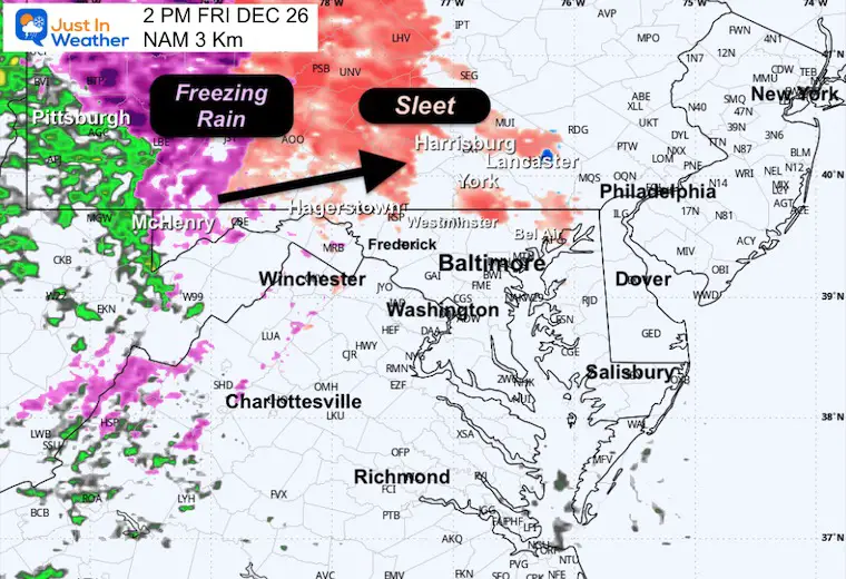
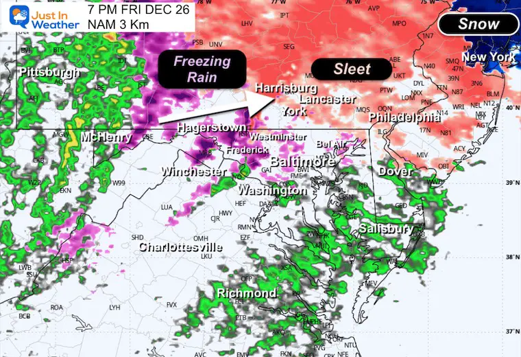
Comparing Two Short-Range Model Simulations: The HRRR and NAM 3 Km models are both not perfect, but the contrast here may help show the similarities and subtle differences:
12 PM to Midnight
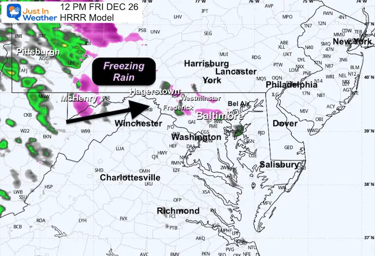
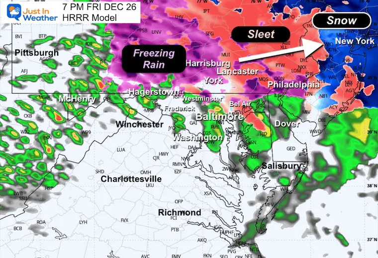
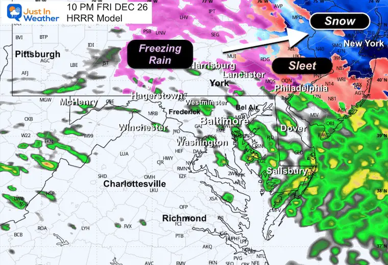
HRRR Model
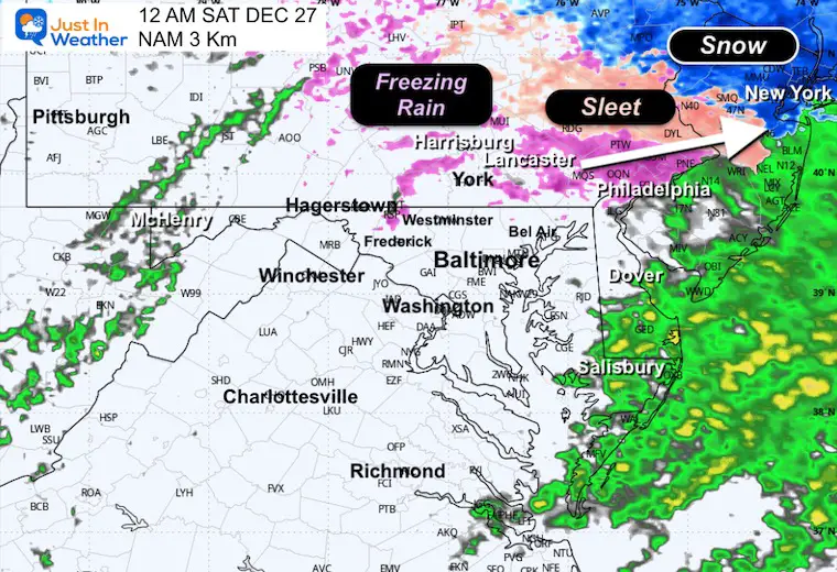
NAM 3 Km Model
Snapshots
NOON: 12 PM
Temperatures
HRRR Model
NAM 3 Km
2 PM
HRRR Model
NAM 3 Km
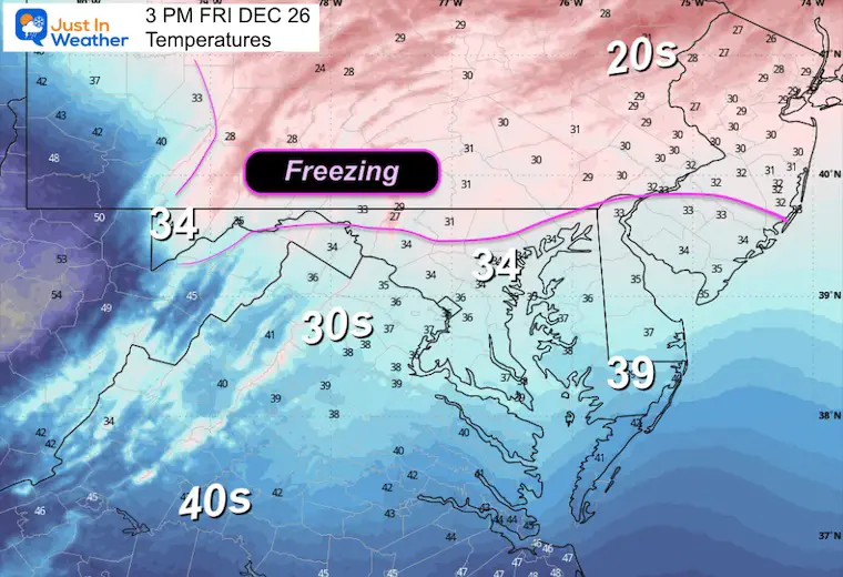
3 PM Temperatures
Mid Afternoon 5 PM
EVENING: 7 PM
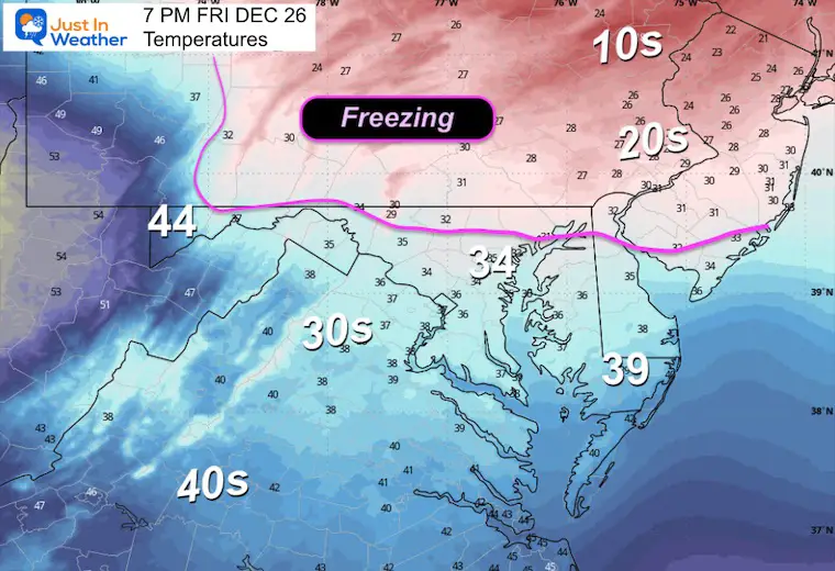
Temperature
Notice the freezing line is expected to be just north of Baltimore
HRRR Model
NAM 3 Km
TONIGHT
10 PM HRRR Model
Midnight NAM 3 Km Model
Net Results
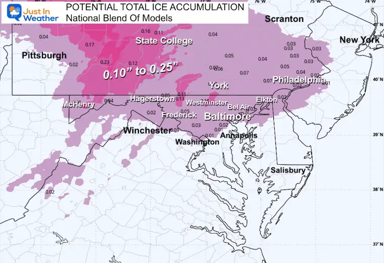
Ice Forecast
Total of 0.10” to 0.25” Near and North of the Maryland/Pennsylvania line.
Metro areas will be closer to 0.10”, so a small impact.
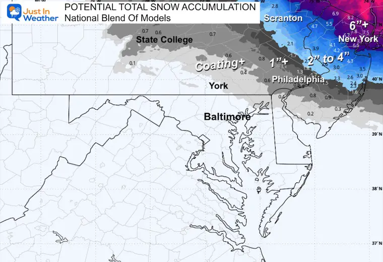
Snow Forecast
Metro New York is in line with a general 4 to 8 inches of snow. However, the Catskill Mountains and Lower Hudson Valley may get spots pushing even higher. This is the bullseye for this storm.
MOUNTAIN CAM:
WESTERN MARYLAND
Wind is still in full force in this region. A fresh coasting to few inches of snow have blanketed the region.
This webcam is positioned at The Greene Turtle Deep Creek Lake and shows Wisp Resort, including a zoomed-in view of Squirrel Cage, The Face, the terrain park, Boulder, the mountain coaster, the tubing park and a shot of McHenry Cove at Deep Creek Lake!
CLIMATE DATA: Baltimore
Yesterday: Low 31°F; High 57°F
Precipitation: Trace
Season Snow Total: 2.0″
Snow Depth: 0″
Top Wind Gust: 26 mph
TODAY December 26
Sunrise at 7:25 AM
Sunset at 4:50 PM
Normal Low in Baltimore: 28ºF
Record Low: 2ºF in 1983
Normal High in Baltimore: 45ºF
Record High: 73ºF in 1889/1964
Rainfall Deficit at BWI
* Ending 2024 = -8.00″
* Since Jan 1 = -8.39″
* We are STILL DOWN -16.39″ INCLUDING LAST YEAR
SATURDAY
This will be mostly cloudy and seasonal.
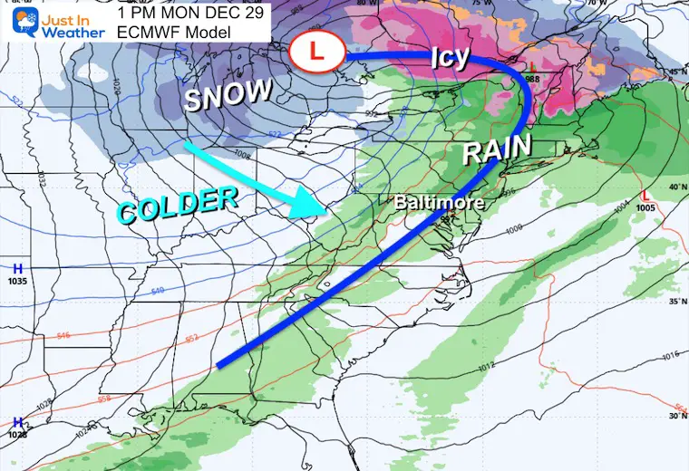
Looking Ahead: Sunday to Monday Storm
This will be the next pattern changer and will arrive a little later. A surge of warmer air with rain will arrive from Sunday to Monday. The rain may include a rumble of thunder…. on Monday.
Then temps will crash, and in the colder air, flurries will be possible on Tuesday. Another push of arctic air will arrive around the New Year.
Storm Forecast: Sunday Afternoon to Tuesday Afternoon
Monday Snapshot
Tuesday Snapshot
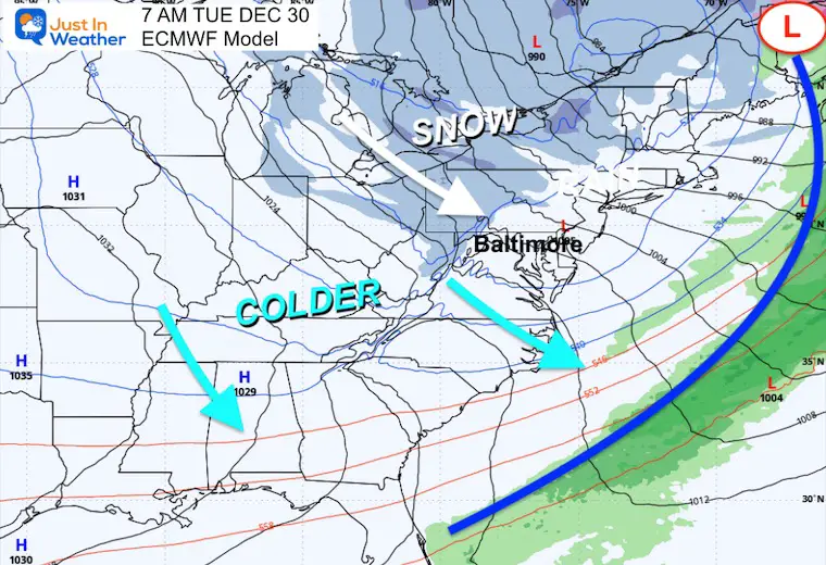
Jet Stream Forecast Monday to Thursday

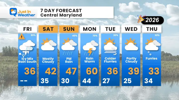
7 Day Forecast: Central Maryland
- Friday: Icy Mix, Rain South | High 36°F | 90% chance
- Saturday: Mostly Cloudy | High 42°F / Low 35°F
- Sunday: PM Rain | High 47°F / Low 30°F | 40% chance
- Monday: Rain, Warm | High 60°F / Low 44°F | 70% chance
- Tuesday: Colder, Flurries | High 36°F / Low 27°F | 30% chance
- Wednesday: Partly Cloudy | High 39°F / Low 25°F
- Thursday: Flurries | High 33°F / Low 34°F | 30% chance
Subscribe For email Alerts
FAITH IN THE FLAKES STORE
NOW OPEN FOR THE SEASON
click here

Snow Report December 14 and Grade My Forecast
In case you missed it, click this image for brief summary of the final snow totals from the last event.

Snow Report December 5 to 6 and Grade My Forecast
In case you missed it, click this image for brief summary of the final snow totals from the last event.

My Winter Outlook For Above-Average Snow
Click here for the full report

La Niña Advisory
This was issued October 9, as expected: A weak and short-lived event to start winter may play a different role this winter.

In Case You Missed It
Woolly Bear Caterpillar Winter Folklore
These are NOT all the same caterpillar!

Winter Outlook From 2 Farmers’ Almanacs

STEM Assemblies/In School Fields Trips Are Back
Click to see more and ‘Book’ a visit to your school

THANK YOU:
Baltimore Sun Magazine Readers’ Choice Best Of Baltimore

Maryland Trek 12 Day 7 Completed Sat August 9
UPDATED: We raised OVER $170,000 for Just In Power Kids – AND Still Collecting More
The annual event: Hiking and biking 329 miles in 7 days between The Summit of Wisp to Ocean City.
Each day, we honor a kid and their family’s cancer journey.
Fundraising is for Just In Power Kids: Funding Free Holistic Programs. I never have and never will take a penny. It is all for our nonprofit to operate.
Click here or the image to donate:

RESTATING MY MESSAGE ABOUT DYSLEXIA
I am aware there are some spelling and grammar typos and occasional other glitches. I take responsibility for my mistakes and even the computer glitches I may miss. I have made a few public statements over the years, but if you are new here, you may have missed it: I have dyslexia and found out during my second year at Cornell University. It didn’t stop me from getting my meteorology degree and being the first to get the AMS CBM in the Baltimore/Washington region. One of my professors told me that I had made it that far without knowing and to not let it be a crutch going forward. That was Mark Wysocki, and he was absolutely correct! I do miss my mistakes in my own proofreading. The autocorrect spell check on my computer sometimes does an injustice to make it worse. I can also make mistakes in forecasting. No one is perfect at predicting the future. All of the maps and information are accurate. The ‘wordy’ stuff can get sticky. There has been no editor who can check my work while writing and to have it ready to send out in a newsworthy timeline. Barbara Werner is a member of the web team that helps me maintain this site. She has taken it upon herself to edit typos when she is available. That could be AFTER you read this. I accept this and perhaps proves what you read is really from me… It’s part of my charm. #FITF
Please share your thoughts and best weather pics/videos, or just keep in touch via social media.


