


December 22 Light Snow Or Mix Before A Mild Christmas Holiday Then Another Arctic Blast To End The Year
Monday, December 22, 2025 Today will be the coldest day of the week. We continue to be on the edge of a big warm-up in the middle of the nation,…
Tuesday, December 23, 2025
We got that band of slushy snow early this morning, on the trend we’ve discussed here, it arrived a little faster, which is important as we go forward, to freezing rain expected on Friday.
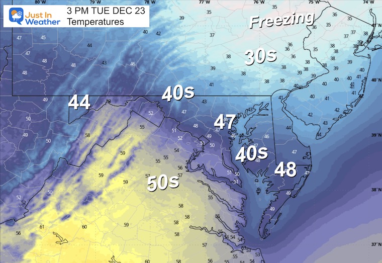
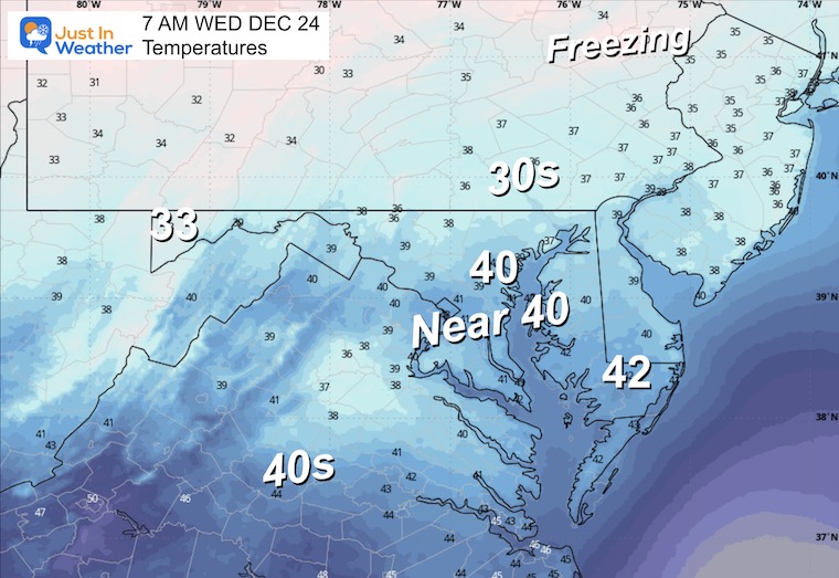
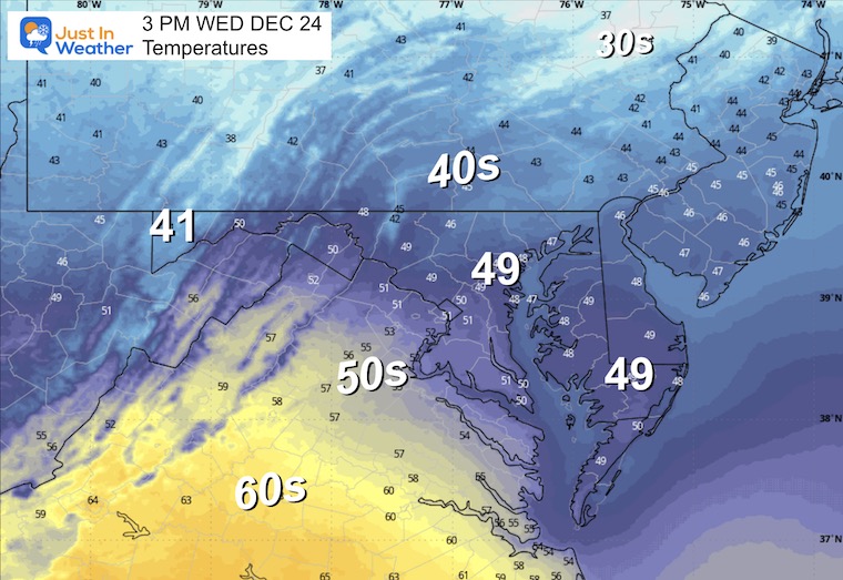
In between, warmer temps will flow in for Christmas Eve and Day.
There is snow concern today if you are driving north to the Poconos or past Philadelphia to New York and New England.
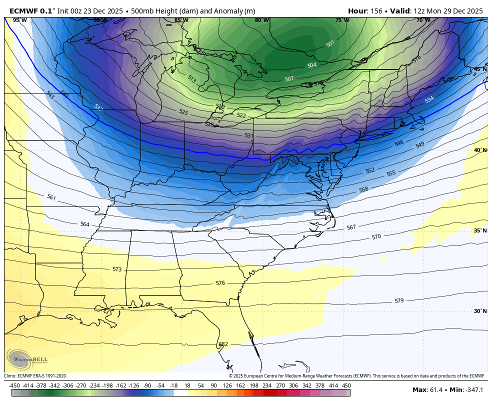
Looking ahead to next week, the block in the North Atlantic is bucking model suggestions as the guidance readjusts to show the intrusion of arctic air next week.
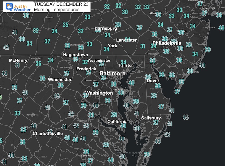
This was the post I shared showing snow at 5:15 AM, plus viewer reports. So it happened and is already improving. But you might see snow on the ground in the northern parts of Maryland to PA. The roads are likely slushy or have already thawed.
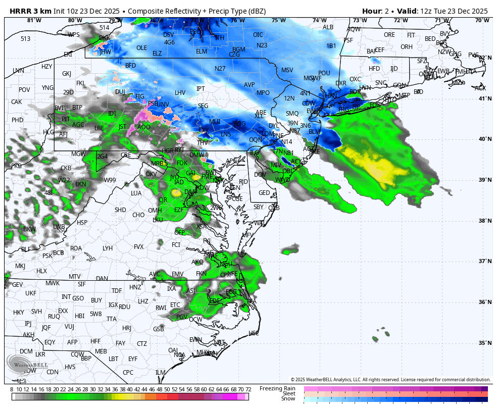
Snow is falling across Northeastern Maryland through Southern Pennsylvania and the Poconos. This is expanding to the Northeast, and it will snow for a few hours across Philadelphia to New York and New England.
The cities can expect a coating to 1 inch, with higher amounts in the Northwest suburbs. Treated roads should be OK or slushy.
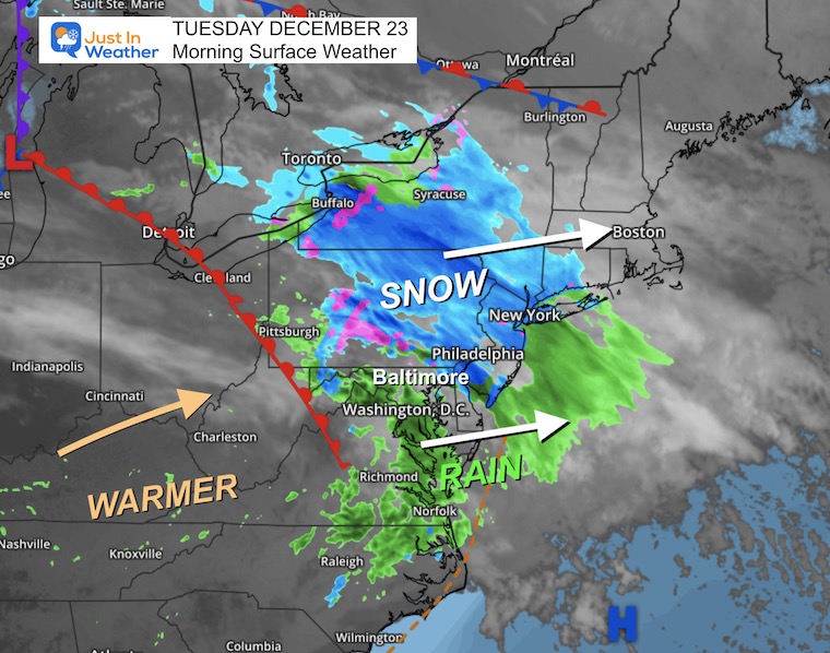
Snow will last through noon near Metro New York City.
Snow will last into the afternoon and evening for New England.
WESTERN MARYLAND ‘Rain’
Wind is still in full force in this region. A fresh coasting to few inches of snow has blanketed the region.
This webcam is positioned at The Greene Turtle Deep Creek Lake and shows Wisp Resort, including a zoomed-in view of Squirrel Cage, The Face, the terrain park, Boulder, the mountain coaster, the tubing park and a shot of McHenry Cove at Deep Creek Lake!
Yesterday: Low 18°F; High 46°F
Precipitation: 0.00″
Season Snow Total: 2.0″
Snow Depth: 0″
Top Wind Gust: 14 mph
Sunrise at 7:24 AM
Sunset at 4:48 PM
Normal Low in Baltimore: 28ºF
Record Low: 0ºF in 1960
Normal High in Baltimore: 46ºF
Record High: 69ºF in 1990
Rainfall Deficit at BWI
Sign up and be the first to know!

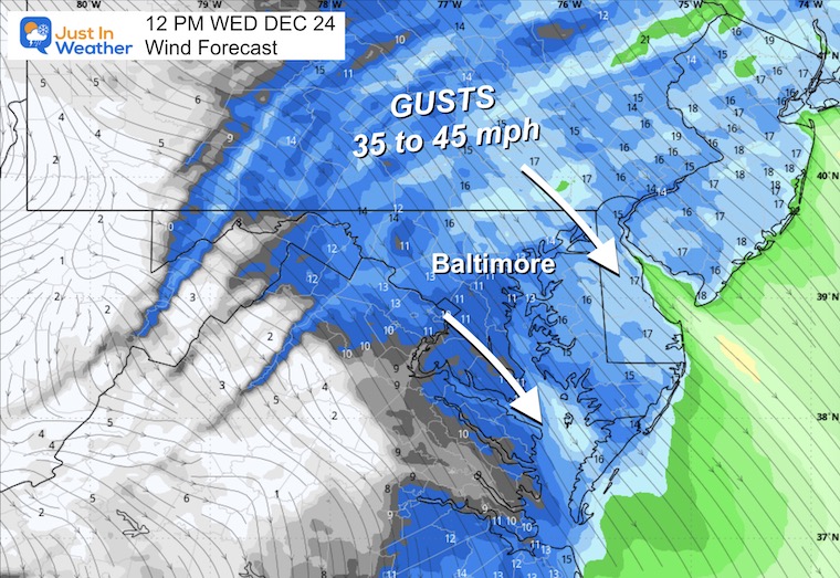
This will be a mild day with more wind in the morning. Then, as the wind fades in the afternoon, clouds will be on the increase.
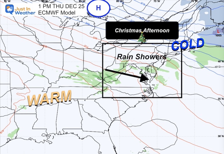
Scattered showers will break out in the transition zone between the warm central US and colder New England.
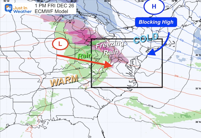
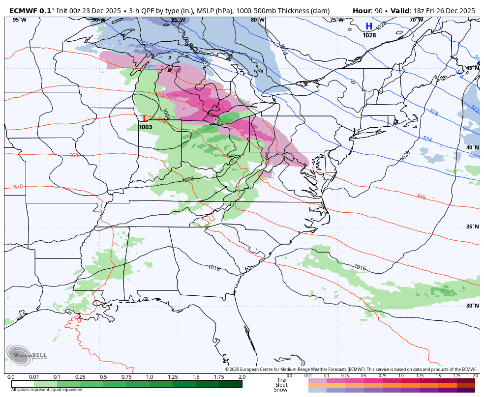
Friday Icy Mix! This is mostly likely to be a region-wide freezing rain event. As of now, the impulse is forecast to arrive in the afternoon through the evening.
I am hedging my bet that the trend for systems to arrive earlier may make this a morning event, and icy travel is a real concern.
Blocking High in New England will help to hold the cold at the surface into the Mid-Atlantic as rain will be forced to overrun… This is the setup for warmer clouds and cold ground that leads to icy weather.
The icy weather will give way to a warm up, then a strong cold front will arrive with a line of rain and maybe thunder on Sunday. This will be followed by a sharp cool down with arctic air next week.
After a warm day, this line of rain will mark the arrival of the next arctic push.
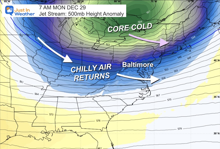
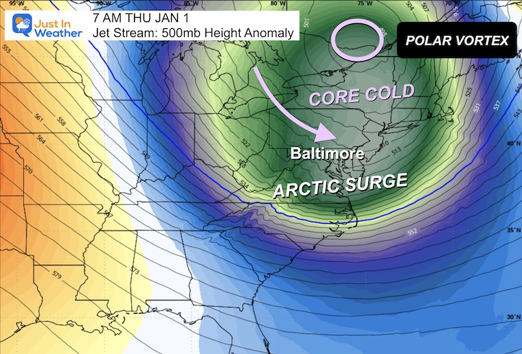
Big Changes with the return of arctic air before and after the New Year.
Next Monday will be the first impulse, then a much stronger push on New Year’s Day.
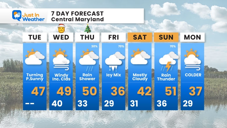
Tuesday: Turning partly sunny.
Wednesday (Christmas Eve): Windy with increasing clouds.
Thursday (Christmas): Rain shower possible (30%)
Friday: Icy mix; Most Likely Freezing Rain (70%)
Saturday: Mostly cloudy
Sunday: Rain and possibly thunder (70%)
Monday: COLDER
Subscribe for eMail Alerts
Sign up and be the first to know!
In case you missed it, click this image for brief summary of the final snow totals from the last event.

In case you missed it, click this image for brief summary of the final snow totals from the last event.

Click here for the full report

This was issued October 9, as expected: A weak and short-lived event to start winter may play a different role this winter.

These are NOT all the same caterpillar!


Click to see more and ‘Book’ a visit to your school


The annual event: Hiking and biking 329 miles in 7 days between The Summit of Wisp to Ocean City.
Each day, we honor a kid and their family’s cancer journey.
Fundraising is for Just In Power Kids: Funding Free Holistic Programs. I never have and never will take a penny. It is all for our nonprofit to operate.
Click here or the image to donate:

I am aware there are some spelling and grammar typos and occasional other glitches. I take responsibility for my mistakes and even the computer glitches I may miss. I have made a few public statements over the years, but if you are new here, you may have missed it: I have dyslexia and found out during my second year at Cornell University. It didn’t stop me from getting my meteorology degree and being the first to get the AMS CBM in the Baltimore/Washington region. One of my professors told me that I had made it that far without knowing and to not let it be a crutch going forward. That was Mark Wysocki, and he was absolutely correct! I do miss my mistakes in my own proofreading. The autocorrect spell check on my computer sometimes does an injustice to make it worse. I can also make mistakes in forecasting. No one is perfect at predicting the future. All of the maps and information are accurate. The ‘wordy’ stuff can get sticky. There has been no editor who can check my work while writing and to have it ready to send out in a newsworthy timeline. Barbara Werner is a member of the web team that helps me maintain this site. She has taken it upon herself to edit typos when she is available. That could be AFTER you read this. I accept this and perhaps proves what you read is really from me… It’s part of my charm. #FITF