Monday, December 22, 2025
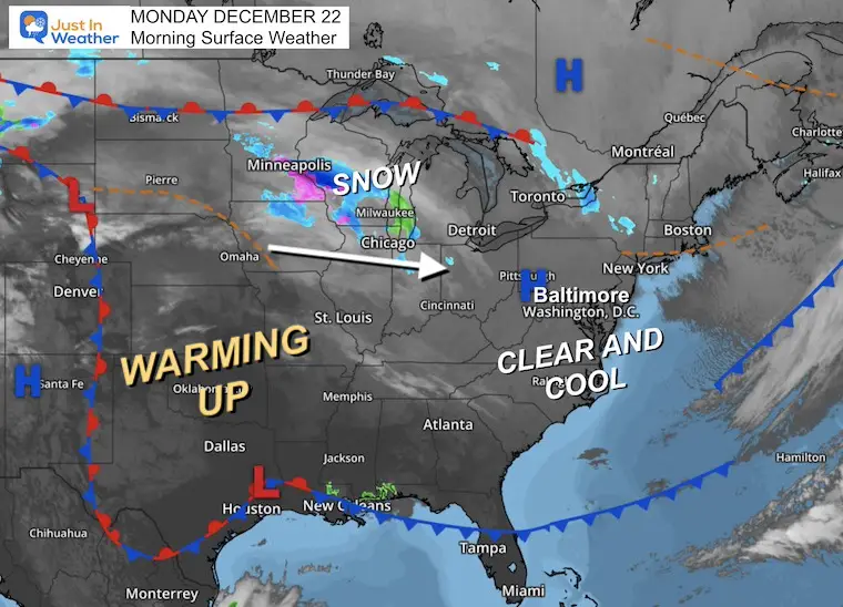
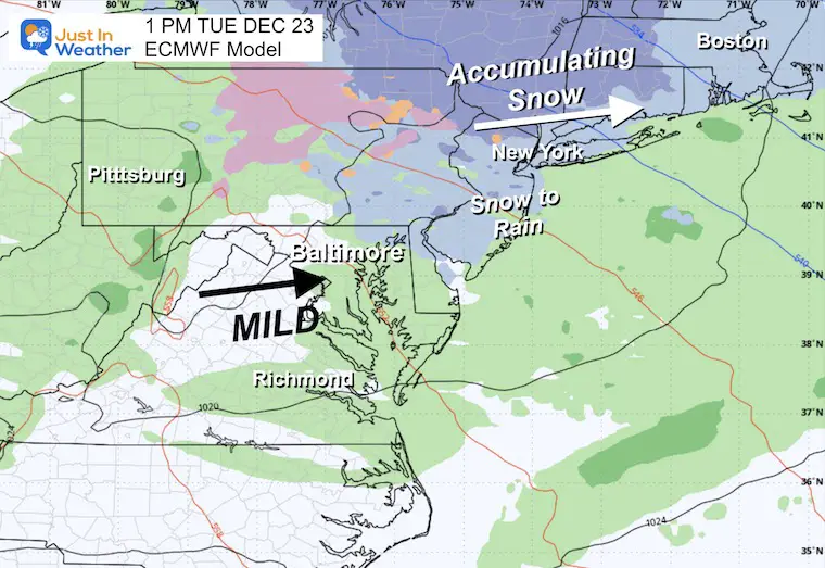
Today will be the coldest day of the week. We continue to be on the edge of a big warm-up in the middle of the nation, and winter hanging on in New England. The net result has us in the transition zone. That will put a light snow or mix on display Tuesday morning, while some accumulating snow will affect travel through the Poconos, New York, and New England.
Christmas looks mild, then another push of cold will include more icy mix to watch later this week.
On the bright side, today is the first FULL DAY of winter with daylight 2 seconds longer than yesterday!
HEADLINES
- Today the coolest day of the week
- Tuesday light snow or mix in the morning, then mild
- Warmer Christmas Holiday
- Friday may bring freezing rain
- Arctic air arrives next week BEFORE the New Year
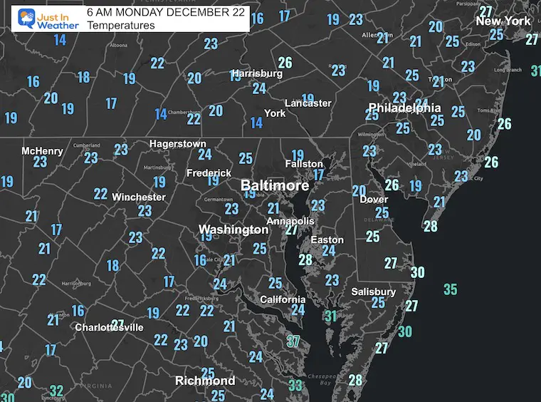
Morning Temperatures
Morning Surface Weather
High pressure is in control today with sun and light wind.
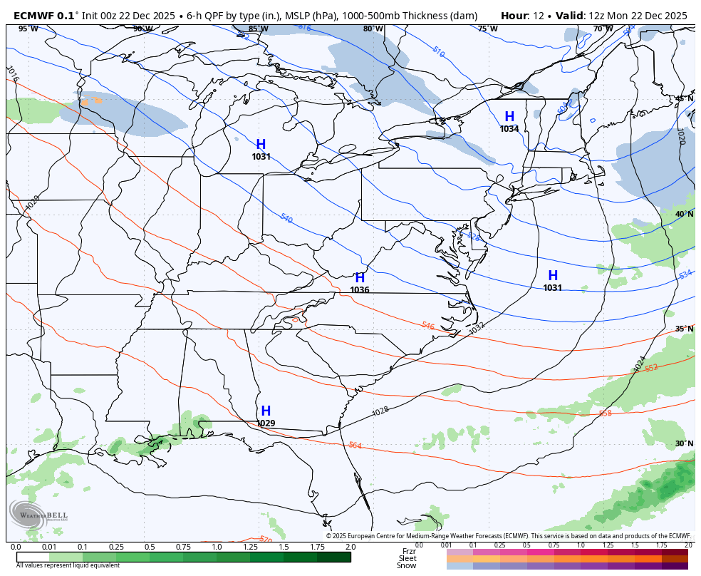
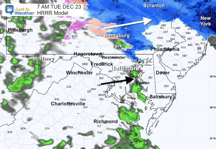
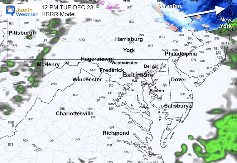
The next system will race across the Great Lakes to the Northeast. This is what we are tracking for possible light snow arriving by daybreak tomorrow.
Stormy Quick View: Monday Morning to Tuesday Evening
Snapshots
Tuesday Morning
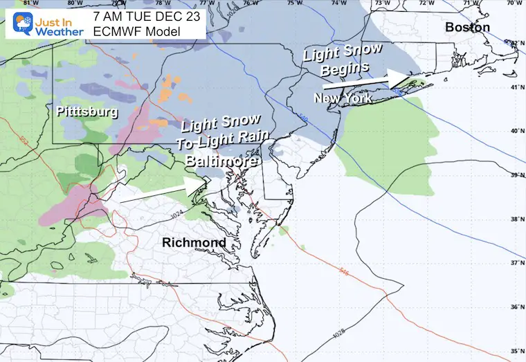
Brief light mix of snow and rain for us, but watch for more snow to our north.
Tuesday Evening
Mild locally, but accumulating impact snow expected for the New York suburbs through New England. This includes Boston.
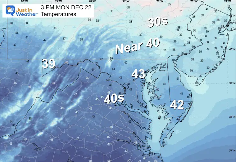
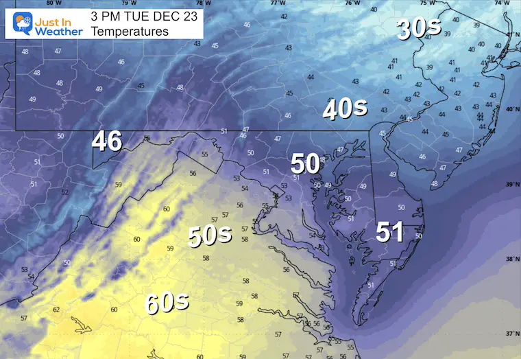
Afternoon Temperatures
MOUNTAIN CAM:
WESTERN MARYLAND SNOW
Wind is still in full force in this region. A fresh coasting to few inches of snow has blanketed the region.
This webcam is positioned at The Greene Turtle Deep Creek Lake and shows Wisp Resort, including a zoomed-in view of Squirrel Cage, The Face, the terrain park, Boulder, the mountain coaster, the tubing park and a shot of McHenry Cove at Deep Creek Lake!
CLIMATE DATA: Baltimore
Yesterday: Low 27°F; High 48°F
Precipitation: 0.00″
Season Snow Total: 2.0″
Snow Depth: 0″
Top Wind Gust: 32 mph
TODAY December 22
Sunrise at 7:23 AM
Sunset at 4:48 PM
Normal Low in Baltimore: 28ºF
Record Low: 4ºF in 1960 & 1989
Normal High in Baltimore: 46ºF
Record High: 71ºF in 2013
Rainfall Deficit at BWI
- Ending 2024 = -8.00″
- Since Jan 1 = -7.95″
- We are STILL DOWN -15.95″ INCLUDING LAST YEAR
FAITH IN THE FLAKES STORE
NOW OPEN FOR THE SEASON
click here

TUESDAY
Light mixed precipitation develops overnight. This may include a light snow and rain mix at daybreak, then temperatures increase.
The concern will be for accumulating snow northward through Pennsylvania and metro New York.
Radar Simulation Midnight to 4 PM

Snapshots
6 AM

7 AM
Morning Temperatures

Noon
Afternoon Temperatures
Looking Ahead: Friday to Sunday
- The next weather system will again track with our region on the edge.
- There has been a trend of colder air slipping into our region, which may allow for a period of freezing rain on Friday.
- Then a weekend warm-up ahead of the next push of cold air.
- This model shows freezing rain developing during the day. I’ve sped up the process with the expectation of that icy mix in the morning.
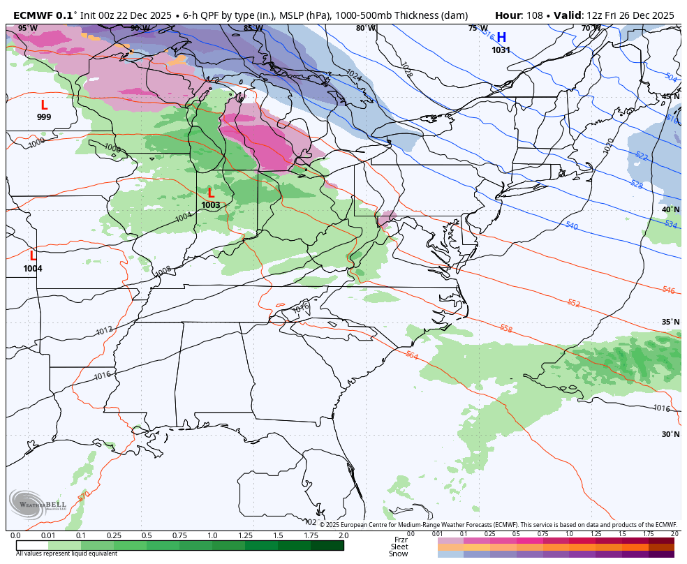
Jet Stream Friday to Next Monday
- While the middle of the nation will experience a large ridge and unseasonal warm up, I expect we will remain active on the edge of the influence in a battle zone.
- Following the rain event, Sunday will be one more push of arctic air worth watching BEFORE the end of the year.
- That cold shot will arrive just beyond our 7-day outlook shown below.

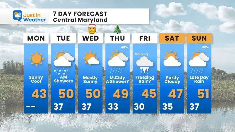
7 Day Forecast
Monday: Sunny and cool.
Tuesday: AM ‘mixed’ showers.
Christmas Eve: Mostly sunny.
Christmas Day: Mostly cloudy, a shower possible (40%).
Friday: Morning freezing rain possible, then mild.
Saturday: Partly cloudy.
Sunday: Late-day rain (60%) ahead of the next cool down.
Subscribe for eMail Alerts
Snow Report December 14 and Grade My Forecast
In case you missed it, click this image for brief summary of the final snow totals from the last event.

Snow Report December 5 to 6 and Grade My Forecast
In case you missed it, click this image for brief summary of the final snow totals from the last event.

My Winter Outlook For Above-Average Snow
Click here for the full report

La Niña Advisory
This was issued October 9, as expected: A weak and short-lived event to start winter may play a different role this winter.

In Case You Missed It
Woolly Bear Caterpillar Winter Folklore
These are NOT all the same caterpillar!

Winter Outlook From 2 Farmers’ Almanacs

STEM Assemblies/In School Fields Trips Are Back
Click to see more and ‘Book’ a visit to your school

THANK YOU:
Baltimore Sun Magazine Readers’ Choice Best Of Baltimore

Maryland Trek 12 Day 7 Completed Sat August 9
UPDATED: We raised OVER $170,000 for Just In Power Kids – AND Still Collecting More
The annual event: Hiking and biking 329 miles in 7 days between The Summit of Wisp to Ocean City.
Each day, we honor a kid and their family’s cancer journey.
Fundraising is for Just In Power Kids: Funding Free Holistic Programs. I never have and never will take a penny. It is all for our nonprofit to operate.
Click here or the image to donate:

RESTATING MY MESSAGE ABOUT DYSLEXIA
I am aware there are some spelling and grammar typos and occasional other glitches. I take responsibility for my mistakes and even the computer glitches I may miss. I have made a few public statements over the years, but if you are new here, you may have missed it: I have dyslexia and found out during my second year at Cornell University. It didn’t stop me from getting my meteorology degree and being the first to get the AMS CBM in the Baltimore/Washington region. One of my professors told me that I had made it that far without knowing and to not let it be a crutch going forward. That was Mark Wysocki, and he was absolutely correct! I do miss my mistakes in my own proofreading. The autocorrect spell check on my computer sometimes does an injustice to make it worse. I can also make mistakes in forecasting. No one is perfect at predicting the future. All of the maps and information are accurate. The ‘wordy’ stuff can get sticky. There has been no editor who can check my work while writing and to have it ready to send out in a newsworthy timeline. Barbara Werner is a member of the web team that helps me maintain this site. She has taken it upon herself to edit typos when she is available. That could be AFTER you read this. I accept this and perhaps proves what you read is really from me… It’s part of my charm. #FITF
Please share your thoughts and best weather pics/videos, or just keep in touch via social media.


