Wednesday December 17
We are about to take a break from the unusually cold start to December. The latest update now shows Baltimore’s BWI at 9.2°F below average for the month. The next two days will be closer to average and may feel warm relatively speaking.
This is ahead of our next storm, and there are a few things to focus on in the headlines.
HEADLINES
- Seasonal Temps May Feel Warm
- Thursday Morning Fog with Freezing Temps: Spots May Be Icy
- Thursday: Rain arrives in the evening; Heavy Overnight
- Friday: Morning Squall Line/T’Storm possible. High Temps will be in the morning.
- Weekend: Cooler back to near normal.
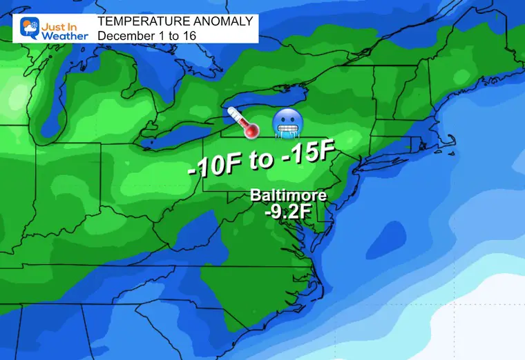
Temperature Deficit Dec 1 to 16
Baltimore is -9.2°F to date. Much of the region has been 10 to 15 degrees BELOW AVERAGE.
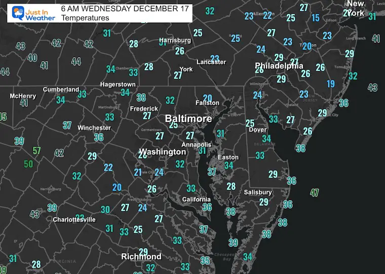
Morning Temperatures
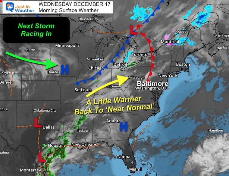
Morning Surface Weather
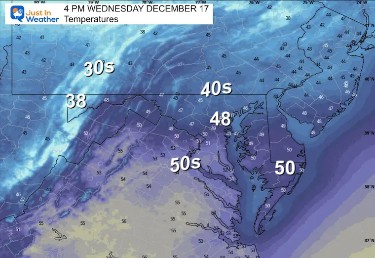
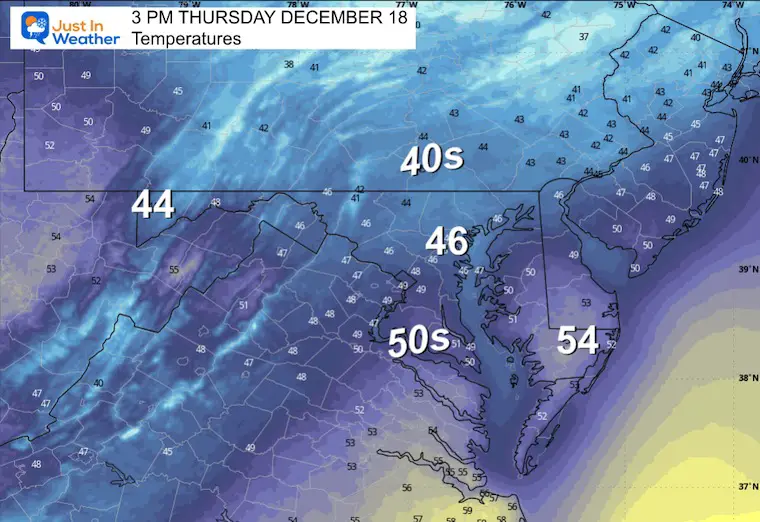
There will be a transition today with a shift of wind and temperatures warming back to near normal.
The next storm system will be racing in from the Western US.
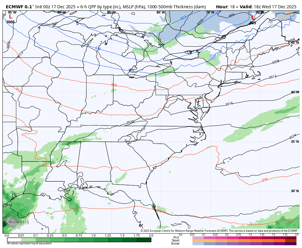
Storm Forecast Preview
Wednesday Afternoon to Friday Night
Temperatures will warm ahead of the storm. Rain arrives Thursday evening, heavy overnight, and may culminate with a storm line and possible thunder early Friday morning.
Afternoon Temperatures
MOUNTAIN CAM:
WESTERN MARYLAND SNOW
This webcam is positioned at The Greene Turtle Deep Creek Lake and shows Wisp Resort, including a zoomed-in view of Squirrel Cage, The Face, the terrain park, Boulder, the mountain coaster, the tubing park and a shot of McHenry Cove at Deep Creek Lake!
CLIMATE DATA: Baltimore
Yesterday: Low 14F; High 36F
Precipitation:
Season Snow Total: 2.0”
Top Wind Gust: 13 mph
TODAY December 17
Sunrise at 7:20 AM
Sunset at 4:46 PM
Normal Low in Baltimore: 29ºF
Record 5ºF in 1951
Normal High in Baltimore: 47ºF
Record 68ºF in 1984
Rainfall Deficit at BWI
- Ending 2024 = -8.00”
- Since Jan 1 = 7.61”
- We are STILL DOWN -15.61” INCLUDING LAST YEAR
Subscribe for eMail Alerts
FAITH IN THE FLAKES STORE
NOW OPEN FOR THE SEASON
click here

THURSDAY
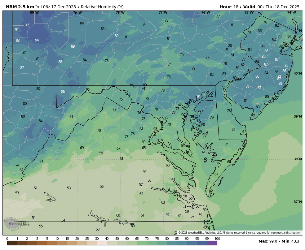
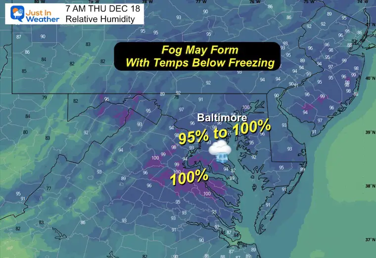
Relative Humidity Through Morning
When approaching 100%, fog may form.
Morning Snapshot
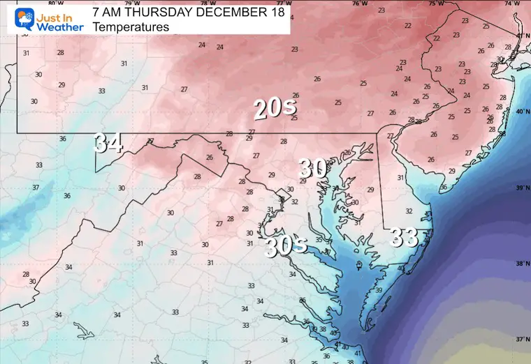
Morning Temperatures
Temps near freezing with areas of fog could form a glaze of ice in spots.
Afternoon Temperatures
STORM ARRIVING AFTER DARK
6 PM Thursday: Radar Simulation
Rain arrives from the South.
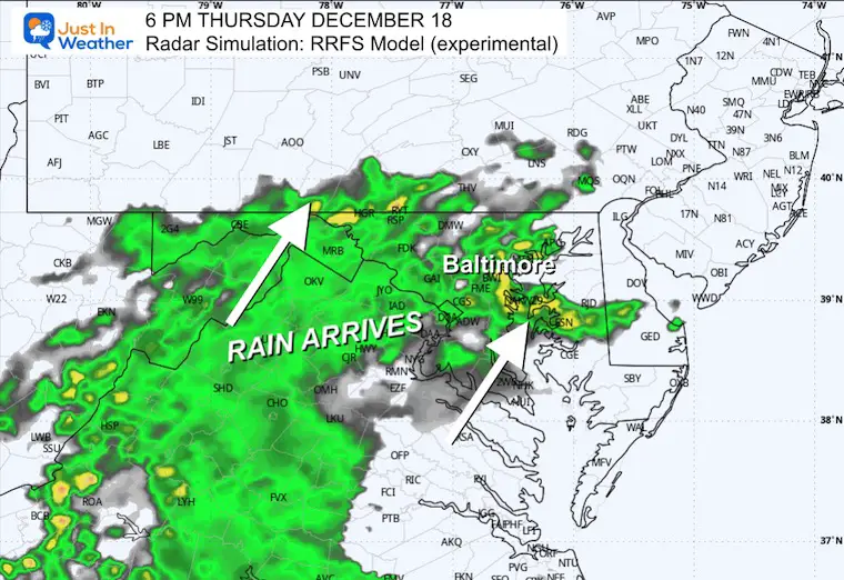
6 PM Thursday to Noon Friday
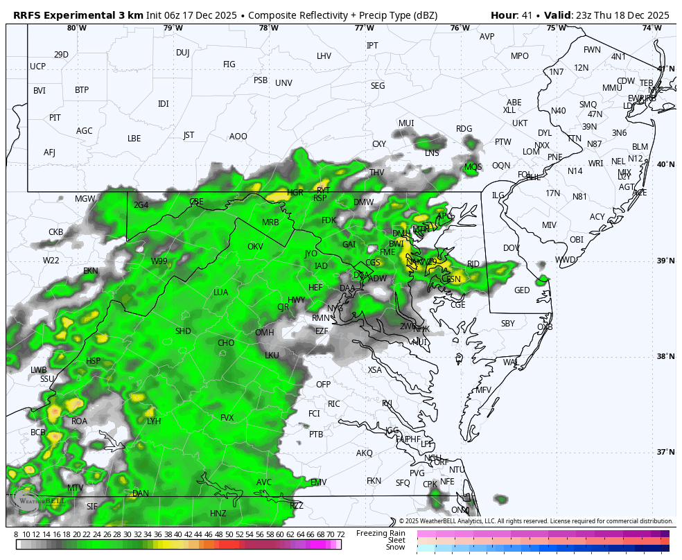
Rain will be heavy at times overnight, culminating with the cold front Friday morning.
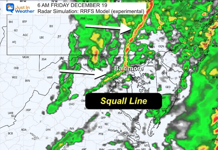
This squall line may have thunder and high winds.
6 AM Friday
The line of heavy rain and gusty winds will pass through Central Maryland before sunrise.
High Temperatures will be in the morning, then turning colder.
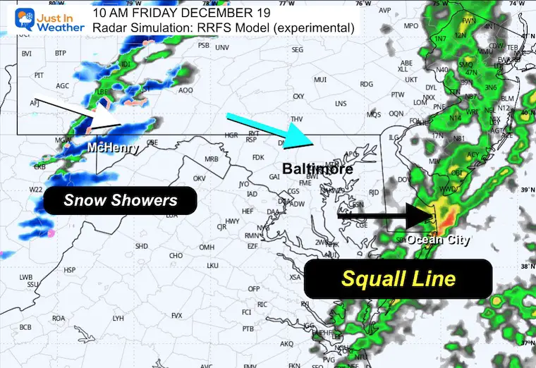
10 AM Friday
As the squall line reaches the beaches, snow will return with a few coating to a couple of inches in the mountains.
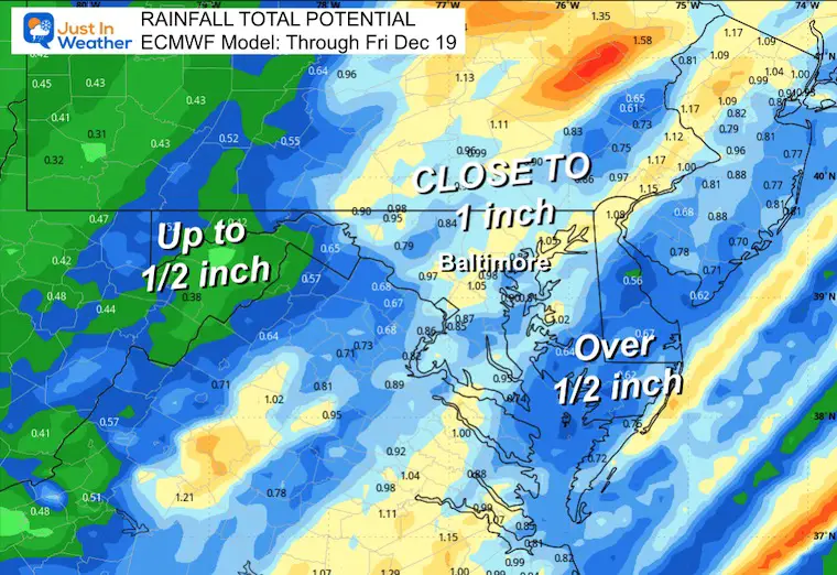
RAINFALL TOTAL POTENTIAL
Much of the region will get ‘close’ to 1 inch of rain.
This will wash away lot of snow and road salt.
Looking Later In The Week
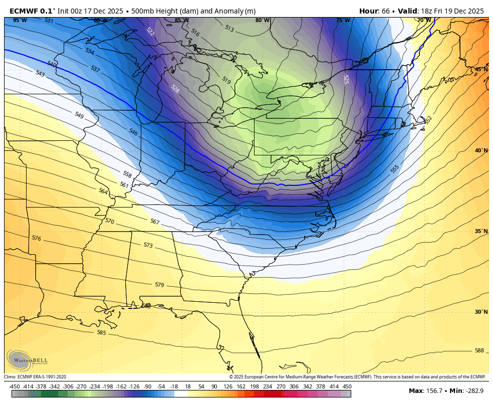
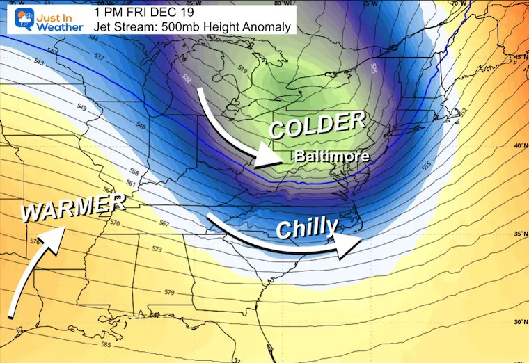
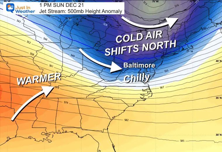
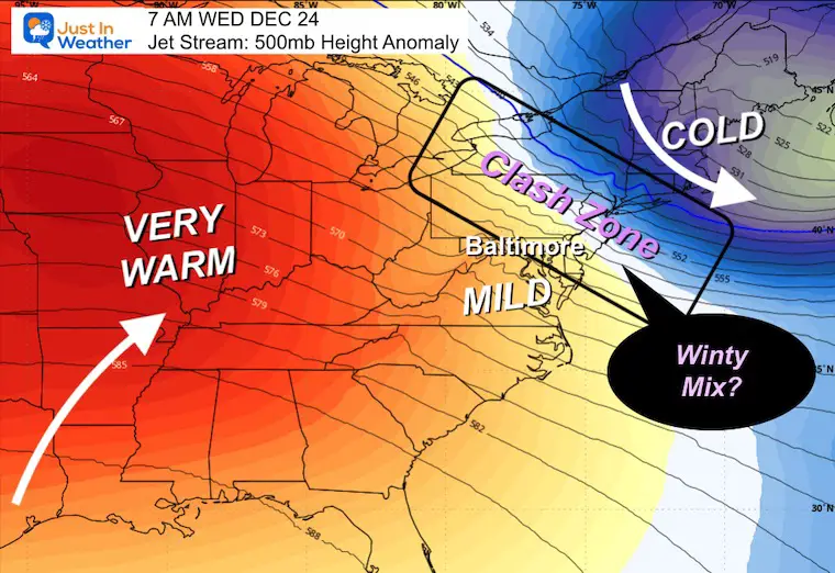
Jet Stream Forecast Friday to Christmas Eve
The core cold air will pass through Friday and then a less intense wave on Sunday. Next week a push of warm air will surge into the middle of the nation. We will be on the edge Christmas Eve.
FRIDAY
Colder air flows in behind the storm line.
SUNDAY
The next Cold Pocket/Pattern Passing North.
CHRISTMAS EVE DAY
The clash zone between the cold in New England and the approaching warm is likely to break out as a region of overrunning precipitation. This may translate to a wintry mix.
This is more of a pattern likelihood, no specifics at this time, since it is over 1 week away.
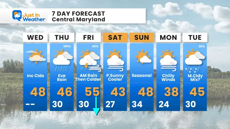
7 Day Forecast
- Today: Seasonal, Late Clouds
- Thursday = Rain By Evening; Heavy Overnight
- Friday: Morning Rain, T’storm, Then COLDER Winds
- Weekend Back Near Normal (whatever that is)
- Christmas Eve: Simply SUGGESTION A Chance For A wintry mix in the region
Subscribe for eMail Alerts
Snow Report December 14 and Grade My Forecast
In case you missed it, click this image for brief summary of the final snow totals from the last event.

Snow Report December 5 to 6 and Grade My Forecast
In case you missed it, click this image for brief summary of the final snow totals from the last event.

My Winter Outlook For Above-Average Snow
Click here for the full report

La Niña Advisory
This was issued October 9, as expected: A weak and short-lived event to start winter may play a different role this winter.

In Case You Missed It
Woolly Bear Caterpillar Winter Folklore
These are NOT all the same caterpillar!

Winter Outlook From 2 Farmers’ Almanacs

STEM Assemblies/In School Fields Trips Are Back
Click to see more and ‘Book’ a visit to your school

THANK YOU:
Baltimore Sun Magazine Readers’ Choice Best Of Baltimore

Maryland Trek 12 Day 7 Completed Sat August 9
UPDATED: We raised OVER $170,000 for Just In Power Kids – AND Still Collecting More
The annual event: Hiking and biking 329 miles in 7 days between The Summit of Wisp to Ocean City.
Each day, we honor a kid and their family’s cancer journey.
Fundraising is for Just In Power Kids: Funding Free Holistic Programs. I never have and never will take a penny. It is all for our nonprofit to operate.
Click here or the image to donate:

RESTATING MY MESSAGE ABOUT DYSLEXIA
I am aware there are some spelling and grammar typos and occasional other glitches. I take responsibility for my mistakes and even the computer glitches I may miss. I have made a few public statements over the years, but if you are new here, you may have missed it: I have dyslexia and found out during my second year at Cornell University. It didn’t stop me from getting my meteorology degree and being the first to get the AMS CBM in the Baltimore/Washington region. One of my professors told me that I had made it that far without knowing and to not let it be a crutch going forward. That was Mark Wysocki, and he was absolutely correct! I do miss my mistakes in my own proofreading. The autocorrect spell check on my computer sometimes does an injustice to make it worse. I can also make mistakes in forecasting. No one is perfect at predicting the future. All of the maps and information are accurate. The ‘wordy’ stuff can get sticky. There has been no editor who can check my work while writing and to have it ready to send out in a newsworthy timeline. Barbara Werner is a member of the web team that helps me maintain this site. She has taken it upon herself to edit typos when she is available. That could be AFTER you read this. I accept this and perhaps proves what you read is really from me… It’s part of my charm. #FITF
Please share your thoughts and best weather pics/videos, or just keep in touch via social media.


