Saturday Morning December 13, 2025
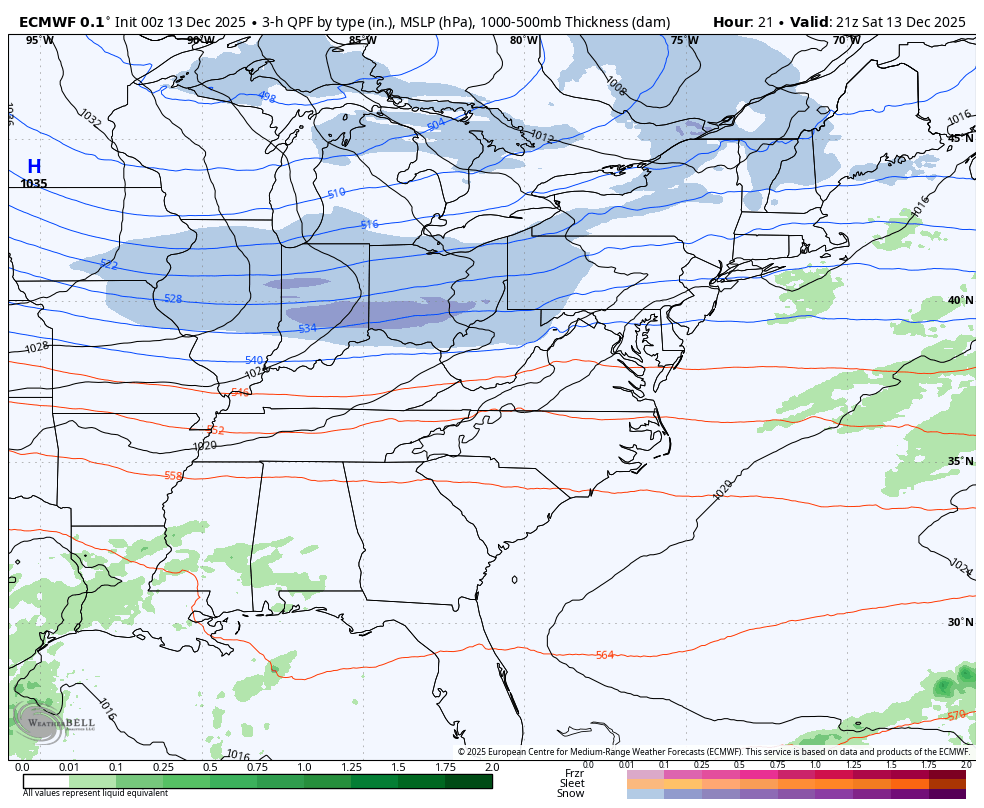
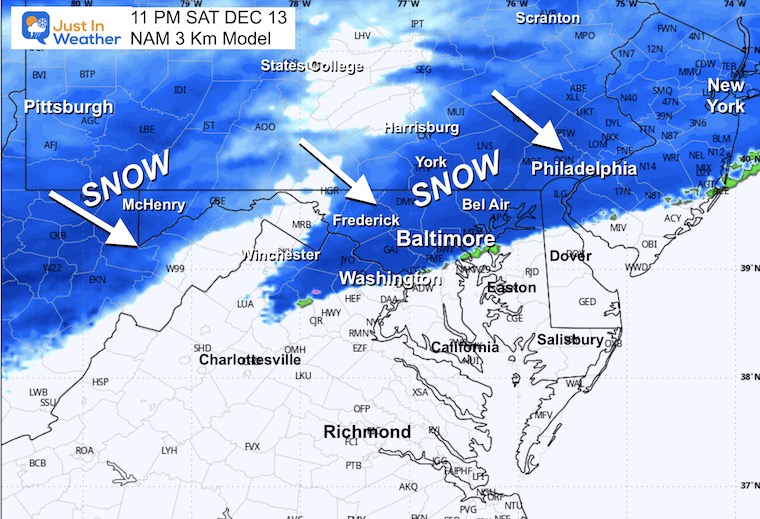
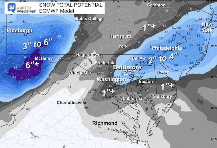
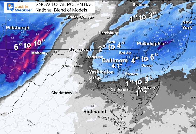
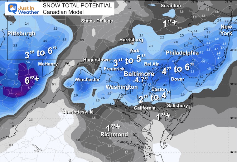
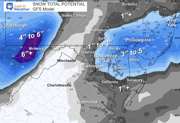
After a week of anticipation, we’re now here. The event is unfolding largely as expected, and there are two main points I want to highlight since my last update. A Winter Weather Advisory was expanded to Central Maryland and York, PA. This was expected with a general 1 to 3 inch snowfall. The timing and location of the energy aloft will pulse overnight, with some areas getting 1”/Hour snowfall rates. This places the potential to reach or exceed 4 inches across Northeastern Maryland, across Northern Delmarva, and metro Philadelphia. Southern New Jersey as well.
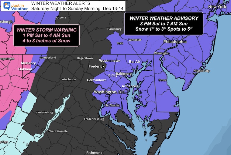
HEADLINES
- Winter Weather Advisory
- Metro Areas: Snow begins BEFORE Midnight, Ends By Sunrise
- Delmarva and the beaches will have snow in the morning
- Totals Trending to High End Of My Ranges
- Burst 1”+/Hr For Northeast Maryland, Northern Delmarva, Metro Philadelphia, Southern New Jersey
- Brutal Wind Chills Sunday to Monday Morning
- Warmer Mid Week
- Late Week Rain/T’storm
WINTER WEATHER ALERTS
This begins at 8 PM, as snow will start before midnight.
A Winter Storm Warning begins this afternoon for heavy snow in the Western Mountains.
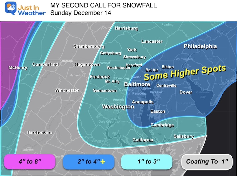
My Call For Snowfall
I repeat this below to compare to the Model and NWS Snow Maps.
New snow maps below include the timeline and 5 model snow total maps, plus the forecast maps from the National Weather Service.
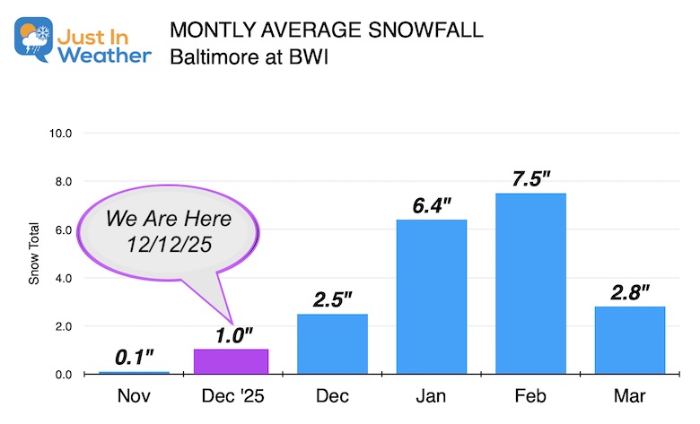
SNOW STATS
Baltimore had 1” so far this season.
If BWI measures 1.5”, that will match the average for December.
2” or more will bring the station above average for the first time since December 2017.
List of Snowy Decembers This Century
Here are the recent SNOWY December Totals this century:
- 2002 = 9.7″
- 2003 = 9.6″
- 2005 = 6.0″
- 2007 = 4.8″
- 2009 = 20.1″ *Record Month and part of Record Winter
- 2013 = 2.9″
- 2017 = 4.3″
Morning Surface Weather
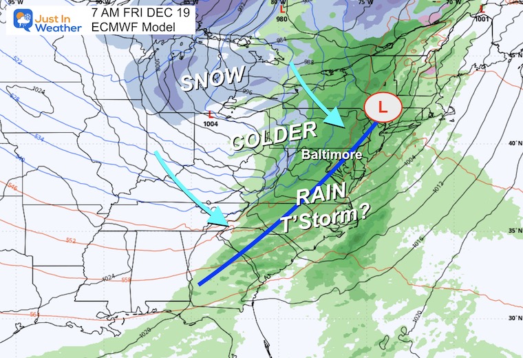
The swath of snow in the Midwest will run into the mountains. The bitterly cold air will enhance the jet stream and develop a new band of snow over metro Baltimore to Philadelphia tonight.
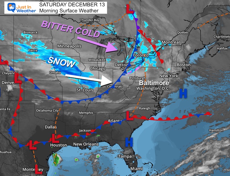
Quick View Of The Storm Track:
4 PM Today to 4 PM Sunday: ECMWF Model
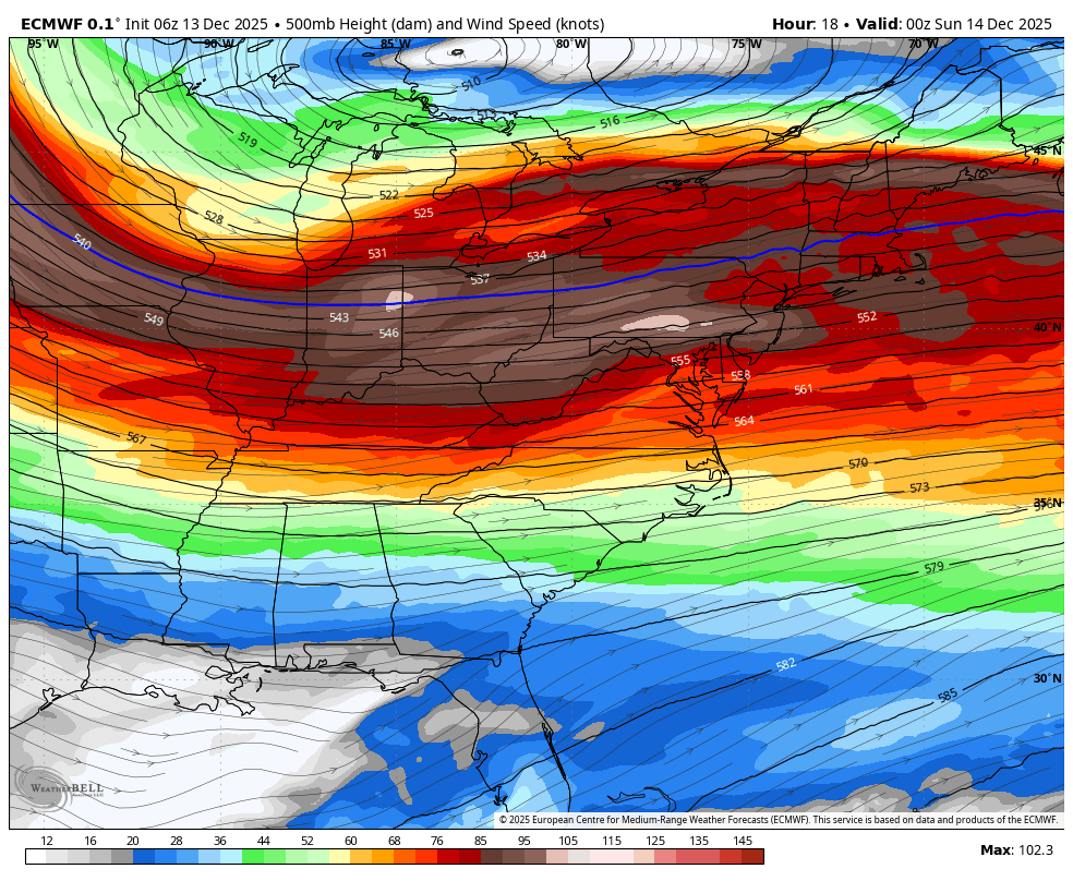
Jet Stream at 500mb/18,000 Ft 7 PM Sat to 12 PM Sun
Winds over 130 mph, with even stronger flow aloft, will enhance atmospheric lift and support snow development.
This jet streak or jet max will be combined with frontal genesis. The development of a frontal boundary that will pulse between Baltimore and Philadelphia overnight.
SNOW FOCUS
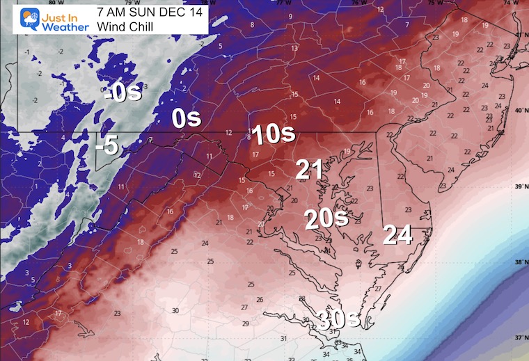
Temperatures and Wind Chill Forecast below.
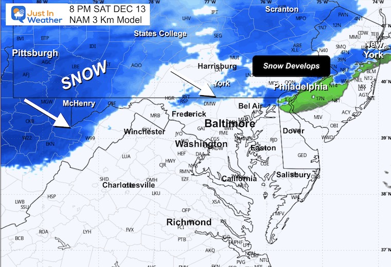
Snow will be falling in the mountains, and the leading edge of our local system will be developing snow in response to the jet stream across Southern Pennsylvania.
This will be developing and dropping to Central Maryland between 8 PM and 11 PM.
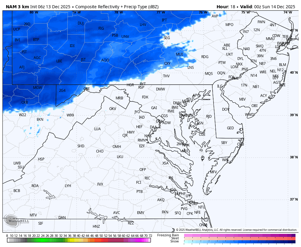
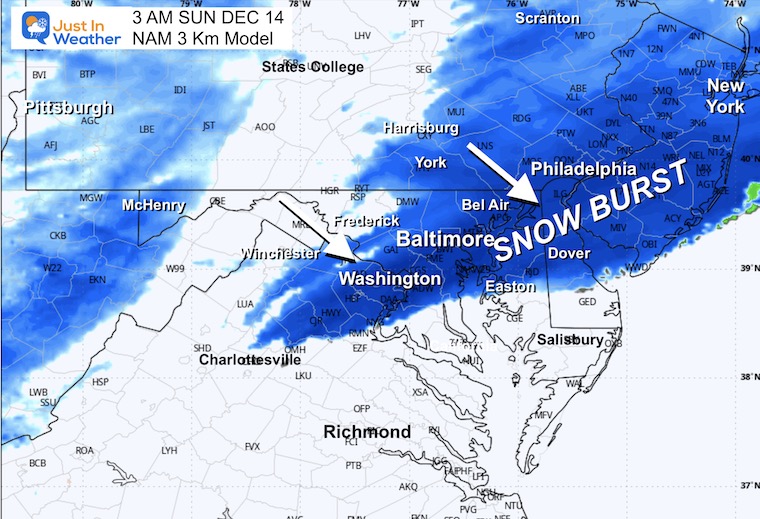
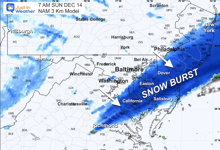
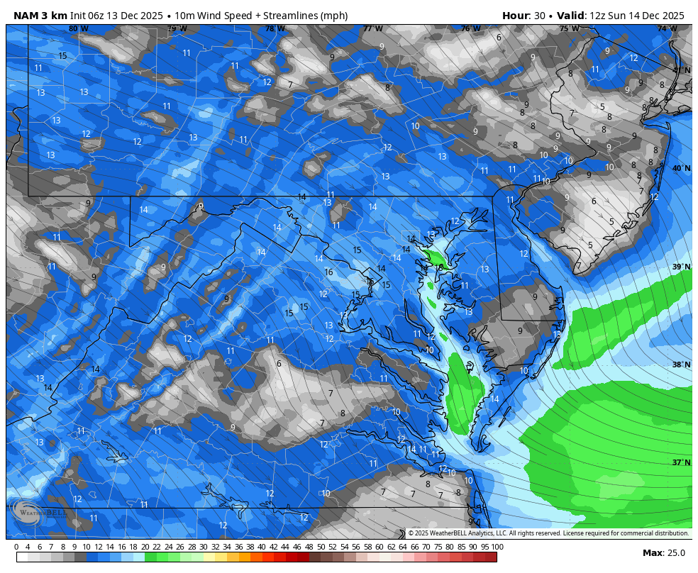
RADAR SIMULATION: NAM 3 Km Model
THIS EVENING
8 PM Radar Simulation
TONIGHT
11 PM Radar Simulation
3 AM
7 AM
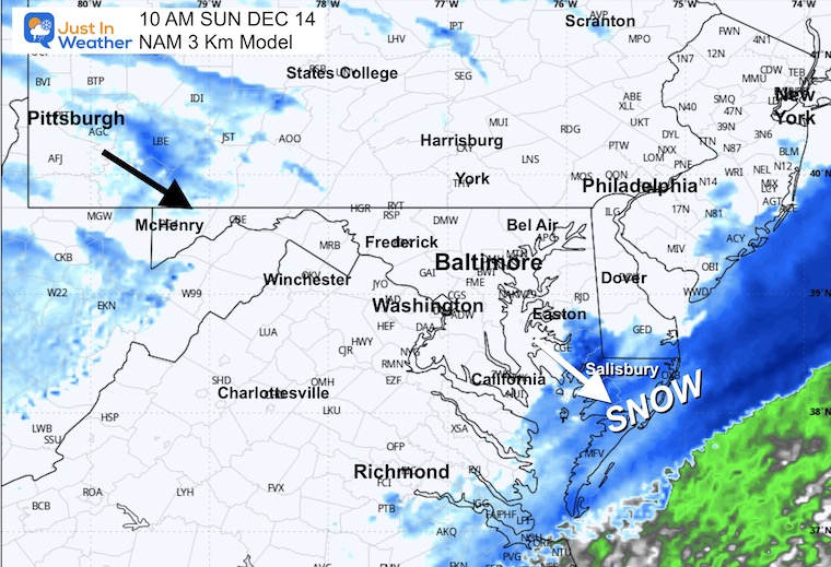
Snow should be over for metro Baltimore, but still falling in Southern Maryland and Delmarva.
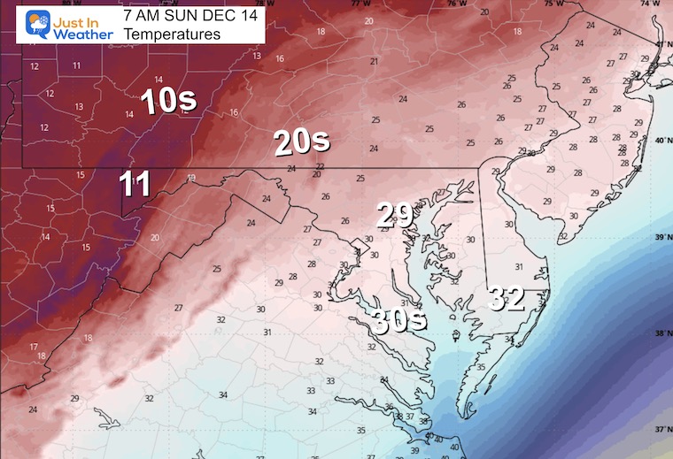
Temperatures
Wind Chills
10 AM
Snow finishing soon between Salisbury and the Beaches.
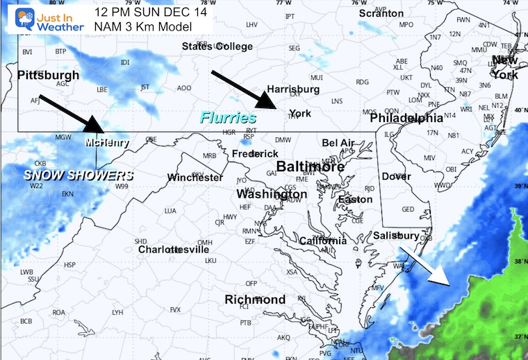
12 PM
Snow will be done for us.
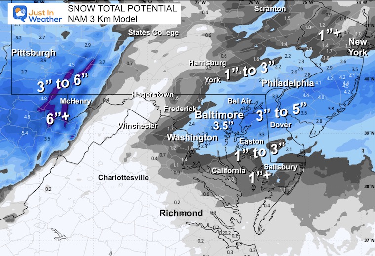
SNOW TOTAL FORECAST
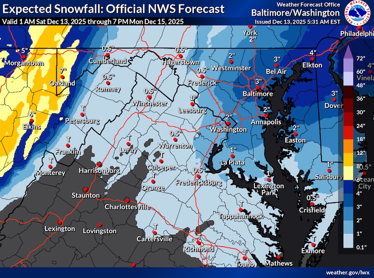
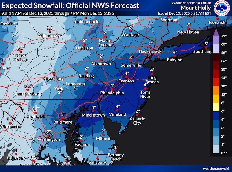
Repeating My Call To Compare To The Models
The top snow totals are likely be in Northeastern Maryland, Northern Delmarva, and metro Philadelphia to Southern New Jersey.
Snow rates 1”+/hour could boost some areas to over 4 inches.
Model Forecast Totals
NAM 3 Km
ECMWF Model
National Blend of Models
Canadian GEM
GFS
National Weather Service Forecast
Baltimore/Washington Office
Philadelphia/Mount Holly Office
Temperatures and Wind Chill Forecast below
CLIMATE DATA: Baltimore
Yesterday: Low 21F; High 37F
Precipitation: 0.00”
Snow = 0
Season Snow Total: 1.0″
Top Wind Gust: 20 mph
TODAY December 13
Sunrise at 7:18 AM
Sunset at 4:44 PM
Normal Low in Baltimore: 30ºF
Record 8ºF in 1960
Normal High in Baltimore: 48ºF
Record 72ºF in 2015
Rainfall Deficit at BWI
- Ending 2024 = -8.00”
- Since Jan 1 = 7.38”
- We are STILL DOWN -15.38” INCLUDING LAST YEAR
Subscribe for eMail Alerts
FAITH IN THE FLAKES STORE
NOW OPEN FOR THE SEASON
click here

If It Snows On Christmas: Jarrettsville Furniture Special
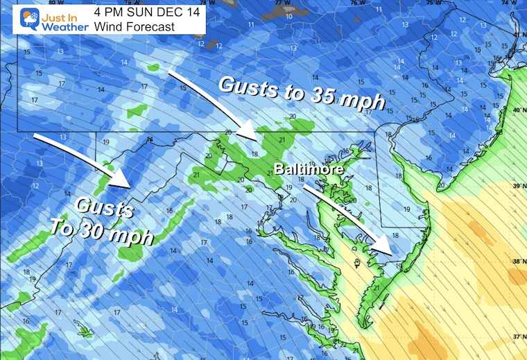
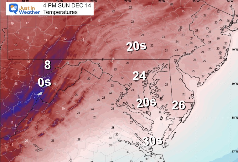
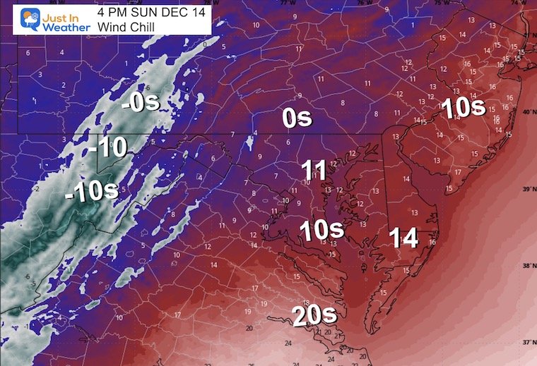
SUNDAY TEMPERATURES AND WIND
Temps will be cold and falling during the afternoon.
Morning Temperatures
Morning Wind Chill
Wind Forecast 7 AM to 7 PM
Afternoon Winds
Gusts to 30 mph.
Afternoon Temperatures
Afternoon Wind Chills
AFTER THE SNOW
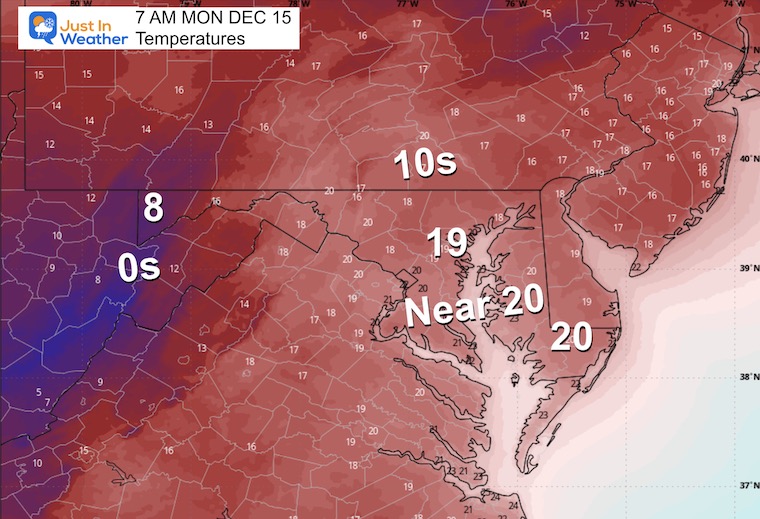
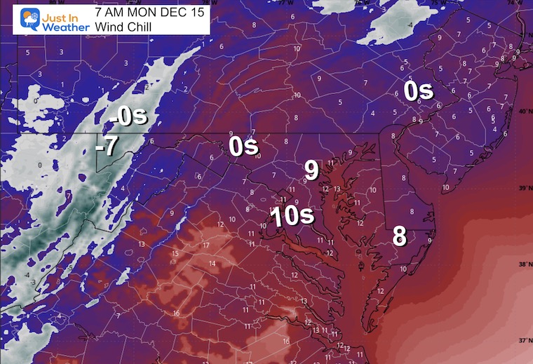
Monday Morning
Yes, it will be cold enough for the snow to stay around.
Morning Temperatures
Morning Wind Chills
Looking Later In The Week
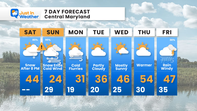
Jumping past the cold to the next weather system that will arrive with a brief warm-up. This will bring rain, wind, and maybe a thunderstorm on Friday.
7 Day Forecast
- Snow Event: Late Saturday Night Through Sunday Morning
- Sunday Afternoon: BRUTALLY COLD WIND
- Wednesday = 40s
- Thursday = 50s with rain arriving late
- Friday: Rain, wind, and maybe a T’Storm
Subscribe for eMail Alerts
Snow Report December 5 to 6 and Grade My Forecast
In case you missed it. The brief summary of the final snow totals from the last event.

My Winter Outlook For Above-Average Snow
Click here for the full report

La Niña Advisory
This was issued October 9, as expected: A weak and short-lived event to start winter may play a different role this winter.

In Case You Missed It
Woolly Bear Caterpillar Winter Folklore
These are NOT all the same caterpillar!

Winter Outlook From 2 Farmers’ Almanacs

STEM Assemblies/In School Fields Trips Are Back
Click to see more and ‘Book’ a visit to your school

THANK YOU:
Baltimore Sun Magazine Readers’ Choice Best Of Baltimore

Maryland Trek 12 Day 7 Completed Sat August 9
UPDATED: We raised OVER $170,000 for Just In Power Kids – AND Still Collecting More
The annual event: Hiking and biking 329 miles in 7 days between The Summit of Wisp to Ocean City.
Each day, we honor a kid and their family’s cancer journey.
Fundraising is for Just In Power Kids: Funding Free Holistic Programs. I never have and never will take a penny. It is all for our nonprofit to operate.
Click here or the image to donate:

RESTATING MY MESSAGE ABOUT DYSLEXIA
I am aware there are some spelling and grammar typos and occasional other glitches. I take responsibility for my mistakes and even the computer glitches I may miss. I have made a few public statements over the years, but if you are new here, you may have missed it: I have dyslexia and found out during my second year at Cornell University. It didn’t stop me from getting my meteorology degree and being the first to get the AMS CBM in the Baltimore/Washington region. One of my professors told me that I had made it that far without knowing and to not let it be a crutch going forward. That was Mark Wysocki, and he was absolutely correct! I do miss my mistakes in my own proofreading. The autocorrect spell check on my computer sometimes does an injustice to make it worse. I can also make mistakes in forecasting. No one is perfect at predicting the future. All of the maps and information are accurate. The ‘wordy’ stuff can get sticky. There has been no editor who can check my work while writing and to have it ready to send out in a newsworthy timeline. Barbara Werner is a member of the web team that helps me maintain this site. She has taken it upon herself to edit typos when she is available. That could be AFTER you read this. I accept this and perhaps proves what you read is really from me… It’s part of my charm. #FITF
Please share your thoughts and best weather pics/videos, or just keep in touch via social media.


