Friday, November 28 2025
Morning Report
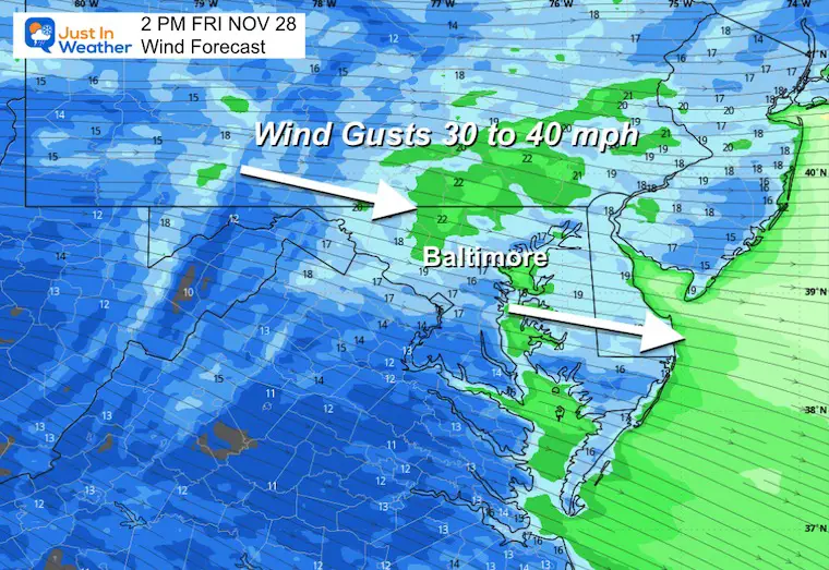
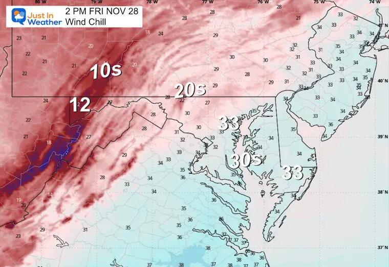
This Black Friday feels like winter as the core of the cold air passes through. Wind chills in the 20s will get a boost of strong gusts up to 40 mph this afternoon. There is one more impulse that may carry snow flurries into the northern parts of metro Baltimore.
Two storm systems are in view, and there has been a lot of information online about this. I still see the chance for snow NEAR the cities, but I am playing this very conservatively. Often, the first event can stir excitement and also lean on the lower or warmer side of model guidance. In this report is a breakdown and a brief comparison of what I am seeing right now.
Headlines
- Today: Chilly Winds; Flurries Possible Near and North/West of Baltimore
- Sunday: Chilly Afternoon Rain; Might BEGIN with a Wintry Mix INLAND
- Tuesday: Larger Storm With A Wintry Mix. The details are still NOT REFINED for how the snow, ice, and rain will plot across metro areas.
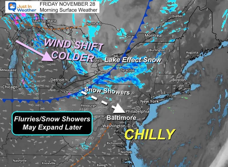
Morning Surface Weather
Chilly winds will grow stronger this afternoon as a cold front passes to reinforce the arctic air.
This may carry flurries or snow showers into metro Baltimore and the Northern Suburbs.
Morning Observations
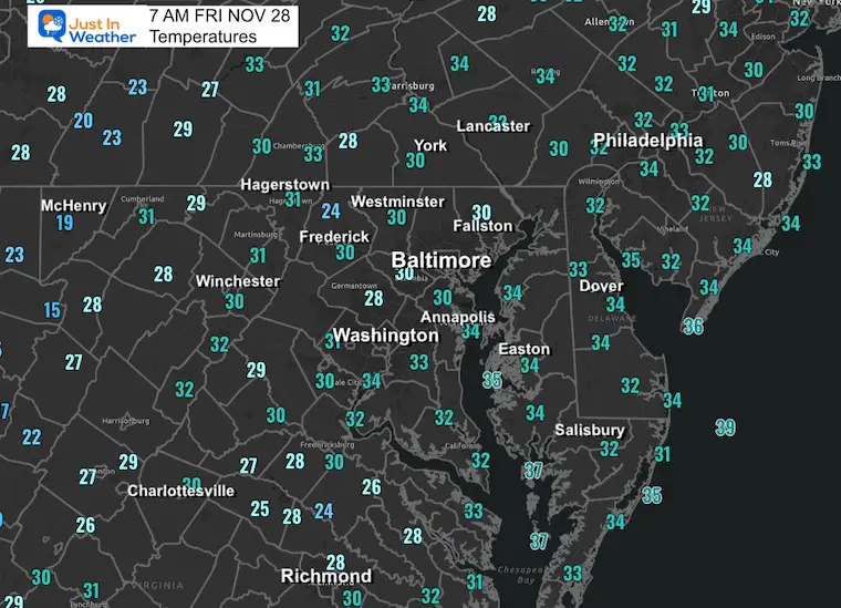
Temperatures
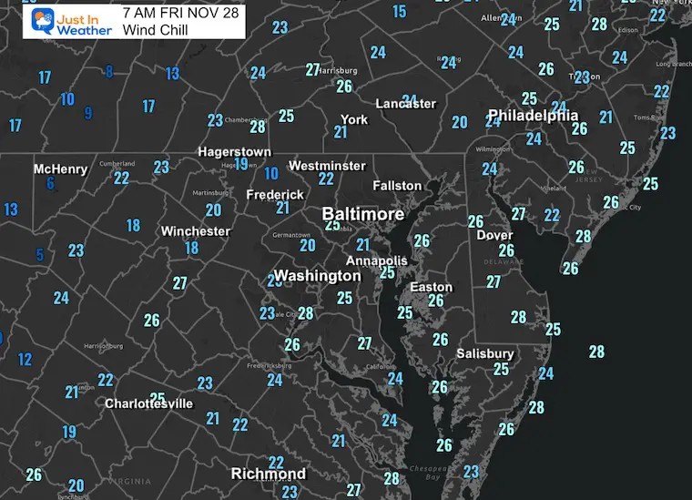
Wind Chills
TODAY
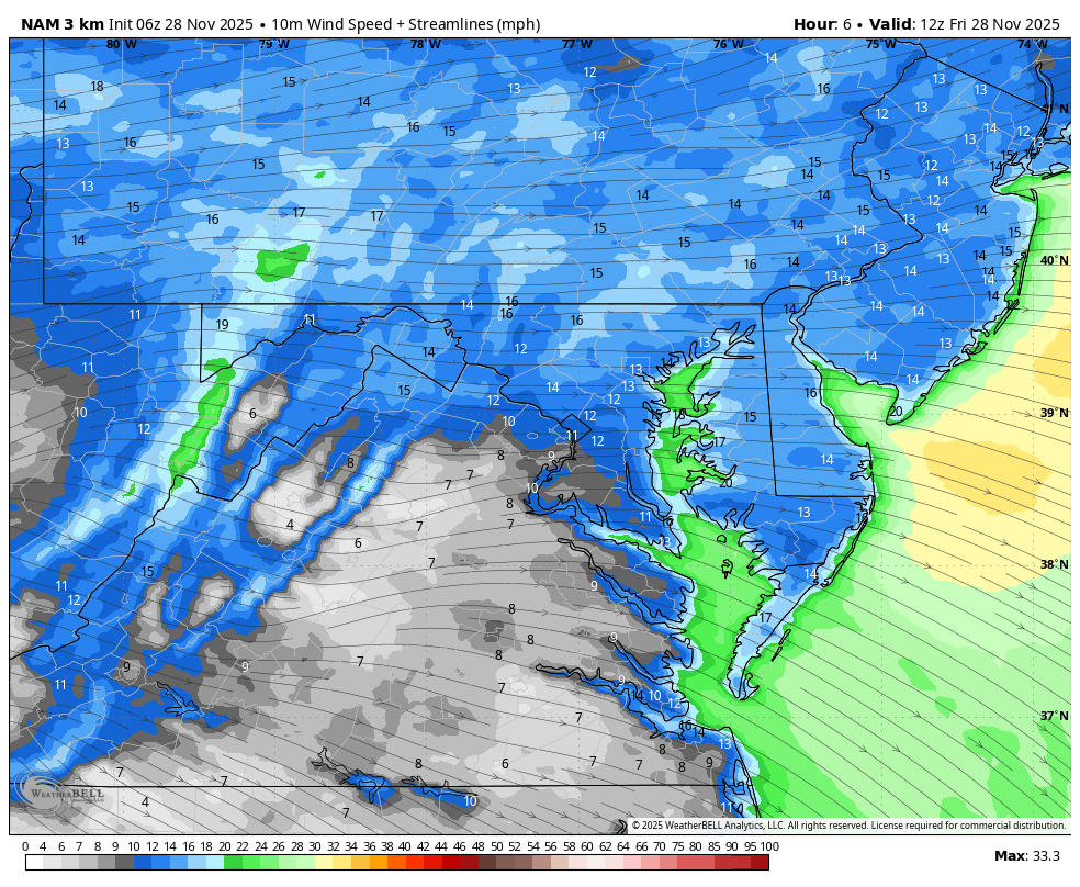
Wind Forecast through 7 PM
Afternoon Snapshot
Gusts 30 to 40 mph.
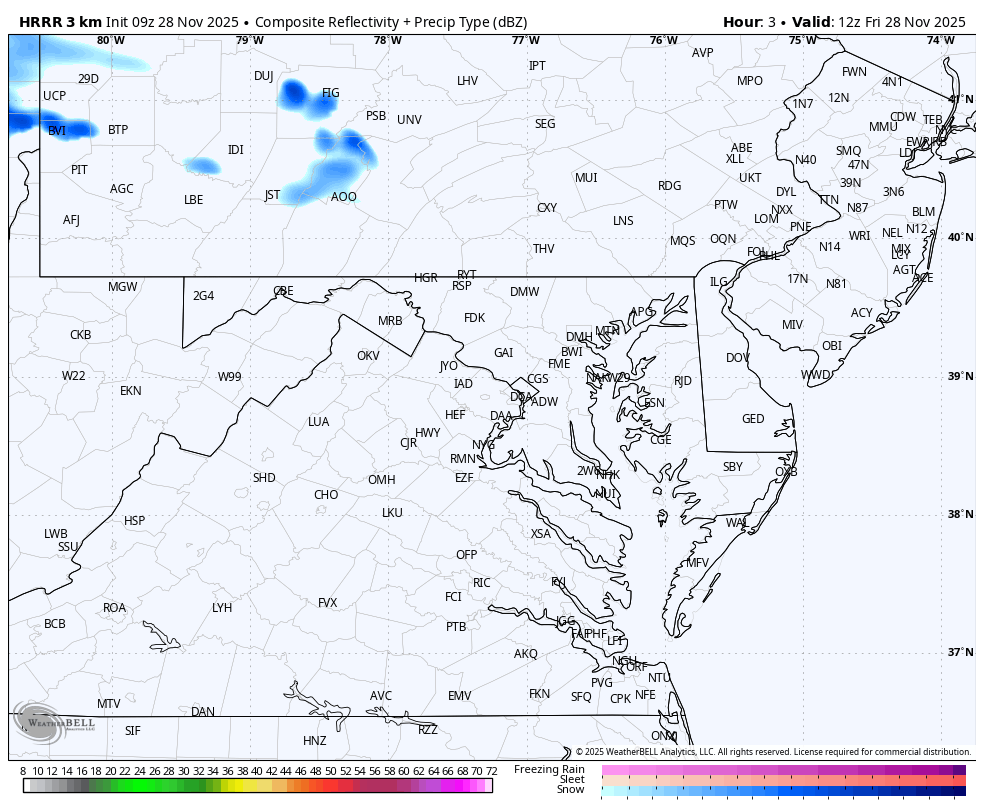
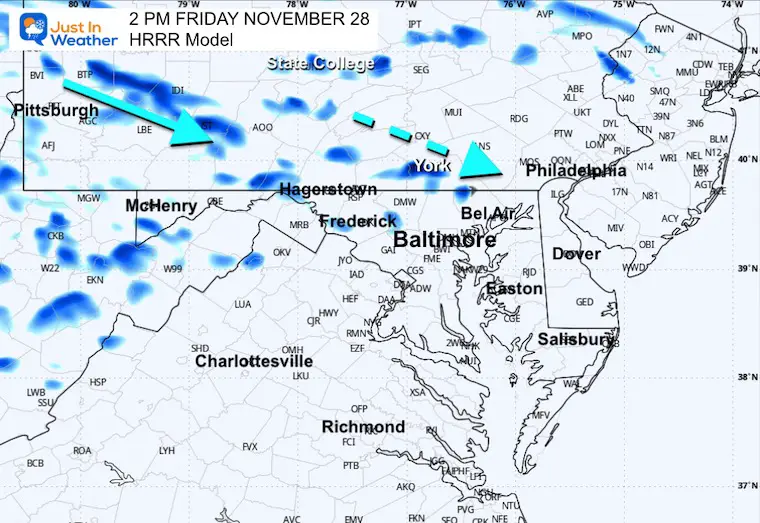
Radar Simulation Through 7 PM
Notice the streams of snow bands attempting to reach southern Pennsylvania and Northern Maryland.
Afternoon Snapshot
This product is not perfect! There may be more snow showers or flurries than shown here.
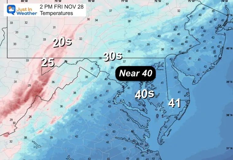
Afternoon Temperatures
Afternoon Wind Chills
Faith in the Flakes Store Open

CLIMATE DATA: Baltimore
Yesterday: Low 33F; High 46F
Precipitation: 0.00”
Top Wind Gust 39 mph
TODAY November 28
Sunrise at 7:04 AM
Sunset at 4:45 PM
Normal Low in Baltimore: 33ºF
Record 15ºF in 1951
Normal High in Baltimore: 53ºF
Record 73ºF 1990
Rainfall Deficit at BWI
- Ending 2024 = -8.00”
- Since Jan 1 = 6.50”
- We are STILL DOWN -14.50” INCLUDING LAST YEAR
Subscribe for eMail Alerts
My Winter Outlook For Above-Average Snow
Click here for the full report

SATURDAY
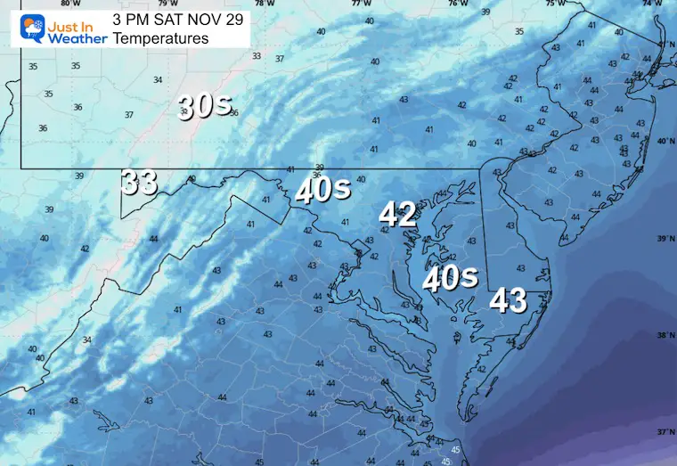
This will be a chilly day with more sunshine.
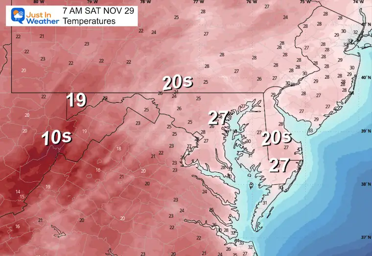
Morning Temperatures
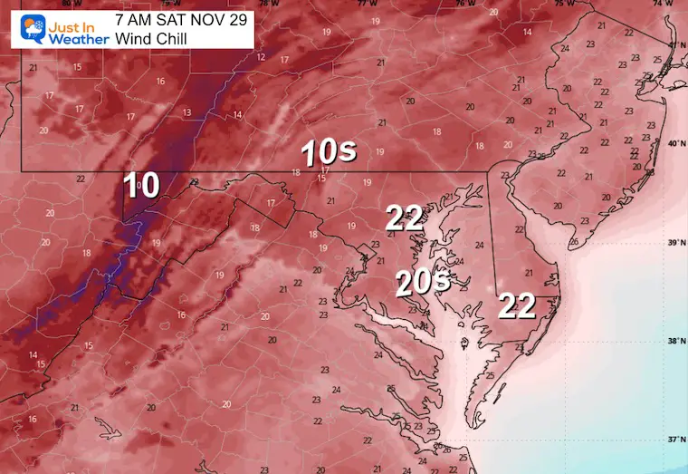
Wind Chills
Afternoon Temperatures
Saturday Afternoon Surface Weather
A clear day locally for the Eastern US as we watch the first of two storms develop in the Central US.
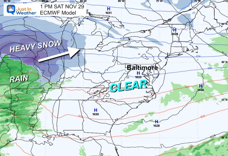
Two Storms To Track
In this active pattern on the edge of arctic air, two separate storm systems will track our way. The first will be Sunday, followed by a stronger event on Tuesday.
BOTH have cold enough air for a wintry mix, but the location of that snow, ice, and rain line near metro Baltimore and the I-95 corridor is still a wild card.
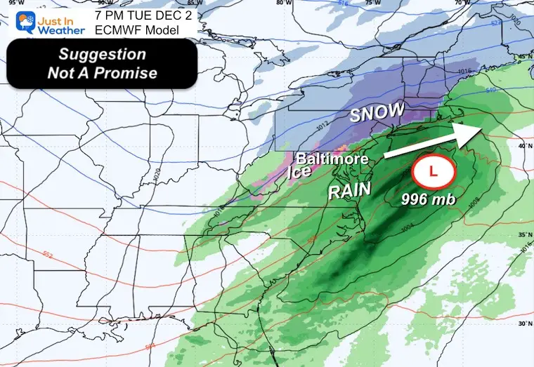
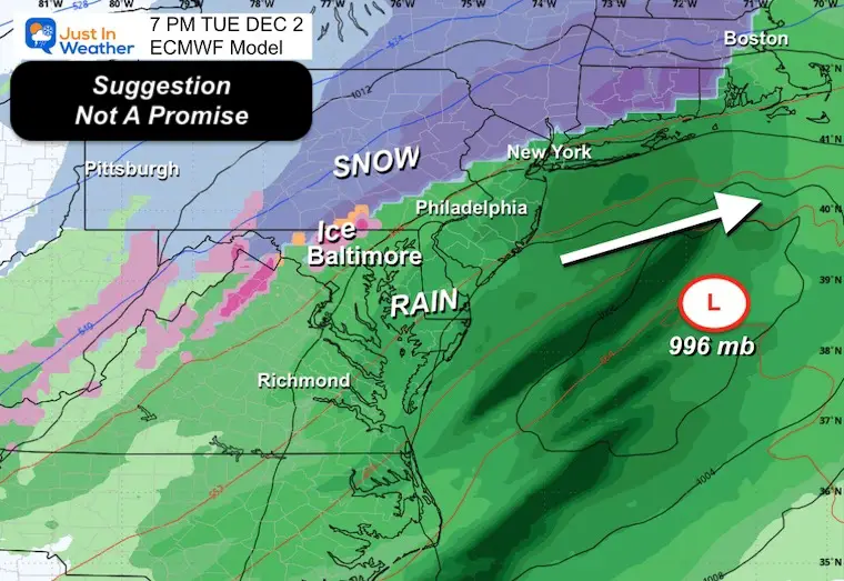
Here is a look at the European ECMWF Model. This is not the only answer, and below I have a comparison with two other models to show the spread of expectations.
Animation Saturday Afternoon to Wednesday Morning
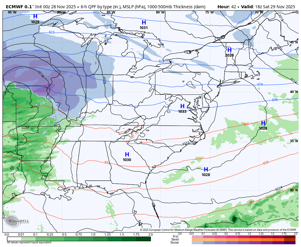
Snapshots
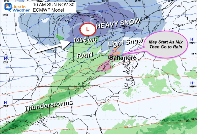
Sunday Morning
Depending on how early in the day this arrives, it may begin with a mix of snow and sleet INLAND, then turn to a chilly rain.
This should be primarily a rain event for metro areas and south during the afternoon. Light snow in Central Pennsylvania will eventually change to rain.
Heavy Snow will track across the Great Lakes, New York, and Northern New England.
Tuesday Afternoon
- This second storm may bring in a wintry mix NEAR Baltimore.
- A better chance inland to the West and North
- A chilly rain South and East to the Coast.
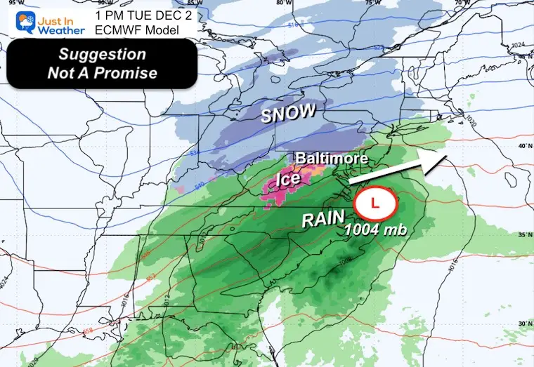
Tuesday Evening
As Low Pressure grows stronger and moves off the coast, colder air may pull south to enhance the snow areas and bring that wintry mix back into metro areas if they have changed to rain earlier.
Closer Look
The setup for where the snow and ice fall is the wild card. This is only one SUGGESTION and not a promise.
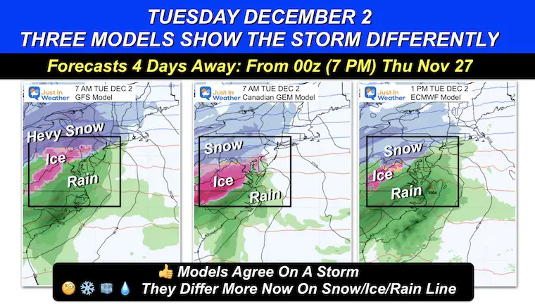
Model Comparison
Here is the spread between the GFS, Canadian GEM, and European Models.
These are the three I chose to show, but there are many others.
If you saw my social media post, this is a bit more divergent than before and shows the uncertainty of specifics.
Yes, there will be a storm. But how the snow, mix, and rain play out across metro Baltimore still needs to be fine-tuned.
Note
There will be a storm affecting travel on Sunday AND a larger one on Tuesday. That is part one of making a forecast. The specifics of how they behave locally will get fine-tuned when the storm actually forms. That is a limitation of weather forecasting, even with all the technology we have today.
Planning and patience are still my prime focus in this 4 to 5-day window.
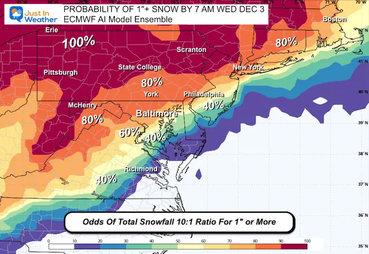
ODDS OF 1″ SNOW OR MORE BY WEDNESDAY MORNING
This is run from 51 different simulations to give the percentage of occurrence.
This may be a test for the AI Model, which is more aggressive for snow, and I am suspicious of that result.
ECMWF Operational Model Odds
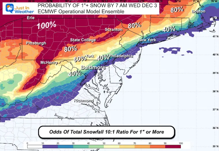
ECWMF AI Model Odds
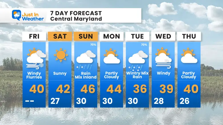
7 Day Forecast
- Today: Windy, Cold, And Flurries ‘Possible’
- Saturday: Sunny and Cold
- Sunday: Chilly Rain May Begin As Wintry Mix INLAND
- Tuesday/Wednesday also watching for the potential Wintry Mix or Chilly Rain.
La Niña Advisory
This was issued October 9, as expected: A weak and short-lived event to start winter may play a different role this winter.

In Case You Missed It
Woolly Bear Caterpillar Winter Folklore
These are NOT all the same caterpillar!

Winter Outlook From 2 Farmers’ Almanacs

STEM Assemblies/In School Fields Trips Are Back
Click to see more and ‘Book’ a visit to your school

THANK YOU:
Baltimore Sun Magazine Readers’ Choice Best Of Baltimore

Maryland Trek 12 Day 7 Completed Sat August 9
UPDATED: We raised OVER $166,000 for Just In Power Kids – AND Still Collecting More
The annual event: Hiking and biking 329 miles in 7 days between The Summit of Wisp to Ocean City.
Each day, we honor a kid and their family’s cancer journey.
Fundraising is for Just In Power Kids: Funding Free Holistic Programs. I never have and never will take a penny. It is all for our nonprofit to operate.
Click here or the image to donate:

RESTATING MY MESSAGE ABOUT DYSLEXIA
I am aware there are some spelling and grammar typos and occasional other glitches. I take responsibility for my mistakes and even the computer glitches I may miss. I have made a few public statements over the years, but if you are new here, you may have missed it: I have dyslexia and found out during my second year at Cornell University. It didn’t stop me from getting my meteorology degree and being the first to get the AMS CBM in the Baltimore/Washington region. One of my professors told me that I had made it that far without knowing and to not let it be a crutch going forward. That was Mark Wysocki, and he was absolutely correct! I do miss my mistakes in my own proofreading. The autocorrect spell check on my computer sometimes does an injustice to make it worse. I can also make mistakes in forecasting. No one is perfect at predicting the future. All of the maps and information are accurate. The ‘wordy’ stuff can get sticky. There has been no editor who can check my work while writing and to have it ready to send out in a newsworthy timeline. Barbara Werner is a member of the web team that helps me maintain this site. She has taken it upon herself to edit typos when she is available. That could be AFTER you read this. I accept this and perhaps proves what you read is really from me… It’s part of my charm. #FITF
Please share your thoughts and best weather pics/videos, or just keep in touch via social media.


