


Winter Weather Advisory Sunday As Snowfall In Two Parts Affecting Two Different Areas
Saturday Evening Update January 17 2026 One thing I carry after all of my years of forecasting: If one model does a really good job in an active pattern, then…
Thanksgiving Morning Thursday, November 27 2025
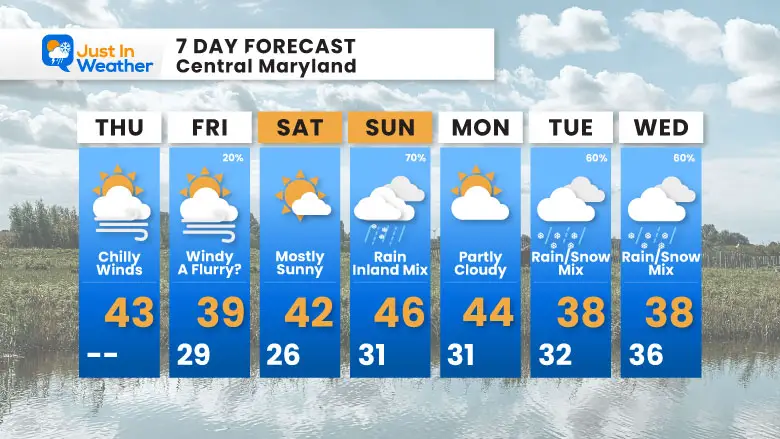
There is a lot of weather going on, and it can be overwhelming. I’ve posted lots of maps below to show it! I want to touch on a few things on this special Thanksgiving Holiday report that includes our local weather through the holiday, the main headline to our north, and two storms that suggest inland snow.
I know there is a chance for snow in the cities, but I am playing this very conservatively. Often, the first event can stir excitement and also lean on the lower side of model guidance.
This is from the European AI Model Ensemble. 51 different solutions are generated, and the odds of getting this result (1” snow) is what we see here.
Please see the forecast maps below…
This allows for errors in the operational model plot I showed above. There is wiggle room, and not all information is known this far out in time.
If you want snow, there are really good chances, AND it is early. Also note that the ground temperatures and influence from the warmer water of the Chesapeake Bay will play a role in metro areas for obstacles to what can fall, AND if it snows, what can stick.

The high winds are producing locally heavy snow. That is pretty common. The peak wind and high water rise were rare!
Yesterday: Low 46F; High 69F
Precipitation: 0.01” The storm was north of the airport
Top Wind Gust 43 mph
Sunrise at 7:03 AM
Sunset at 4:45 PM
Normal Low in Baltimore: 34ºF
Record 18ºF in 1903; 1974; 1991
Normal High in Baltimore: 53ºF
Record 74ºF 1896
Rainfall Deficit at BWI
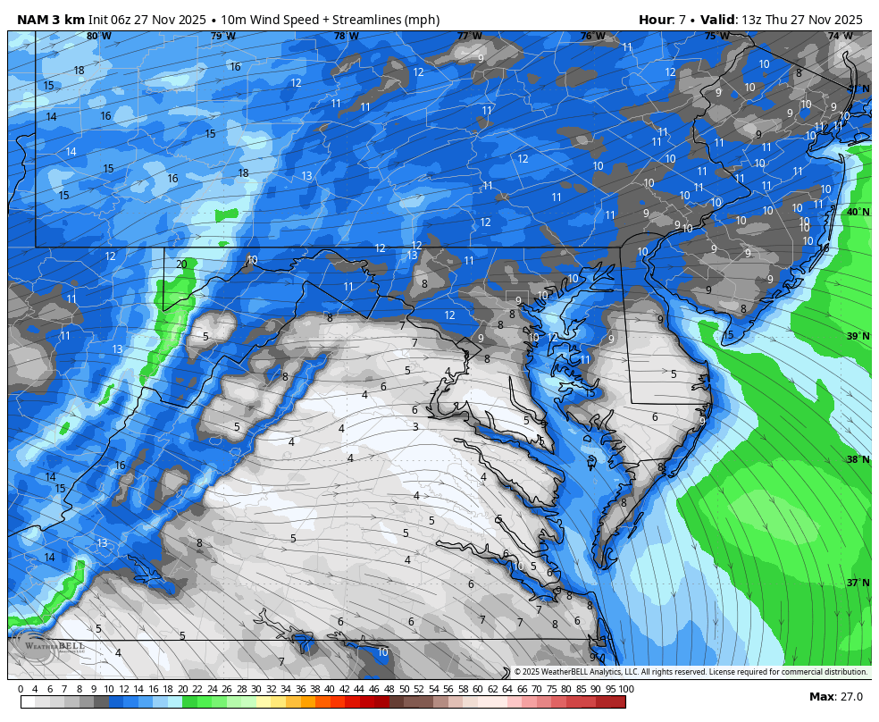
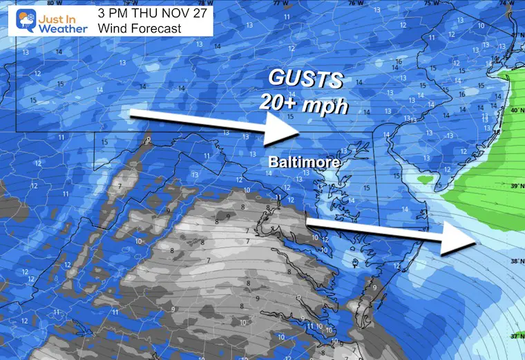
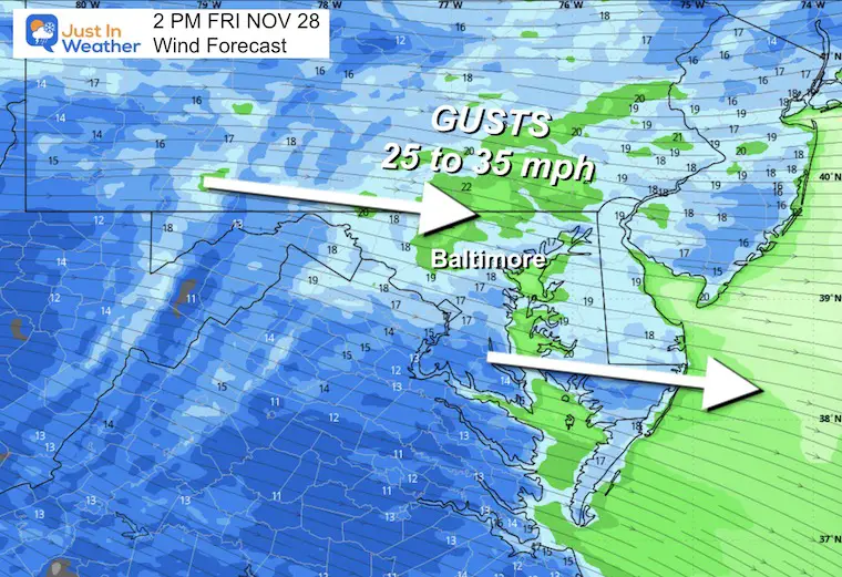
Steady winds 10 to 20 mph with gusts to 30 mph.

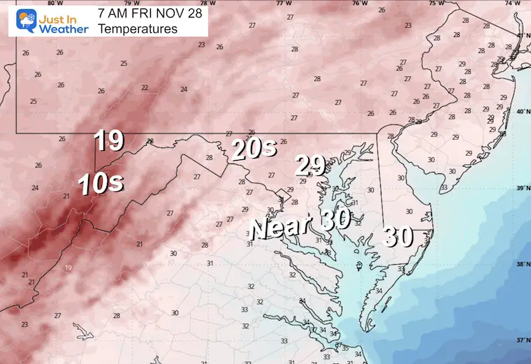
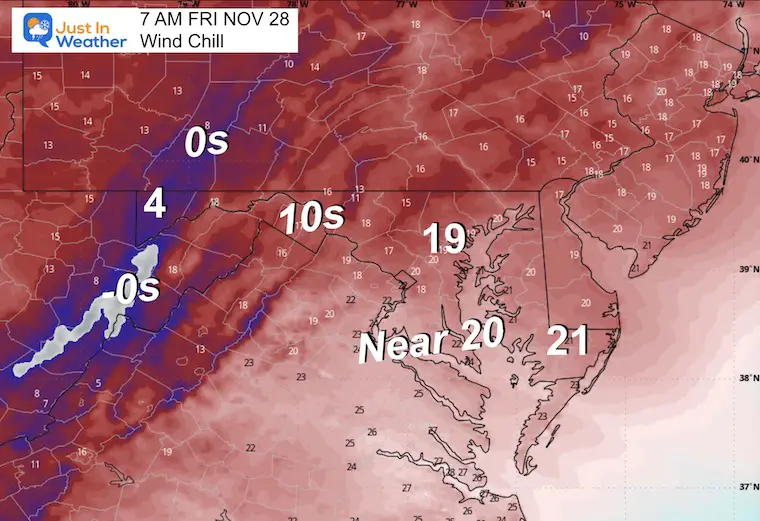
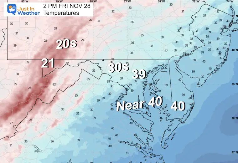
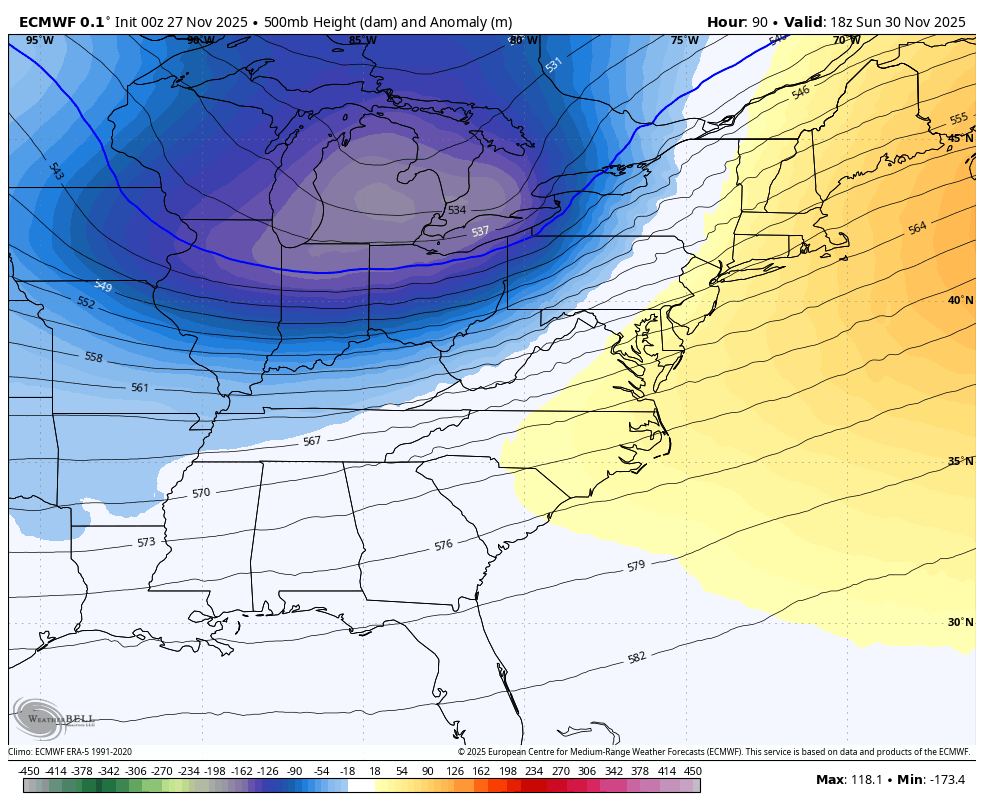
This will be the core of this cold air. The upper-level pattern holds the potential for some ambient snow flurries.
I am working with Jarrettsville Furniture on this great promotion to possibly get free furniture if we get snow on Christmas.
Here’s my first announcement. More info to come.
Subscribe for eMail Alerts
Sign up and be the first to know!

This plot of spin and energy aloft suggests support for carrying some flurries or even snow showers. This will NOT accumulate locally, but may bring some ambiance flakes.
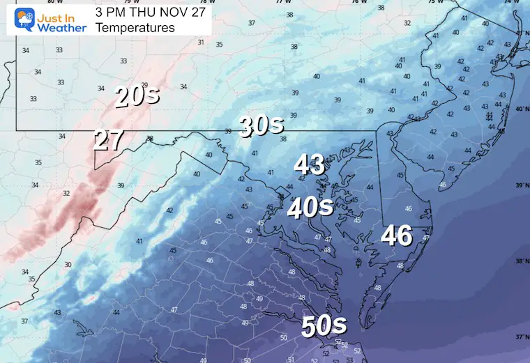
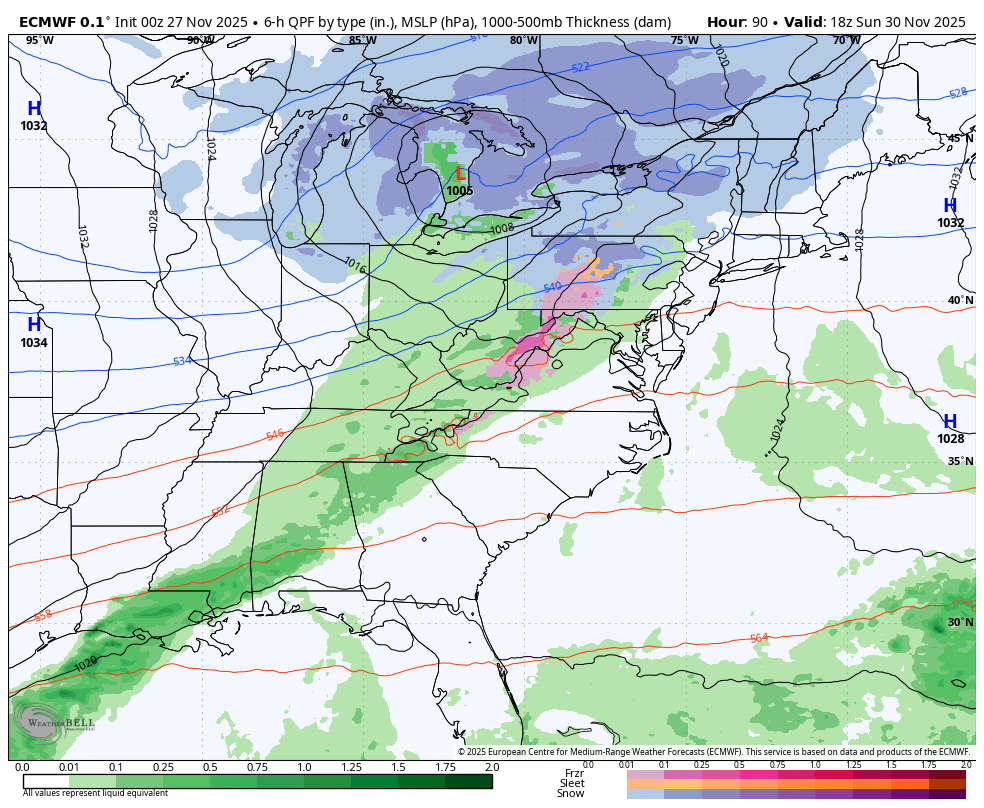
The first of two storms on the edge of the core cold in the jet stream is likely to track inland. This brings a chilly rain into most areas in the afternoon.
Snow or a wintry mix inland COULD creep to our closer suburbs IF this arrives earlier to catch on to the colder morning air.
Even if the happens, the trend will be to rain later in the day.

Two waves of Low Pressure and for most metro areas this will mean a chilly rain. The inland regions, West and North, may see the first wintry mix of the season with each event.
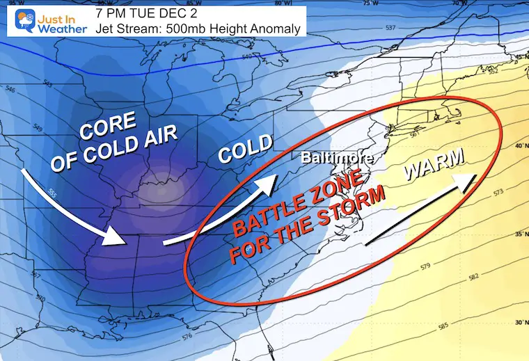
The second system will track farther south and east. Will the cold air catch up in time?
That is the age-old debate. As I see it now, the odds and climatology for this time of year support a warming effect from the Bay to keep metro areas and south with more rain likely.
Inland areas may start and end with slushy snow.
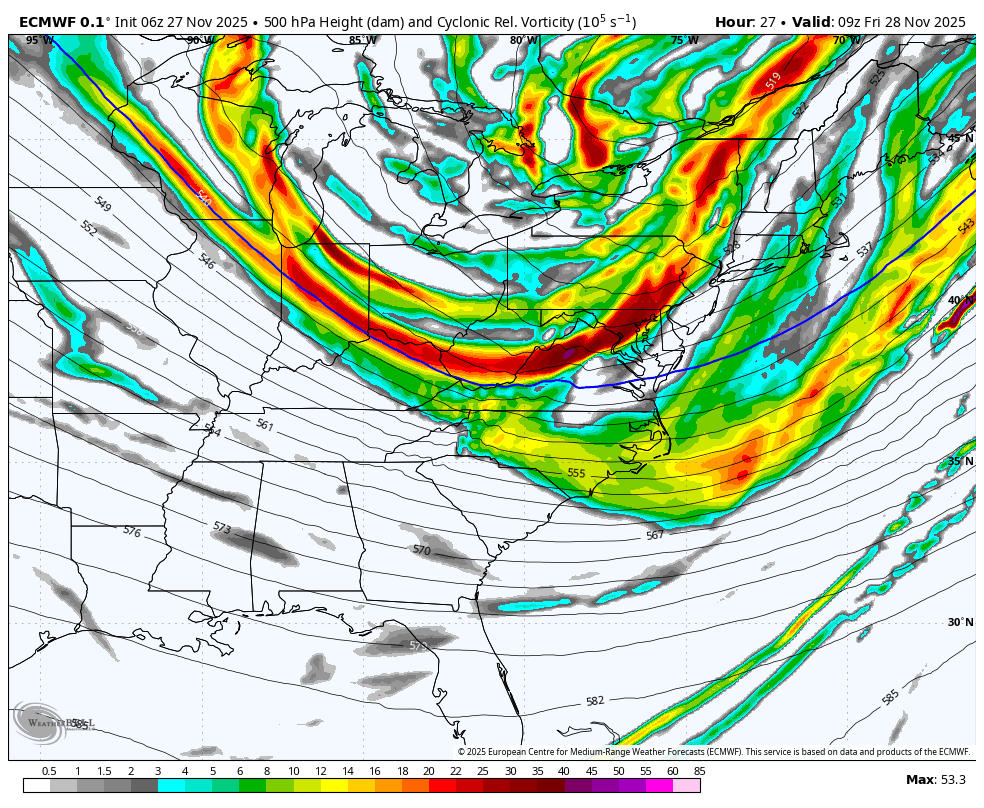
The next wave of cold air will be building in from the Central US/Canada and help feed into the storm track.
The battle zone is often in the region BETWEEN the Arctic air and the warm flow ahead of it. This is why there is usually a snow and rain zone with winter storms.


This is from the European AI Model Ensemble. 51 different solutions are generated, and the odds of getting this result (1” snow) is what we see here.
This allows for errors in the operational model plot I showed above. There is wiggle room, and not all information is known this far out in time.
If you want snow, there are really good chances, AND it is early. Also note that the ground temperatures and influence from the warmer water of the Chesapeake Bay will play a role in metro areas for obstacles to what can fall, AND if it snows, what can stick.
Subscribe for eMail Alerts
Sign up and be the first to know!

Click here for the full report

This was issued October 9, as expected: A weak and short-lived event to start winter may play a different role this winter

These are NOT all the same caterpillar!


Click to see more and ‘Book’ a visit to your school


The annual event: Hiking and biking 329 miles in 7 days between The Summit of Wisp to Ocean City.
Each day, we honor a kid and their family’s cancer journey.
Fundraising is for Just In Power Kids: Funding Free Holistic Programs. I never have and never will take a penny. It is all for our nonprofit to operate.
Click here or the image to donate:

I am aware there are some spelling and grammar typos and occasional other glitches. I take responsibility for my mistakes and even the computer glitches I may miss. I have made a few public statements over the years, but if you are new here, you may have missed it: I have dyslexia and found out during my second year at Cornell University. It didn’t stop me from getting my meteorology degree and being the first to get the AMS CBM in the Baltimore/Washington region. One of my professors told me that I had made it that far without knowing and to not let it be a crutch going forward. That was Mark Wysocki, and he was absolutely correct! I do miss my mistakes in my own proofreading. The autocorrect spell check on my computer sometimes does an injustice to make it worse. I can also make mistakes in forecasting. No one is perfect at predicting the future. All of the maps and information are accurate. The ‘wordy’ stuff can get sticky. There has been no editor who can check my work while writing and to have it ready to send out in a newsworthy timeline. Barbara Werner is a member of the web team that helps me maintain this site. She has taken it upon herself to edit typos when she is available. That could be AFTER you read this. I accept this and perhaps proves what you read is really from me… It’s part of my charm. #FITF