


Winter Weather Advisory Sunday As Snowfall In Two Parts Affecting Two Different Areas
Saturday Evening Update January 17 2026 One thing I carry after all of my years of forecasting: If one model does a really good job in an active pattern, then…
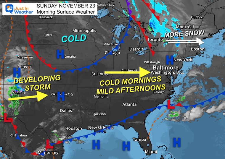
Sunday, November 23, 2025
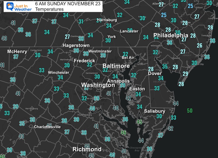
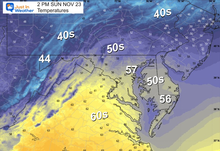
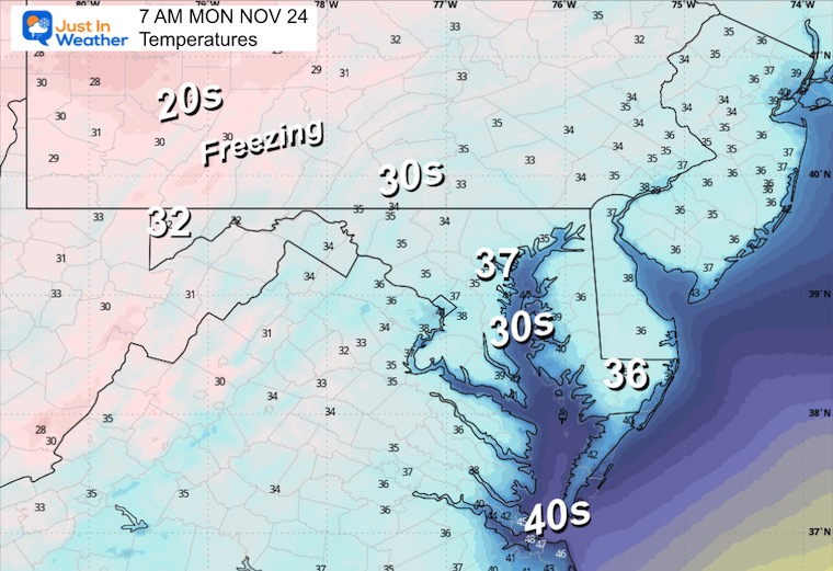
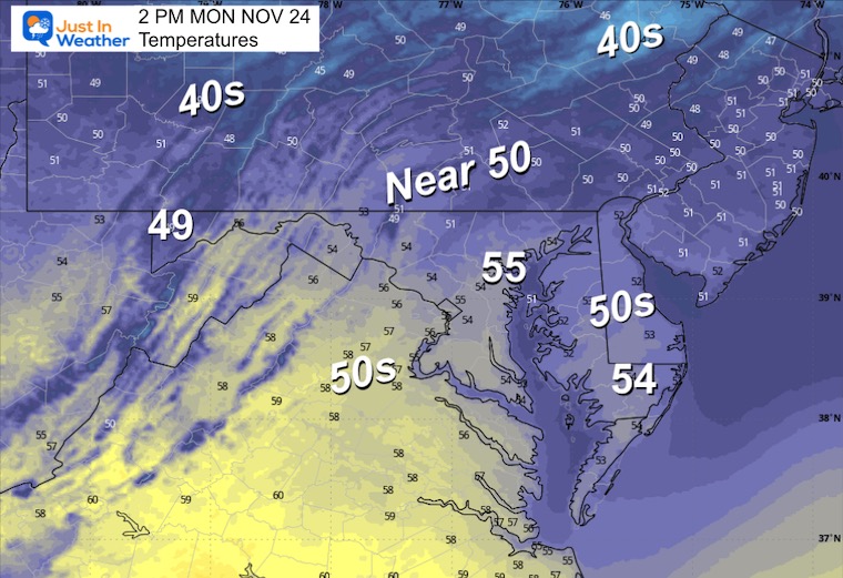
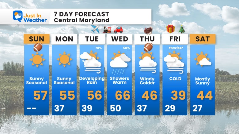
A cold morning with some areas of fog, but we will get the sun to dominate, allowing temps to return to seasonal levels in the mid-50s. This is good news for the Ravens’ home game; however, the next game on Thanksgiving night will be cold!
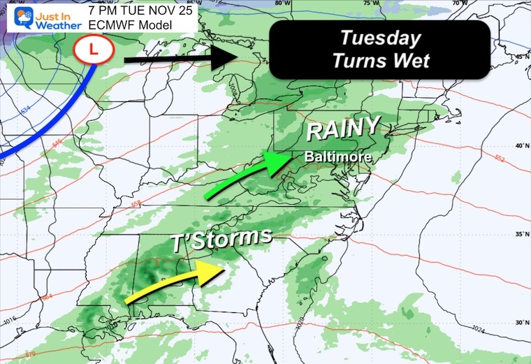
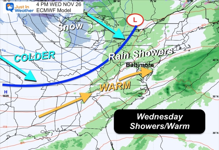
During the work week, we can expect the next rain to develop on Tuesday. It will become steady and maybe heavy at night.
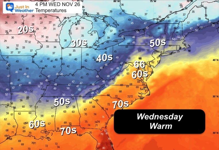
On Wednesday, the showers will be scattered as temperatures surge into the 60s.
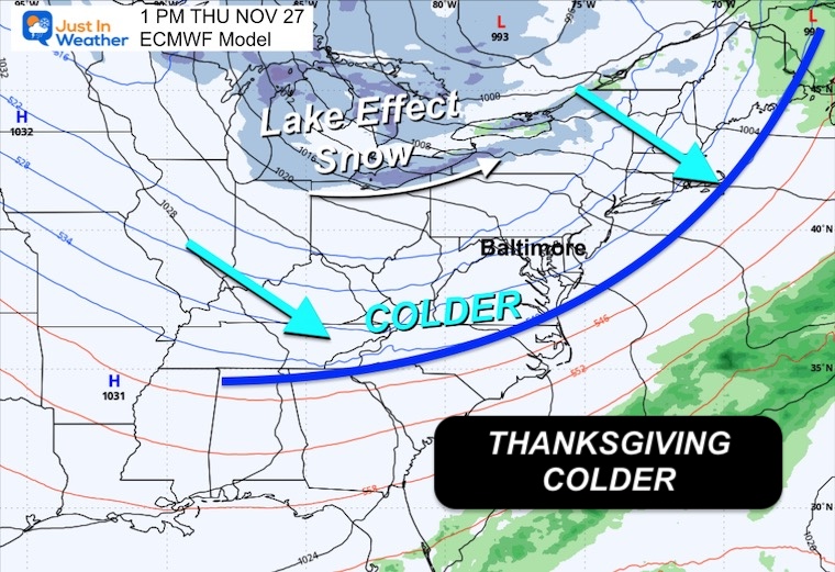
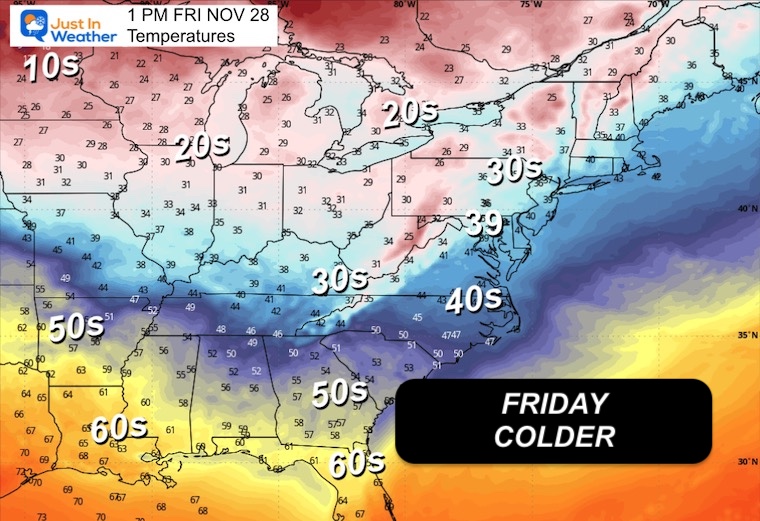
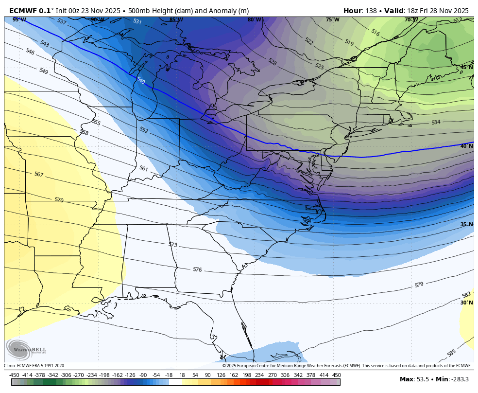
When the cold front swings through, Thanksgiving will be COLDER! In fact, the holiday will have falling temps during the afternoon and a very chilly shopping Friday with the core of the arctic air that may keep many in the region in the 30s.
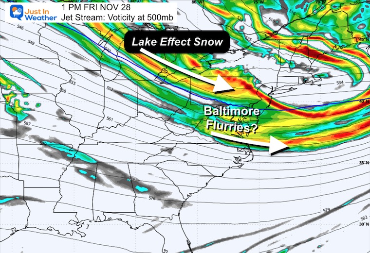
I am not seeing support that maybe some flurries could fly on Friday with the cold core.
This will not last long as a warm-up will bounce back 60s for early December. There is more arctic air that is likely for much of December.
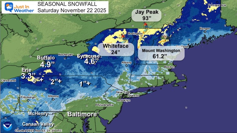
While there has been a lot of chatter about our early start to winter, there has been an abundance of snow in New England, with some records that may get broken.
Jay Peak, VT has 93 INCHES
Mount Washington = 61.2″
Whiteface, NY has 24″
NWS Locations
Some areas may begin with fog, but overall sunshine will allow the chilly start to warm up back to the 50s.
We can expect the same tomorrow before the developing storm system spreads our way.
Yesterday: Low 36F; High 57F
Precipitation: 0.22”
Sunrise at 6:59 AM
Sunset at 4:47 PM
Normal Low in Baltimore: 35ºF
Record 16ºF in 1880
Normal High in Baltimore: 55ºF
Record 74ºF 1979
Rainfall Deficit at BWI
Click here for the full report

I am working with Jarrettsville Furniture on this great promotion to possibly get free furniture if we get snow on Christmas.
Here’s my first announcement. More info to come.
Subscribe for eMail Alerts
Sign up and be the first to know!
The next system will arrive sooner, with rain on Tuesday and lingering showers on Wednesday. This will include a warm-up followed by colder air during the holiday. The core of the cold will be on the big shopping day Friday.
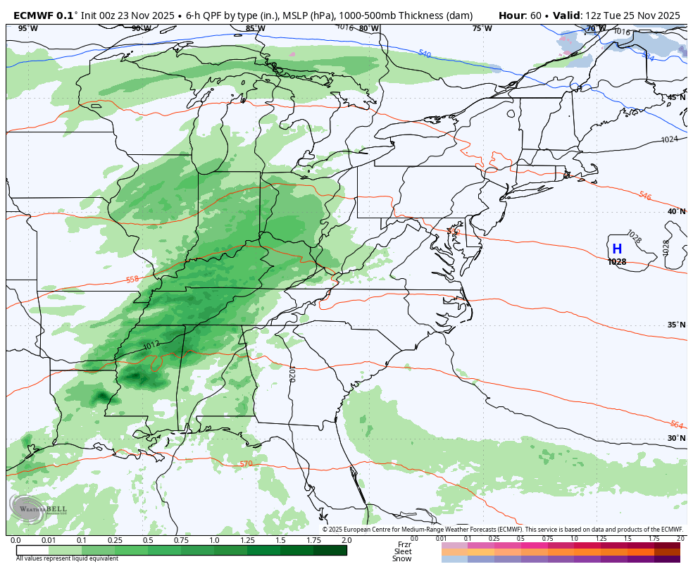
Developing rain that will be steady in the afternoon and evening.
Strong thunderstorms to the south.
Another quick-moving rain event is likely to time out early in the day, followed by a warm-up.
A dry day with gusty winds as the colder air fills in. The warmest part of the day may be before sunrise.
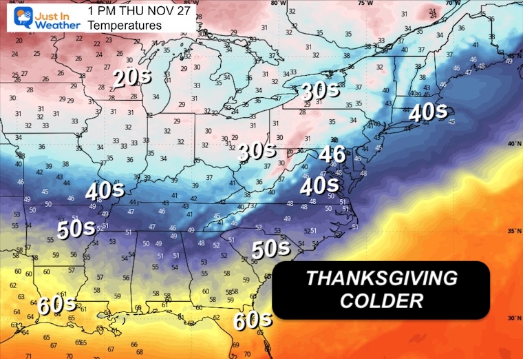
This may be a day with many areas staying in the 30s to near 40°F during the afternoon.
This is the indication that some Lake Effect Snow Showers may carry flurries into Central Maryland.
The arctic blast will relax over the next weekend. A big return warm-up will follow to start December. This also may be short-lived.
Subscribe for eMail Alerts
Sign up and be the first to know!
This was issued October 9, as expected: A weak and short-lived event to start winter may play a different role this winter

These are NOT all the same caterpillar!


Click to see more and ‘Book’ a visit to your school


The annual event: Hiking and biking 329 miles in 7 days between The Summit of Wisp to Ocean City.
Each day, we honor a kid and their family’s cancer journey.
Fundraising is for Just In Power Kids: Funding Free Holistic Programs. I never have and never will take a penny. It is all for our nonprofit to operate.
Click here or the image to donate:

I am aware there are some spelling and grammar typos and occasional other glitches. I take responsibility for my mistakes and even the computer glitches I may miss. I have made a few public statements over the years, but if you are new here, you may have missed it: I have dyslexia and found out during my second year at Cornell University. It didn’t stop me from getting my meteorology degree and being the first to get the AMS CBM in the Baltimore/Washington region. One of my professors told me that I had made it that far without knowing and to not let it be a crutch going forward. That was Mark Wysocki, and he was absolutely correct! I do miss my mistakes in my own proofreading. The autocorrect spell check on my computer sometimes does an injustice to make it worse. I can also make mistakes in forecasting. No one is perfect at predicting the future. All of the maps and information are accurate. The ‘wordy’ stuff can get sticky. There has been no editor who can check my work while writing and to have it ready to send out in a newsworthy timeline. Barbara Werner is a member of the web team that helps me maintain this site. She has taken it upon herself to edit typos when she is available. That could be AFTER you read this. I accept this and perhaps proves what you read is really from me… It’s part of my charm. #FITF