


Winter Weather Advisory Sunday As Snowfall In Two Parts Affecting Two Different Areas
Saturday Evening Update January 17 2026 One thing I carry after all of my years of forecasting: If one model does a really good job in an active pattern, then…
Wednesday, November 12, 2025
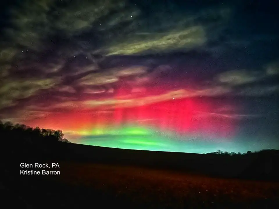
The big story is the extreme geomagnetic storm we had last night. We did get clouds and flurries overnight, which normally would be met with excitement. In this case, it blocked the second part of the sky show.
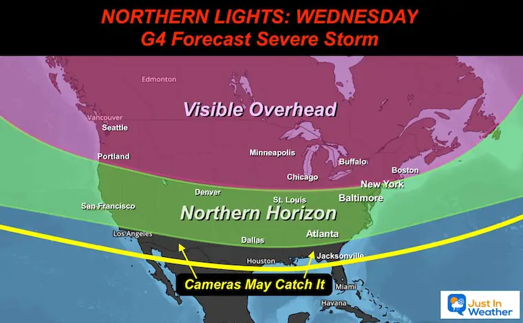
The Northern Lights reached all the way south into Florida. Here in the Mid-Atlantic, the display rivaled the May 2023 event. My photo display online was matched and even surpassed by so many other contributors. I want to start with this amazing image from Glen Rock, PA, thanks to Kristine Barron.
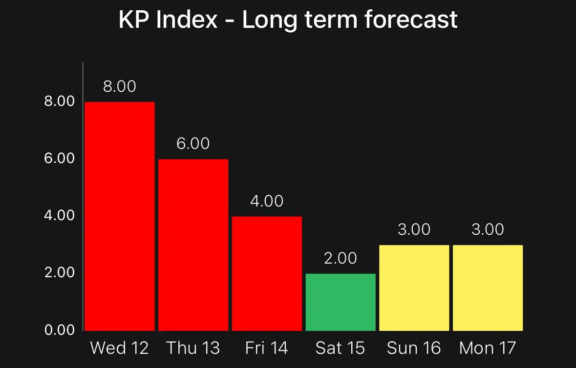
Globally, the Kp Index reached 9, which is very rare and was stronger than forecast. Here is the Hp Index from Germany. It is seen as similar to the Kp index but with a more frequent update every 30 minutes.

The NOAA Forecast still has us under a ‘Watch’ for more today. The G4 Storm may produce another Kp 8, but the timing is key. This new surge may benefit Europe during our afternoon hours, but there is a chance we get more of the Aurora show tonight.
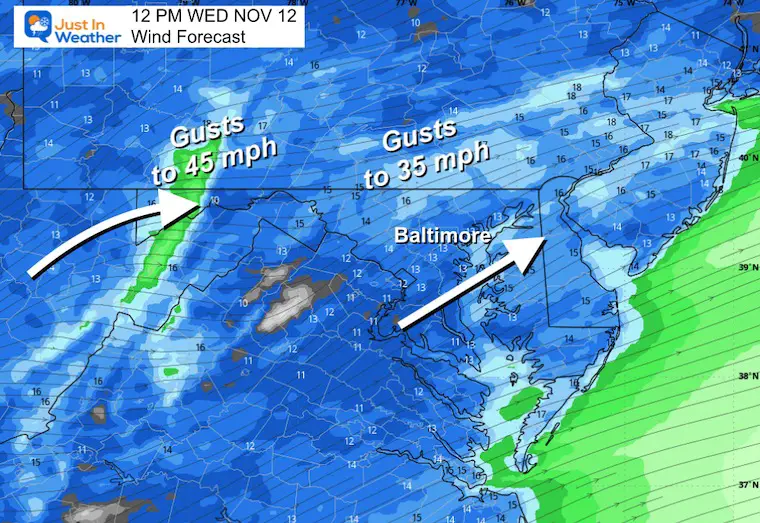
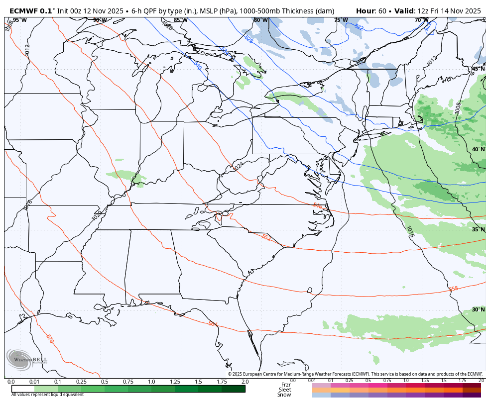
This active pattern is producing a Lake Effect surge in New York.
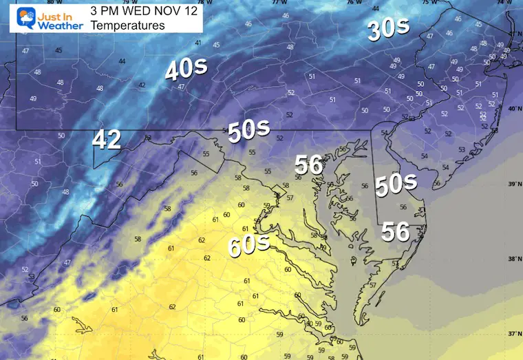
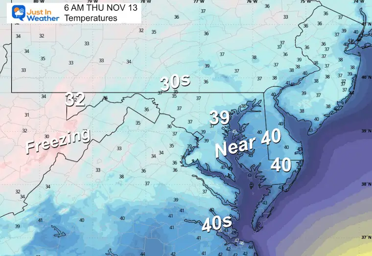
Another frontal boundary across the Ohio Valley will keep the winds very gusty, then reinforce the colder air from the Northern Plains.
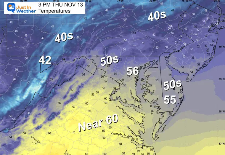
Temps relax ‘closer’ to normal in the South East US.
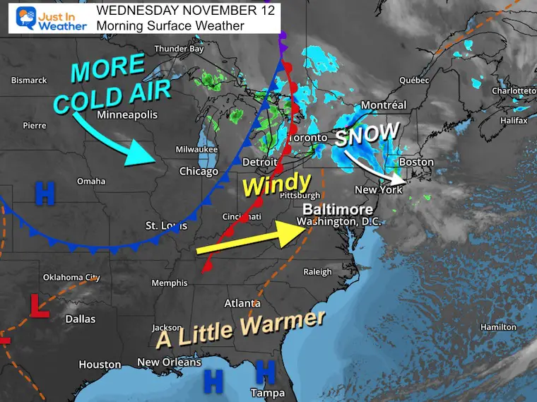

We should have a mostly clear sky, but we can’t rule out passing clouds.
Overnight and into the morning hours, it will be more overcast farther south.

Yesterday: Low 30F; High 45F
Precipitation: 0.00”
Sunrise at 6:47 AM
Sunset at 4:54 PM
Normal Low in Baltimore: 37ºF
Record 18ºF in 1957
Normal High in Baltimore: 59ºF
Record 78ºF 1879
Rainfall Deficit at BWI
Click here for the full report

Subscribe for eMail Alerts
Sign up and be the first to know!
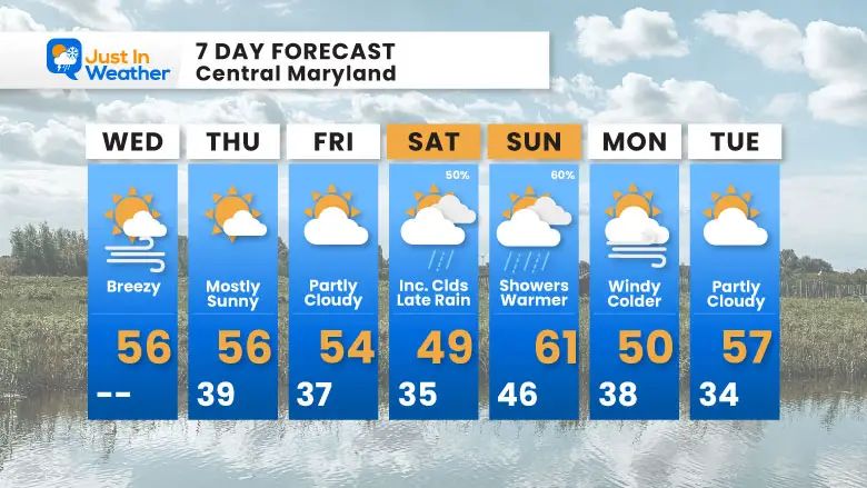
The active Northern Storm Track will send us more clouds and cooler air on Saturday as rain arrives later.
This is part of a warm front that will briefly bring up temps Sunday with scattered showers…Then more cold air.
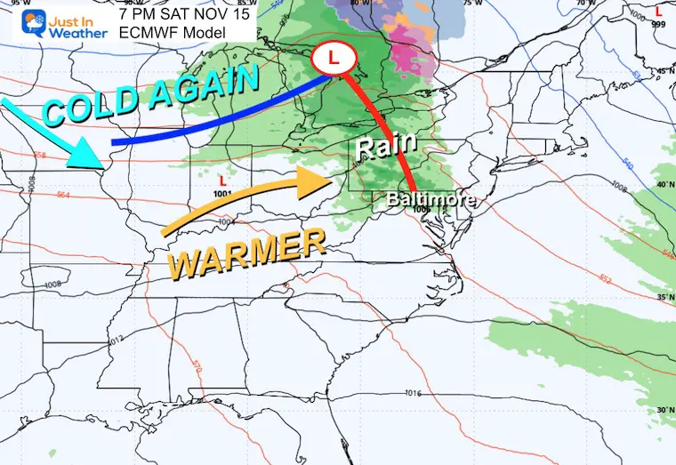
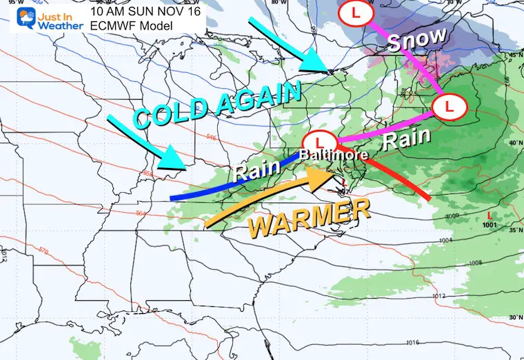
This pattern is very active, and the northern storm track will reinforce the cooler air as we remain on the edge of the influence.
I do expect we will get back to warmer air next week.
Subscribe for eMail Alerts
Sign up and be the first to know!

This was issued October 9, as expected: A weak and short-lived event to start winter may play a different role this winter

These are NOT all the same caterpillar!


Click to see more and ‘Book’ a visit to your school


The annual event: Hiking and biking 329 miles in 7 days between The Summit of Wisp to Ocean City.
Each day, we honor a kid and their family’s cancer journey.
Fundraising is for Just In Power Kids: Funding Free Holistic Programs. I never have and never will take a penny. It is all for our nonprofit to operate.
Click here or the image to donate:

I am aware there are some spelling and grammar typos and occasional other glitches. I take responsibility for my mistakes and even the computer glitches I may miss. I have made a few public statements over the years, but if you are new here, you may have missed it: I have dyslexia and found out during my second year at Cornell University. It didn’t stop me from getting my meteorology degree and being the first to get the AMS CBM in the Baltimore/Washington region. One of my professors told me that I had made it that far without knowing and to not let it be a crutch going forward. That was Mark Wysocki, and he was absolutely correct! I do miss my mistakes in my own proofreading. The autocorrect spell check on my computer sometimes does an injustice to make it worse. I can also make mistakes in forecasting. No one is perfect at predicting the future. All of the maps and information are accurate. The ‘wordy’ stuff can get sticky. There has been no editor who can check my work while writing and to have it ready to send out in a newsworthy timeline. Barbara Werner is a member of the web team that helps me maintain this site. She has taken it upon herself to edit typos when she is available. That could be AFTER you read this. I accept this and perhaps proves what you read is really from me… It’s part of my charm. #FITF