Monday, November 10 2025
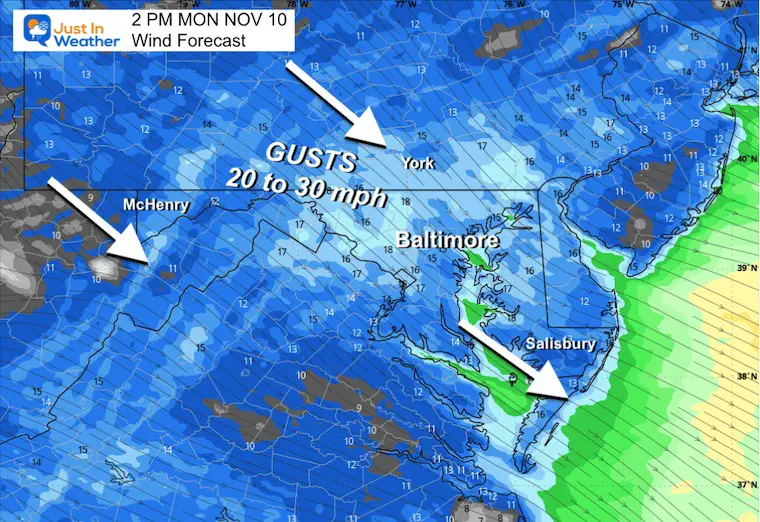
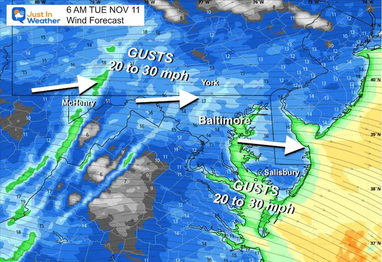
The rain and thunderstorms last night included pockets of hail and downpours. Now that the storm is moving away, the colder winds are beginning to move in. Gusts of 20 to 30 mph will keep temps cold and bring snow into the high mountains to our west.
There will be some accumulating snow in the mountains, but the setup is not ideal. More snow will fall in West Virginia, but Garrett County MD, may still get a couple of inches. I’ll be there to show you later.
The pre-season winter blast will bring snow to the mountains overnight and through Tuesday Morning. Flurries may pass into metro areas before sunrise on Tuesday.
While the pattern relaxes during the week, there will continue to be an active pattern with more cold impulses to our north.
I want to show the wide view first, then our local forecast:
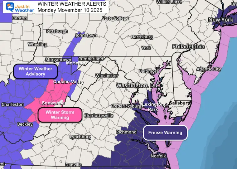
Weather Alerts
- Winter Weather Advisory includes Garrett County, MD
- Winter Storm Warning between Canaan Valley and Snowshoe, WV
- Freeze Warning: Calvert and St. Mary’s Counties in MD
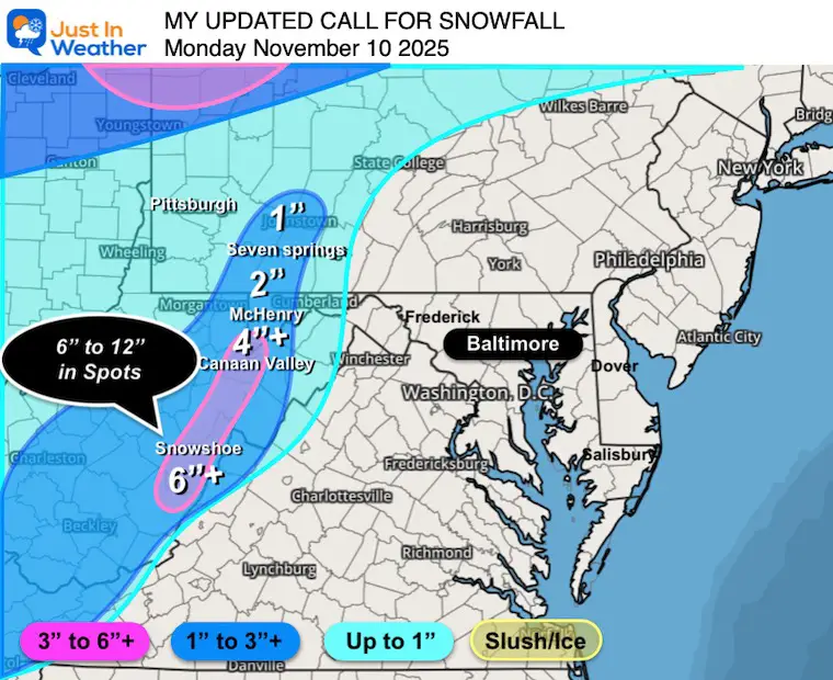
My Call For Snowfall
- I am lowering my expectations for Garrett County to 1” to 3”, with more in the southern part of the county.
- Heavier snow will fall between Canaan Valley and Snowshoe, WV
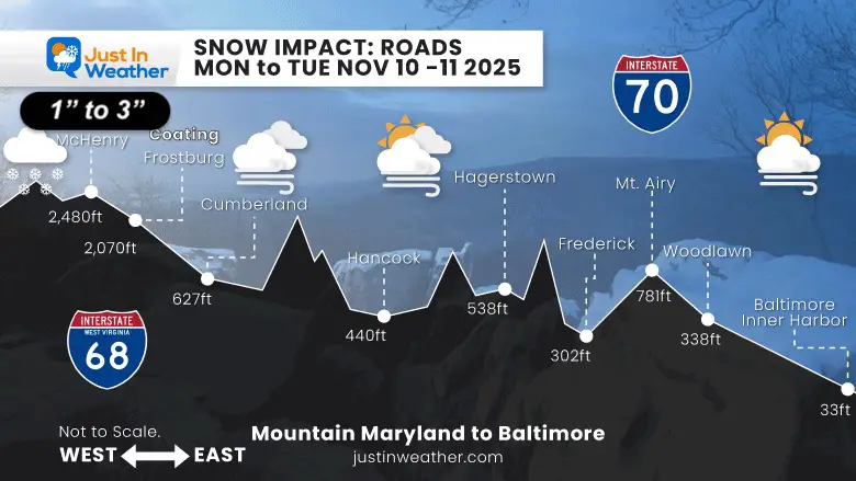
Driving Forecast: Maryland Highways
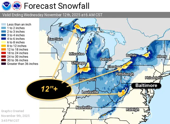
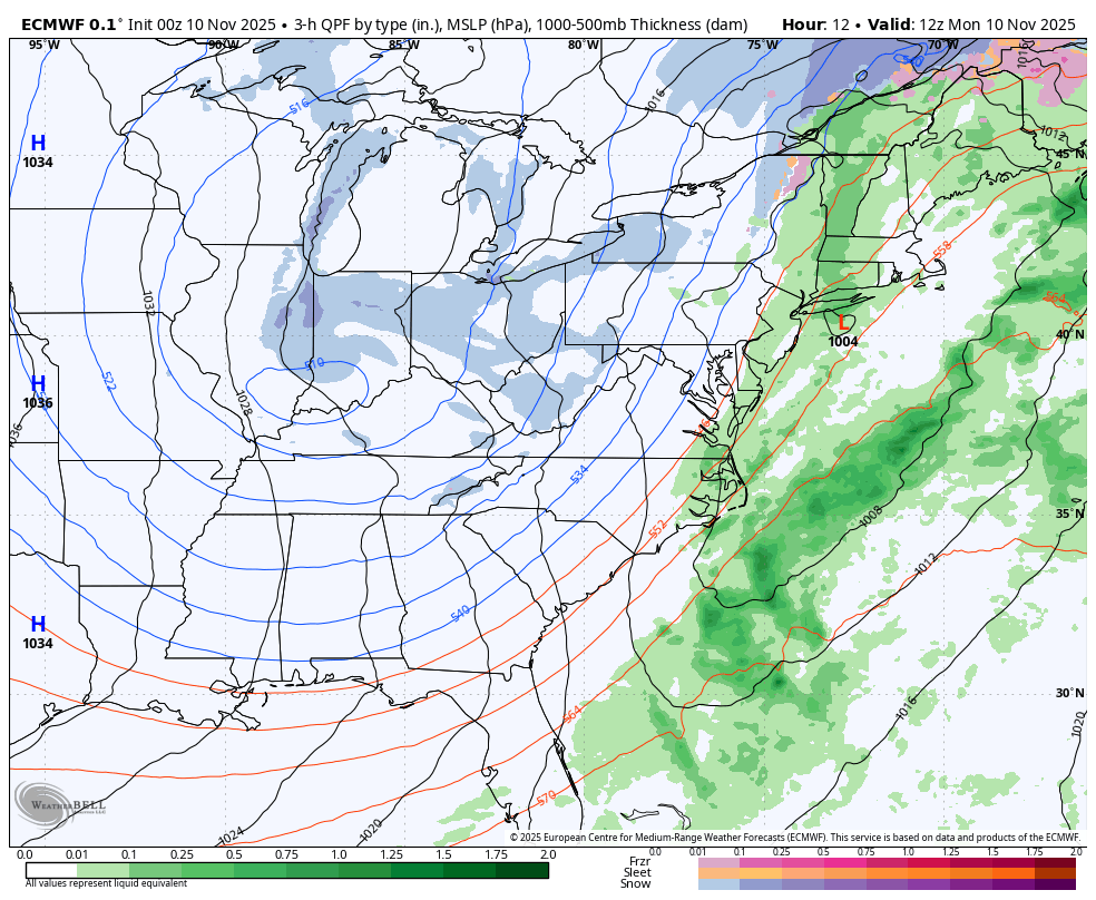
Broader View Snow
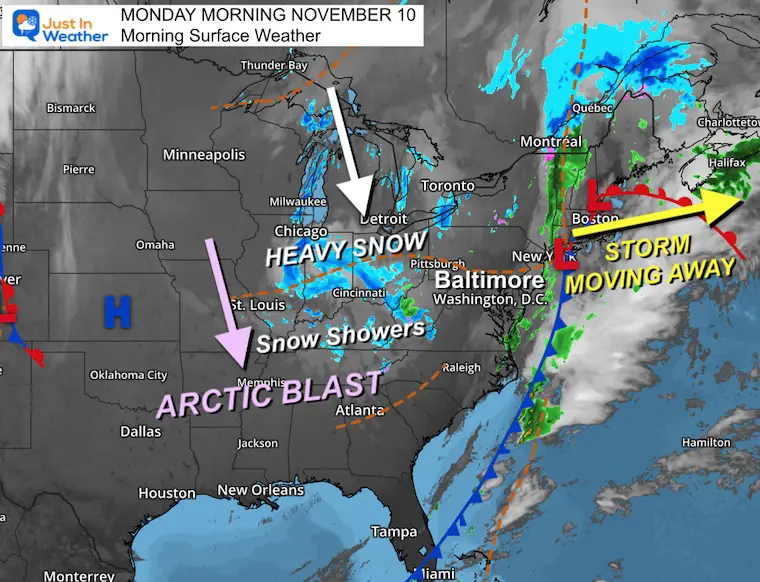
WEATHER TODAY
Surface Weather
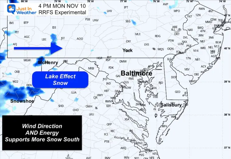
Heavy Lake Effect Snow is setting up a rare event over Lake Michigan due to the wind direction and combination of very warm water with the pre-season arctic air.
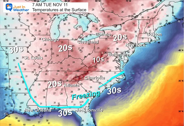
Snow will cross into the Appalachians, and freezing temps may reach the Gulf Coast by tomorrow morning.
The bulk of energy is dropping to our South!
Quick Cast
Storm Forecast Monday Morning to Wednesday Morning
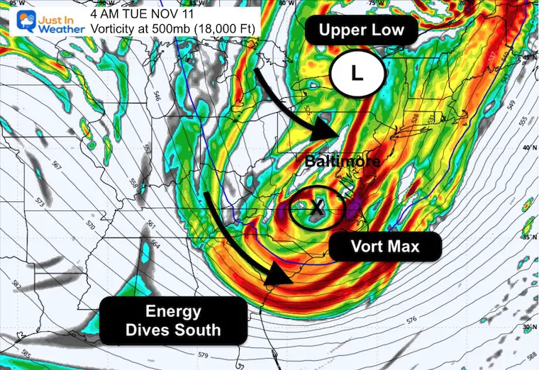
Jet Stream: Tuesday Morning Vorticity
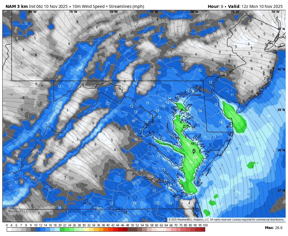
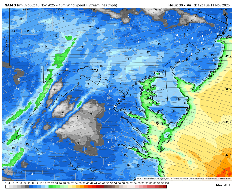
The energy will be south of Maryland. This does support some flurries or snow showers crossing over the mountains.
The best chance will be before dawn, but we could have flurries through noon.
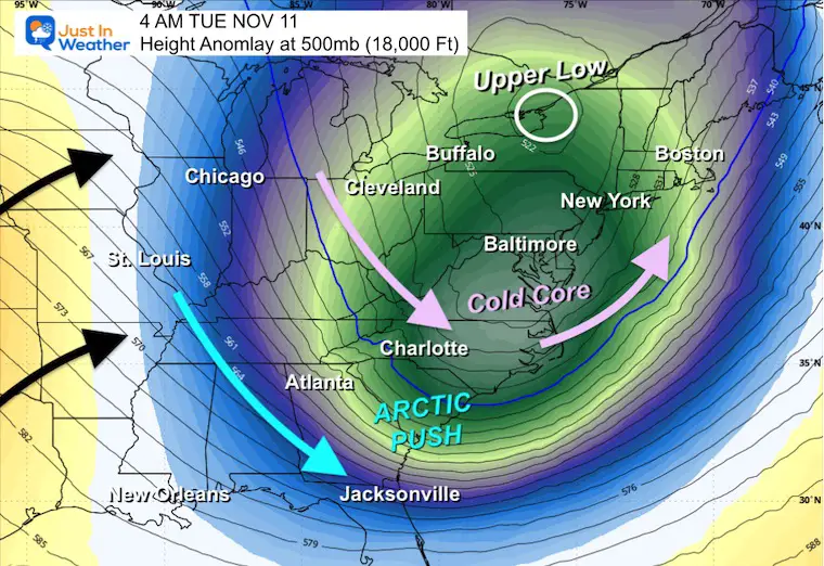
Jet Steam: Height Anomaly Tuesday Morning
The Upper Low will be in New England.
The core of the cold at this 500mb, 18,000 Ft level will pass South of Maryland.
Surface Temperatures
The FREEZE may reach the Gulf Coast. 30s will reach into Central Florida.
FORECAST TODAY
Wind Forecast 7 AM to 7 PM
Afternoon Wind Gusts
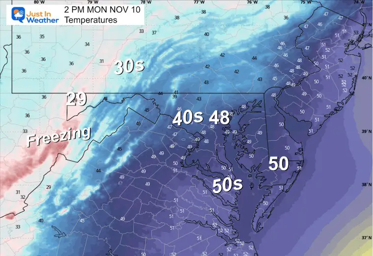
Afternoon Temperatures
Radar Simulation
Computer models AND Doppler Radar do not represent the Lake Effect snow well over the mountains. This is only a guide.
CLIMATE DATA: Baltimore
Yesterday: Low 43F; High 64F
Precipitation: 0.07” – MORE rain fell in other areas where the bands of downpours set up.
TODAY November 10
Sunrise at 6:45 AM
Sunset at 4:56 PM
Normal Low in Baltimore: 38ºF
Record 24ºF in 2003
Normal High in Baltimore: 59ºF
Record 78ºF 2020
Rainfall Deficit at BWI
- Ending 2024 = -8.00”
- Since Jan 1 = 5.75”
- We are STILL DOWN -13.75” INCLUDING LAST YEAR
My Winter Outlook For Above-Average Snow
Click here for the full report

Subscribe for eMail Alerts
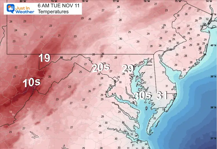
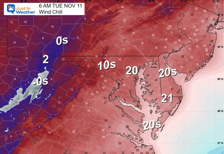
TUESDAY
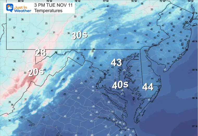
Morning Temperatures
Morning Wind Chills
Morning Wind Forecast
Flurries may reach Central Maryland…
Wind Forecast 7 AM to 7 PM
Afternoon Temperatures
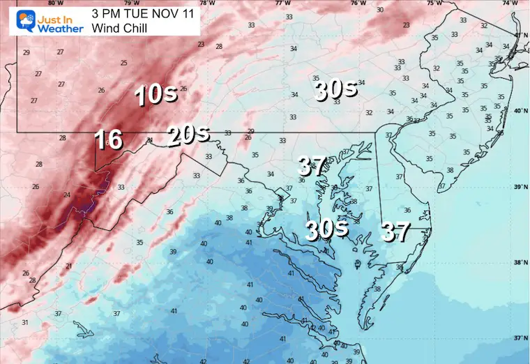
Afternoon Wind Chills
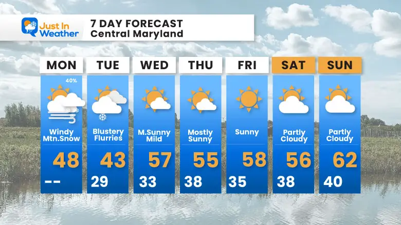
7 Day Forecast
- Next Week: Coldest Air Tuesday; Snow Flurries may reach Central and Southern Maryland
- Snow in Garrett County Mountains
- It will be COLDER inland, and snow accumulates a few inches above 2,000 Ft.
- Dry and Mild, Below Average, The Rest Of The Week
Subscribe for eMail Alerts
Average First Frost

La Niña Advisory
This was issued October 9, as expected: A weak and short-lived event to start winter may play a different role this winter

In Case You Missed It
Woolly Bear Caterpillar Winter Folklore
These are NOT all the same caterpillar!

Winter Outlook From 2 Farmers’ Almanacs

STEM Assemblies/In School Fields Trips Are Back
Click to see more and ‘Book’ a visit to your school

THANK YOU:
Baltimore Sun Magazine Readers’ Choice Best Of Baltimore

Maryland Trek 12 Day 7 Completed Sat August 9
UPDATED: We raised OVER $166,000 for Just In Power Kids – AND Still Collecting More
The annual event: Hiking and biking 329 miles in 7 days between The Summit of Wisp to Ocean City.
Each day, we honor a kid and their family’s cancer journey.
Fundraising is for Just In Power Kids: Funding Free Holistic Programs. I never have and never will take a penny. It is all for our nonprofit to operate.
Click here or the image to donate:

RESTATING MY MESSAGE ABOUT DYSLEXIA
I am aware there are some spelling and grammar typos and occasional other glitches. I take responsibility for my mistakes and even the computer glitches I may miss. I have made a few public statements over the years, but if you are new here, you may have missed it: I have dyslexia and found out during my second year at Cornell University. It didn’t stop me from getting my meteorology degree and being the first to get the AMS CBM in the Baltimore/Washington region. One of my professors told me that I had made it that far without knowing and to not let it be a crutch going forward. That was Mark Wysocki, and he was absolutely correct! I do miss my mistakes in my own proofreading. The autocorrect spell check on my computer sometimes does an injustice to make it worse. I can also make mistakes in forecasting. No one is perfect at predicting the future. All of the maps and information are accurate. The ‘wordy’ stuff can get sticky. There has been no editor who can check my work while writing and to have it ready to send out in a newsworthy timeline. Barbara Werner is a member of the web team that helps me maintain this site. She has taken it upon herself to edit typos when she is available. That could be AFTER you read this. I accept this and perhaps proves what you read is really from me… It’s part of my charm. #FITF
Please share your thoughts and best weather pics/videos, or just keep in touch via social media.


