Thursday, October 30, 2025
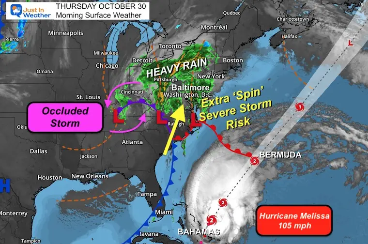
We have quite a bit of turbulence this Thursday! A strong storm has been pumping in strong winds. There is a low-level jet stream at 10,000 Ft above the ground where winds are surging to 80 mph. Considering the circulation of an occluded low-pressure system, there is a chance for individual storm cells to rotate briefly and or carry stronger winds to the surface.
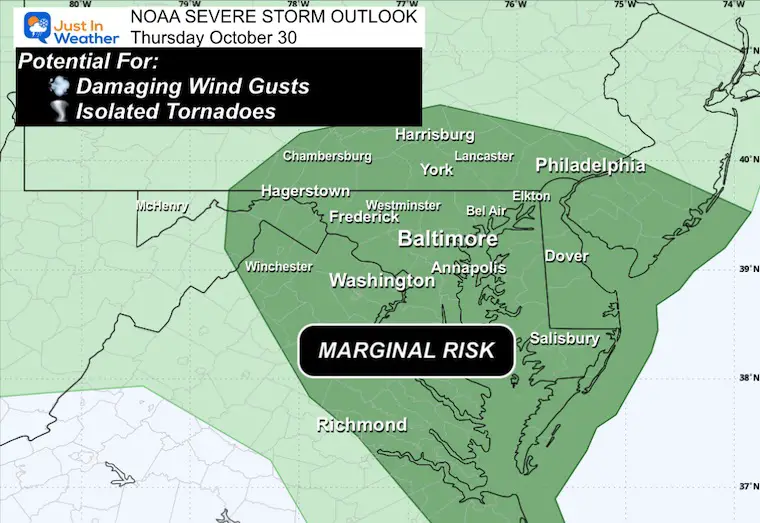
For that reason, NOAA has placed a ‘Marginal Risk’ for storms to turn severe.
The good news is that this is moving faster. Many areas have already received heavy rain up to 1 inch, with more on the way. However, the window will push the main batch through by 10 AM; then, one more band of thunderstorms could develop in the early afternoon.
Halloween will be blustery and dry, setting up the cool pattern that will remain into next week.
Hurricane Melissa is moving away from the Bahamas this morning and tracking towards Bermuda. Winds are 105 mph, making it a Category 2 and right on target with the forecast. This is moving at a forward speed of 20 mph, much faster, making for a shorter hit time.
Reminder: Daylight Saving Time ENDS this weekend, so we will set our clocks back 1 hour Saturday night.
NOAA Severe Storm Risk
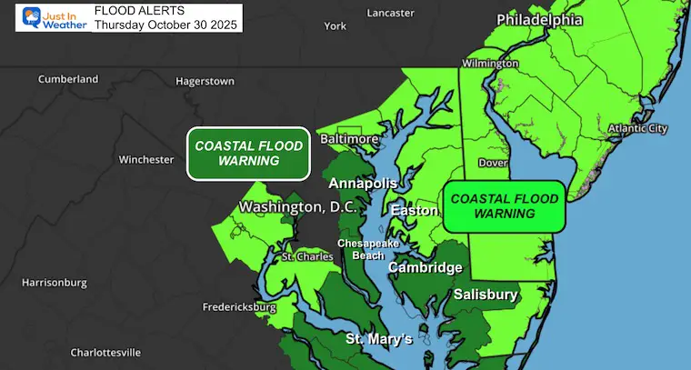
Coastal Flood Alerts
Reminder of Storm Alerts:
A Watch will be issued if there is potential for severe weather to develop.
A Warning will be issued when severe weather is occurring AND being tracked through specific towns.
Live Radar Widget
Surface Weather
The strong storm moving into the Mid-Atlantic is Occluded. This means cold air has wrapped completely around the Low-Pressure. There is a lot of spin aloft AND a new area of Low Pressure shifting the energy to the East, where a triple point of the occluded front and new branching of the warm and cold fronts. This is the portion passing through Virginia, Maryland, and Pennsylvania.
Hurricane Melissa is moving away from the Bahamas this morning and tracking towards Bermuda. Winds are 105 mph, making this a Category 2 and right on target with the forecast.
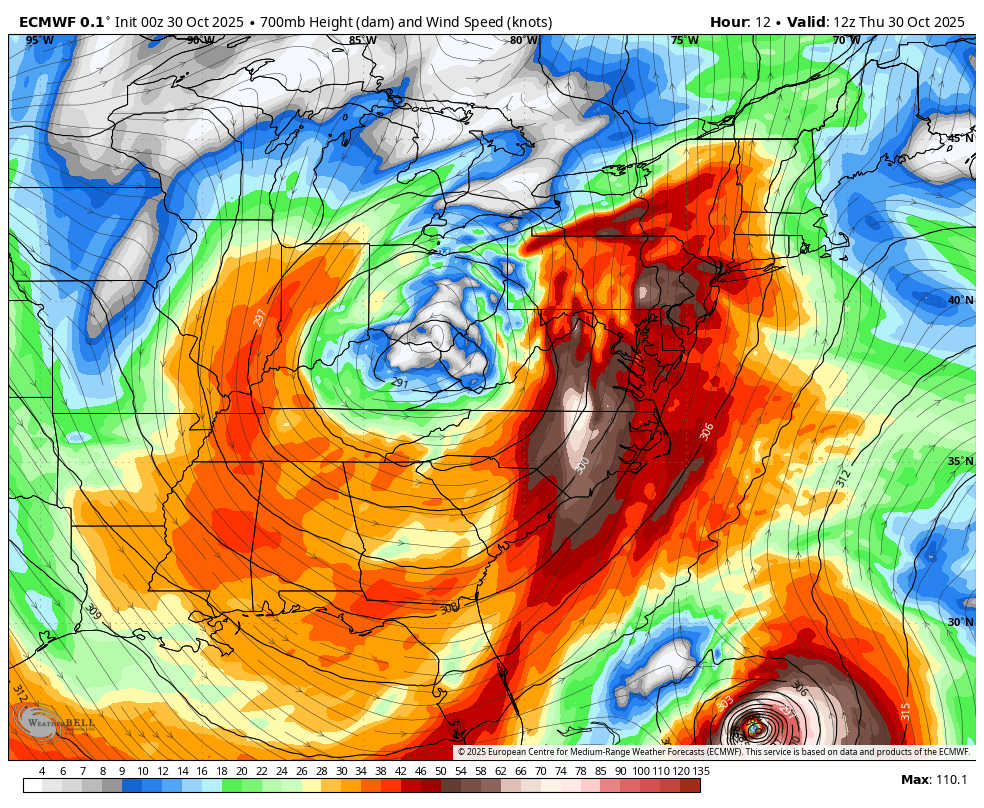
Storm Forecast Jet Stream:
700mb is around 10,000 Ft Aloft
Thursday To Friday Night
This rapid circulation shows the strong low-level jet stream FROM THE SOUTH today and then swing to THE NORTHWEST tomorrow.
Snapshots
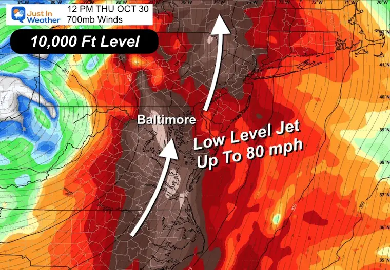
Thursday: Noon
Low-level Jet across Virginia to Central Maryland with winds up to 80 mph.
Screenshot
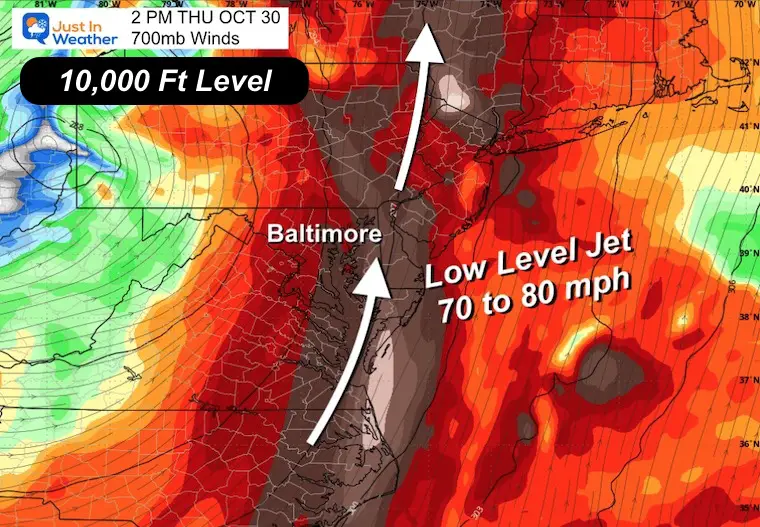
Thursday Afternoon
The Low Level Jet shifts to Delmarva with 70 to 80 mph winds.
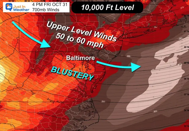
Halloween Friday
Colder air flow will be from the Northwest, at 50 to 60 mph. This will make it a blustery day!
LOCAL WEATHER TODAY
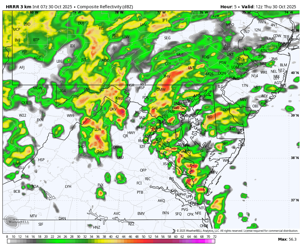
Radar Simulation Forecast 8 AM to 8 PM
This timeline is a little faster than what I showed last night.
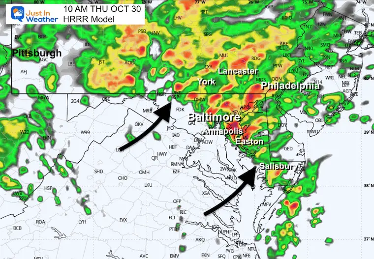
Snapshot at 10 AM
The occluded Front will pivot through Central Maryland with a fire up of strong storm cells. These may include lightning, thunder, and strong winds.
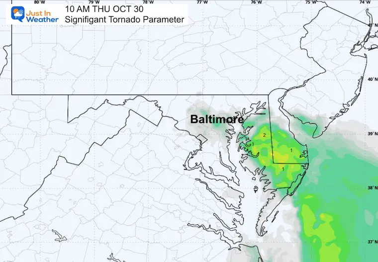
Tornado Parameter
By arriving a few hours earlier, this is not as intense as yesterday.
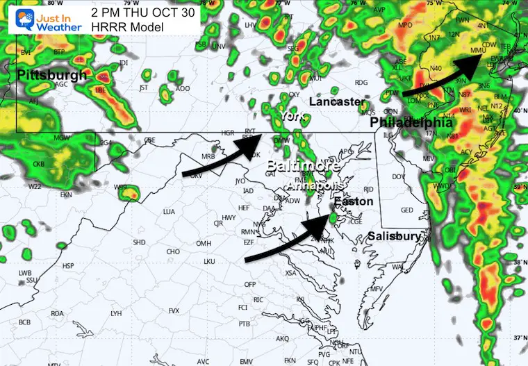
Afternoon Snapshot at 2 PM
The instabilities may ignite a few more lines of showers or thunderstorms. These still may reach severe limits.
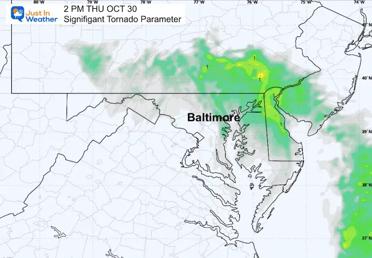
Tornado Parameter
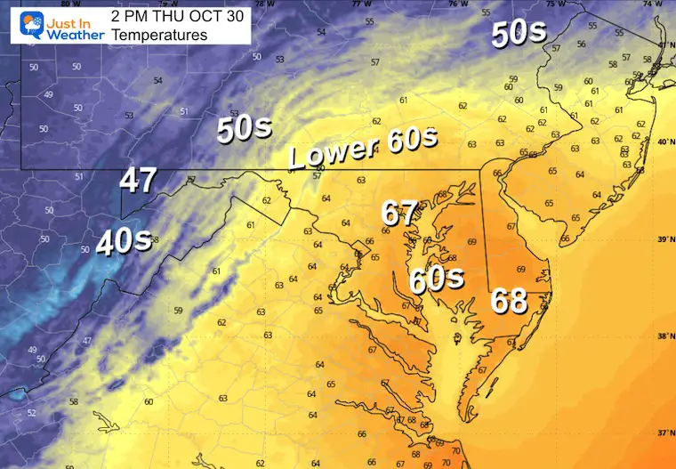
Temperatures
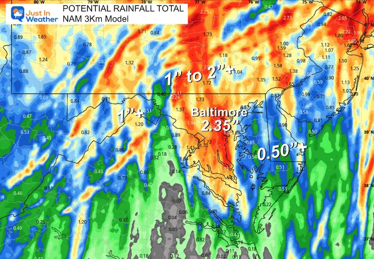
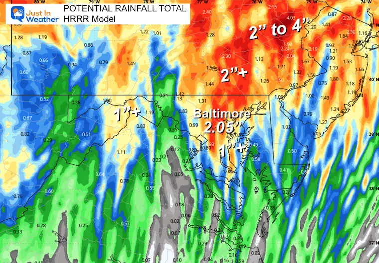
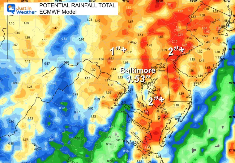
Total Rainfall Forecast Models
Note that we have already received heavy rain overnight.
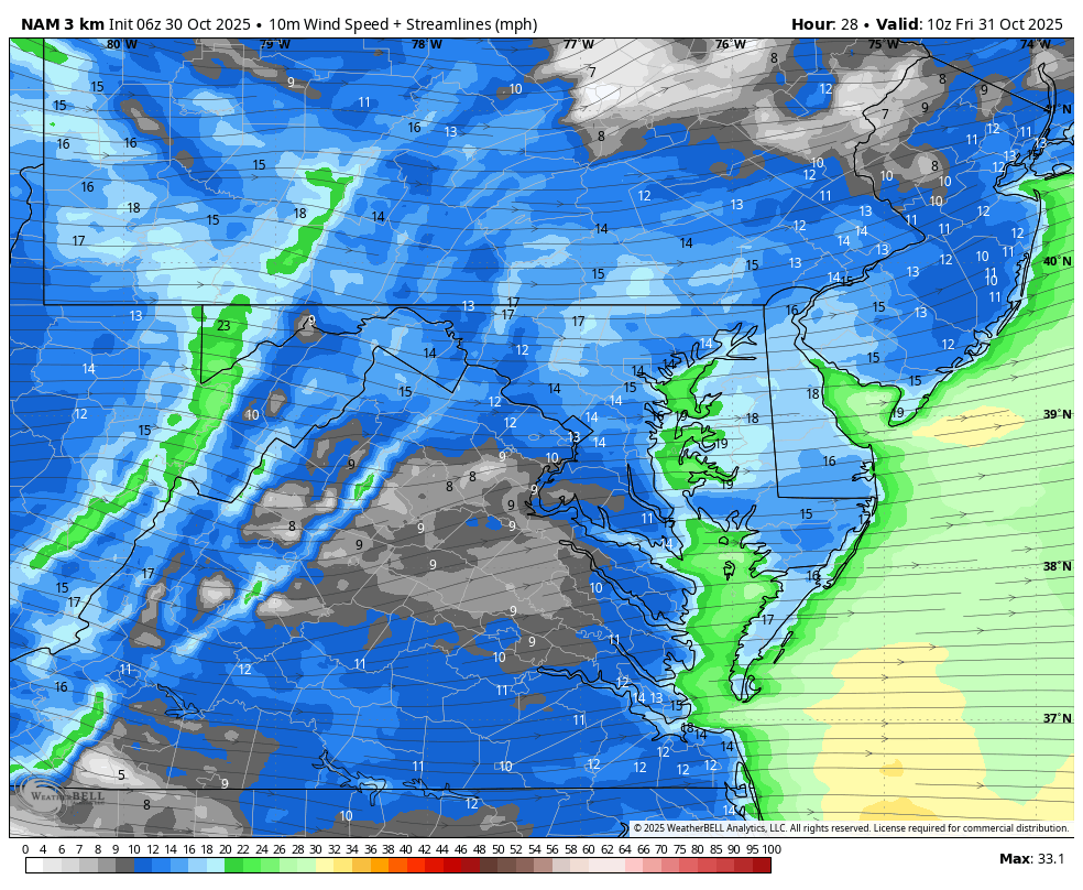
NAM 3 Km Model
HRRR Model
ECMWF Model
CLIMATE DATA: Baltimore
Yesterday: Low 49F; High 59F
Precipitation: 0.10” (up to midnight)
TODAY October 30
Sunrise at 7:32 AM
Sunset at 6:08 PM
Normal Low in Baltimore: 41ºF
Record 26ºF in 1965
Normal High in Baltimore: 63ºF
Record 83ºF 1946; 2016
Rainfall Deficit at BWI
- Ending 2024 = -8.00”
- Since Jan 1 = 6.82”
- We are STILL DOWN -14.82” INCLUDING LAST YEAR
Subscribe for eMail Alerts
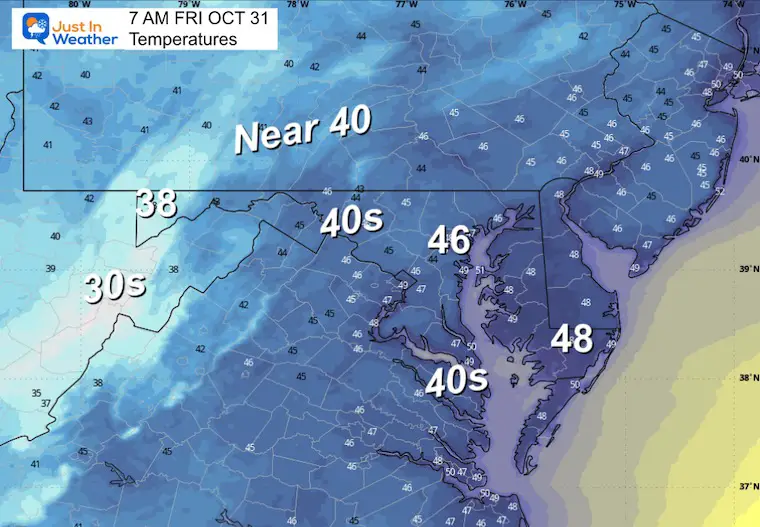
FRIDAY
Morning Temperatures
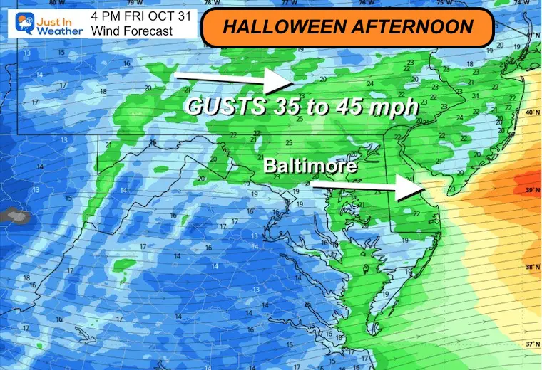
Wind Forecast 6 AM to 8 PM
Afternoon Winds
Gusts 35 to 45 mph.
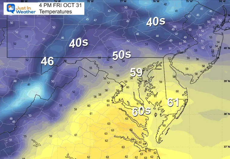
Afternoon Temperatures
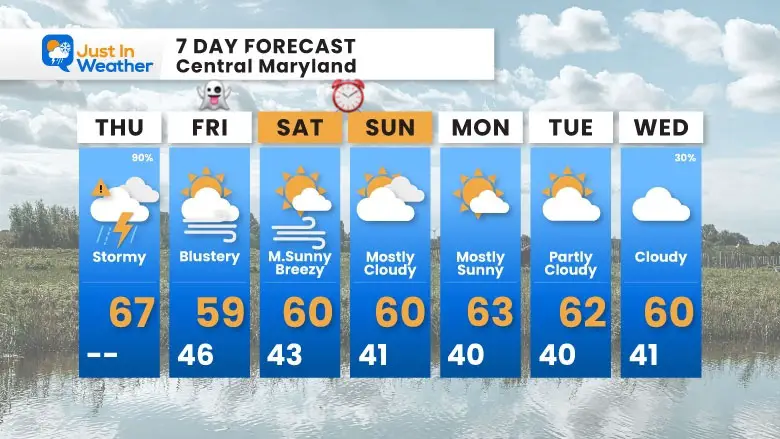
7 Day Forecast
- Today: Stormy Morning To Early Afternoon
- Halloween: Blustery Winds; Cooler
- Weekend: Dry
Subscribe for eMail Alerts
Average First Frost

La Niña Advisory
This was issued October 9, as expected: A weak and short-lived event to start winter may play a different role this winter

4 SUPERMOONS In A ROW

In Case You Missed It
Woolly Bear Caterpillar Winter Folklore
These are NOT all the same caterpillar!

Winter Outlook From 2 Farmers’ Almanacs

STEM Assemblies/In School Fields Trips Are Back
Click to see more and ‘Book’ a visit to your school

THANK YOU:
Baltimore Sun Magazine Readers’ Choice Best Of Baltimore

Maryland Trek 12 Day 7 Completed Sat August 9
UPDATED: We raised OVER $166,000 for Just In Power Kids – AND Still Collecting More
The annual event: Hiking and biking 329 miles in 7 days between The Summit of Wisp to Ocean City.
Each day, we honor a kid and their family’s cancer journey.
Fundraising is for Just In Power Kids: Funding Free Holistic Programs. I never have and never will take a penny. It is all for our nonprofit to operate.
Click here or the image to donate:

RESTATING MY MESSAGE ABOUT DYSLEXIA
I am aware there are some spelling and grammar typos and occasional other glitches. I take responsibility for my mistakes and even the computer glitches I may miss. I have made a few public statements over the years, but if you are new here, you may have missed it: I have dyslexia and found out during my second year at Cornell University. It didn’t stop me from getting my meteorology degree and being the first to get the AMS CBM in the Baltimore/Washington region. One of my professors told me that I had made it that far without knowing and to not let it be a crutch going forward. That was Mark Wysocki, and he was absolutely correct! I do miss my mistakes in my own proofreading. The autocorrect spell check on my computer sometimes does an injustice to make it worse. I can also make mistakes in forecasting. No one is perfect at predicting the future. All of the maps and information are accurate. The ‘wordy’ stuff can get sticky. There has been no editor who can check my work while writing and to have it ready to send out in a newsworthy timeline. Barbara Werner is a member of the web team that helps me maintain this site. She has taken it upon herself to edit typos when she is available. That could be AFTER you read this. I accept this and perhaps proves what you read is really from me… It’s part of my charm. #FITF
Please share your thoughts and best weather pics/videos, or just keep in touch via social media.


