Monday, October 27, 2025
Hurricane Melissa has been upgraded to a Category 5, making it the 3rd one this season in the Atlantic. This is the highest ranking level for a tropical cyclone, and it may maintain this intensity for the expected landfall tomorrow morning. This will inevitably lead to mass destruction in Jamaica.
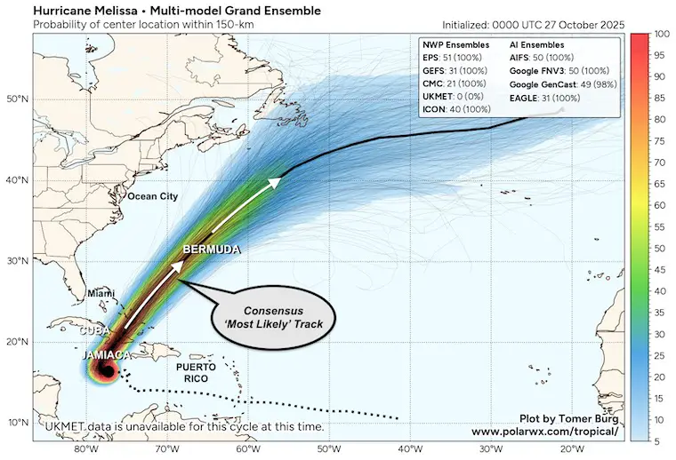
We have a very active week ahead as we watch a stormy pattern set up for the Eastern US, AND Hurricane Melissa makes landfall on Jamaica tomorrow. These two are connected and will force the hurricane to pull north into the Atlantic with possible impact on Bermuda.
Locally, we expect a larger storm complex to bring us rain later in the work week. That will keep Melissa well off the East Coast AND THEN reinforce the cold air into November.
We will start with the Tropics…..
TROPICAL OUTLOOK
From the National Hurricane Center:
DESTRUCTIVE WINDS AND STORM SURGE AND CATASTROPHIC FLOODING WILL WORSEN ON JAMAICA THROUGH THE DAY AND INTO TONIGHT…
2025 Atlantic Category 5 Storms
- Erin on Aug 11 Pressure 915 mb
- Humberto on Sep 25 Pressure 924 mb
- Melissa on Oct 27 Pressure 917 mb
HURRICANE MELISSA
Category 5 with 160 mph winds. This is a small storm as hurricane-force winds reach only 30 miles from the center. Tropical Storm force winds reach 195 miles away.
This is crawling to the West at 3 mph, with a turn to the North expected today. Landfall on Jamaica through the central part of the island on Tuesday morning, then it will speed up as it moves into the Central Atlantic, passing close to Bermuda. It will be weaker at that point, but still a dangerous system.
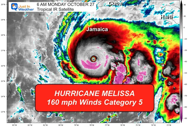
National Hurricane Center Report: 5 AM Monday Morning
- LOCATION…16.4N 77.8W
- ABOUT 130 MI…205 KM SSW OF KINGSTON JAMAICA
- ABOUT 315 MI…505 KM SSW OF GUANTANAMO CUBA
- MAXIMUM SUSTAINED WINDS…160 MPH…260 KM/H
- PRESENT MOVEMENT…W OR 275 DEGREES AT 3 MPH…6 KM/H
- MINIMUM CENTRAL PRESSURE…917 MB…27.08 INCHES
Satellite Loop
The light steering winds will allow a crawl over very warm water. This has allowed rapid development to major hurricane intensity.
There is ample warm water that runs deep, so upwelling is not expected to be a factor for cooling. 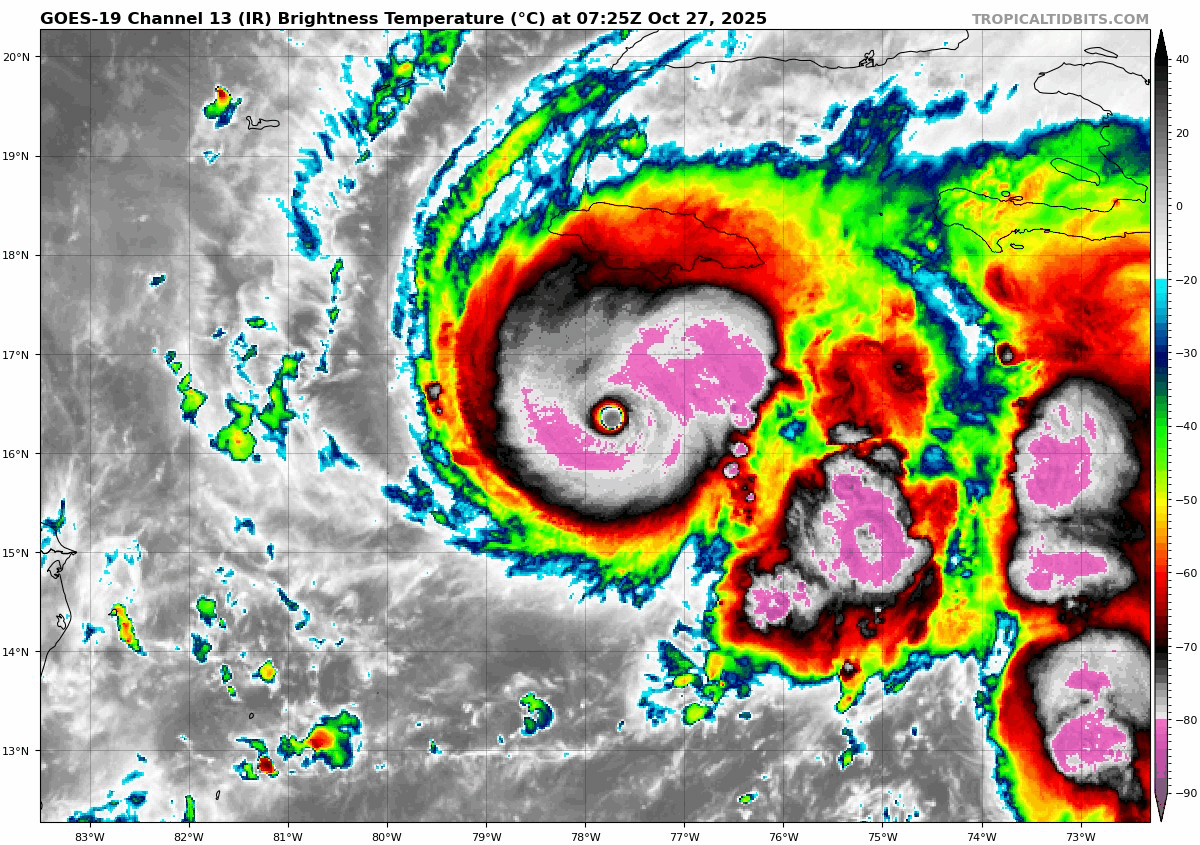
National Hurricane Center Forecast Track
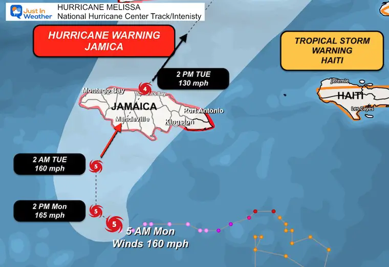
SUMMARY OF WATCHES AND WARNINGS IN EFFECT:
A Hurricane Warning is in effect for…
- Jamaica
- Cuban provinces of Granma, Santiago de Cuba, Guantanamo, and Holguin.
A Hurricane Watch is in effect for…
- Southeastern and central Bahamas
- Turks and Caicos Islands
A Tropical Storm Warning is in effect for…
- Cuban province of Las Tunas
CLOSE UP TRACK ON JAMAICA
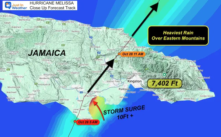
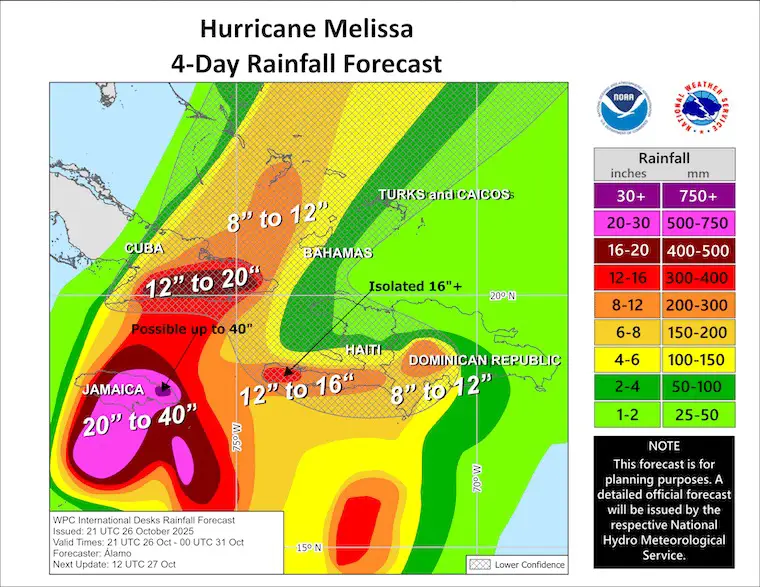
Rainfall Forecast: Only Out To 4 Days
The National Hurricane Center is picking up the ECMWF Model forecast…
20 to 40 inches expected for the eastern half of Jamaica.
Computer Model Forecast Tracks
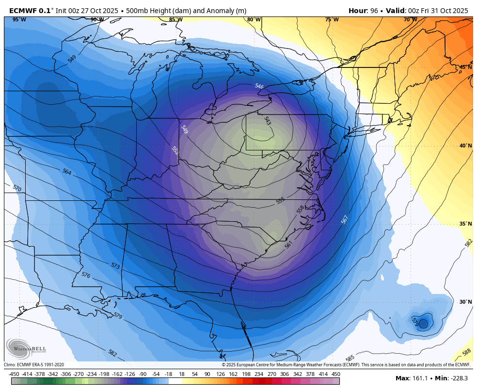
These all show the kick out into the Atlantic and close to Bermuda… but NOT a US mainland storm. Our local storm and push of colder air will protect us.
Note: The stronger side of the storm is on the ‘right side’ of forward movement. The precise track may shift for landfall and crossing the island.
LOCAL WEATHER
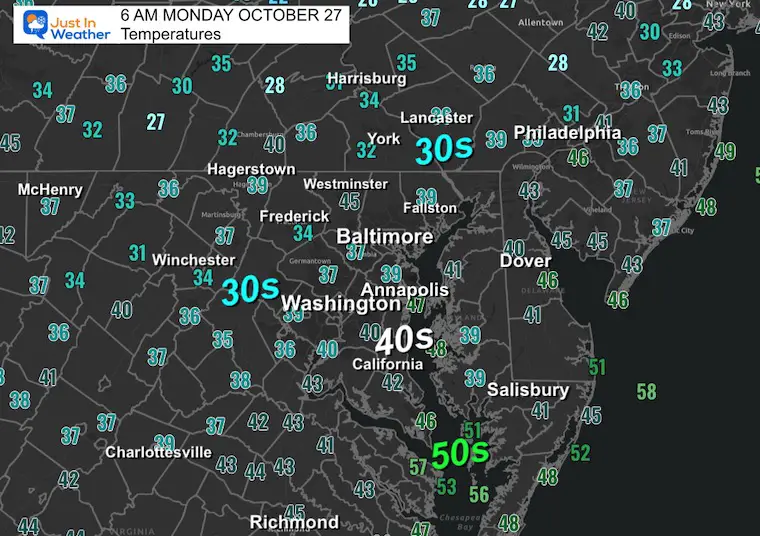
Morning Temperatures
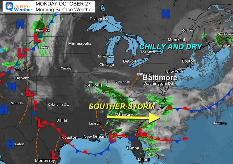
Surface Weather
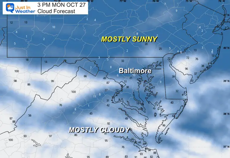
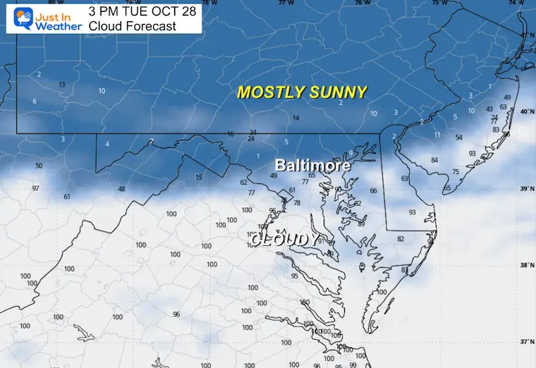
Afternoon Cloud Forecast
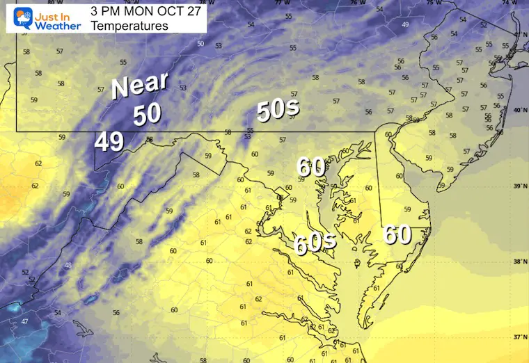
Afternoon Temperatures
CLIMATE DATA: Baltimore
Yesterday: Low 36F; High 62F
Precipitation: 0.00” (up to midnight)
TODAY October 27
Sunrise at 7:29 AM
Sunset at 6:11 PM
Normal Low in Baltimore: 42ºF
Record 29ºF in 1962; 1988
Normal High in Baltimore: 64ºF
Record 82ºF 1963
Rainfall Deficit at BWI
- Ending 2024 = -8.00”
- Since Jan 1 = 6.56”
- We are STILL DOWN -14.56” INCLUDING LAST YEAR
Subscribe for eMail Alerts
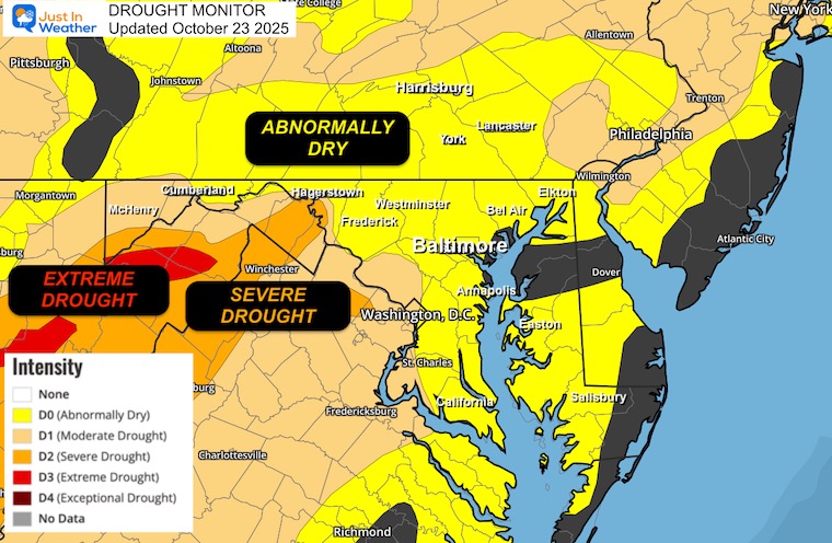
Drought Monitor Update
The need for rain has been highlighted and may be underrepresented in some spots.
We need rain.
TUESDAY
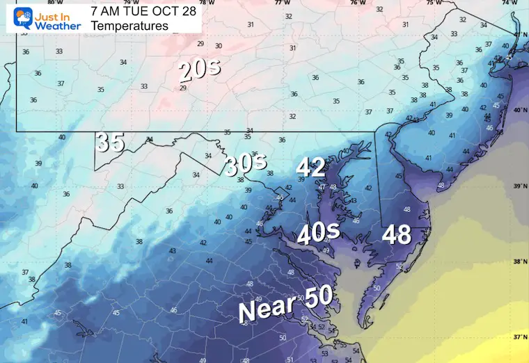
Morning Temperatures
Afternoon Cloud Forecast
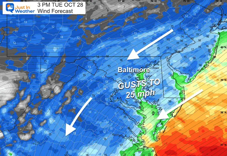
Afternoon Wind Forecast
Winds will increase FROM the Northeast with gusts up to 25 mph as a storm passes to our south.
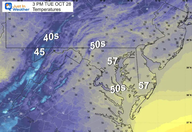
Afternoon Temperatures
Looking Ahead:
Tuesday Afternoon Forecast
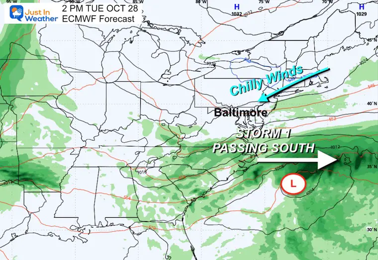
A storm passing through the Southeast US will bring a cloudy day south of Baltimore while increasing the winds across the region.
 ]
]
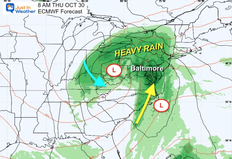
Storm Forecast: Tuesday to Thursday Night
The Operational European Model keeps the lead on this storm development. There will be two waves, with the first passing to our south with rain, but clouds may reach the sky near and south of Baltimore on Tuesday.
The second wave will include two parts, a coastal Low and a larger impulse injected from the Central Plains. They will merge into a larger East Coast Storm Complex.
The timing places us with the best chance of rain Wednesday night into Thursday. Even cold enough for snow on the high summits of West Virginia.
This will move out before Halloween with cold, dry winds filling in….
Rain will fall across the Great Lakes and into New England. This is also helping to protect us from Hurricane Melissa.
Snapshots
Thursday Morning
A rainy day with the prime pump of moisture passing through our region.
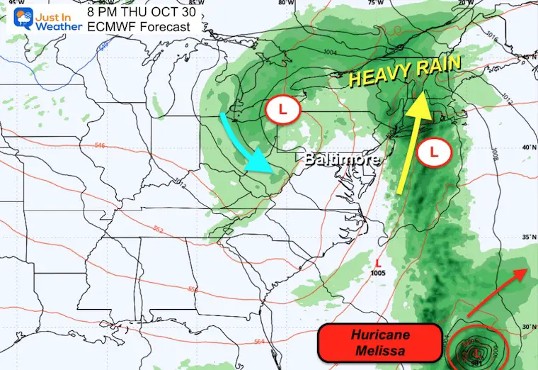
Thursday Night
Rainfall will shift to New England as we get into the dry slot of this larger complex. Hurricane Melissa is seen well off the US coast and moving away from the mainland.
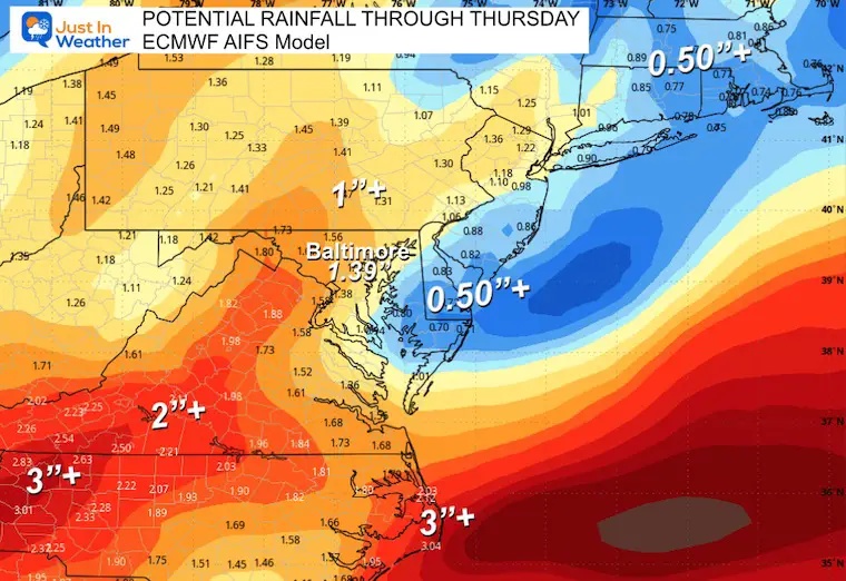
Rainfall Potential
The ECMWF AI Model seems to me to be the most likely result.
Most of our region can expect to receive between 1 and 2 inches of rain.
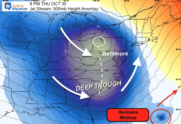
Jet Stream Thursday
The DEEP TROUGH will swing through behind the storm and dig far south. This will bring chilly air to Florida AND help pull Hurricane Melissa into the Atlantic.
Jet Stream: Thursday October 30 to Monday, November 3
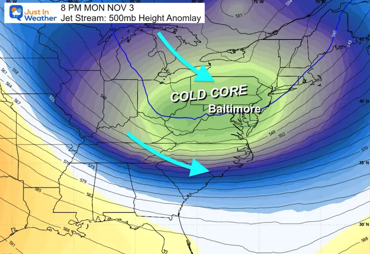
Jet Stream Next Monday
The next COLD CORE will settle in and may produce the first snow of the season for parts of the Great Lakes and higher summits in the Allegheny Mountains of Western Maryland and West Virginia.
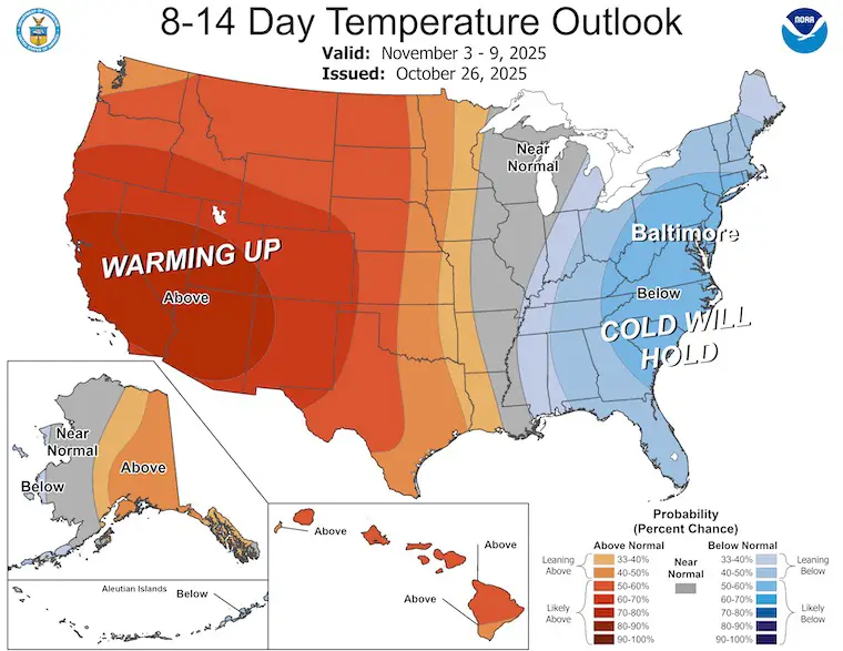
NOAA Temperature Outlook To 2 Weeks
The Cold will hold here in the Eastern US.
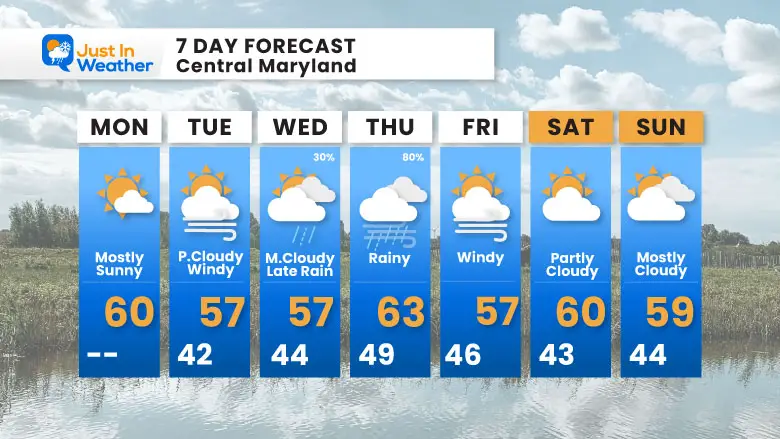
7 Day Forecast
- Temps REMAIN Below Average
- Next Week: Rain is most likely on Thursday
- Halloween: Cold Winds and Dry
Subscribe for eMail Alerts
Average First Frost

La Niña Advisory
This was issued October 9, as expected: A weak and short-lived event to start winter may play a different role this winter

4 SUPERMOONS In A ROW

In Case You Missed It
Woolly Bear Caterpillar Winter Folklore
These are NOT all the same caterpillar!

Winter Outlook From 2 Farmers’ Almanacs

STEM Assemblies/In School Fields Trips Are Back
Click to see more and ‘Book’ a visit to your school

THANK YOU:
Baltimore Sun Magazine Readers’ Choice Best Of Baltimore

Maryland Trek 12 Day 7 Completed Sat August 9
UPDATED: We raised OVER $166,000 for Just In Power Kids – AND Still Collecting More
The annual event: Hiking and biking 329 miles in 7 days between The Summit of Wisp to Ocean City.
Each day, we honor a kid and their family’s cancer journey.
Fundraising is for Just In Power Kids: Funding Free Holistic Programs. I never have and never will take a penny. It is all for our nonprofit to operate.
Click here or the image to donate:

RESTATING MY MESSAGE ABOUT DYSLEXIA
I am aware there are some spelling and grammar typos and occasional other glitches. I take responsibility for my mistakes and even the computer glitches I may miss. I have made a few public statements over the years, but if you are new here, you may have missed it: I have dyslexia and found out during my second year at Cornell University. It didn’t stop me from getting my meteorology degree and being the first to get the AMS CBM in the Baltimore/Washington region. One of my professors told me that I had made it that far without knowing and to not let it be a crutch going forward. That was Mark Wysocki, and he was absolutely correct! I do miss my mistakes in my own proofreading. The autocorrect spell check on my computer sometimes does an injustice to make it worse. I can also make mistakes in forecasting. No one is perfect at predicting the future. All of the maps and information are accurate. The ‘wordy’ stuff can get sticky. There has been no editor who can check my work while writing and to have it ready to send out in a newsworthy timeline. Barbara Werner is a member of the web team that helps me maintain this site. She has taken it upon herself to edit typos when she is available. That could be AFTER you read this. I accept this and perhaps proves what you read is really from me… It’s part of my charm. #FITF
Please share your thoughts and best weather pics/videos, or just keep in touch via social media.


