Friday October 24 2025
The weather map is active and we have a lot expected over the next week.
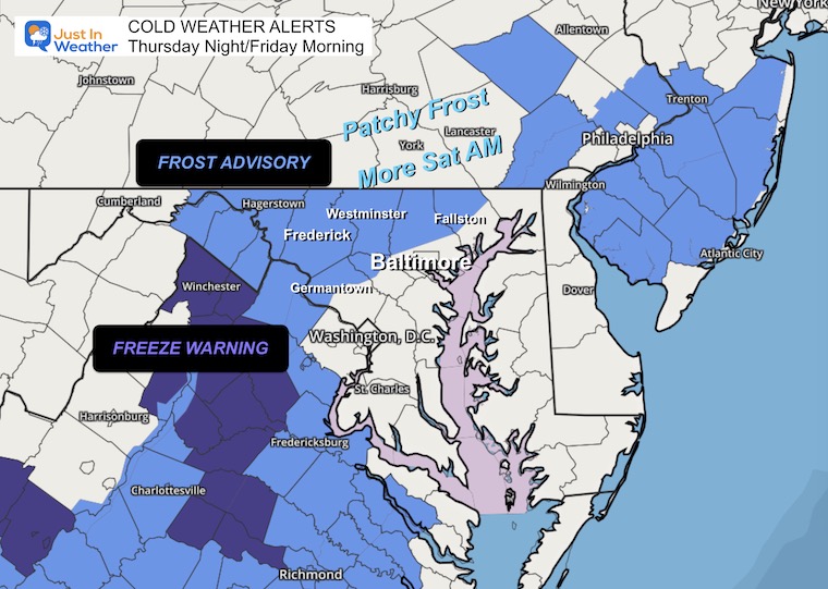
The short version is that we are stuck in a colder pattern. Temps will remain below average and this may include expanded Frost Advisories tomorrow morning.
A busy storm pattern will set up and could bring us to hits of rain next week. The second one will be the bigger one. That will arrive Thursday and Halloween Friday with heavier rain and colder air.
That is also expected to take Melissa as a major hurricane out of the Caribbean and into the Central Atlantic, missing the US mainland.
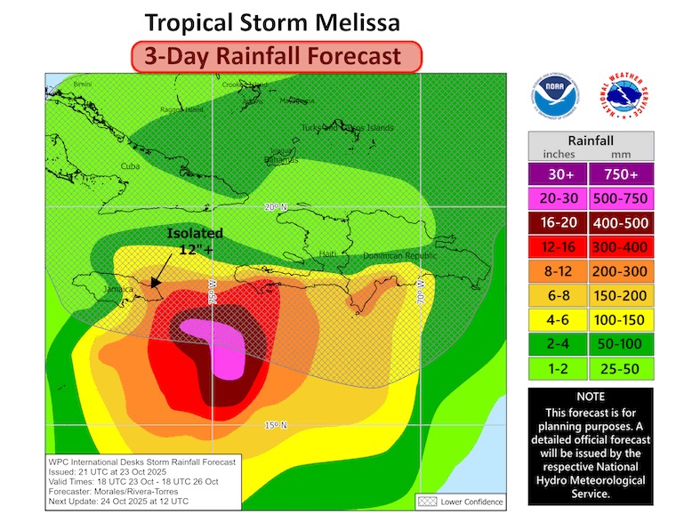
The concern for Melissa on Jamaica is real! Later this weekend rapid development may push this to Category 4 or higher with a pounding of heavy rain on the island nation for many days. The rainfall total may be measured in a few feet.
Let’s take a look…
Frost and Freeze Alerts This Morning
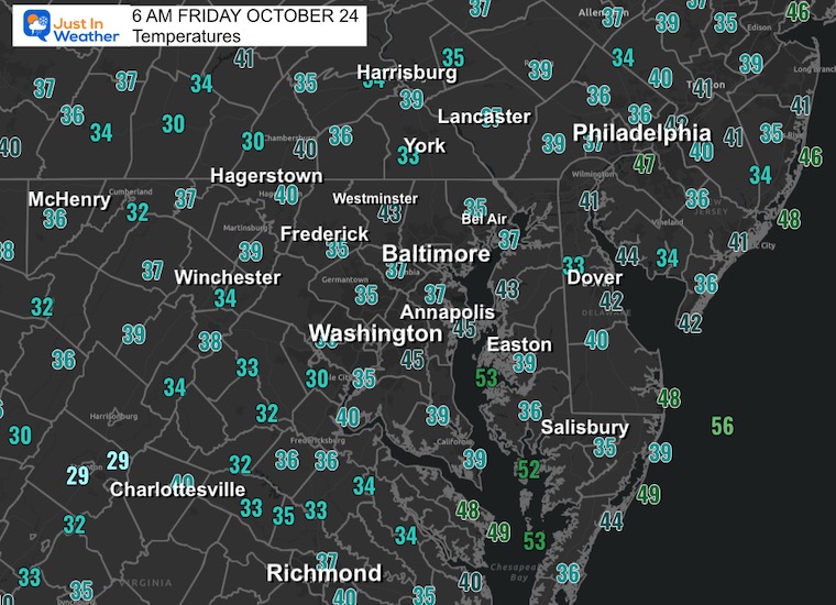
Morning Temperatures
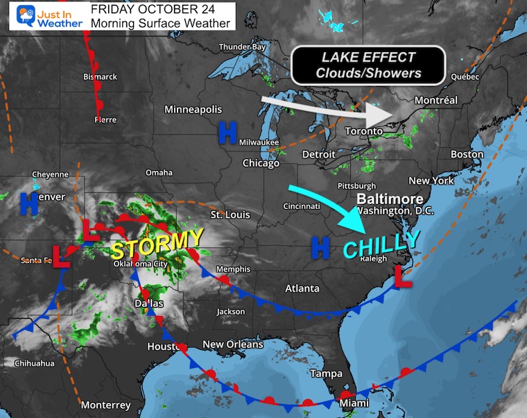
Surface Weather
A lot of activity and dare I say a ‘winter look’?
The chilly air has expanded across the Eastern US.
Great Lakes instability will continue to provide clouds and locally heavy band of rain (this time).
A new storm is developing in the Southern Plains and will start the track of a few systems to the East Coast.
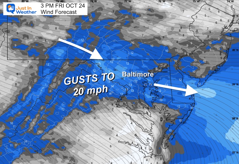
Wind Forecast 8 AM to 8 PM
Afternoon Wind Forecast
Gusts over 20 mph
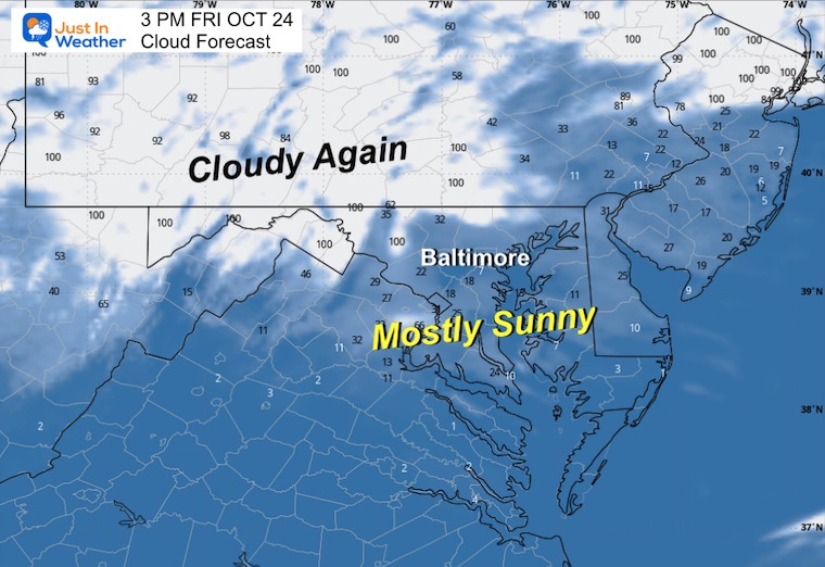
Afternoon Cloud Forecast
The influence of daytime clouds will again form over the mountains and inland hills west and north.
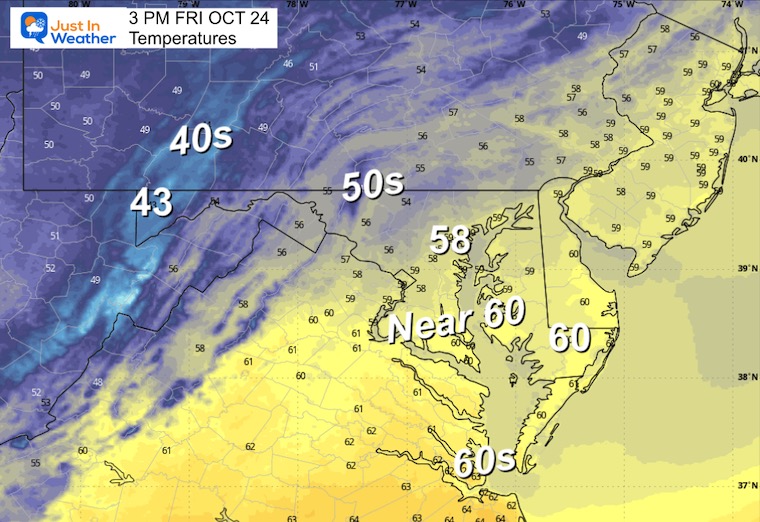
Afternoon Temperatures
Fall Foliage Update
CLIMATE DATA: Baltimore
Yesterday: Low 44F; High 66F
Precipitation: 0.00” (up to midnight)
TODAY October 24
Sunrise at 7:26 AM
Sunset at 6:15 PM
Normal Low in Baltimore: 43ºF
Record 25ºF in 1969
Normal High in Baltimore: 66ºF
Record 82ºF 2001
Rainfall Deficit at BWI
- Ending 2024 = -8.00”
- Since Jan 1 = 6.20”
- We are STILL DOWN -14.20” INCLUDING LAST YEAR
Subscribe for eMail Alerts
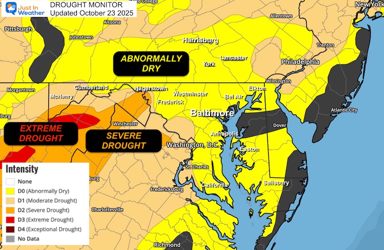
Drought Monitor Update
The need for rain has been highlighted and may be underrepresented in some spots.
We need rain.
SATURDAY
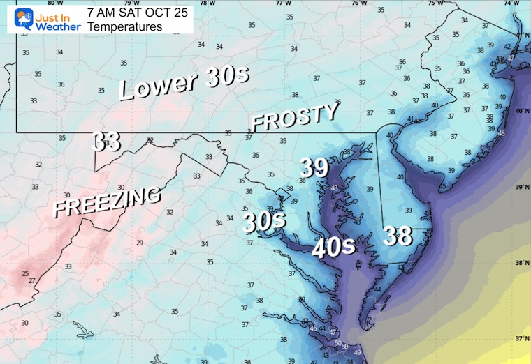
Morning Temperatures
The Frost and Freeze Alerts are expected to be expanded to more areas.
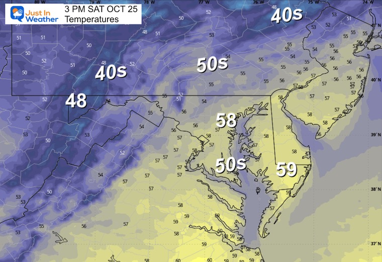
Afternoon Temperatures
Looking Ahead:
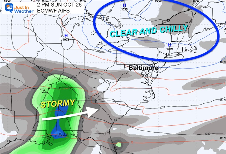
Storm Forecast: Sunday to Friday
This is the AI Version of the European Model. I highlight that because it does differ from the operational models, but has been performing best, so I will focus on this:
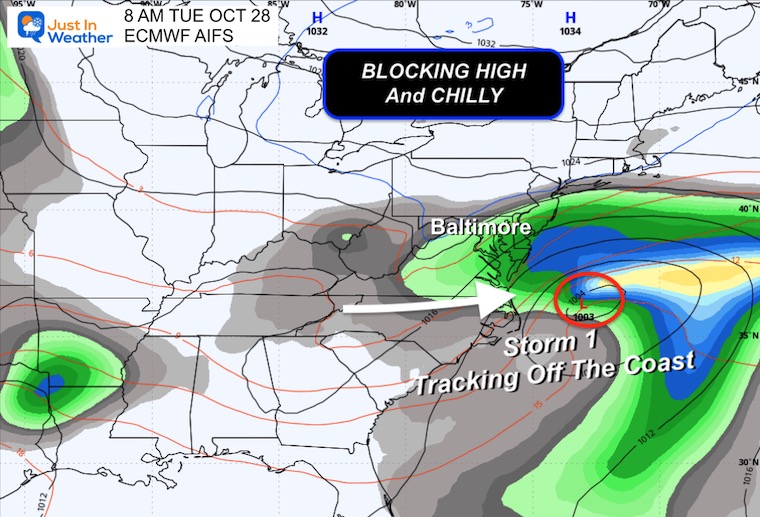
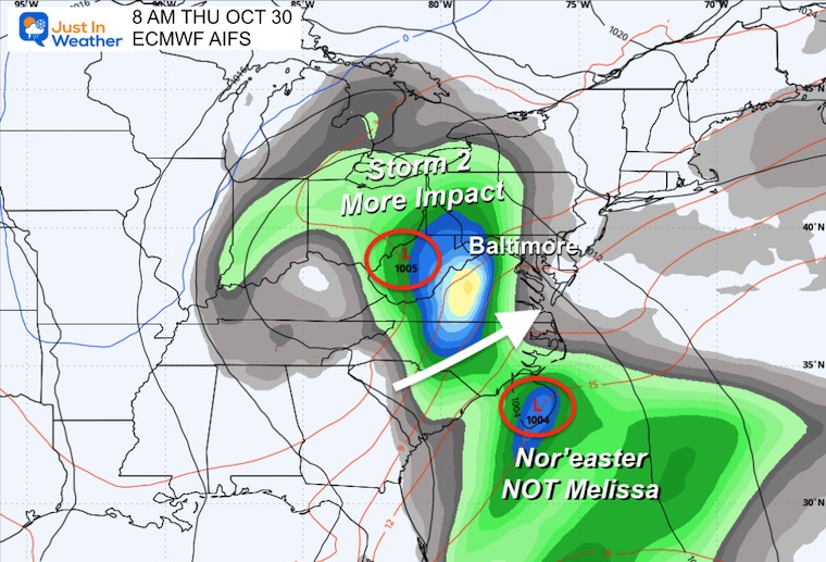
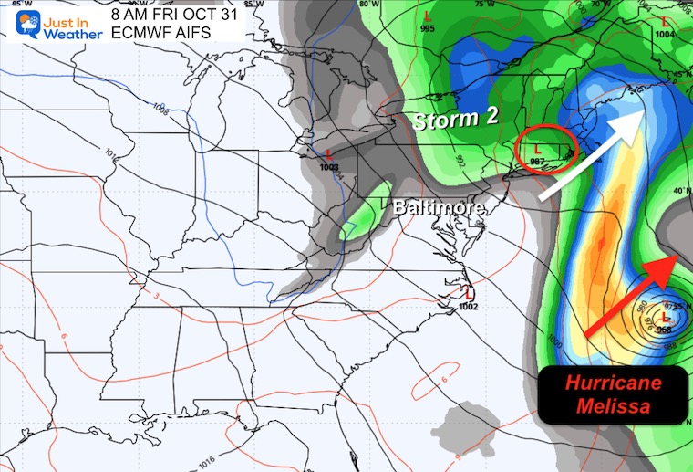
Here we see two systems. One tracking just south and then off the coast mid-week. The second will be with the upper-level cold-core Low. This may bring the rain on Thursday into Friday morning. It will kick Hurricane Melissa out of the Caribbean and into the Central Atlantic.
Snapshots
Sunday October 26
Tuesday October 28
Thursday October 30
Friday October 31
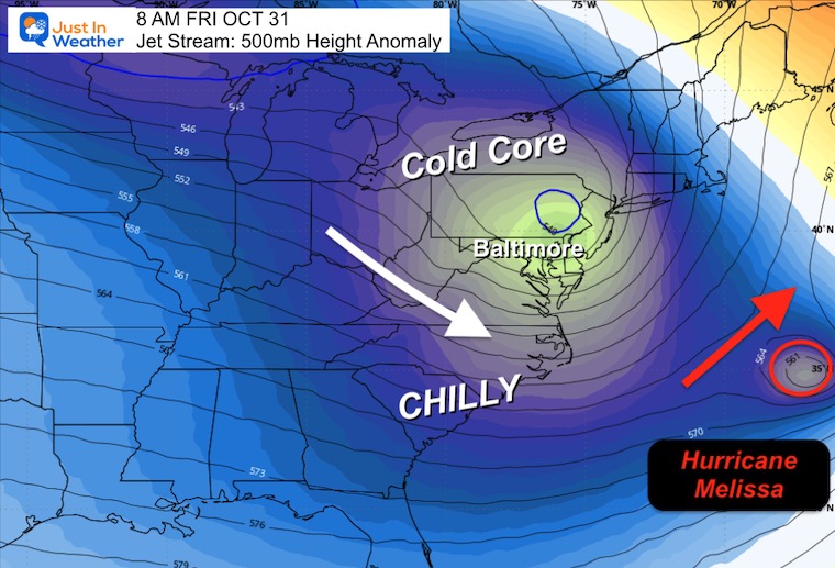
Jet Stream: Friday, October 31
Tropical Outlook
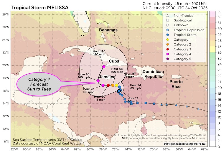
Tropical Storm Melissa’s winds have decreased to 45 mph.
The light steering winds will allow a stall and crawl over very warm water. This will encourage rapid development to major hurricane intensity.
There is ample warm water that runs deep, so upwelling is not expected to be a factor for cooling. Essentially, there is plenty of energy for this to feed off.
Satellite Loop
SUMMARY OF 500 AM EDT…0900 UTC…INFORMATION
———————————————-
- LOCATION…16.0N 75.5W
- ABOUT 165 MI…260 KM SSE OF KINGSTON JAMAICA
- ABOUT 275 MI…445 KM SW OF PORT AU PRINCE HAITI
- MAXIMUM SUSTAINED WINDS…45 MPH…75 KM/H
- PRESENT MOVEMENT…STATIONARY
- MINIMUM CENTRAL PRESSURE…1001 MB…29.56 INCHES
National Hurricane Center Forecast Track
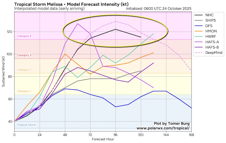
More Detailed Look: Thanks to Tomer Burg
This is expected to become a Category 4 Hurricane later this weekend as it stalls or crawls to the south side of Jamaica.
Model Forecast Intensity
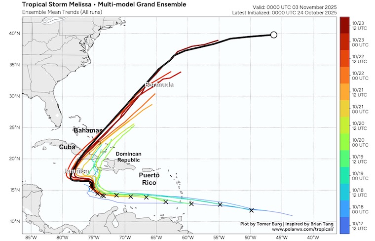
Computer Model Forecast Tracks
These all show the kick out into the Atlantic and close to Bermuda… but NOT a US mainland storm. Our local storm and push of colder air will protect us.
Rainfall Forecast: Only Out To 3 Days
Heavy rain may be enhanced even more over the mountains on these islands. The final total could easily be double or triple this over Jamaica and the Turks and Caicos.
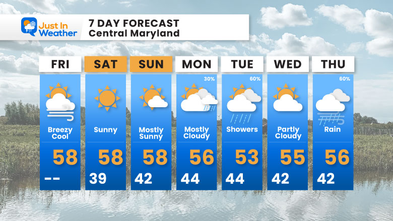
7 Day Forecast
- Today: Cool Wind And Inland Clouds
- Frosty Mornings With Daytime Sun
- Temps REMAIN Below Average
- Sunday: Chilly For The Ravens Home Game
- Next Week: Pattern Change Brings Rain
Subscribe for eMail Alerts
Average First Frost

La Niña Advisory
This was issued October 9, as expected: A weak and short-lived event to start winter may play a different role this winter

4 SUPERMOONS In A ROW

In Case You Missed It
Woolly Bear Caterpillar Winter Folklore
These are NOT all the same caterpillar!

Winter Outlook From 2 Farmers’ Almanacs

STEM Assemblies/In School Fields Trips Are Back
Click to see more and ‘Book’ a visit to your school

THANK YOU:
Baltimore Sun Magazine Readers’ Choice Best Of Baltimore

Maryland Trek 12 Day 7 Completed Sat August 9
UPDATED: We raised OVER $166,000 for Just In Power Kids – AND Still Collecting More
The annual event: Hiking and biking 329 miles in 7 days between The Summit of Wisp to Ocean City.
Each day, we honor a kid and their family’s cancer journey.
Fundraising is for Just In Power Kids: Funding Free Holistic Programs. I never have and never will take a penny. It is all for our nonprofit to operate.
Click here or the image to donate:

RESTATING MY MESSAGE ABOUT DYSLEXIA
I am aware there are some spelling and grammar typos and occasional other glitches. I take responsibility for my mistakes and even the computer glitches I may miss. I have made a few public statements over the years, but if you are new here, you may have missed it: I have dyslexia and found out during my second year at Cornell University. It didn’t stop me from getting my meteorology degree and being the first to get the AMS CBM in the Baltimore/Washington region. One of my professors told me that I had made it that far without knowing and to not let it be a crutch going forward. That was Mark Wysocki, and he was absolutely correct! I do miss my mistakes in my own proofreading. The autocorrect spell check on my computer sometimes does an injustice to make it worse. I can also make mistakes in forecasting. No one is perfect at predicting the future. All of the maps and information are accurate. The ‘wordy’ stuff can get sticky. There has been no editor who can check my work while writing and to have it ready to send out in a newsworthy timeline. Barbara Werner is a member of the web team that helps me maintain this site. She has taken it upon herself to edit typos when she is available. That could be AFTER you read this. I accept this and perhaps proves what you read is really from me… It’s part of my charm. #FITF
Please share your thoughts and best weather pics/videos, or just keep in touch via social media.


