Thursday, October 16, 2025
This setup actually works out well for us. The cool air is settling in to end the work week, only to be followed by a warm-up for a mostly dry weekend. The next chance for rain is most likely to arrive late in the day or evening on Sunday.
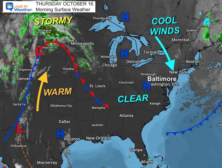
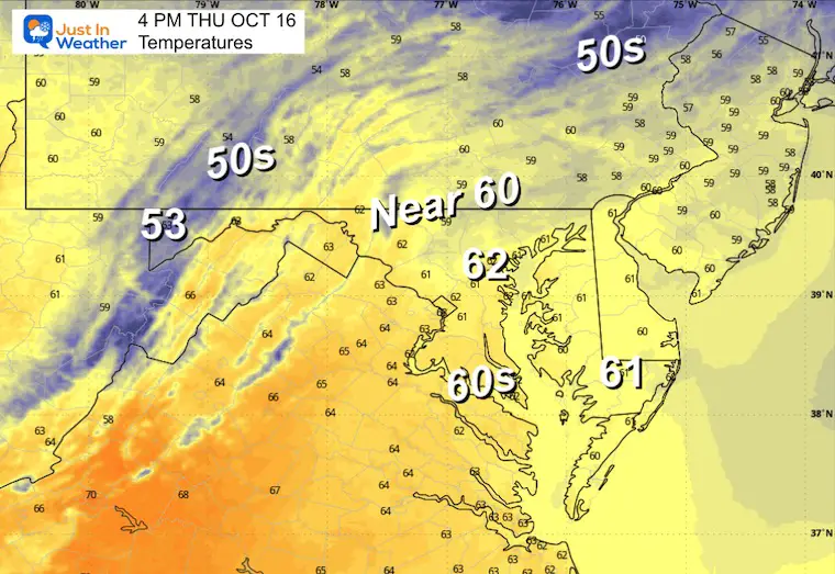
This morning, the sky is clear and we still have a North wind that will keep most areas chilly from the upper 50s inland to the lower 60s.
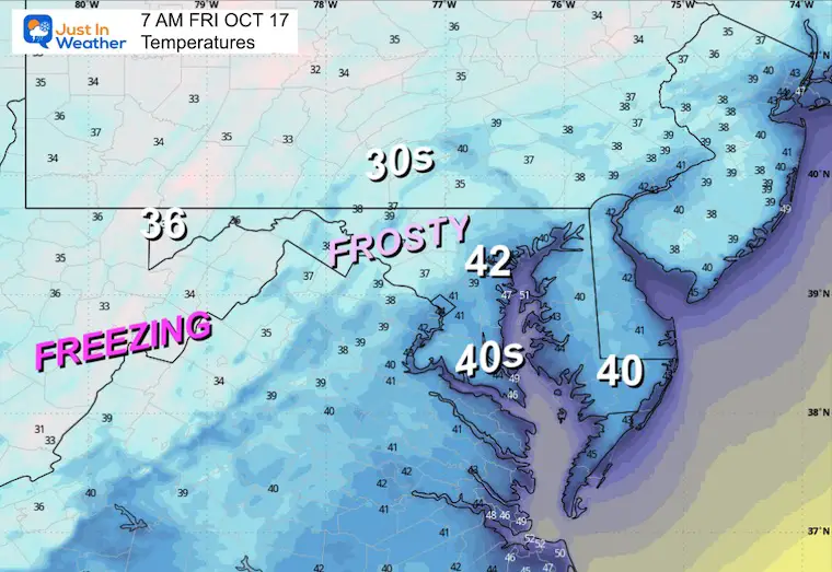
Overnight and Friday morning, inland areas will get another frost as the winds settle down.
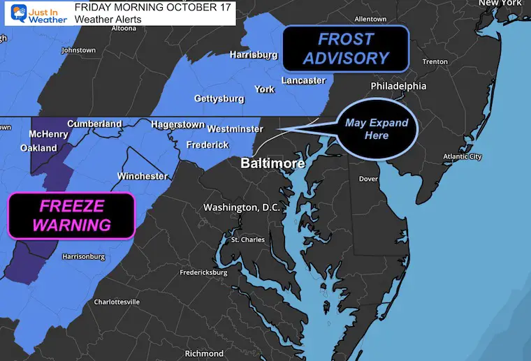
FROST AND FREEZE FRIDAY MORNING
Here are the latest alerts issued by the National Weather Service. They go into effect tonight, and I suspect they may get expanded to include northern Baltimore and Harford Counties as well.
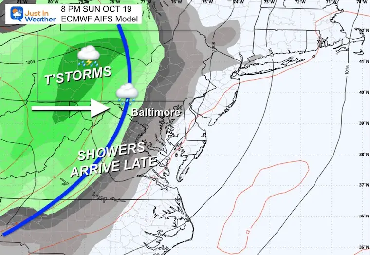
This weekend we warm back up close to 70F, with Sunday being warmer, then a line of rain and thunderstorms arrives late.
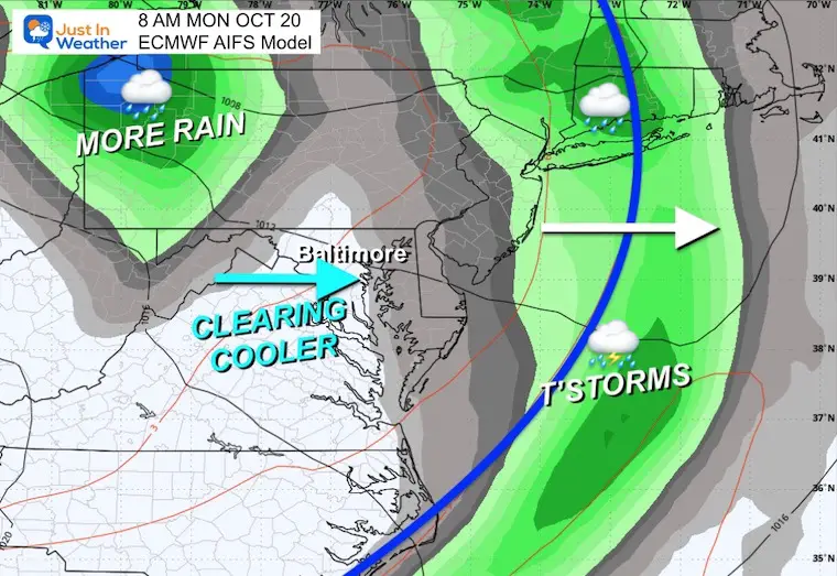
I am seeing a possible pattern develop as that next cold front may help spawn a new Coastal Low that sets up early next week. This may miss us and reach New England, but worth watching for helping to pull down more cooler air for us.
Next Week will have frequent impulses to reinforce the cool air.
Let’s take a look…
Surface Weather
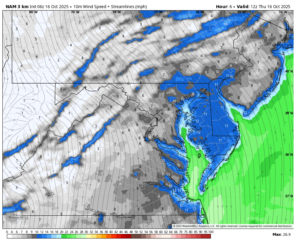
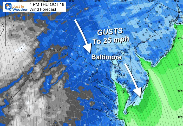
High Pressure is building in with a clear sky and gusty winds FROM the North. This will keep temps chilly.
The core of the cold air will settle in as the wind calms overnight and Friday morning.
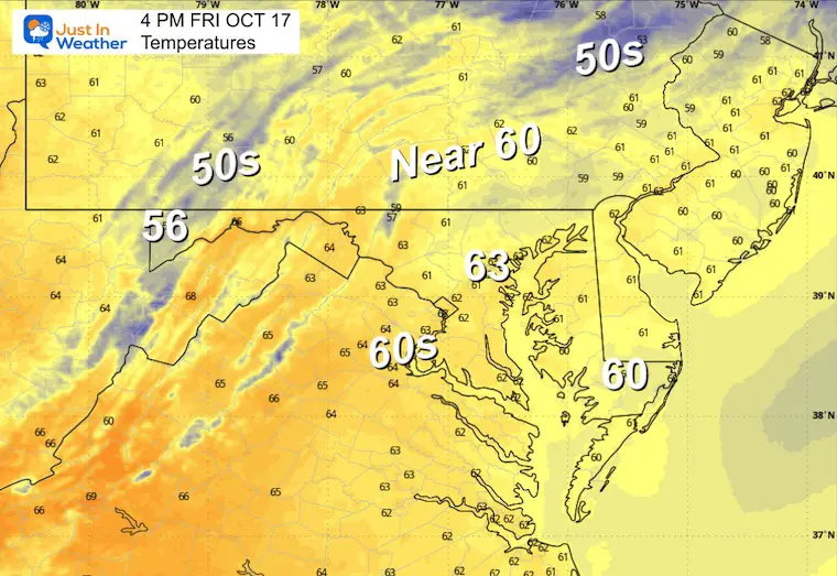
The next storm system is still a few days away. We will have a boost of warmer air ahead of it this weekend.
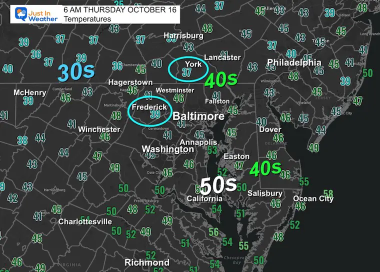
Morning Temperatures
Wind Animation: 8 AM to Midnight
Afternoon Winds
Strong Winds From The North
Afternoon Temperatures
CLIMATE DATA: Baltimore
Yesterday: Low 49F; High 73F
Precipitation: 0.00”
TODAY October 16
Sunrise at 7:18 AM
Sunset at 6:26 PM
Normal Low in Baltimore: 46ºF
Record 30ºF in 1876
Normal High in Baltimore: 68ºF
Record 90ºF 1897
Rainfall Deficit at BWI
- Ending 2024 = -8.00”
- Since Jan 1 = 5.47”
- We are STILL DOWN -13.47” INCLUDING LAST YEAR
Subscribe for eMail Alerts
FRIDAY
Morning Temperatures
Notice the area in the 30s. This may include Northern Baltimore and Harford Counties in Maryland, which is why I expect they may get added to the advisory.
Reminder Of Alerts
The Freeze Warning will be in the high mountain valleys where temperatures are likely to drop below 32°F.
Afternoon Temperatures
Looking Ahead:
Saturday Afternoon
A band of clouds will be passing to the north as an upper-level disturbance marks the wind shift. This may lead to more clouds for the northern half of our region.
That wind shift will allow a warm-up ahead of the next weather system.
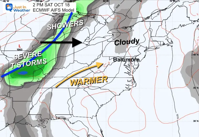
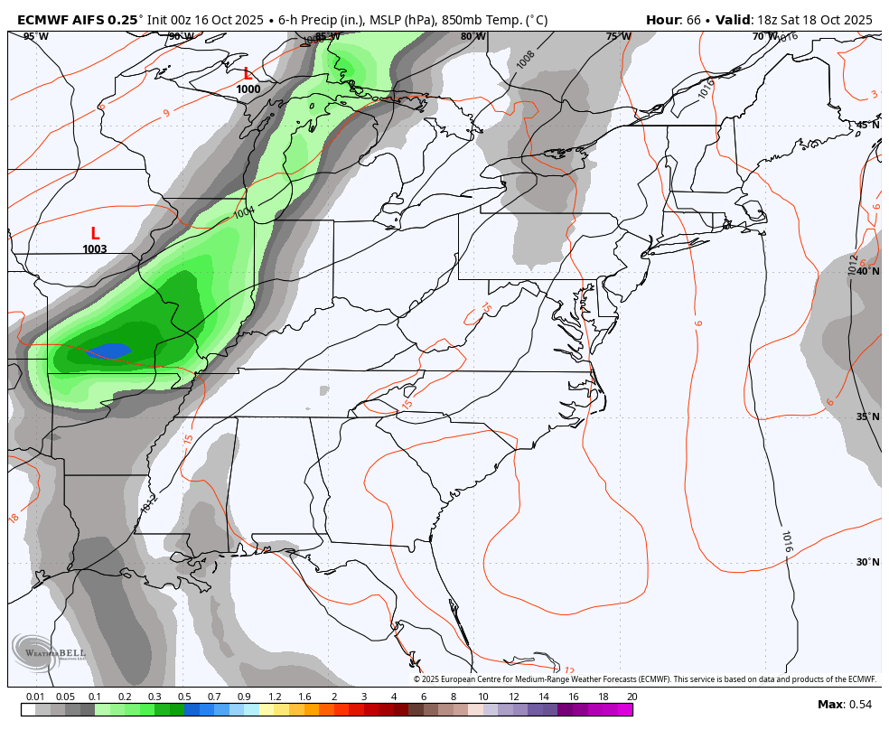
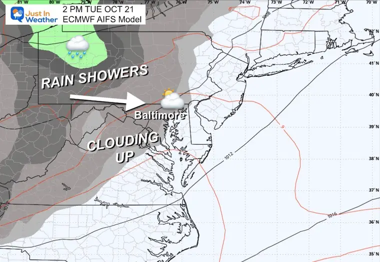
Storm Forecast: Saturday to Tuesday
Weekend warm-up will be the theme. Temps should get back to the 70s by Sunday, then a cold front will arrive.
At this time, the timeline looks to bring thunderstorms to the Ohio Valley and high mountains by Sunday afternoon. Then into metro areas Sunday night into Monday morning.
A pocket of cool air will follow, while a new Coastal Low Pressure may develop along the front and move up to New England.
Snapshots
Sunday Night
Monday Morning
Tuesday
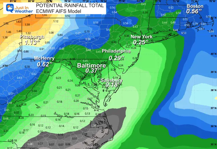
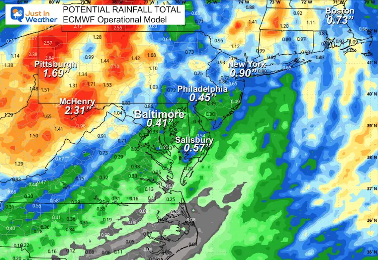
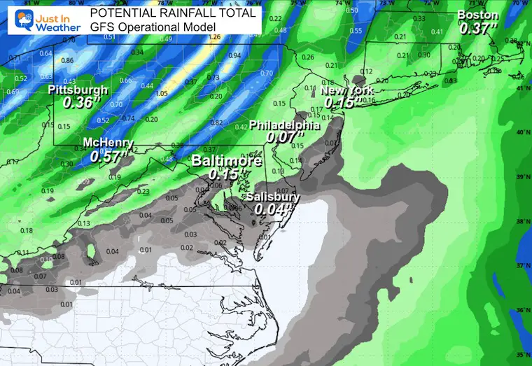
POTENTIAL RAINFALL
THIS IS A TEST: Let’s compare the AI Version of the European Model to the Operational version and the GFS Model.
Last week, I showed these three, and the AI version performed the best in this same time window. I will again do a comparison of the results.
ECMWF AIFS (AI Version)
ECMWF Operational Model (Traditional)
GFS Operational Mode (Traditional)
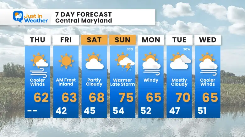
7 Day Forecast
- Today: Cool Winds
- Friday Morning: INLAND MORNING FROST
- Weekend: Warmer and Dry
- Sunday: Evening Rain/T’Storms
Subscribe for eMail Alerts
Average First Frost

La Niña Advisory
This was issued October 9, as expected: A weak and short-lived event to start winter may play a different role this winter

4 SUPERMOONS In A ROW

In Case You Missed It
Woolly Bear Caterpillar Winter Folklore
These are NOT all the same caterpillar!

Winter Outlook From 2 Farmers’ Almanacs

STEM Assemblies/In School Fields Trips Are Back
Click to see more and ‘Book’ a visit to your school

THANK YOU:
Baltimore Sun Magazine Readers’ Choice Best Of Baltimore

Maryland Trek 12 Day 7 Completed Sat August 9
UPDATED: We raised OVER $166,000 for Just In Power Kids – AND Still Collecting More
The annual event: Hiking and biking 329 miles in 7 days between The Summit of Wisp to Ocean City.
Each day, we honor a kid and their family’s cancer journey.
Fundraising is for Just In Power Kids: Funding Free Holistic Programs. I never have and never will take a penny. It is all for our nonprofit to operate.
Click here or the image to donate:

RESTATING MY MESSAGE ABOUT DYSLEXIA
I am aware there are some spelling and grammar typos and occasional other glitches. I take responsibility for my mistakes and even the computer glitches I may miss. I have made a few public statements over the years, but if you are new here, you may have missed it: I have dyslexia and found out during my second year at Cornell University. It didn’t stop me from getting my meteorology degree and being the first to get the AMS CBM in the Baltimore/Washington region. One of my professors told me that I had made it that far without knowing and to not let it be a crutch going forward. That was Mark Wysocki, and he was absolutely correct! I do miss my mistakes in my own proofreading. The autocorrect spell check on my computer sometimes does an injustice to make it worse. I can also make mistakes in forecasting. No one is perfect at predicting the future. All of the maps and information are accurate. The ‘wordy’ stuff can get sticky. There has been no editor who can check my work while writing and to have it ready to send out in a newsworthy timeline. Barbara Werner is a member of the web team that helps me maintain this site. She has taken it upon herself to edit typos when she is available. That could be AFTER you read this. I accept this and perhaps proves what you read is really from me… It’s part of my charm. #FITF
Please share your thoughts and best weather pics/videos, or just keep in touch via social media.


