Friday, September 19, 2025
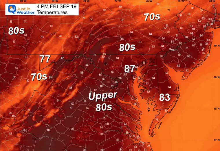
Today will feel like late summer as temps reach deep into the 80s. This will be after a start with fog on Maryland’s Lower Eastern Shore.
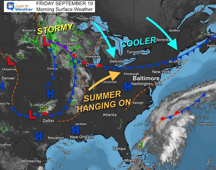
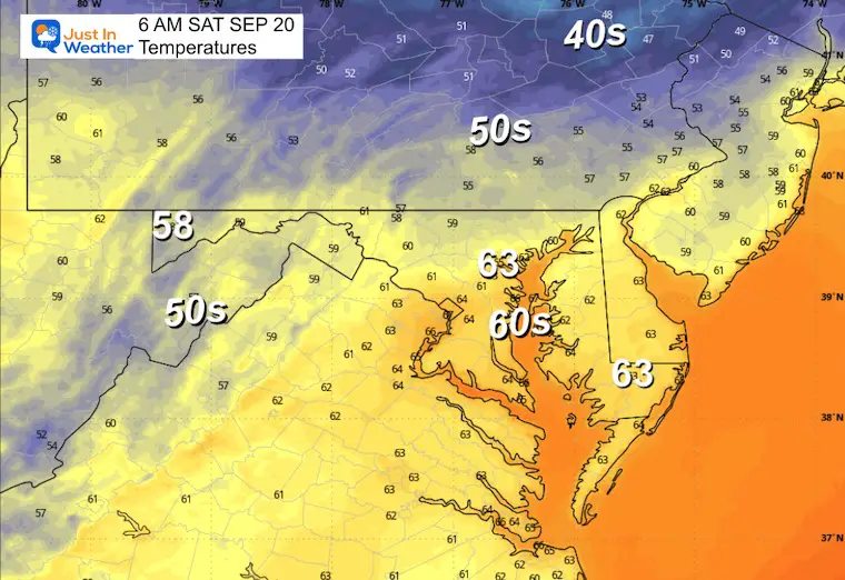
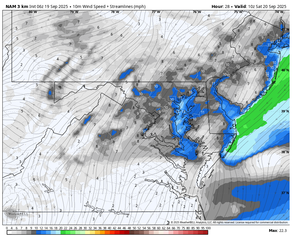
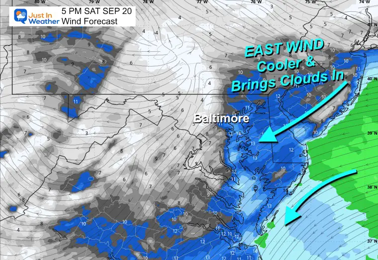
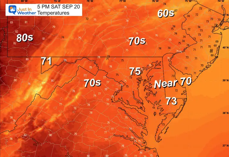
The next air mass with cooler air will arrive this weekend. Temps will drop into the 70s as winds shift to the East. This is worth watching because it may bring clouds and eventually showers for some areas, especially the mountains.
Next week brings the start of Autumn on Monday. The next cool air mass may bring rain and thunderstorms Tuesday night into Wednesday.
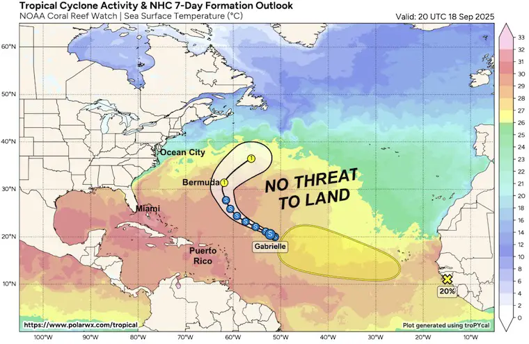
Tropical Storm Gabrielle is likely to remain East of Bermuda and not have an impact on the US coast.
WEATHER TODAY
Weather Warnings
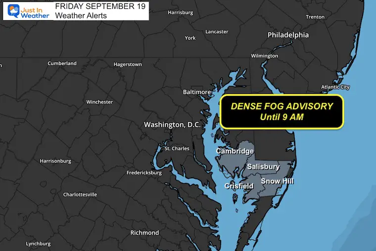
Dense Fog Advisory On The Lower Eastern Shore of Maryland.
This lasts until 9 AM.
Surface Weather
The coastal storm is moving away, but it has left behind moisture. Areas that received moderate inland rainfall have developed patches of fog. The fog is thick farther inland, where visibility is under 1 mile. The fog will lift and allow for sunshine as a Northwest wind will develop.
A brief warm period will follow through tomorrow.
Afternoon Temperatures
CLIMATE DATA: Baltimore
Yesterday: Low 64F; High 84F
Precipitation: 0.01”
TODAY September 19
Sunrise at 6:52 AM
Sunset at 7:08 PM
Normal Low in Baltimore: 58ºF
Record 42ºF in 1959
Normal High in Baltimore: 79ºF
Record 94ºF 1896; 1983; 1959
Rainfall Deficit at BWI
- Ending 2024 = -8.00”
- Since Jan 1 = 2.70”
- We are STILL DOWN -10.70” INCLUDING LAST YEAR
Subscribe for eMail Alerts
SATUDAY
Morning Temperatures
Wind Forecast 6 AM to 8 PM
Afternoon Snapshot
This wind FROM THE EAST will bring in cooler air and increase close to the coast. This will push inland for Sunday.
Afternoon Temperatures
LOOKING AHEAD
Sunday Morning
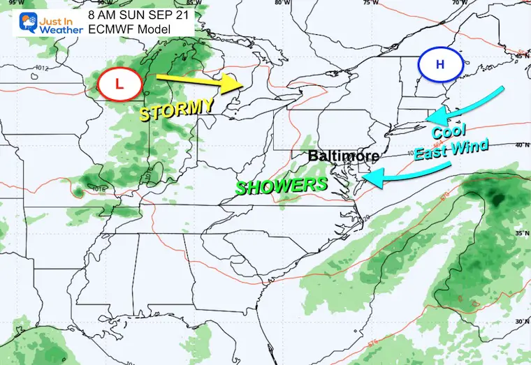
With High Pressure slipping off the New England Coast, this will push an Easterly Wind (onshore) on Sunday, which may develop more clouds and showers.
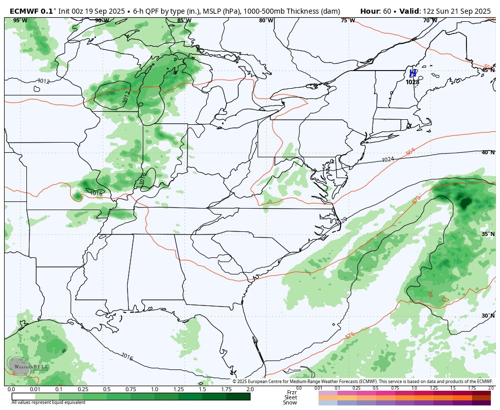
Storm Forecast Sunday to Thursday
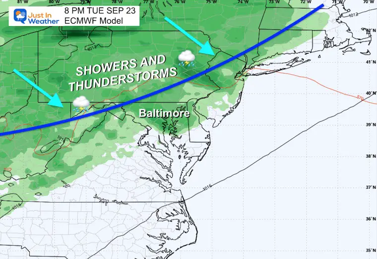
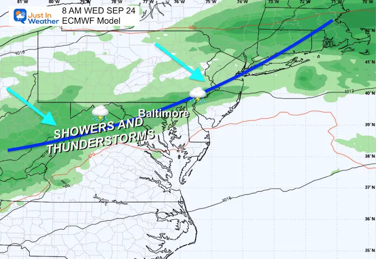
The next weather system will bring showers and thunderstorms from the Great Lakes to reach our region late Tuesday into Wednesday. This will be followed by the next round of cooler air.
Tuesday Evening
Wednesday Morning
Tropical Outlook: Atlantic
Tropical Storm Gabrielle has formed. Winds are still 50 mph, and it looks to be turning East of Bermuda.
The next system will likely stay out in the ocean IF it develops.
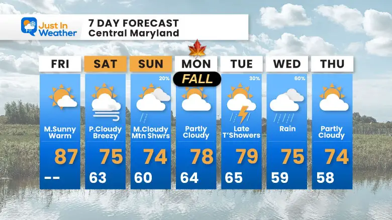
7 Day Forecast
- Warm Two Days
- Weekend Slightly Cooler
- Warmer Next Week
Subscribe for eMail Alerts
STEM Assemblies/In School Fields Trips Are Back
Click to see more and ‘Book’ a visit to your school

THANK YOU:
Baltimore Sun Magazine Readers’ Choice Best Of Baltimore

Maryland Trek 12 Day 7 Completed Sat August 9
UPDATED: We raised OVER $166,000 for Just In Power Kids – AND Still Collecting More
The annual event: Hiking and biking 329 miles in 7 days between The Summit of Wisp to Ocean City.
Each day, we honor a kid and their family’s cancer journey.
Fundraising is for Just In Power Kids: Funding Free Holistic Programs. I never have and never will take a penny. It is all for our nonprofit to operate.
Click here or the image to donate:

RESTATING MY MESSAGE ABOUT DYSLEXIA
I am aware there are some spelling and grammar typos and occasional other glitches. I take responsibility for my mistakes and even the computer glitches I may miss. I have made a few public statements over the years, but if you are new here, you may have missed it: I have dyslexia and found out during my second year at Cornell University. It didn’t stop me from getting my meteorology degree and being the first to get the AMS CBM in the Baltimore/Washington region. One of my professors told me that I had made it that far without knowing and to not let it be a crutch going forward. That was Mark Wysocki, and he was absolutely correct! I do miss my mistakes in my own proofreading. The autocorrect spell check on my computer sometimes does an injustice to make it worse. I can also make mistakes in forecasting. No one is perfect at predicting the future. All of the maps and information are accurate. The ‘wordy’ stuff can get sticky. There has been no editor who can check my work while writing and to have it ready to send out in a newsworthy timeline. Barbara Werner is a member of the web team that helps me maintain this site. She has taken it upon herself to edit typos when she is available. That could be AFTER you read this. I accept this and perhaps proves what you read is really from me… It’s part of my charm. #FITF
Please share your thoughts and best weather pics/videos, or just keep in touch via social media.


