August 18, 2025
2:20 PM Monday
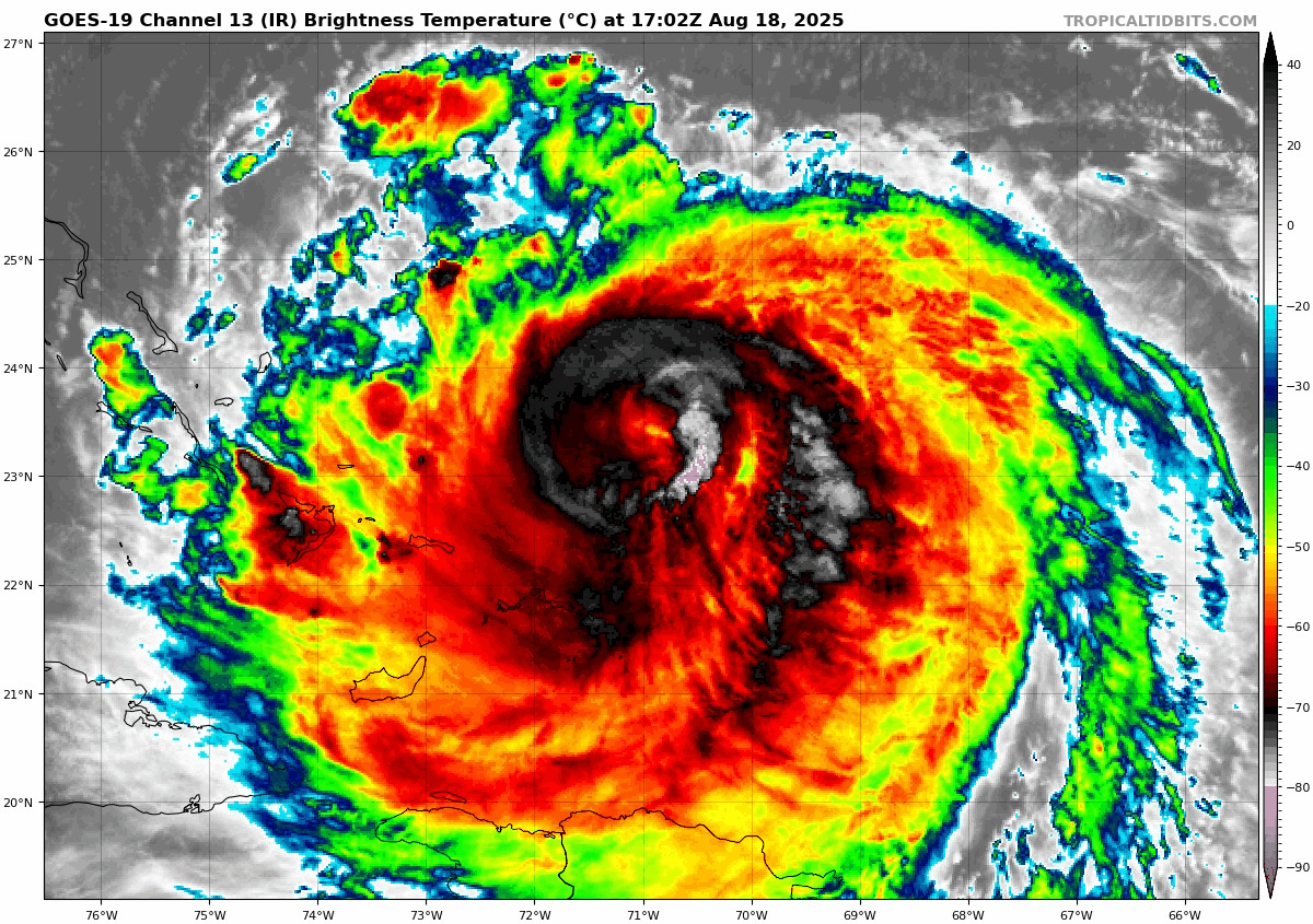
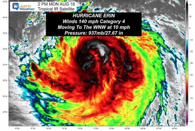
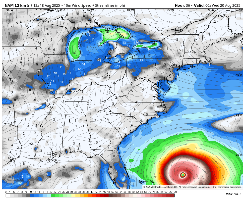
Hurricane Erin has maintained Category 4 intensity today. Winds were 140 mph in the 2 PM Update from the National Hurricane Center. The footprint has more than doubled in size since the weekend and is expected to grow larger as it heads north. Hurricane Force Winds reach 80 miles from the center, Tropical Storm Force Winds extend 230 miles from the center. By Thursday, the width of the wind field could double again.
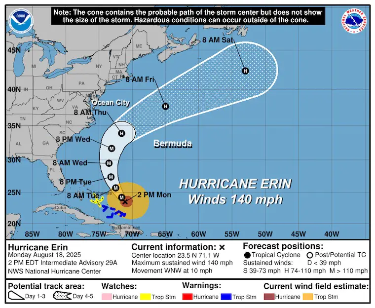
The slight adjustment to the track and this size will bring tropical storm winds to the North Carolina coast, prompting the evacuations from the Outer Banks today.
The eye will remain a few hundred miles off the coast, so it will not make landfall. But the impact will work on already high water and pound Mid-Atlantic beaches with growing waves and beach erosion all week, with the worst conditions on Thursday.
In this report, we will examine Hurricane Erin’s impact on North Carolina and the rest of the Mid-Atlantic.
Tropical Outlook
Hurricane Erin Satellite Loop
Update From The National Hurricane Center
2 PM Monday Aug 18
- LOCATION…23.5N 71.1W
- ABOUT 140 MI…220 KM N OF GRAND TURK ISLAND
- ABOUT 850 MI…1370 KM SSE OF CAPE HATTERAS NORTH CAROLINA
- MAXIMUM SUSTAINED WINDS…140 MPH…220 KM/H
- PRESENT MOVEMENT…WNW OR 300 DEGREES AT 10 MPH…17 KM/H
- MINIMUM CENTRAL PRESSURE…937 MB…27.67 INCHES
SUMMARY OF WATCHES AND WARNINGS IN EFFECT:
A Tropical Storm Warning is in effect for…
* Turks and Caicos Islands
* Southeast Bahamas
A Tropical Storm Watch is in effect for…
* Central Bahamas
Forecast Intensity
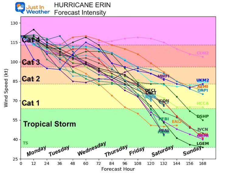
NHC Forecast Outlook…
Still expected to pass NORTH of the Caribbean Islands, East of the Bahamas, AND West of Bermuda.
NHC Forecast Winds (Over Tropical Storm Intensity)
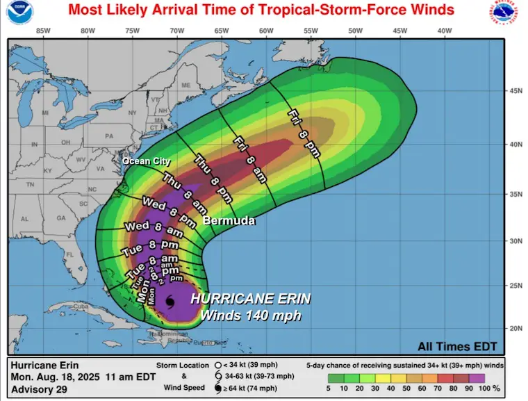
North Carolina Expectations
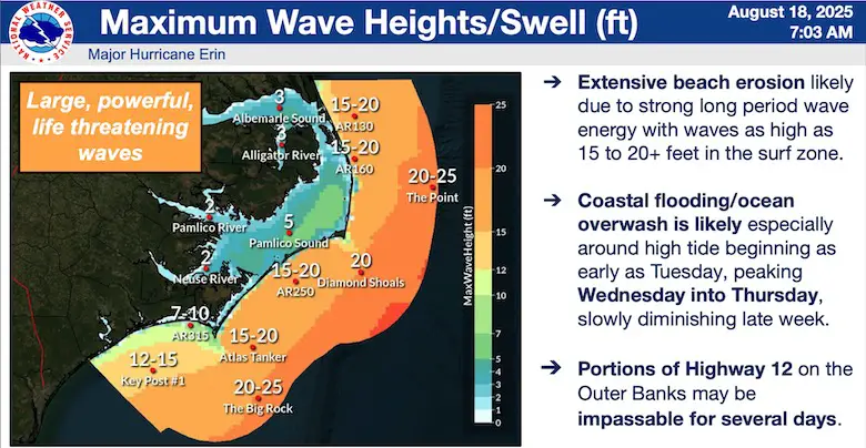
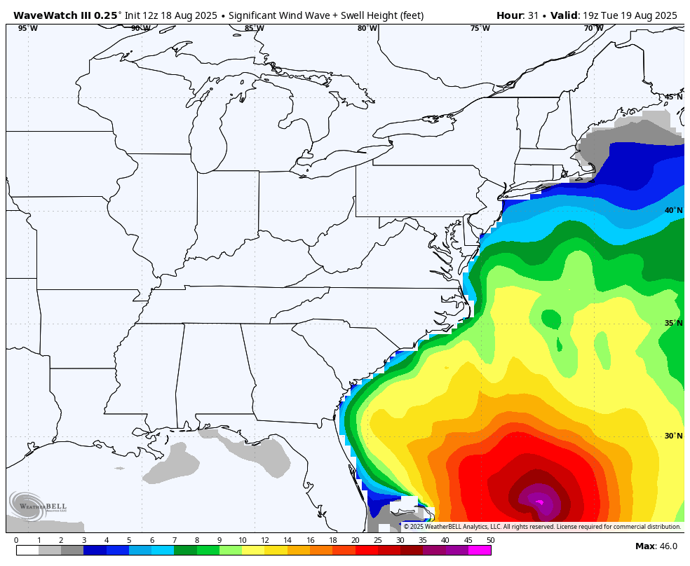
NOAA Wave Heights
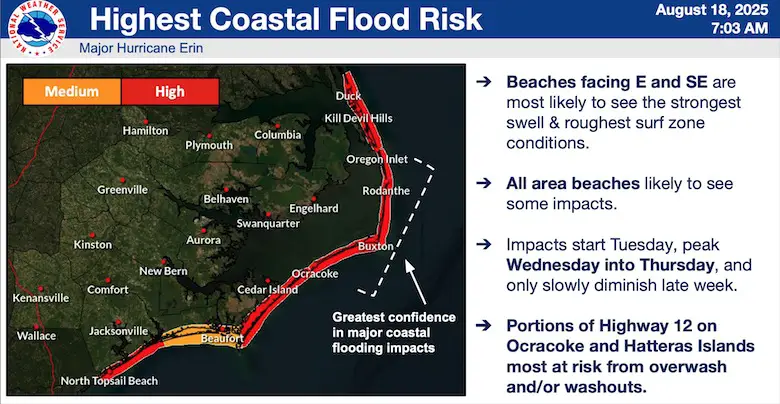
NOAA Coastal Flooding
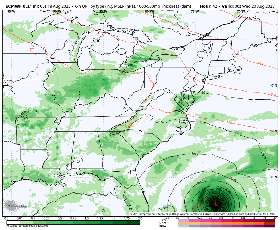
European Model Forecast Simulation
Tuesday Evening to Friday Morning
A cold front will approach the Eastern US, which will help steer Erin farther out to sea.
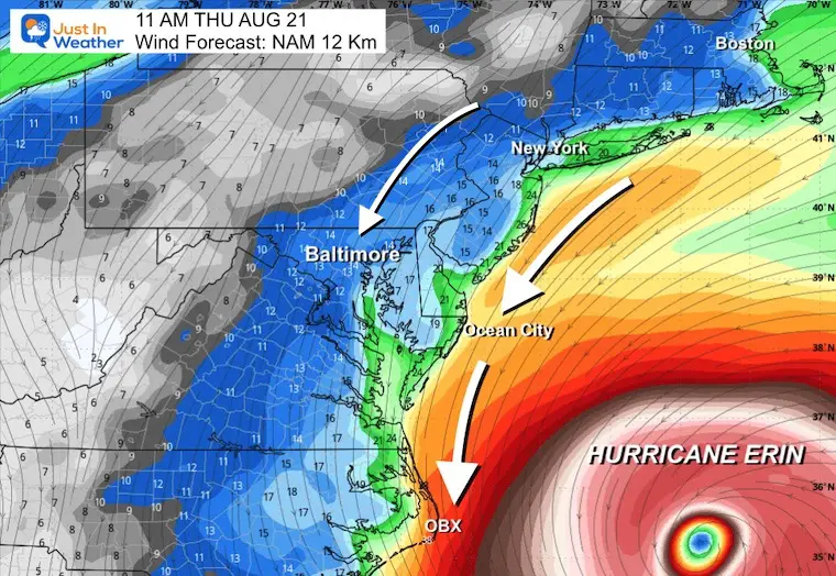
Wind Forecast:
Tuesday Evening to Thursday Evening NAM 12 Km
Snapshots
Thursday Morning Wind Speed and Direction
Hurricane Erin will be two hundred miles offshore. This will spin winds counterclockwise FROM the Northeast.
Average winds will be 15 to 25 mph. Gusts will be higher!
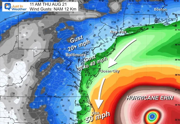
Wind Gusts
Gusts over 50 mph on the North Carolina Outer Banks.
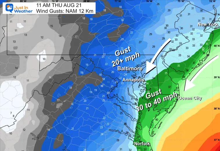
20 to 40 mph across Maryland and Delaware
Local Look
Lower Delmarva will experience gusts up to 40 mph, on the threshold of tropical storm intensity. The direction will be FROM the Northeast. This will also slosh the water higher on the West Side of the Chesapeake Bay.
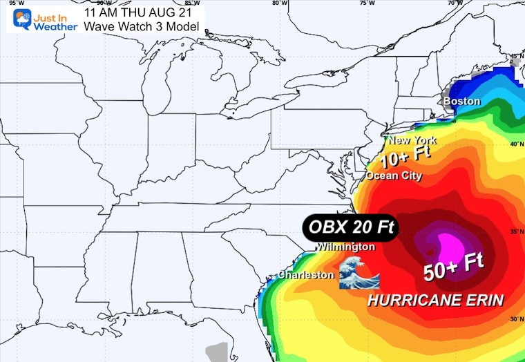
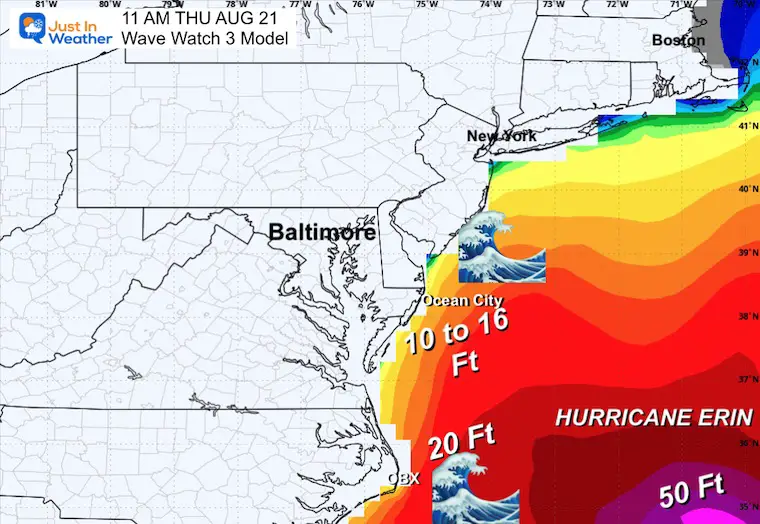
Wave Watch 3 Model
Tuesday Afternoon to Friday Afternoon
Here we can see the high water influence approaching the East Coast.
Yes, there will be rip currents and high water up the Chesapeake Bay… but the worst will stay out to sea.
Snapshot Thursday Morning
Peak Waves may reach 10′ to 16′. This may be good news for surfers, but coastal beach erosion is also expected.
Near the center of Erin waves will likely be 50 feet or higher. This is to be expected with a Major Hurricane.
Closer Look
Considering we have high waves already these areas, it will be a long week as they grow stronger.
Interactive Wind Widget
Subscribe for eMail Alerts
Please share your thoughts and best weather pics/videos, or just keep in touch via social media.
THANK YOU:
Baltimore Sun Magazine Readers Choice Best Of Baltimore
RESTATING MY MESSAGE ABOUT DYSLEXIA
I am aware there are some spelling and grammar typos and occasional other glitches. I take responsibility for my mistakes and even the computer glitches I may miss. I have made a few public statements over the years, but if you are new here, you may have missed it: I have dyslexia and found out during my second year at Cornell University. It didn’t stop me from getting my meteorology degree and being the first to get the AMS CBM in the Baltimore/Washington region. One of my professors told me that I had made it that far without knowing and to not let it be a crutch going forward. That was Mark Wysocki, and he was absolutely correct! I do miss my mistakes in my own proofreading. The autocorrect spell check on my computer sometimes does an injustice to make it worse. I also can make mistakes in forecasting. No one is perfect at predicting the future. All of the maps and information are accurate. The ‘wordy’ stuff can get sticky. There has been no editor who can check my work while writing and to have it ready to send out in a newsworthy timeline. Barbara Werner is a member of the web team that helps me maintain this site. She has taken it upon herself to edit typos when she is available. That could be AFTER you read this. I accept this and perhaps proves what you read is really from me… It’s part of my charm. #FITF
Maryland Trek 12 Day 7 Completed Sat August 9
UPDATED: We raised OVER $161,000 for Just In Power Kids – AND Still Collecting More
The annual event: Hiking and biking 329 miles in 7 days between The Summit of Wisp to Ocean City.
Each day, we honor a kid and their family’s cancer journey.
Fundraising is for Just In Power Kids: Funding Free Holistic Programs. I never have and never will take a penny. It is all for our nonprofit to operate.
Click here or the image to donate:


