Saturday, August 16 2025
Morning Report
Our local weather is still warm and sticky with some late-day thundershowers expected. We will get to that below, but the tropics take the lead headline today.
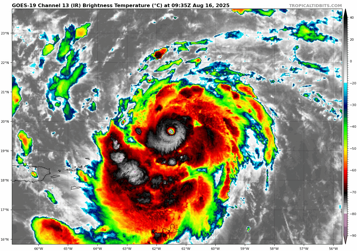
Hurricane Erin has strengthened even more rapidly than expected overnight. As of this 6 AM morning, NOAA Hurricane Hunters found sustained winds at 130 mph, making this a Category 4 storm. Updated at 8 AM with winds to 145 mph!
This will become very large, and while it will miss a direct landfall, it will affect the entire East Coast with large waves.
Tropical Outlook
Hurricane Erin Satellite
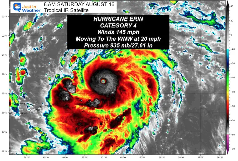
EDIT 8 AM NHC UPDATE
Winds 145 mph: This is RAPIDLY INTENSIFYING
Hurricane Force Winds reach 30 miles from the center; Tropical Storm Force Winds extend 125 miles from the center.
Update From The National Hurricane Center
UPDATED 8 AM Saturday Morning
- LOCATION…19.6N 62.0W
- ABOUT 120 MI…195 KM NE OF ANGUILLA
- MAXIMUM SUSTAINED WINDS…145 MPH…230 KM/H
- PRESENT MOVEMENT…WNW OR 285 DEGREES AT 20 MPH…31 KM/H
- MINIMUM CENTRAL PRESSURE…935 MB…27.61 INCHES
SUMMARY OF WATCHES AND WARNINGS IN EFFECT:
A Tropical Storm Watch is in effect for…
- St. Martin and St. Barthelemy
- Sint Maarten
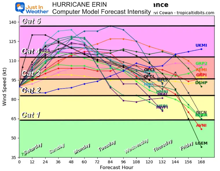
Forecast Intensity
Now at Major Hurricane Ranking, it is expected to remain as such while passing over very warm water. It will gradually weaken as it pushes farther north into colder water.
NHC Forecast Outlook…
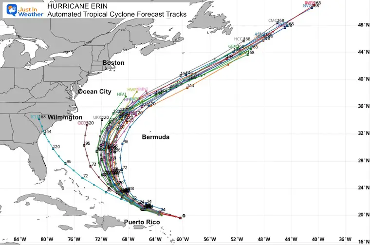
Still expected to pass NORTH of the Caribbean Islands, East of the Bahamas, AND West of Bermuda.
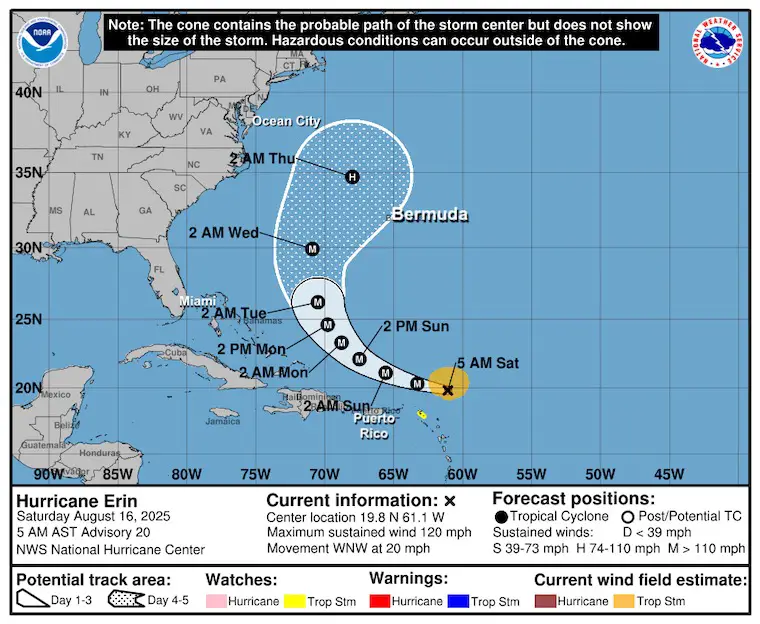
Automated Tropical Cyclone Forecast Tracks
This expected track BETWEEN the US and Bermuda is holding up consistently.
FORECAST IMPACT ON THE EAST COAST BELOW
Local Weather Today
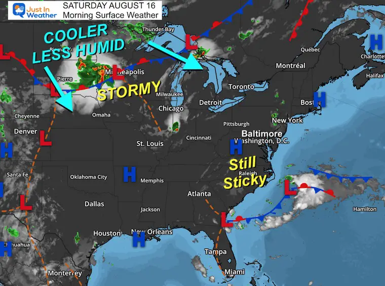
Surface Weather
High Pressure remains in control. There may be a hint of lower humidity later today, but not this morning…. It is a bit sticky.
The next impactful weather feature will be the Cold Front in the Northern Plains, which will arrive in the middle of the work week. That will bring us more thunderstorms, a cooler air mass, and help steer Erin off the coast.
Live Radar Widget
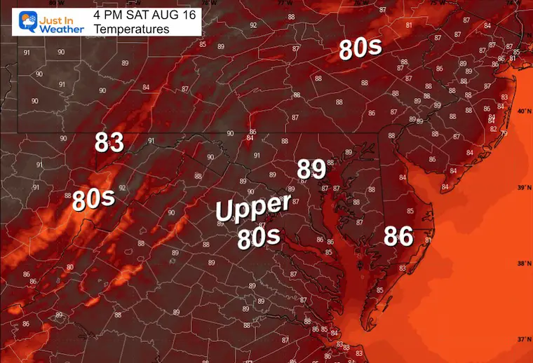
Afternoon Temperatures
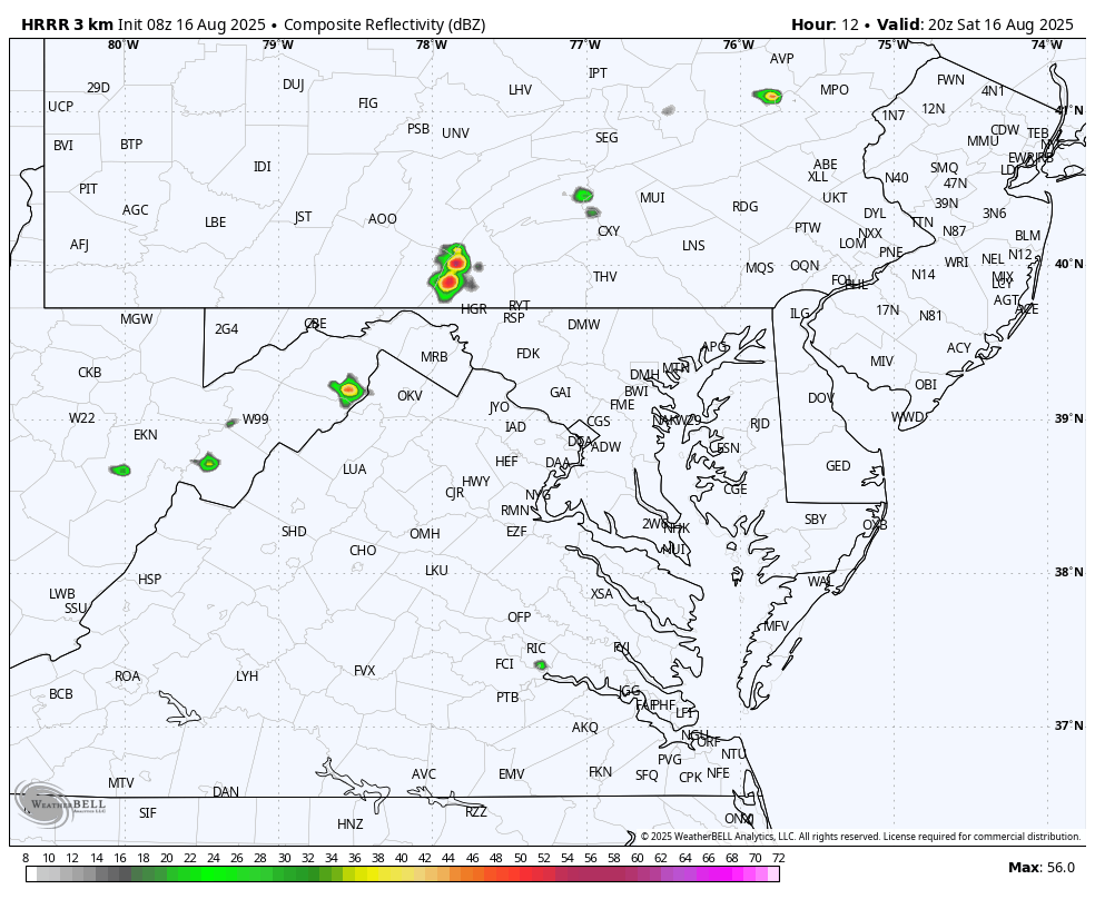
Radar Simulation: 4 PM to Midnight
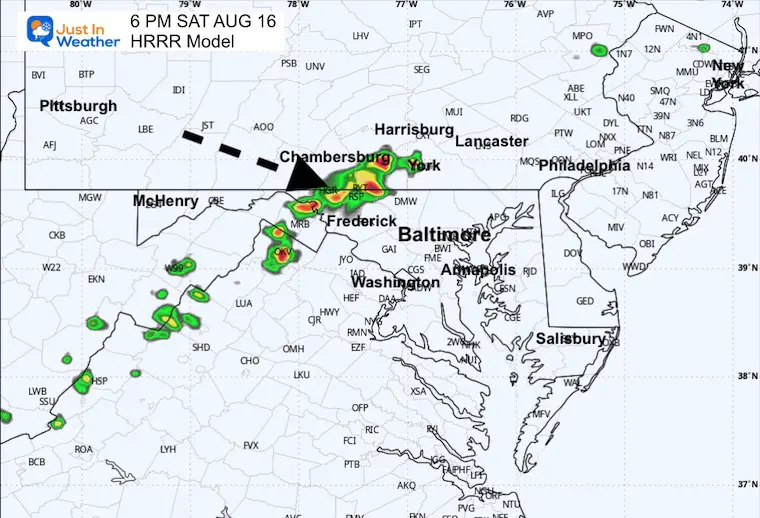
Scattered thundershowers will form with the East wind. They will be scattered and move towards the West/Northwest.
Snapshot at 6 PM
CLIMATE DATA: Baltimore
Yesterday: Low 72F; High 91F
TODAY August 16
The last day of the year with sunset at 8 PM
Sunrise at 6:21 AM
Sunset at 8:00 PM
Normal Low in Baltimore: 66ºF
Record 53ºF in 2013
Normal High in Baltimore: 87ºF
Record 101ºF 1997
Rainfall Deficit at BWI
- Ending 2024 = -8.00”
- Since Jan 1 = 0.75”
- We are STILL DOWN -8.75” INCLUDING LAST YEAR
Subscribe for eMail Alerts
Maryland Trek 12 Day 7 Completed Sat August 9
UPDATED: We raised OVER $161,000 for Just In Power Kids – AND Still Collecting More
The annual event: Hiking and biking 329 miles in 7 days between The Summit of Wisp to Ocean City.
Each day, we honor a kid and their family’s cancer journey.
Fundraising is for Just In Power Kids: Funding Free Holistic Programs. I never have and never will take a penny. It is all for our nonprofit to operate.
Click here or the image to donate:

SUNDAY
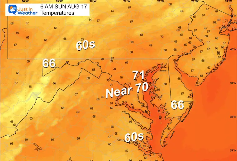
Morning Temperatures
Afternoon Temperatures

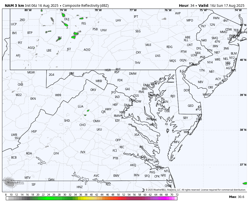
Radar Simulation Noon to Midnight
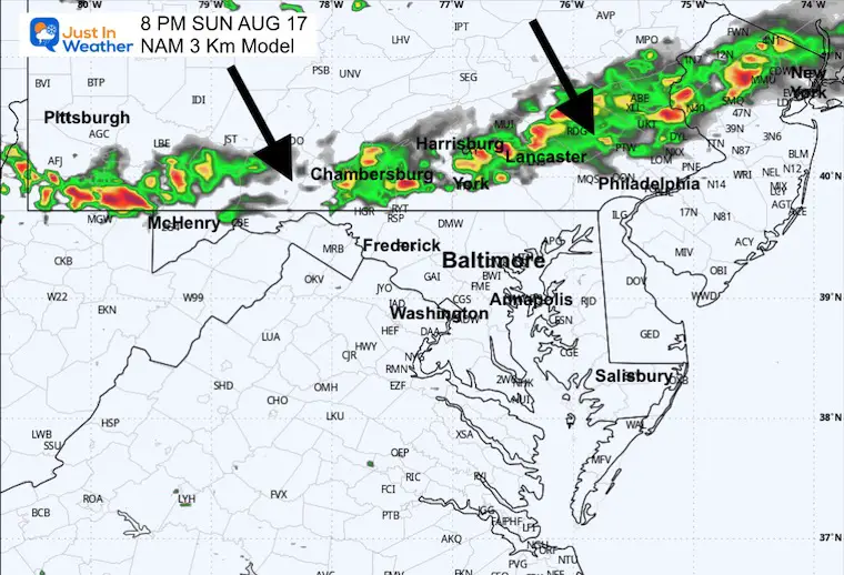
Snapshot 8 PM
A line of thunderstorms will drop southward from Pennsylvania in the evening.
ECMWF Model Animation:
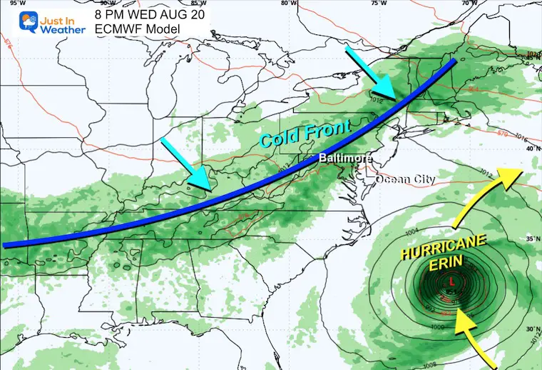
Tuesday Aug 19 to Friday Aug 22
The typical curve is expected to pass well between the US and Bermuda.
The rain bands will affect the Northeast Caribbean Islands and maybe the Outer Banks (OBX) of North Carolina. A cold front approaching from the Ohio Valley and Great Lakes will bring rain to the Mid Atlantic and keep Erin well offshore.
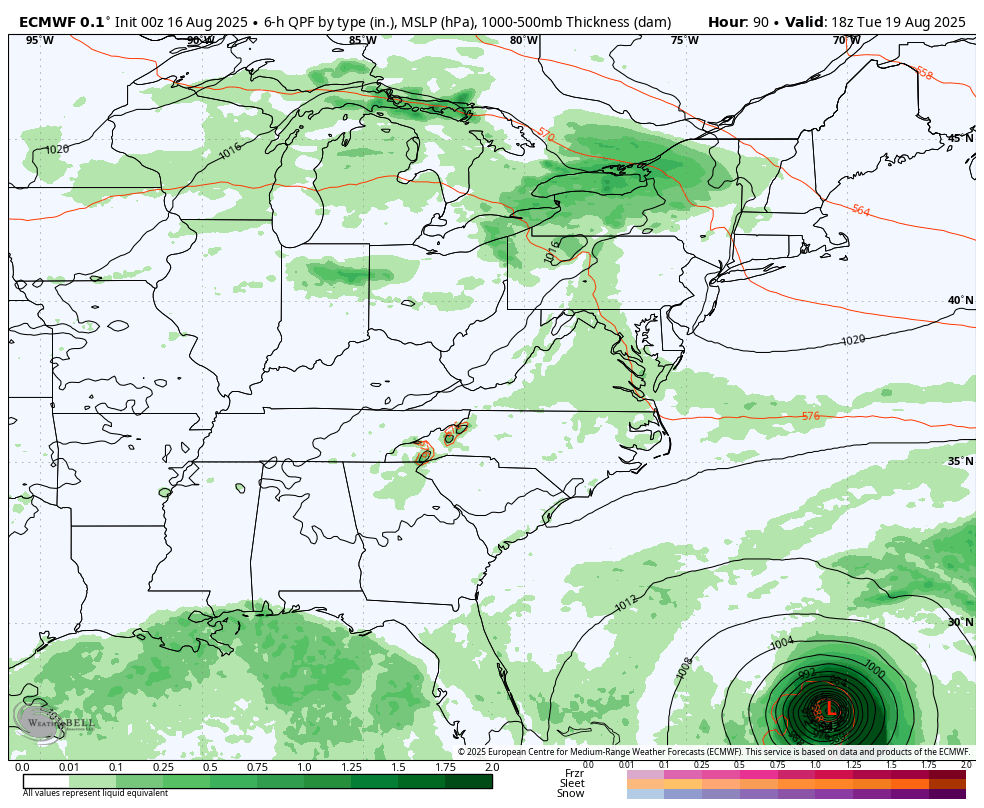
Snapshot Wednesday, August 20
A cold front heading across the Ohio Valley is expected to help keep Erin off the coast. WE will have more thunderstorms, NOT part of the Hurricane!
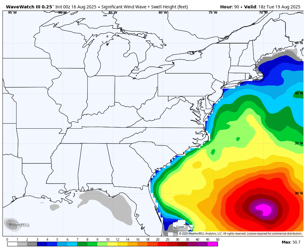
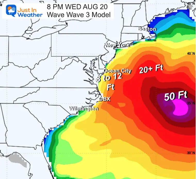
Wave Forecast East Coast
Tuesday To Friday
Waves 8 to 12 Feet across the Mid-Atlantic Coast.
Over 50 Foot waves near the storm’s center, well off the coast.
Snapshot Wednesday
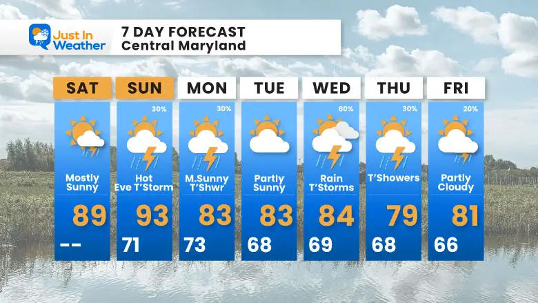
7 Day Forecast
- Weekend: Sunny, Less Humid
- Next Week: Storms Wednesday Push Erin Offshore
- Cooler Temps Will Follow
Subscribe for eMail Alerts
Please share your thoughts and best weather pics/videos, or just keep in touch via social media.
THANK YOU:
Baltimore Sun Magazine Readers Choice Best Of Baltimore
RESTATING MY MESSAGE ABOUT DYSLEXIA
I am aware there are some spelling and grammar typos and occasional other glitches. I take responsibility for my mistakes and even the computer glitches I may miss. I have made a few public statements over the years, but if you are new here, you may have missed it: I have dyslexia and found out during my second year at Cornell University. It didn’t stop me from getting my meteorology degree and being the first to get the AMS CBM in the Baltimore/Washington region. One of my professors told me that I had made it that far without knowing and to not let it be a crutch going forward. That was Mark Wysocki, and he was absolutely correct! I do miss my mistakes in my own proofreading. The autocorrect spell check on my computer sometimes does an injustice to make it worse. I also can make mistakes in forecasting. No one is perfect at predicting the future. All of the maps and information are accurate. The ‘wordy’ stuff can get sticky. There has been no editor who can check my work while writing and to have it ready to send out in a newsworthy timeline. Barbara Werner is a member of the web team that helps me maintain this site. She has taken it upon herself to edit typos when she is available. That could be AFTER you read this. I accept this and perhaps proves what you read is really from me… It’s part of my charm. #FITF


