Sunday, July 27 2025
Morning Report
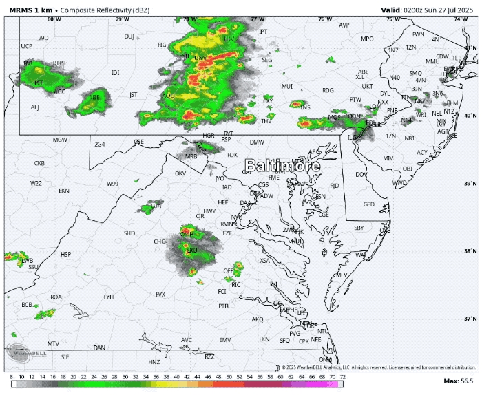
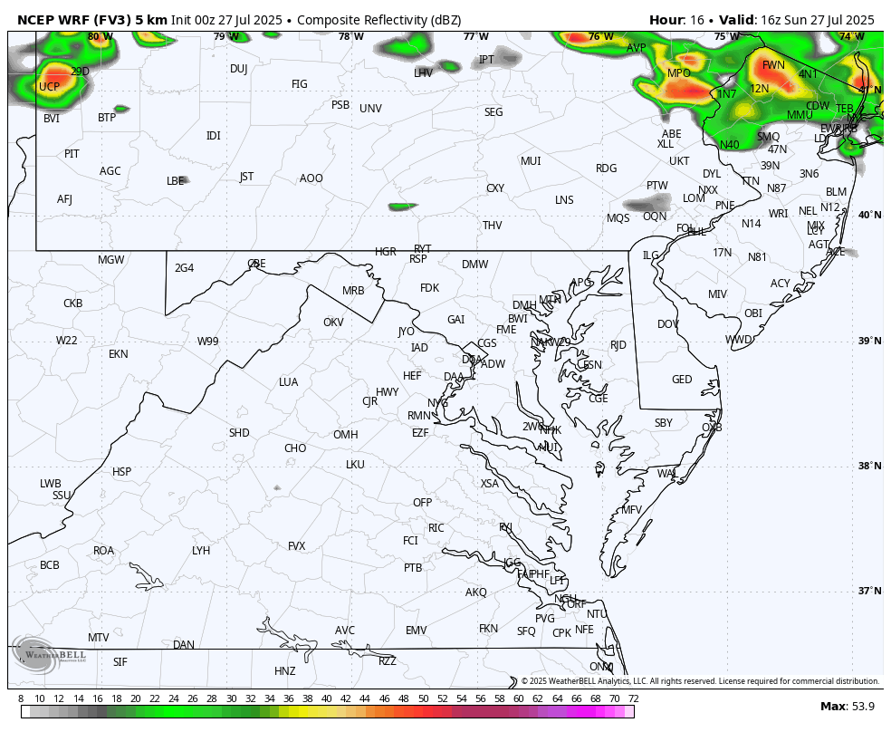
Did storms with vivid lightning and loud booms wake you up overnight? A series of strong thunderstorms moved through, and I have a radar recap below.
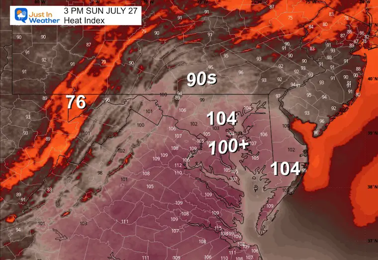
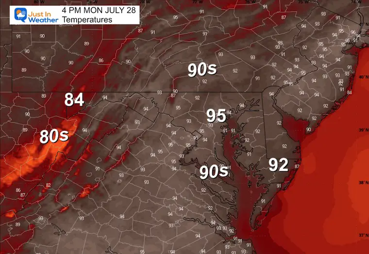
This was along a frontal boundary that will bring back the Heat Dome for a few days. It may include heavy rain producing storms this afternoon AND heat index values back into the 100s early in the work week.
A pattern change is in sight. Strong thunderstorms on Thursday will be followed by a new air mass that will set up shop for a while! This may bring us up to 10 degrees below average temperatures that last into the first part of August…
In Case You Missed This
Ocean City Lightning
Recap: Saturday Night Thunderstorms
Lightning Counter
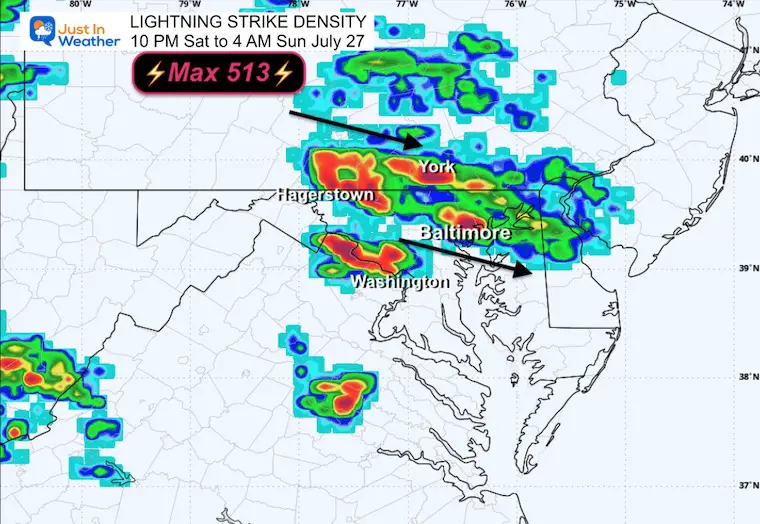
Radar Recap: 10 PM Saturday to 4 AM Sunday
Weather Today: Sunday
Live Radar and Lightning
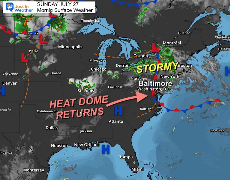
Surface Weather
The overnight storms were in response to this frontal boundary leading the edge of the Heat Dome.
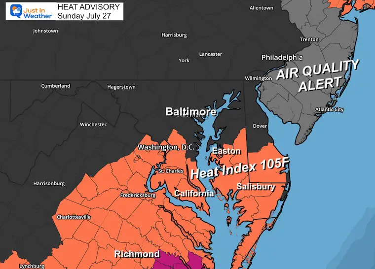
Heat Advisory
The extreme heat will return to Southern Maryland first.
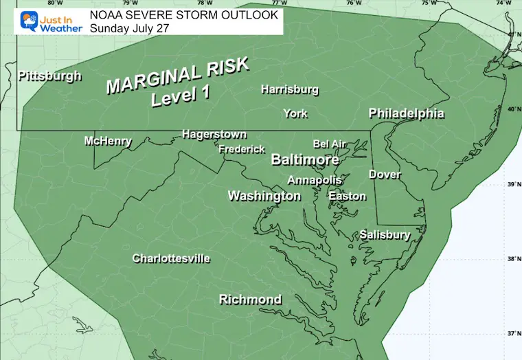
NOAA Severe Storm Outlook
We are in the Marginal Risk for storms to turn severe.
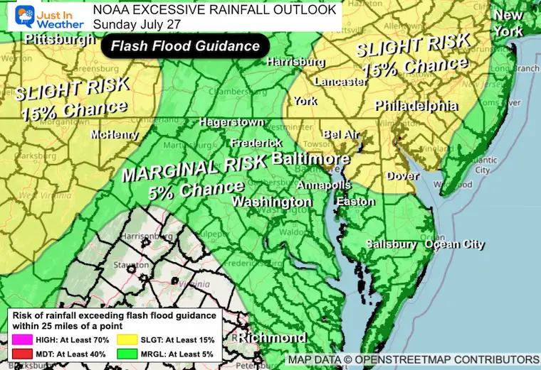
Excessive Rainfall Outlook
Flash Flood Guidance.
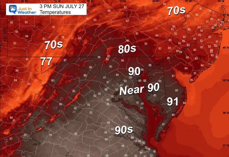
Forecast Today
Afternoon Temperatures
Heat Index
Radar Simulation: Noon to Midnight
Suggestion: Not A Promise
Most Active Time: 2 PM to 8 PM
CLIMATE DATA: Baltimore
Yesterday: Low 74F; High 90F
Rainfall = 0.00”
TODAY July 27
Sunrise at 6:03 AM
Sunset at 8:23 PM
Normal Low in Baltimore: 68ºF
Record 52ºF in 1962
Normal High in Baltimore: 88ºF
Record 101ºF 1940
Rainfall Deficit at BWI
Ending 2024 = -8.00”
Since Jan 1 = -0.69”
We are STILL DOWN -8.69” INCLUDING LAST YEAR
Subscribe for eMail Alerts
Note: Maryland Trek 12
Our team will begin one week from today, Sunday, August 3, on our week-long, 329-mile hike and bike across the state to honor kids and families in Just In Power Kids acing Childhood Cancer.
Click to see more


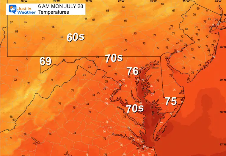
MONDAY
Morning Temperatures
Afternoon Temperatures
Looking Ahead This Week:
Hot Start Then Pattern Change Next Weekend
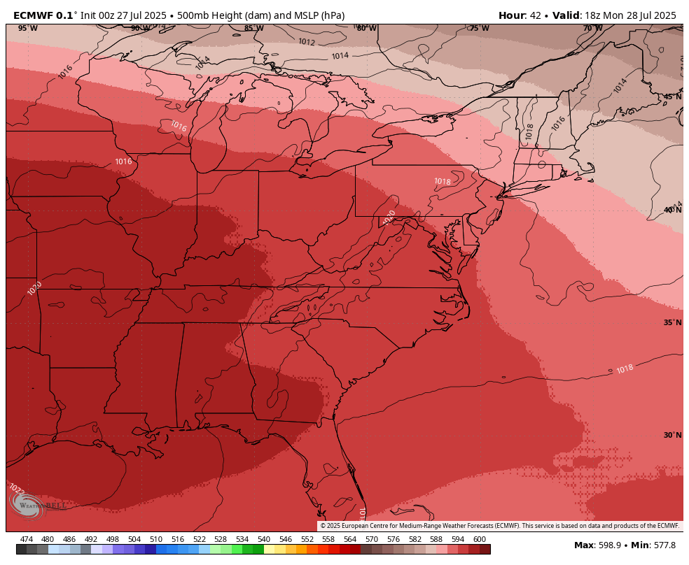
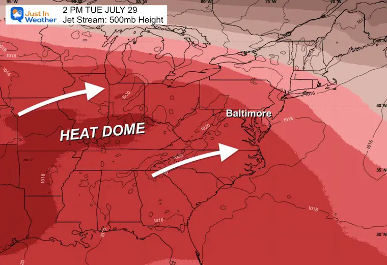
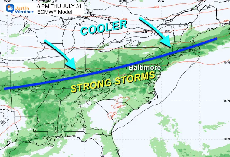
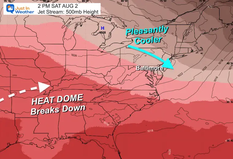
Jet Stream 500mb Heights: Monday to Saturday
Heat Dome EXPANDS our way, then breaks with a strong cold front on Thursday.
Snapshot Tuesday
Snapshot Surface Weather Thursday
Snapshot Saturday
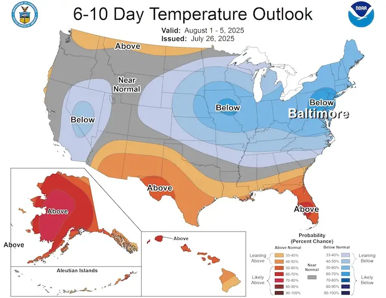
NOAA Temperature Outlook
Shift of cooler air arriving next weekend and into the start of August.
This should bring temperatures 5 to 10 degrees cooler than average.
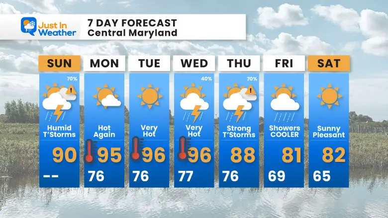
7 Day Forecast
- Extreme Heat For A Few Days
- Thursday: Strong Storms
- Friday: Pattern Change
Subscribe for eMail Alerts
Please share your thoughts and best weather pics/videos, or just keep in touch via social media.
THANK YOU:
Baltimore Sun Magazine Readers Choice Best Of Baltimore
Maryland Trek 11 Day 7 Completed Sat August 10
We raised OVER $111,000 for Just In Power Kids – AND Still Collecting More
The annual event: Hiking and biking 329 miles in 7 days between The Summit of Wisp to Ocean City.
Each day, we honor a kid and their family’s cancer journey.
Fundraising is for Just In Power Kids: Funding Free Holistic Programs. I never have and never will take a penny. It is all for our nonprofit to operate.
Click here or the image to donate:

RESTATING MY MESSAGE ABOUT DYSLEXIA
I am aware there are some spelling and grammar typos and occasional other glitches. I take responsibility for my mistakes and even the computer glitches I may miss. I have made a few public statements over the years, but if you are new here, you may have missed it: I have dyslexia and found out during my second year at Cornell University. It didn’t stop me from getting my meteorology degree and being the first to get the AMS CBM in the Baltimore/Washington region. One of my professors told me that I had made it that far without knowing and to not let it be a crutch going forward. That was Mark Wysocki, and he was absolutely correct! I do miss my mistakes in my own proofreading. The autocorrect spell check on my computer sometimes does an injustice to make it worse. I also can make mistakes in forecasting. No one is perfect at predicting the future. All of the maps and information are accurate. The ‘wordy’ stuff can get sticky. There has been no editor who can check my work while writing and to have it ready to send out in a newsworthy timeline. Barbara Werner is a member of the web team that helps me maintain this site. She has taken it upon herself to edit typos when she is available. That could be AFTER you read this. I accept this and perhaps proves what you read is really from me… It’s part of my charm. #FITF


