Wednesday, July 9 2025
Morning Report
This may look a lot like the weather report from yesterday, and a lot may be similar, but it is brand new for Wednesday. Just atmospheric memory recycling itself. High humidity with dew points in the mid 70s will provide the ample moisture for any thunderstorm to produce rainfall rates of 2 inches per hour. That is why we have the potential for flooding.
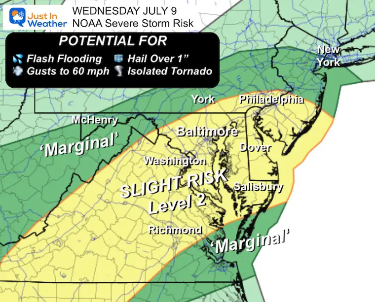
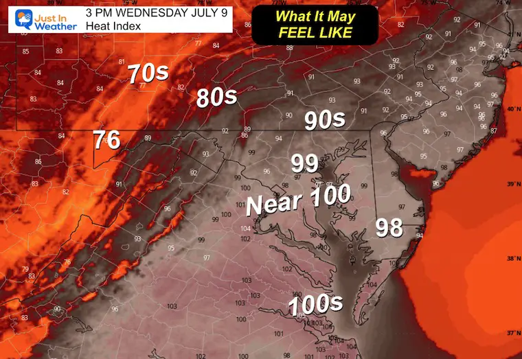
Yesterday reached the mid- to upper 90s, and while today will not be as hot, the heat index will make it feel close to 100℉. This will fuel storms to turn severe, and NOAA does have us in the risk zone again.
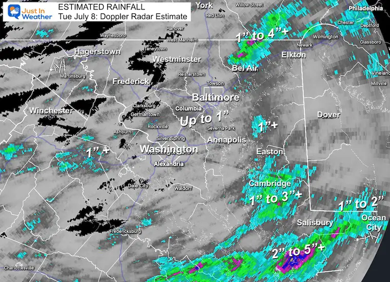
Rainfall On Tuesday: Doppler Radar Estimate
Officially, there was 0.37” of rain in Baltimore at BWI. However, notice the pockets of heavier rain where the totals ranged from 1 to 3 inches, with the top spot being over 4 inches in northern Harford County. Yes, it does seem like this northeast corner of Maryland has a target on its back with multiple extreme weather events recently.
This helps demonstrate how local areas can pulse with much higher amounts, but this will not apply to everyone.
Alerts: A Lot Like Yesterday:
NOAA Severe Storm Risk
The energy is available for storms to produce damaging wind gusts to 60 mph, large hail over 1 inch diameter, and isolated tornadoes.
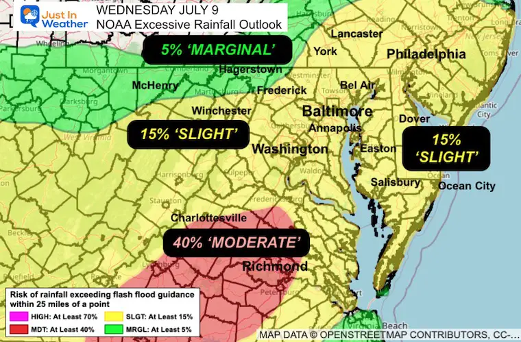
Excessive Rainfall Outlook
Odds that flood potential will be reached.
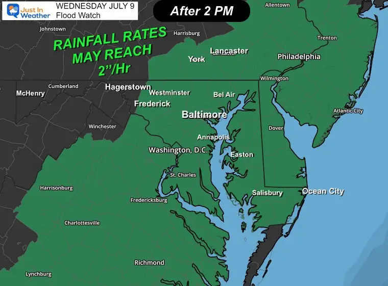
Flood Watch
Rainfall rates may reach 2 inches per hour again.
This looks like the same region as yesterday, with the addition of the Lower Eastern Shore, considering the heavy rain they had seen yesterday between Salisbury and Ocean City.
Live Radar and Lightning Widget
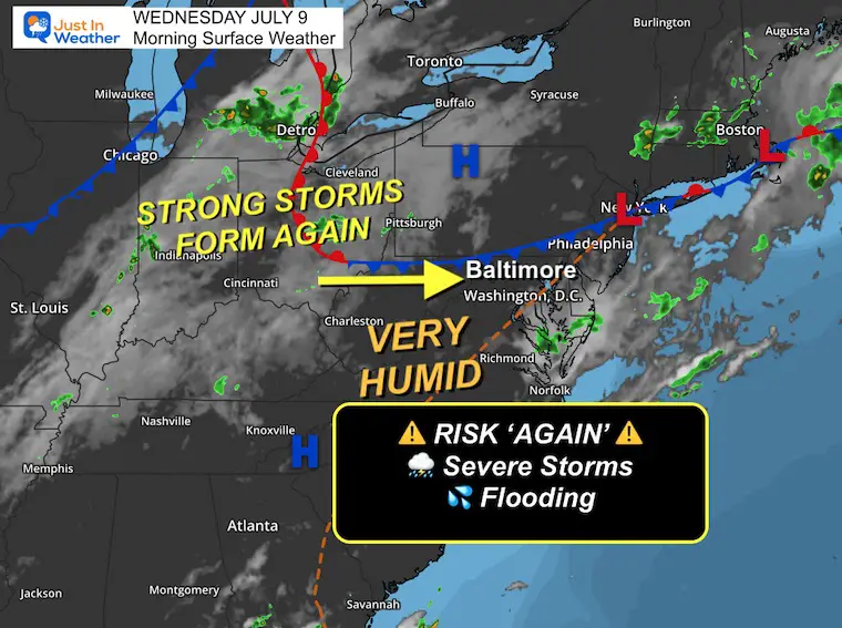
Surface Weather
A cold front is nearly stationary and will be the instigator for more rain today.
Lines of showers and thunderstorms will develop and blossom in the same area of the Mid-Atlantic.
The high humidity will help produce rainfall rates close to 2 inches per hour.
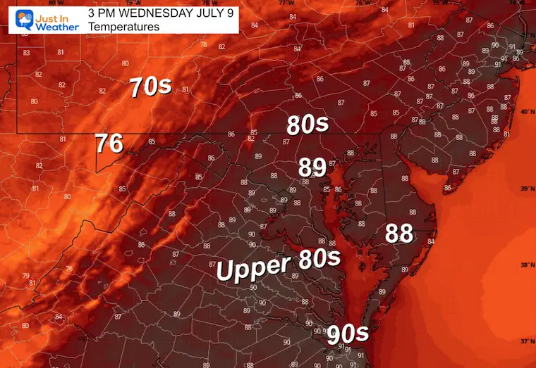
High Temperatures
Heat Index
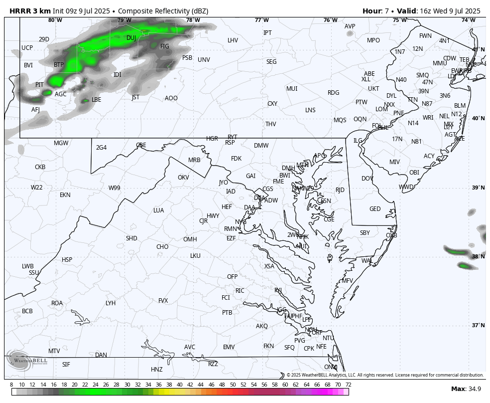
Radar Simulation
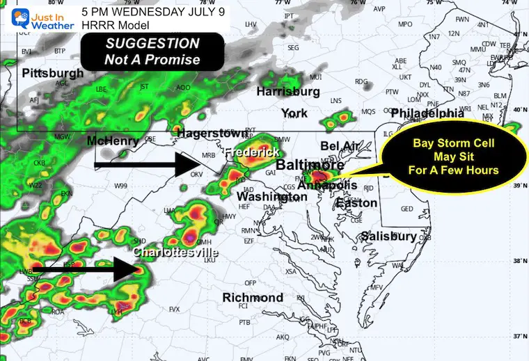
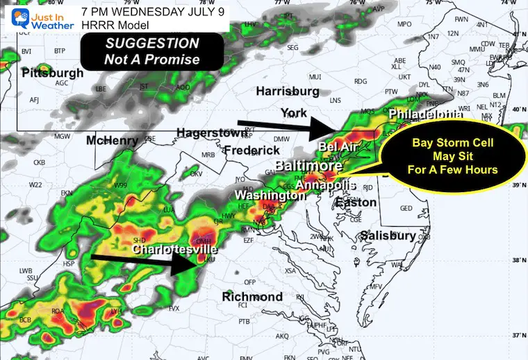
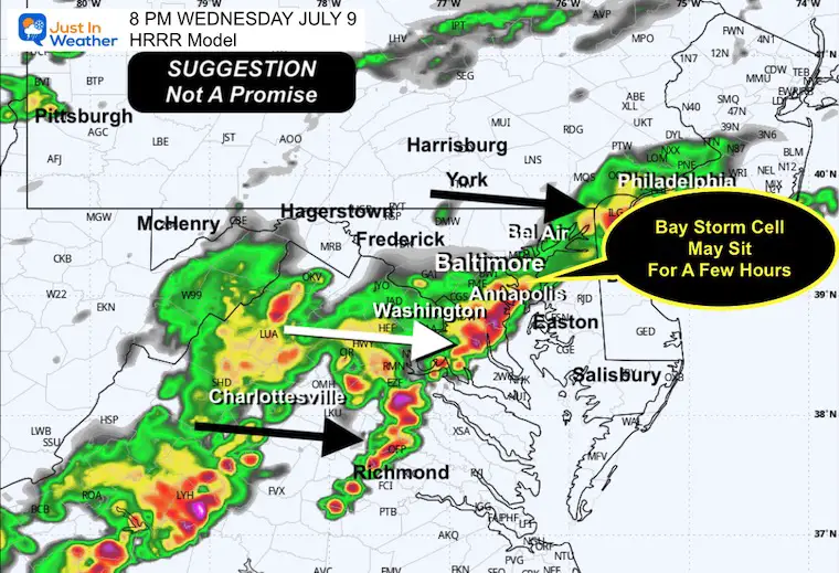
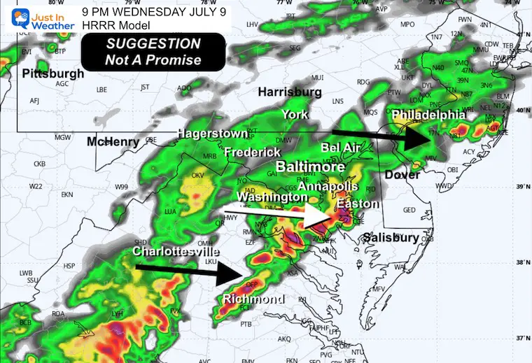
HRRR Model Noon to 11 PM
Focus after 3 PM in the risk zone. Some cells may form and stall near the Bay between Baltimore and Annapolis. Then the rain will shift to the Eastern Shore and Beaches in the evening and at night.
Snapshot at 5 PM
Snapshot at 7 PM
Snapshot at 8 PM
Snapshot at 9 PM
CLIMATE DATA: Baltimore
Yesterday: Low 75℉; High 96℉
Rainfall = 0.37”
TODAY July 9
Sunrise at 5:48 AM
Sunset at 8:35 PM
Normal Low in Baltimore: 68ºF
Record 54ºF in 1984
Normal High in Baltimore: 89ºF
Record 103ºF 1936
Rainfall Deficit at BWI
- Ending 2024 = -8.00”
- Since Jan 1 = -1.71”
- We are STILL DOWN -9.71” INCLUDING LAST YEAR
Subscribe for eMail Alerts
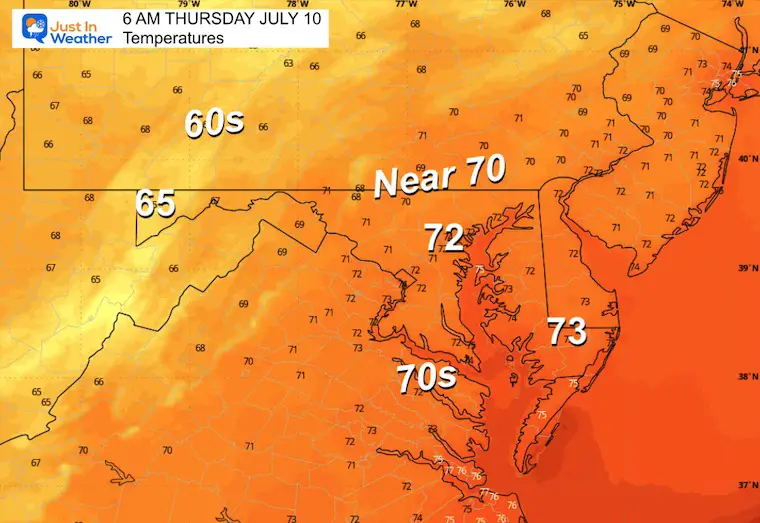
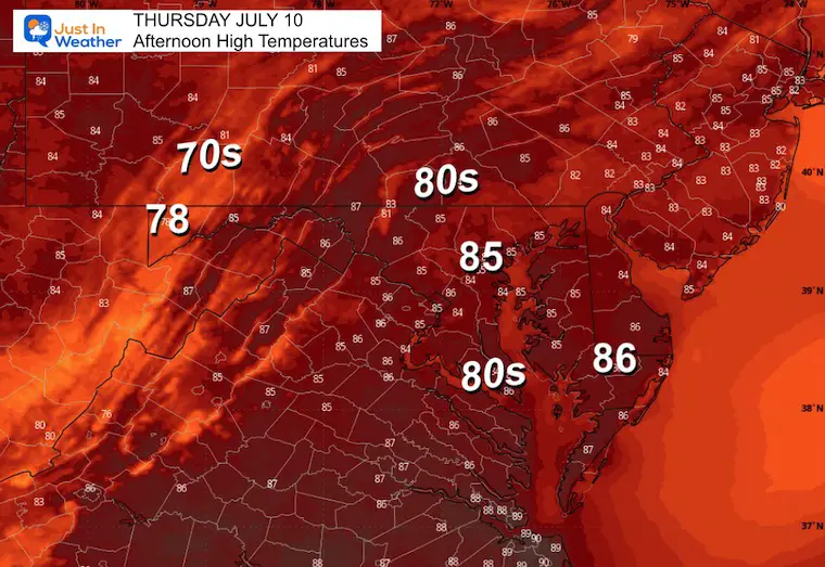
THURSDAY
Morning Temperatures
Afternoon Temperatures
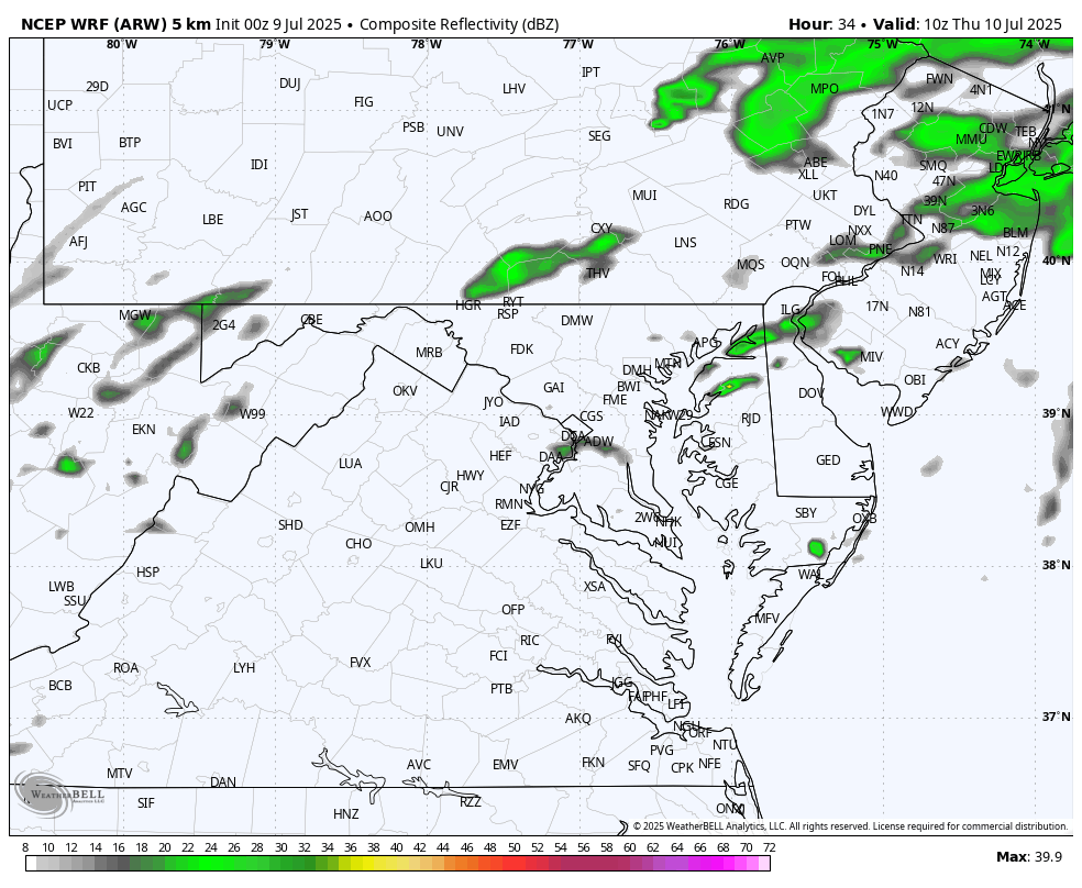
Radar Simulation 6 AM to 8 PM
‘SUGGESTION’ Not A Promise
More lines of heavy showers and thunderstorms in the afternoon and evening.
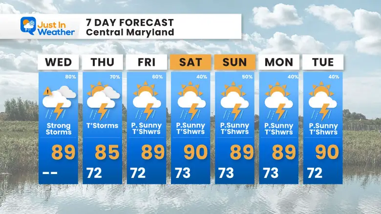
Thursday to Sunday: Active Week Of Storms
Daily thundershowers in the afternoons and evenings, the rest of the week.
7 Day Forecast
Daily showers and thunderstorms are likely.
Subscribe for eMail Alerts
Please share your thoughts and best weather pics/videos, or just keep in touch via social media.
THANK YOU:
Baltimore Sun Magazine Readers Choice Best Of Baltimore
Maryland Trek 11 Day 7 Completed Sat August 10
We raised OVER $111,000 for Just In Power Kids – AND Still Collecting More
The annual event: Hiking and biking 329 miles in 7 days between The Summit of Wisp to Ocean City.
Each day, we honor a kid and their family’s cancer journey.
Fundraising is for Just In Power Kids: Funding Free Holistic Programs. I never have and never will take a penny. It is all for our nonprofit to operate.
Click here or the image to donate:

RESTATING MY MESSAGE ABOUT DYSLEXIA
I am aware there are some spelling and grammar typos and occasional other glitches. I take responsibility for my mistakes and even the computer glitches I may miss. I have made a few public statements over the years, but if you are new here, you may have missed it: I have dyslexia and found out during my second year at Cornell University. It didn’t stop me from getting my meteorology degree and being the first to get the AMS CBM in the Baltimore/Washington region. One of my professors told me that I had made it that far without knowing and to not let it be a crutch going forward. That was Mark Wysocki, and he was absolutely correct! I do miss my mistakes in my own proofreading. The autocorrect spell check on my computer sometimes does an injustice to make it worse. I also can make mistakes in forecasting. No one is perfect at predicting the future. All of the maps and information are accurate. The ‘wordy’ stuff can get sticky. There has been no editor who can check my work while writing and to have it ready to send out in a newsworthy timeline. Barbara Werner is a member of the web team that helps me maintain this site. She has taken it upon herself to edit typos when she is available. That could be AFTER you read this. I accept this and perhaps proves what you read is really from me… It’s part of my charm. #FITF


