Thursday, June 26, 2025
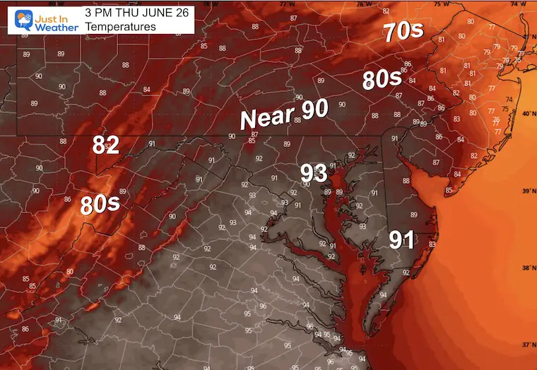
A record high of 99°F was tied on Wednesday, and now we begin to step things down. Relief is on the way in the form of a backdoor cold front coming from New England, and temperatures may be 20 degrees cooler tomorrow. But it is not here yet!
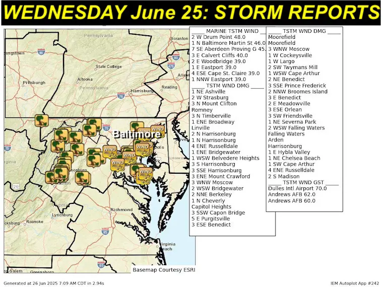
Storm Reports From Wednesday
Here are the regional wind and storm reports, mostly for wind damage. This was with a marginal risk of severe storms, and we have a similar risk assessment today.
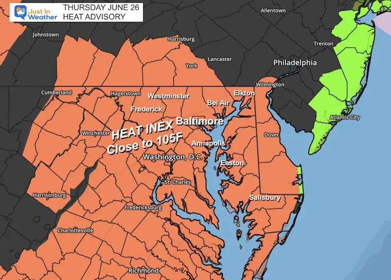
Today may be the last day for a while with Heat Alerts. The Heat Advisory is for heat index values up to 105℉.
As we break the heat and get into a more active pattern, daily thunderstorms will pop up in the afternoons and evenings. It is IMPOSSIBLE to guarantee any location and if or when they may happen. These are subject to daily heat bubbles and other small pieces of energy in the atmosphere. The best I can suggest is to have a safety plan to get indoors quickly if you are expecting to be outside.
HEAT ALERTS:
Heat Advisory: Heat Index up to 105℉
Please Remember Your Kids and Pets
Children: CHECK THE BACKSEAT OF YOUR CAR! DO NOT LEAVE A KID IN THE CAR!
Pets: The pavement will be HOT as well and paws can burn. Limit the outside time for our furry friends to early morning or evening.
TODAY’S Weather
Live Radar and Lightning Widget
Morning Surface Weather
A Back Door Cold Front will be dropping southward from New England. This new air mass will shift our winds FROM the East off the Atlantic. The result will be cooler air tomorrow.
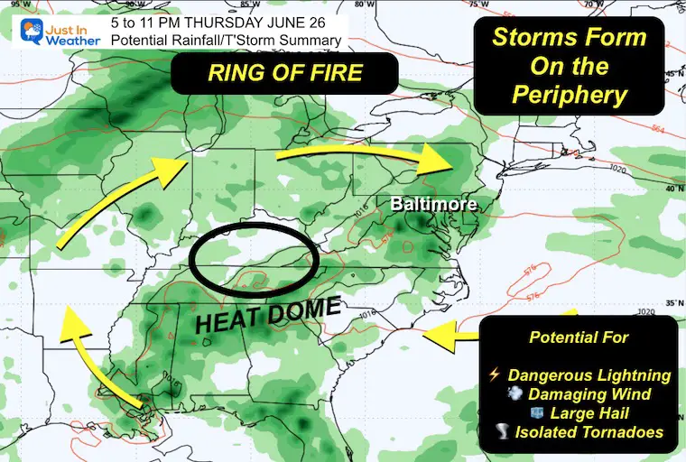
The Heat Dome is shifting, and so will the Ring of Fire. This is where the focus of daily showers and thunderstorms will fire up.
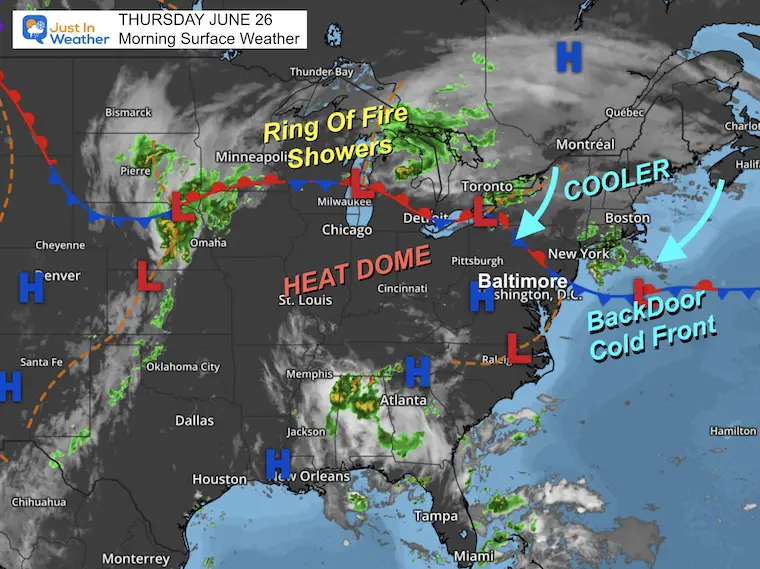
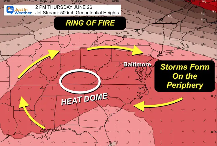
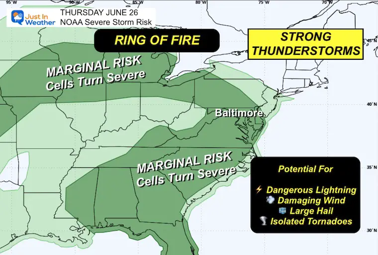
Ring Of Fire
The Heat Dome will shift west and south, allowing the active storm track to expand over our region.
NOAA Severe Storm Risk
While the risk is only Marginal, there is a chance any thunderstorm (like yesterday) may contain damaging wind, large hail, or an isolated tornado.
Any storm has the potential for dangerous lightning and flash flooding.
Expected Storms This Evening
Afternoon High Temperatures
Heat Index

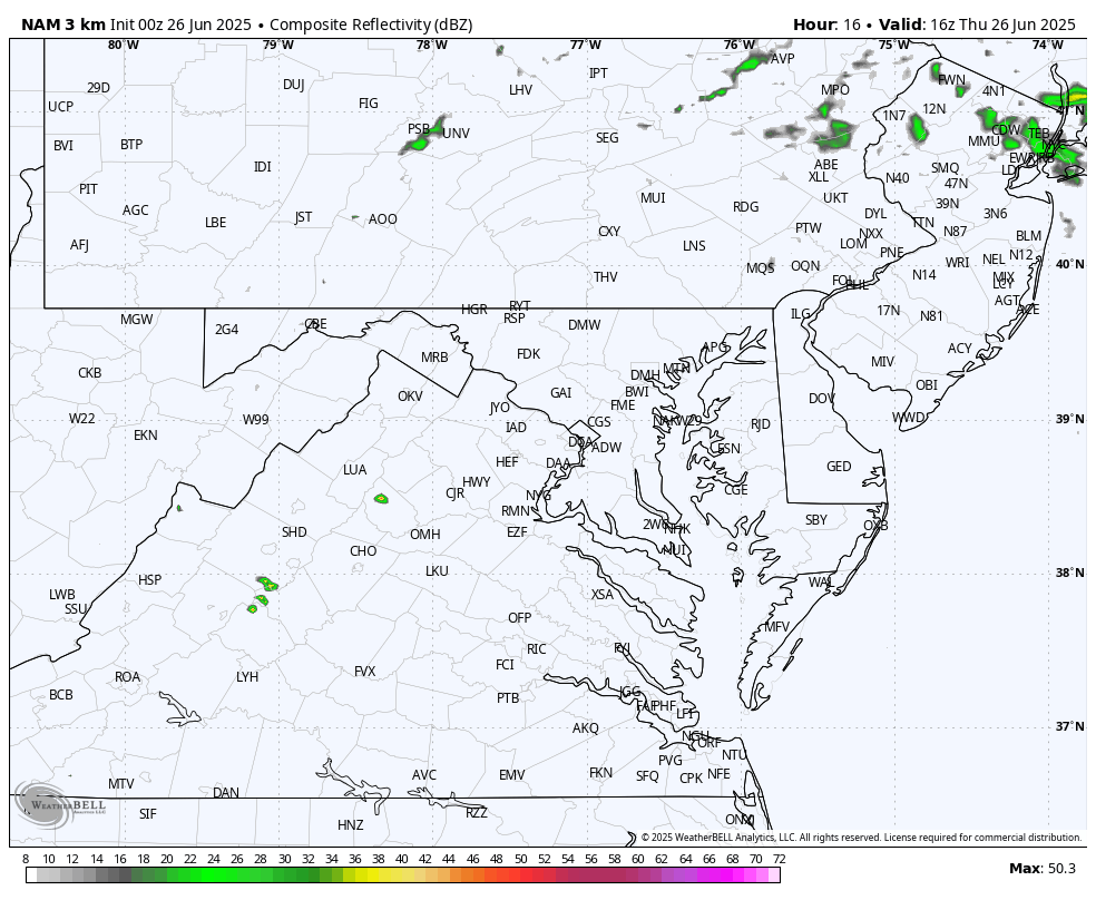
Radar Simulation: Noon to Midnight
This is only a suggestion and not a promise. There will be storms that pop up and are not shown here. Just have a backup plan for safety if you are outside.
Subscribe for eMail Alerts
CLIMATE DATA: Baltimore
TODAY June 26
Sunrise at 5:42 AM
Sunset at 8:37 PM
Normal Low in Baltimore: 65ºF
Record 52ºF in 1979; 1986
Normal High in Baltimore: 88ºF
Record 99ºF 1952; 1954; 2924
Rainfall Deficit at BWI
- Ending 2024 = -8.00”
- Since Jan 1 = -2.10”
- We are STILL DOWN -10.01” INCLUDING LAST YEAR
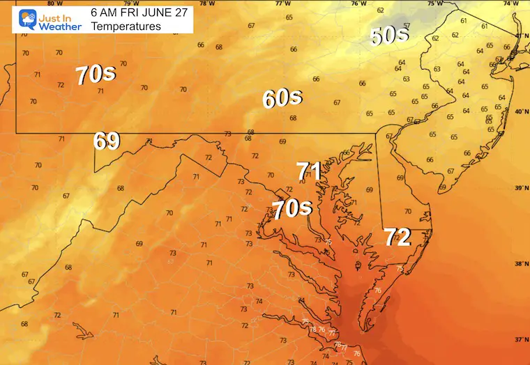
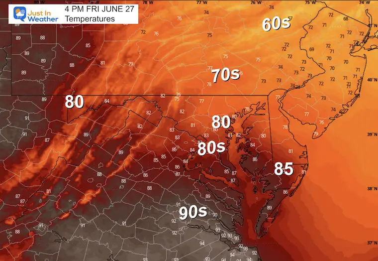
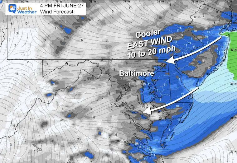
FRIDAY
Morning Low Temperatures
Afternoon High Temperatures
Afternoon Wind
This Easterly Flow is what will bring our temperatures back down to more comfortable levels.
LOOKING AHEAD
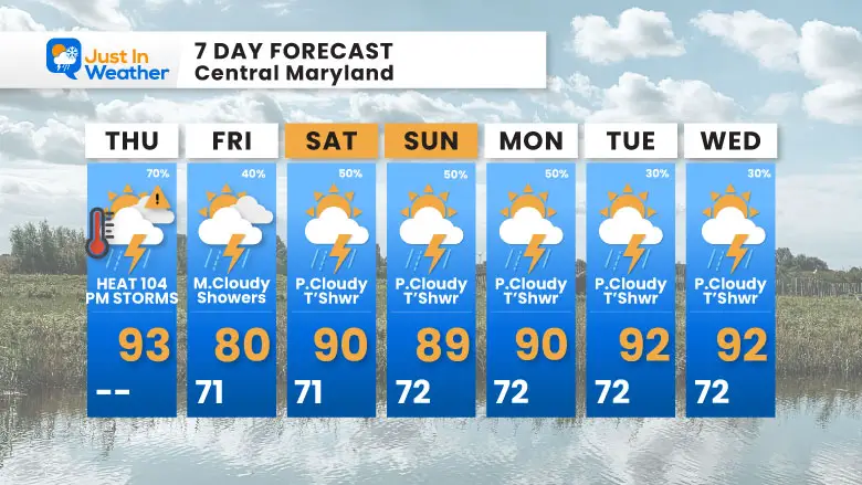
7 Day Forecast
- Today: Heat And Storms
- Slightly Cooler With Daily thunderstorms the rest of the period.
Subscribe for eMail Alerts
Please share your thoughts and best weather pics/videos, or just keep in touch via social media.
THANK YOU:
Baltimore Sun Magazine Readers Choice Best Of Baltimore
Maryland Trek 11 Day 7 Completed Sat August 10
We raised OVER $111,000 for Just In Power Kids – AND Still Collecting More
The annual event: Hiking and biking 329 miles in 7 days between The Summit of Wisp to Ocean City.
Each day, we honor a kid and their family’s cancer journey.
Fundraising is for Just In Power Kids: Funding Free Holistic Programs. I never have and never will take a penny. It is all for our nonprofit to operate.
Click here or the image to donate:

RESTATING MY MESSAGE ABOUT DYSLEXIA
I am aware there are some spelling and grammar typos and occasional other glitches. I take responsibility for my mistakes and even the computer glitches I may miss. I have made a few public statements over the years, but if you are new here, you may have missed it: I have dyslexia and found out during my second year at Cornell University. It didn’t stop me from getting my meteorology degree and being the first to get the AMS CBM in the Baltimore/Washington region. One of my professors told me that I had made it that far without knowing and to not let it be a crutch going forward. That was Mark Wysocki, and he was absolutely correct! I do miss my mistakes in my own proofreading. The autocorrect spell check on my computer sometimes does an injustice to make it worse. I also can make mistakes in forecasting. No one is perfect at predicting the future. All of the maps and information are accurate. The ‘wordy’ stuff can get sticky. There has been no editor who can check my work while writing and to have it ready to send out in a newsworthy timeline. Barbara Werner is a member of the web team that helps me maintain this site. She has taken it upon herself to edit typos when she is available. That could be AFTER you read this. I accept this and perhaps proves what you read is really from me… It’s part of my charm. #FITF


