Wednesday, May 28, 2025
I am not sure if you saw my afternoon update on social media. Yesterday, the rain moved in faster than the models suggested. I spotted this early in the afternoon, as it did make for a soggy end to the day.
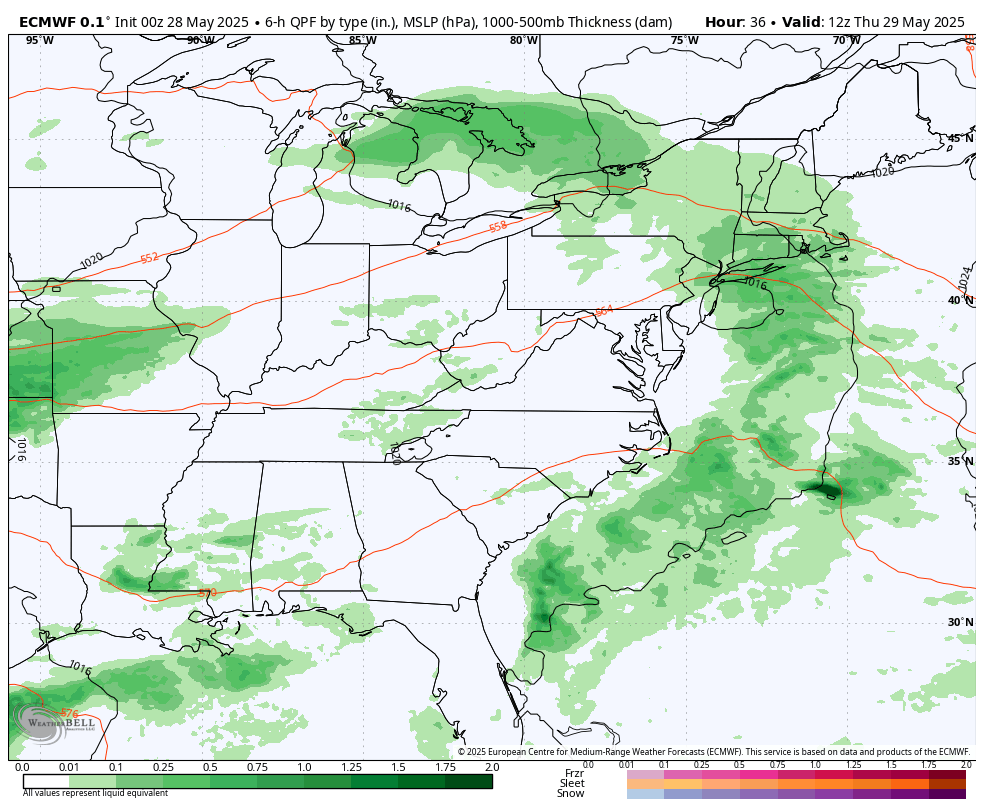
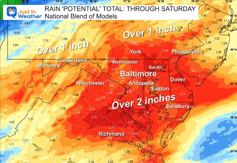
The only change I see going forward is the increase in total expectations through Saturday, with over 2 inches for much of the region.
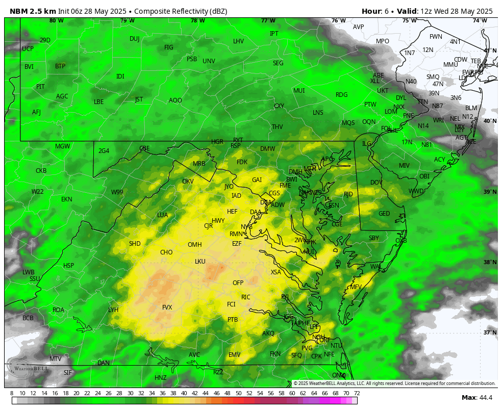
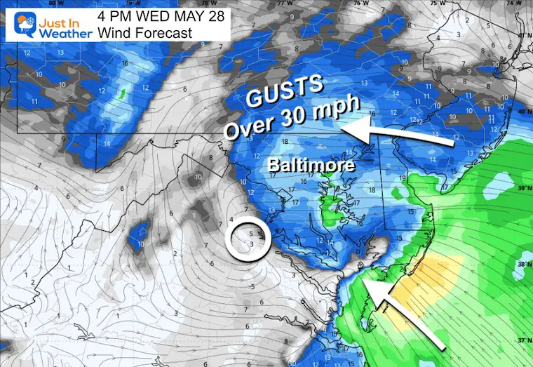
The main event is today, with steady rain that will be heavy at times. Low Pressure will pull in a strong wind from the East that may gust over 30 mph.
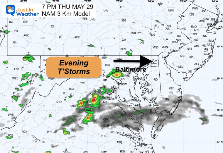
We will get a break on Thursday, limiting the chance of rain to an evening thunderstorm. The two more areas of Low Pressure will bring back more rain and heavier thunderstorms on Friday and Saturday.
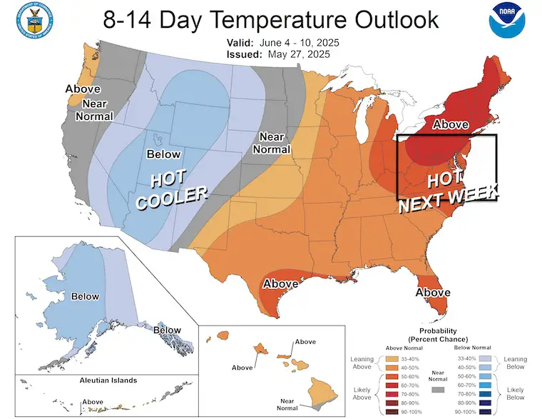
A pattern change may be noticeable Sunday with the sun returning, then increasing confidence of summer heat by the middle of next week.
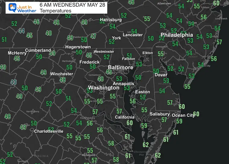
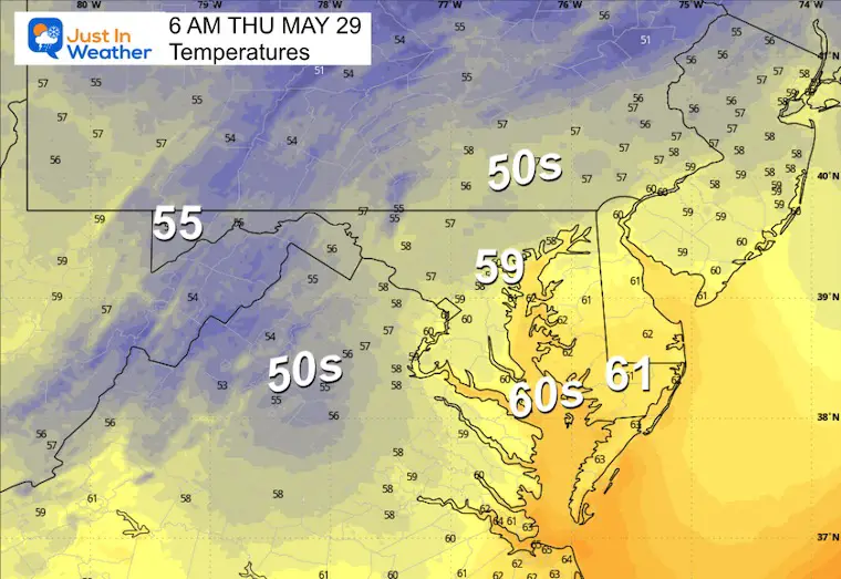
Morning Temperatures
A chilly and wet start. Not much movement on the thermometer today due to the rain.
Live Radar Widget
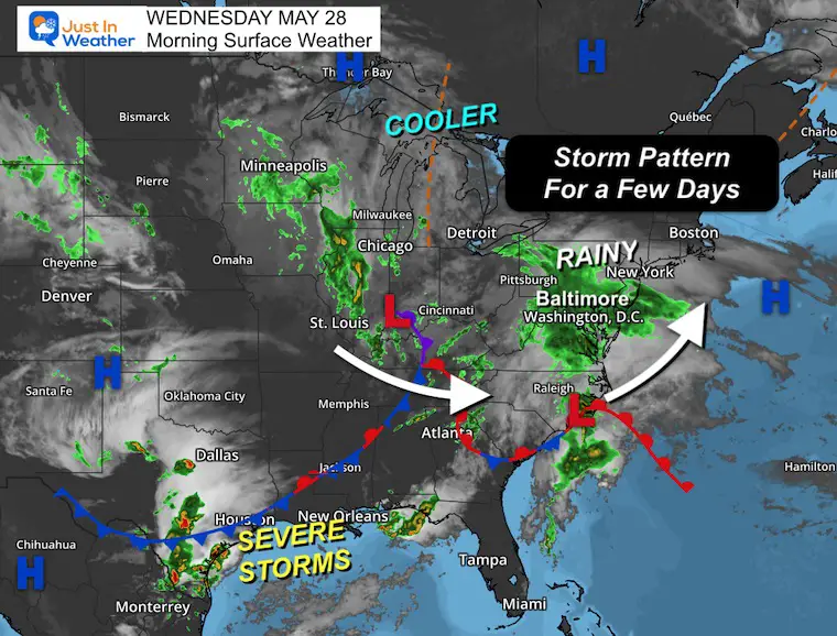
Morning Surface Weather
A very active and unseasonable pattern will keep a surge of cooler air and multiple areas of Low Pressure swinging through the Mid-Atlantic today through Saturday.
The severe storms have already started across Southeast Texas and will continue through the Gulf Coast States.
Radar Simulation 8 AM to Midnight
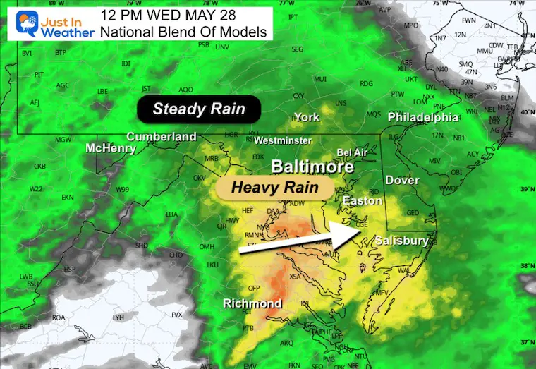
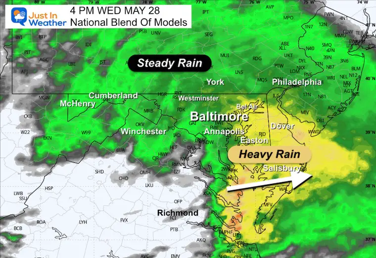
Steady rain much of the day, with the heaviest passing across Southern Maryland and Delmarva.
Snapshots:
Noon
4 PM
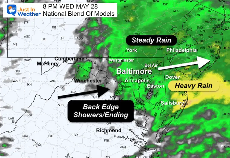
Watching the back edge of rain moving through as Low Pressure passes across Southern Maryland.
Wind Forecast
Low Pressure will pull the wind in from the ocean and gust over 30 mph.
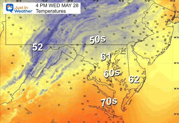
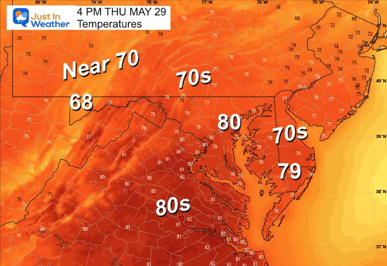
Afternoon High Temperatures
Chilly lower 60s with the rain and wind from the ocean.
Remaining in the 50s for the interior and northern suburbs.
8 PM
Steady rain moves east, and the back edge of showers will move through metro areas.
CLIMATE DATA: Baltimore
TODAY May 28
Sunrise at 5:44 AM
Sunset at 8:24 PM
Normal Low in Baltimore: 57ºF
Record 38ºF in 1961
Normal High in Baltimore: 79ºF
Record 97ºF 1941
Drought UPDATE: Map Was Updated Thursday
Rainfall Deficit at BWI
- Ending 2024 = -8.00”
- Since Jan 1 = -2.76”
- We are DOWN -10.76” including last year
Subscribe for eMail Alerts
WEDNESDAY
Morning Low Temps
Afternoon Temperatures
Radar Simulation ‘Suggestion’
LOOKING AHEAD
Storm Forecast: Thursday Morning to Sunday
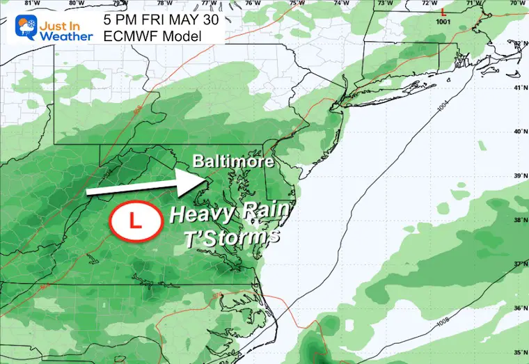
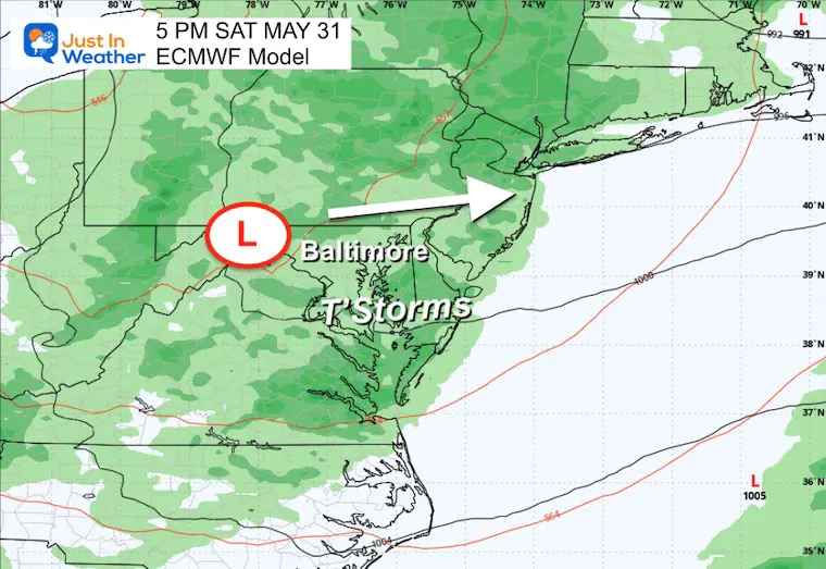
An active weather pattern will bring another round of rain with two areas of Low Pressure swinging through Friday and Saturday.
Snapshots
Friday Afternoon
More rain and thunderstorms.
Saturday Afternoon
Another round of rain and thunderstorms.
Rain POTENTIAL Forecast Through Saturday
This has increased to over 2 inches for more of our region.
NOAA Temperature Outlook
June 4 to 10: Summer heat is expected to show up by the middle of NEXT WEEK.
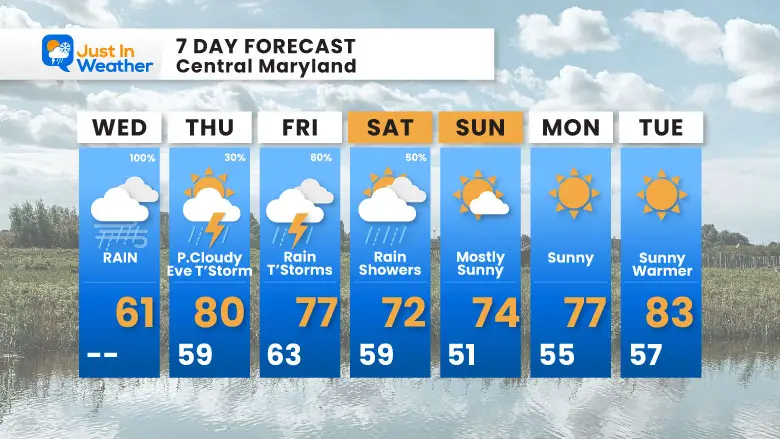
7 Day Forecast
- Today: Steady Rain, Heavy At Times
- Thursday to Saturday: Showers and Thunderstorms
- Sunday/Monday Improvement
- Summer heat arrives in the middle of next week.
Subscribe for eMail Alerts
Please share your thoughts and best weather pics/videos, or just keep in touch via social media.
SCHEDULE A WEATHER BASED STEM ASSEMBLY
Severe Weather: Storm Smart October and next spring Winter Weather FITF (Faith in the Flakes): November To March Click to see more and send a request for your school.

THANK YOU:
Baltimore Magazine Readers Choice Best Of Baltimore
Maryland Trek 11 Day 7 Completed Sat August 10
We raised OVER $111,000 for Just In Power Kids – AND Still Collecting More
The annual event: Hiking and biking 329 miles in 7 days between The Summit of Wisp to Ocean City.
Each day, we honor a kid and their family’s cancer journey.
Fundraising is for Just In Power Kids: Funding Free Holistic Programs. I never have and never will take a penny. It is all for our nonprofit to operate.
Click here or the image to donate:

RESTATING MY MESSAGE ABOUT DYSLEXIA
I am aware there are some spelling and grammar typos and occasional other glitches. I take responsibility for my mistakes and even the computer glitches I may miss. I have made a few public statements over the years, but if you are new here, you may have missed it: I have dyslexia and found out during my second year at Cornell University. It didn’t stop me from getting my meteorology degree and being the first to get the AMS CBM in the Baltimore/Washington region. One of my professors told me that I had made it that far without knowing and to not let it be a crutch going forward. That was Mark Wysocki, and he was absolutely correct! I do miss my mistakes in my own proofreading. The autocorrect spell check on my computer sometimes does an injustice to make it worse. I also can make mistakes in forecasting. No one is perfect at predicting the future. All of the maps and information are accurate. The ‘wordy’ stuff can get sticky. There has been no editor who can check my work while writing and to have it ready to send out in a newsworthy timeline. Barbara Werner is a member of the web team that helps me maintain this site. She has taken it upon herself to edit typos when she is available. That could be AFTER you read this. I accept this and perhaps proves what you read is really from me… It’s part of my charm. #FITF


