The severe storms were expected and multiple rounds tracked across Maryland on Friday. In this report, I gathered all the media that I posted across social media along with the radar recap, storm map, and list of reports so you can refer to it all in one place.
Day Of Storms: Radar Recap 8 AM to 8 PM
This day began with a cluster of storms around sunrise near the New York and Pennsylvania border that expanded in a line southward into Maryland. This eventually led to the first round of tornado warnings and severe storm alerts in Delaware and coastal Maryland near Ocean City.
Then, severe storms erupted midday and in the afternoon. This included large hail up to the size of golf balls (over 2 inches) in Carroll and Baltimore Counties.
The next round of flare-ups occurred late afternoon and evening in Central Maryland and led to widespread destruction. This included winds close to 70 mph and tornado warnings in Baltimore City and southeast Baltimore County.
The most destruction was seen in Dundalk, where roofs were torn off, trees were uprooted, and debris was scattered across a wide area. I have a home video showing that below. There was also destruction to the roof of Merritt Athletic Club in Canton (downtown Baltimore), and the building has been condemned.
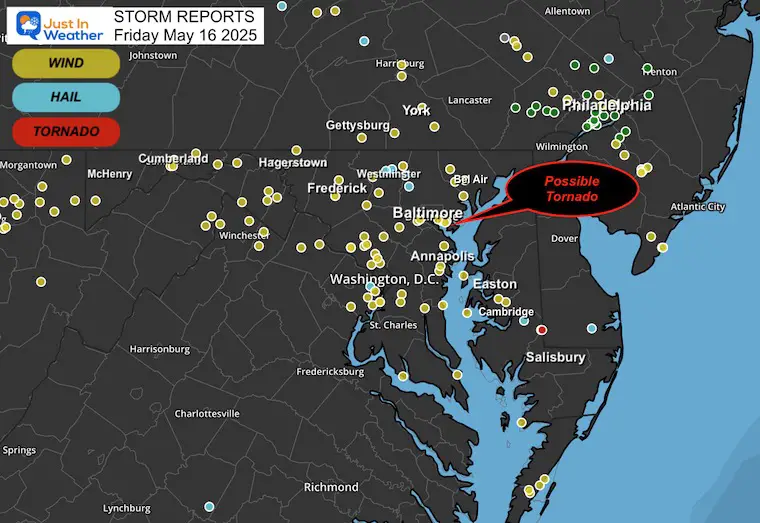
Storm Reports
This is the summary of wind, hail, and tornado reports gathered by NOAA and the National Weather Service.
It is important to note that the National Weather Service will send a crew to suspected areas where a tornado may have occurred. They will survey the damage and then confirm whether a tornado touched down and how strong it was.
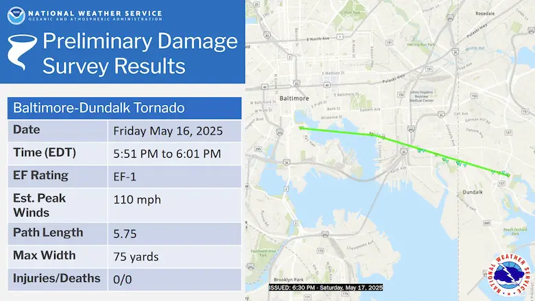
UPDATE: TORNADO CONFIRMED
NWS Confirmed an EF-1 Tornado formed over Baltimore in Federal Hill, then dissipated over Dundalk.
- EF – 1
- Winds 110 mph
- Path: 5.75 miles long; 75 yards wide
Dundalk Destruction: Wind Video
This video shows the wind picking up and moving furniture on his porch. Then, the awning lifts up, and eventually, the awning/roof drops onto the porch.
Video from John L Goff Jr
WBAL Video Of Merritt Athletic Club
Flooding from Roof Damage
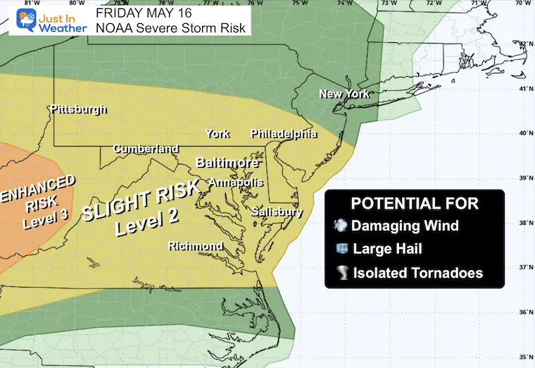
Reminder Maps
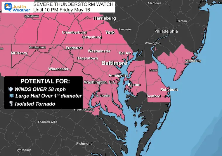
NOAA had A Risk For Severe Storms In Our Region
A Severe Thunderstorm Watch Was Issued For The Afternoon And Evening
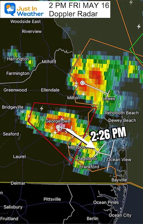
Delaware Tornado Warning
2 PM Friday Doppler Radar. A Tornado Warning was in place and included Georgetown to Millsboro. A Severe Thunderstorm Warning was issued shortly after for Lewes, Rehoboth, and Dewey Beach on the coast.
Click the image for the full post and collection of comments/first-hand accounts.
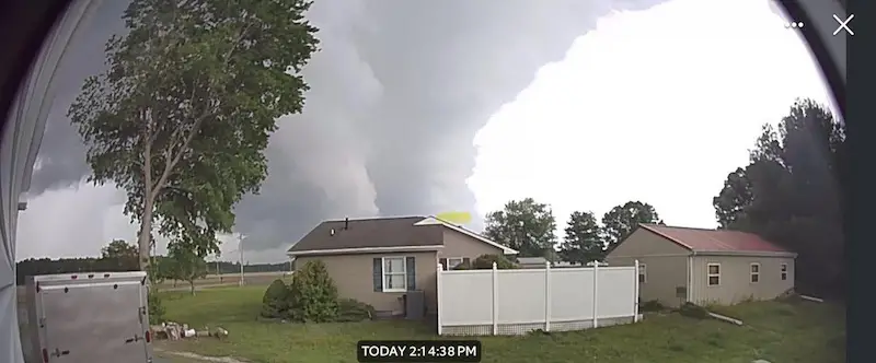
Storm Clouds: Georgetown, Delaware at 2:14 PM
Courtesy of Heather Tunis-Sheets.
Click on the image for the social media post and comments with first-hand reports.
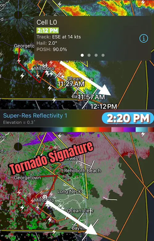
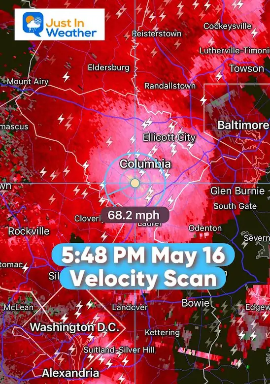
Velocity Scan: Tornado Hook Signature
Follow Up Warnings

Large Hail in Carroll and Baltimore Counties
Howard County Winds
Doppler Radar ESTIMATED Wind Gusts to 68 mph near Columbia. This is the cell that tracked EAST across Baltimore next…
Baltimore Storm Views
Lightning, Shelf Clouds, And Storm Damage
Tornado Warning: Baltimore, Dundalk, Edgemere
This was the post I made on Facebook, as this was tracking from Downtown Baltimore to Southeast Baltimore County.
Numerous comments helped confirm the storm damage.
STORM REPORTS FROM NOAA And The Storm Prediction Center
|
FUNNEL CLOUD
|
0
|
Galestown
|
MD
|
2025-05-16 22:55:00Z
|
Reports of a funnel cloud spotted near Galestown, MD.
|
|
HAIL
|
1
|
4 ENE Westminster
|
MD
|
2025-05-16 21:12:00Z
|
|
|
HAIL
|
1
|
Easton
|
MD
|
2025-05-16 22:10:00Z
|
Report sent on social media of 1-inch hail.
|
|
HAIL
|
1.5
|
1 NNE Westminster
|
MD
|
2025-05-16 21:11:00Z
|
|
|
HAIL
|
1.5
|
Preston
|
MD
|
2025-05-16 22:40:00Z
|
1.5 inch hail reported. Time estimated from radar.
|
|
HAIL
|
1
|
2 N Reisterstown
|
MD
|
2025-05-16 21:34:00Z
|
|
|
HAIL
|
1.75
|
1 ENE Hurlock
|
MD
|
2025-05-16 23:00:00Z
|
Picture of hail received via social media in Hurlock MD.
|
|
HAIL
|
2.5
|
4 SSE Hampstead
|
MD
|
2025-05-16 21:28:00Z
|
|
|
MARINE TSTM WIND
|
58
|
5 ESE Bay Ridge
|
MD
|
2025-05-16 22:14:00Z
|
|
|
MARINE TSTM WIND
|
45
|
2 NNE North Beach
|
MD
|
2025-05-16 22:13:00Z
|
|
|
MARINE TSTM WIND
|
39
|
Saunders Point Light
|
MD
|
2025-05-16 22:18:00Z
|
|
|
MARINE TSTM WIND
|
43
|
6 NNE Ocean City
|
MD
|
2025-05-16 23:29:00Z
|
|
|
MARINE TSTM WIND
|
52
|
Swan Point
|
MD
|
2025-05-16 21:39:00Z
|
|
|
MARINE TSTM WIND
|
48
|
8 E Smith Island
|
MD
|
2025-05-16 22:43:00Z
|
|
|
MARINE TSTM WIND
|
48
|
4 S Middle River
|
MD
|
2025-05-16 22:09:00Z
|
|
|
MARINE TSTM WIND
|
72
|
10 ENE Plum Point
|
MD
|
2025-05-16 22:33:00Z
|
|
|
MARINE TSTM WIND
|
49
|
7 SE Aberdeen Proving Ground
|
MD
|
2025-05-16 22:24:00Z
|
|
|
MARINE TSTM WIND
|
44
|
1 E Eastport
|
MD
|
2025-05-16 22:12:00Z
|
|
|
MARINE TSTM WIND
|
53
|
2 SE Cobb Island
|
MD
|
2025-05-16 21:50:00Z
|
|
|
MARINE TSTM WIND
|
54
|
4 ESE Cape St. Claire
|
MD
|
2025-05-16 21:47:00Z
|
|
|
MARINE TSTM WIND
|
46
|
2 N Cove Point
|
MD
|
2025-05-16 23:38:00Z
|
|
|
MARINE TSTM WIND
|
46
|
17 NE Smith Island
|
MD
|
2025-05-16 22:53:00Z
|
|
|
TSTM WND DMG
|
0
|
2 N Garrett Park
|
MD
|
2025-05-16 21:30:00Z
|
Tree branches downed onto power lines along 4400 block of Edgebrook Road.
|
|
TSTM WND DMG
|
0
|
Little Orleans
|
MD
|
2025-05-16 19:59:00Z
|
Multiple trees down around Little Orleans.
|
|
TSTM WND DMG
|
0
|
3 NW Columbia
|
MD
|
2025-05-16 21:31:00Z
|
Several trees downed on Harpers Farm Road.
|
|
TSTM WND DMG
|
0
|
Piney Point
|
MD
|
2025-05-16 22:05:00Z
|
Several trees downed in Piney Point area.
|
|
TSTM WND DMG
|
0
|
Mount Airy
|
MD
|
2025-05-16 20:58:00Z
|
Trees reported down on Ridge Ave. in Mt. Airy.
|
|
TSTM WND DMG
|
0
|
Denton
|
MD
|
2025-05-16 22:55:00Z
|
Trees and wires down. Time estimated from radar.
|
|
TSTM WND DMG
|
0
|
Hampstead
|
MD
|
2025-05-16 21:34:00Z
|
Carroll County EM reports numerous trees downed in the Hampstead area.
|
|
TSTM WND DMG
|
0
|
1 WSW Dunkirk
|
MD
|
2025-05-16 22:00:00Z
|
Large tree and several power lines downed along Ferry Landing Road in Dunkirk.
|
|
TSTM WND DMG
|
0
|
Dundalk
|
MD
|
2025-05-16 22:06:00Z
|
Roofs blown off a couple row houses, trees downed, and other minor structural damage on Fairway in Old Dundalk Next to Yorkway along with Yorkway and Sellers Point Road.
|
|
TSTM WND DMG
|
0
|
2 NE Catonsville
|
MD
|
2025-05-16 21:48:00Z
|
Siding partially removed off an apartment building near the 140 block of Nunnery Lane.
|
|
TSTM WND DMG
|
0
|
1 N Londontowne
|
MD
|
2025-05-16 22:10:00Z
|
Several trees and power lines downed near 2900th block of Main Street in Edgewater.
|
|
TSTM WND DMG
|
0
|
Oakland
|
MD
|
2025-05-16 19:05:00Z
|
Tree down on wires.
|
|
TSTM WND DMG
|
0
|
Bethesda
|
MD
|
2025-05-16 21:29:00Z
|
1 foot diameter tree down.
|
|
TSTM WND DMG
|
0
|
1 N Fells Point
|
MD
|
2025-05-16 21:52:00Z
|
Metal roof on gym partially removed.
|
|
TSTM WND DMG
|
0
|
Jarrettsville
|
MD
|
2025-05-16 21:52:00Z
|
Reports of trees down in the Jarrettsville.
|
|
TSTM WND DMG
|
0
|
Utica
|
MD
|
2025-05-16 20:57:00Z
|
Several trees reported down along the US-15 corridor from Utica to Frederick.
|
|
TSTM WND DMG
|
0
|
6 WSW Westminster
|
MD
|
2025-05-16 21:19:00Z
|
Multiple reports of power lines down in New Windsor, MD.
|
|
TSTM WND DMG
|
0
|
1 N Fells Point
|
MD
|
2025-05-16 21:53:00Z
|
Damage to building along Boston Street and S Clinton St
|
|
TSTM WND DMG
|
0
|
1 NNW Chelsea Beach
|
MD
|
2025-05-16 22:01:00Z
|
Tree downed onto power lines at intersection of Soaper Ave and Magothy Beach Rd in Pasadena.
|
|
TSTM WND DMG
|
0
|
Fallston
|
MD
|
2025-05-16 21:57:00Z
|
Reports of trees down in the Fallston area.
|
|
TSTM WND DMG
|
0
|
2 N Rockville
|
MD
|
2025-05-16 21:21:00Z
|
Around a dozen trees downed in the Deerwood area.
|
|
TSTM WND DMG
|
0
|
3 SE Gaithersburg
|
MD
|
2025-05-16 21:21:00Z
|
Numerous reports of downed trees in Derwood
|
|
TSTM WND DMG
|
0
|
Flintstone
|
MD
|
2025-05-16 19:51:00Z
|
Numerous trees downed around Flintstone.
|
|
TSTM WND DMG
|
0
|
4 SSE Tompkinsville
|
MD
|
2025-05-16 21:43:00Z
|
Two trees down at spotter location.
|
|
TSTM WND DMG
|
0
|
Easton
|
MD
|
2025-05-16 22:50:00Z
|
Trees and powerlines down throughout Easton, with two trees on homes. Time estimated from radar.
|
|
TSTM WND DMG
|
0
|
Silver Spring
|
MD
|
2025-05-16 20:46:00Z
|
Power lines reported down in Silver Spring, one of which was a snapped power pole.
|
|
TSTM WND DMG
|
0
|
1 E Fells Point
|
MD
|
2025-05-16 22:10:00Z
|
Trees snapped near the 2100 block of Broening Highway.
|
|
TSTM WND DMG
|
0
|
2 W North Potomac
|
MD
|
2025-05-16 21:20:00Z
|
Wires and tree branches down near the 14000 block of Darnestown Road
|
|
TSTM WND DMG
|
0
|
2 ESE Brookeville
|
MD
|
2025-05-16 21:27:00Z
|
Montgomery County EMS reports a tree onto a house at the 19000 block of New Hampshire Ave.
|
|
TSTM WND DMG
|
0
|
Frederick
|
MD
|
2025-05-16 20:58:00Z
|
Several reports of trees down along the US-15 corridor from Emmittsburg south through Thurmont.
|
|
TSTM WND DMG
|
0
|
Royal Oak
|
MD
|
2025-05-16 22:40:00Z
|
Picture of a snapped tree sent via social media. Time estimated from radar.
|
|
TSTM WND DMG
|
0
|
Frederick
|
MD
|
2025-05-16 20:57:00Z
|
Several trees reported down along the US-15 corridor from Utica to Frederick.
|
|
TSTM WND DMG
|
0
|
Catonsville
|
MD
|
2025-05-16 21:40:00Z
|
Large tree downed on Oak Drive in Catonsville.
|
|
TSTM WND DMG
|
0
|
Bel Air
|
MD
|
2025-05-16 22:00:00Z
|
Reports of trees down in the Bel Air area.
|
|
TSTM WND DMG
|
0
|
2 NE Catonsville
|
MD
|
2025-05-16 21:39:00Z
|
Reports of multiple trees down on Nunnery Lane.
|
|
TSTM WND DMG
|
0
|
1 SE Montgomery Village
|
MD
|
2025-05-16 21:22:00Z
|
Montgomery County EM reports several trees downed in the Flower Hills area. A tree fell onto a house near intersection of Cochrane Ct and Cochrane Way
|
|
TSTM WND DMG
|
0
|
Joppa
|
MD
|
2025-05-16 22:01:00Z
|
Reports of trees down in the Joppa area.
|
|
TSTM WND DMG
|
0
|
1 NE Cumberland
|
MD
|
2025-05-16 19:37:00Z
|
Tree down near the 800 block of Shades Lane.
|
|
TSTM WND DMG
|
0
|
Galestown
|
MD
|
2025-05-16 22:55:00Z
|
Wind damage in the Galestown area of Dorchester County. Time estimated from radar.
|
|
TSTM WND DMG
|
0
|
Kensington
|
MD
|
2025-05-16 20:44:00Z
|
A couple of trees reported down in Kensington.
|
|
TSTM WND DMG
|
0
|
2 W North Potomac
|
MD
|
2025-05-16 21:16:00Z
|
Tree branches onto wires along the 14000 block of Darnestown Road.
|
|
TSTM WND DMG
|
0
|
Winfield
|
MD
|
2025-05-16 21:16:00Z
|
Carroll County EM reports several trees downed from south of Westminster to Winfield.
|
|
TSTM WND DMG
|
0
|
1 WSW Dundalk
|
MD
|
2025-05-16 22:00:00Z
|
Significant tree, power line, and damage to buildings along Merritt Blvd and Meadow Lane.
|
|
TSTM WND GST
|
66
|
Solomons
|
MD
|
2025-05-16 22:22:00Z
|
NDBC sensor (SLIM2) gust to 66 mph.
|
|
TSTM WND GST
|
58
|
2 SE Clinton
|
MD
|
2025-05-16 21:45:00Z
|
|
|
TSTM WND GST
|
62
|
1 SE Parole
|
MD
|
2025-05-16 21:44:00Z
|
MDOT sensor gust to 62 mph.
|
|
TSTM WND GST
|
63
|
Andrews AFB
|
MD
|
2025-05-16 21:47:00Z
|
|
|
TSTM WND GST
|
51
|
Easton
|
MD
|
2025-05-16 22:46:00Z
|
|
|
TSTM WND GST
|
60
|
2 W Tanyard
|
MD
|
2025-05-16 22:47:00Z
|
Subscribe for eMail Alerts
Please share your thoughts and best weather pics/videos, or just keep in touch via social media.
SCHEDULE A WEATHER BASED STEM ASSEMBLY
Severe Weather: Storm Smart October and next spring Winter Weather FITF (Faith in the Flakes): November To March Click to see more and send a request for your school.

THANK YOU:
Baltimore Magazine Readers Choice Best Of Baltimore
Maryland Trek 11 Day 7 Completed Sat August 10
We raised OVER $111,000 for Just In Power Kids – AND Still Collecting More
The annual event: Hiking and biking 329 miles in 7 days between The Summit of Wisp to Ocean City.
Each day, we honor a kid and their family’s cancer journey.
Fundraising is for Just In Power Kids: Funding Free Holistic Programs. I never have and never will take a penny. It is all for our nonprofit to operate.
Click here or the image to donate:

RESTATING MY MESSAGE ABOUT DYSLEXIA
I am aware there are some spelling and grammar typos and occasional other glitches. I take responsibility for my mistakes and even the computer glitches I may miss. I have made a few public statements over the years, but if you are new here, you may have missed it: I have dyslexia and found out during my second year at Cornell University. It didn’t stop me from getting my meteorology degree and being the first to get the AMS CBM in the Baltimore/Washington region. One of my professors told me that I had made it that far without knowing and to not let it be a crutch going forward. That was Mark Wysocki, and he was absolutely correct! I do miss my mistakes in my own proofreading. The autocorrect spell check on my computer sometimes does an injustice to make it worse. I also can make mistakes in forecasting. No one is perfect at predicting the future. All of the maps and information are accurate. The ‘wordy’ stuff can get sticky. There has been no editor who can check my work while writing and to have it ready to send out in a newsworthy timeline. Barbara Werner is a member of the web team that helps me maintain this site. She has taken it upon herself to edit typos when she is available. That could be AFTER you read this. I accept this and perhaps proves what you read is really from me… It’s part of my charm. #FITF


