Sunday Night, February 16 2025
One of the best comments I saw on Facebook about my first report about a storm during Presidents Week was suggesting Lucy set up the football and we are Charlie Brown. You know, running up to kick only to have it pulled away. I told him there may be some truth in that and wish I could find it now to give him credit.
I have new data to share in this report and will explain why we still do not have all the needed information in the grid. First, I hope you indulge me for a little background.
Just two days ago, I started to get serious and call this next weather event a ‘major winter storm. ‘ I still believe it will happen, and the most critical turning point of data is about to arrive tonight and tomorrow morning.
My 15 year old son has been very interested and following models as well for a few days. It has been a great lesson in the limitations of computer models and The Chaos Theory. He has also been very disappointed in the dropping snow potential…. There is just a little more time to wait to see if this will fade south or really try to come back.
I have tracked many winter storms over the last 3 decades and have seen some blockbusters be solid one week away. I have also seen surprises including something too good to be true only appear to fall apart.
I have also seen models lock on a storm, then lose it, only to come back. That is still a possibility, and I will explain it below.
I held off on joining the storm discussion until we were less than one week away, and I felt I had enough data to support this being real. It looked epic. I did mention the words Nor’easter, Hurricane Equivalent Low Pressure, and Blizzard Conditions. Those are all still possible, but when and where this thrives is up for debate.
Yes sometimes a storm looking ‘too good too soon’ can lead to eventual disappointment. Even with my discussion I was still cautious with my words.
NEVER SHOW TOTALS TOO SOON
There is a reason I do not show snow totals more than three days away. I learned this policy many years ago, and it is currently displayed throughout social media.
I NEVER post snow totals more than 72 hours ahead of a storm, but you might have seen other people share maps showing 20 to 30 inches of snow. That was from last week. That is almost always a setup for failure.
What I did lead with was a map showing the Odds of 6” or more based on the reliable European Model with 50 members or different scenarios run. I figured a 50% chance 6 days away was rare and high enough to mention. It also did mean that if you had a 60% chance from Friday, that also means a 40% chance you wouldn’t.
Computer Models Have NOT Consistently Been Good
I mention them often in my reports along with many maps. They are guidance, NOT Gospel. Even the credited European Model can be wrong. It was with our snow and sleet burst yesterday, which I saw and did not include. It also has fallen to the GFS with a storm a few weeks ago.
Yes, the main models have pushed this storm south and the bulk of the snow away. However, some simulations bring us back closer to where we started.
Still Going To Be A STRONG STORM AND Still Some Uncertainty
There is going to be a snow-producing storm this week. If you have been tracking it with other forecasters, weather pages, or the models themselves, then you know there has been a trend to push this storm farther south.
NOT ON THE GRID YET
Computer models still get a bulk of information for weather balloons. These are launched around the country twice a day. They record important weather data over The United States in a grid-like spread. The computer models get additional data from Satellites and even airplanes on their flight paths.
A storm like the one we are talking about has part of its energy from Canada and the Pacific Ocean. The latter will play a vital role in how this storm forms.
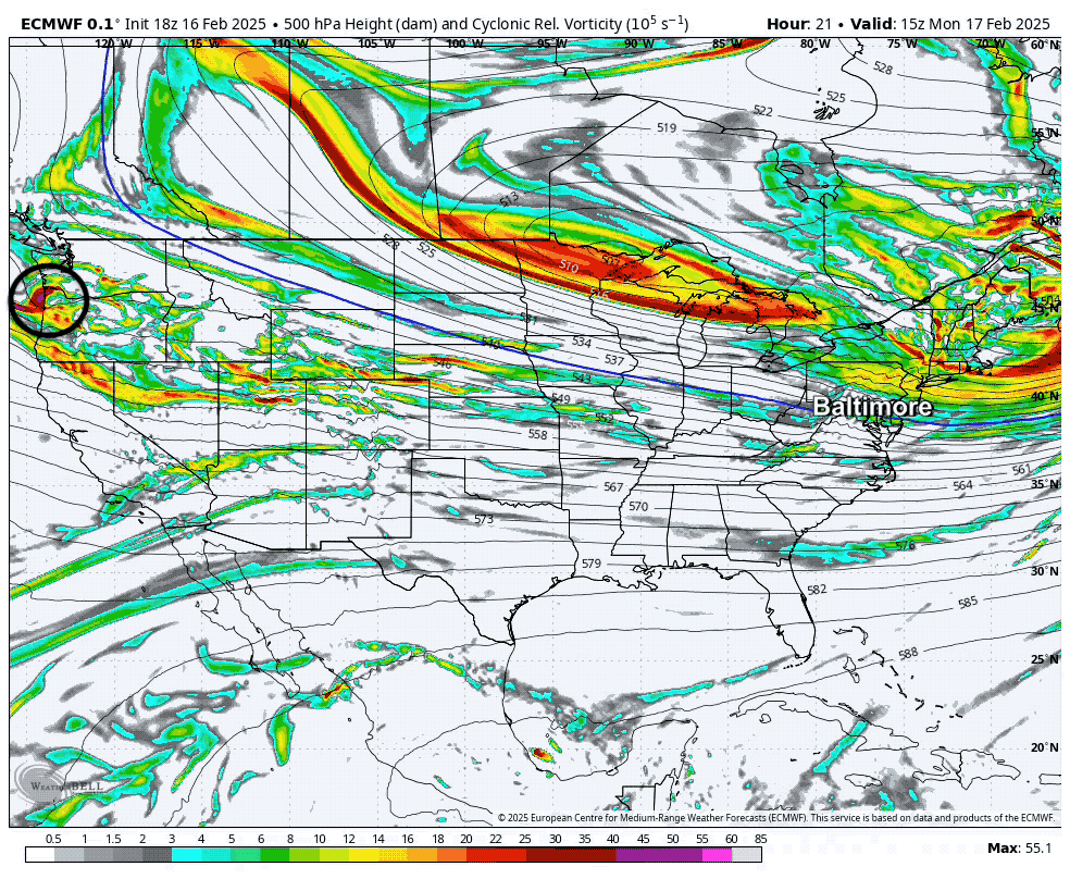
I have seen global computer models lose their way or get a blind spot in a day or two BEFORE the energy reaches the United States. Tomorrow, that will fully enter US air space and be included.
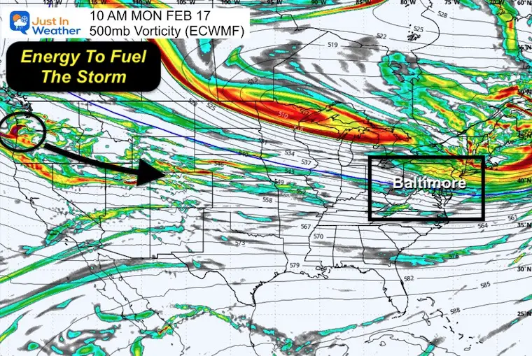
Vorticity Monday Morning
One critical bit of energy for this storm is still over the Pacific Ocean. As seen here, it is expected to reach the Northwest US by Monday morning.
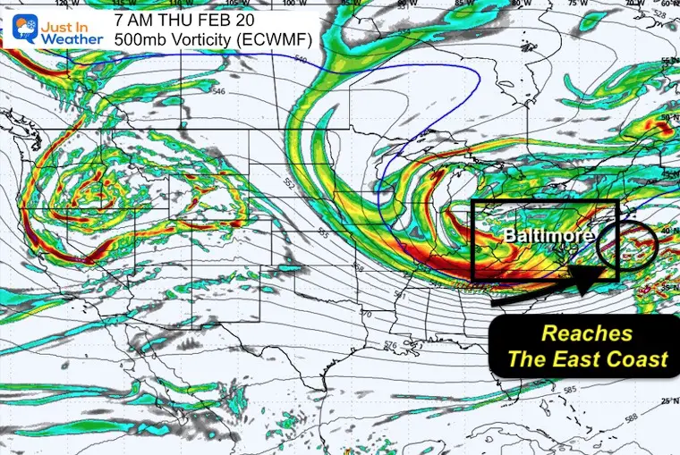
Vorticity Thursday Morning
I have used this time frame as a benchmark for the East Coast Storm to crank in full effect for us. The energy will still be there… We do NOT know exactly where yet.
Animation: Vorticity Monday through Thursday
I marked the Vorticity here. I am sorry it seemed to blurr the image, and I don’t have the time to fix it. I hope this still makes my point.
THE NEW DATA MAY BE BACK ON TRACK OR NOT
We may get some important information with tonight’s new model run, but I expect the full vorticity will be included in tomorrow morning’s model run at 12Z. If there is going to be any shift back closer to the original storm, we may start to see it then. If not, I have no need to wish cast. I will stay on or call this off by then.
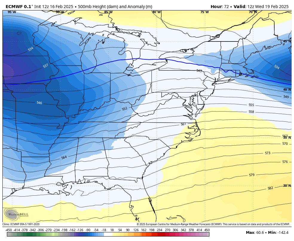
Jet Stream Trough
This is the Northern Branch that will help dig colder air from Canada. In other reports, I’ve shown how this will help invigorate the surface Low to the point of making it turn the corner up the coast into a strong Nor’easter.
This needs to tie out and position itself with the other piece of energy to do that. Timing is key. Also, the strength of this Upper Low and digging trough has trended south in the last two days… playing a role in pushing the full storm south as well and dealing with the full development until after it passes by.

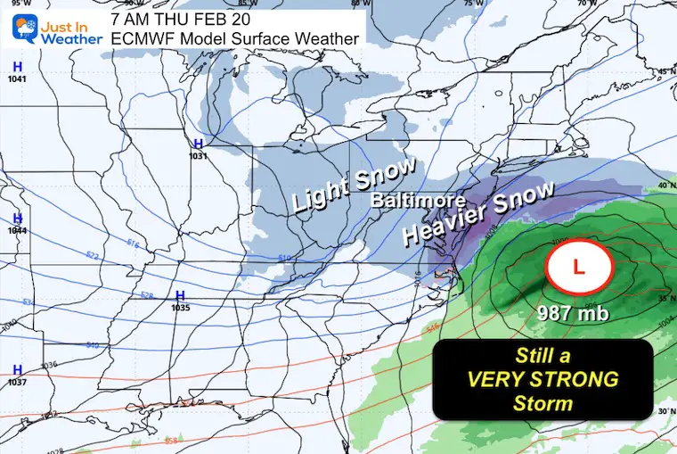
Jet Stream Animation Wednesday To Friday
Storm Animation: Wednesday to Friday
Here the European Model has kept the snow closer to us than the GFS and Canadian. It has been more consistent even while shifting farther south.
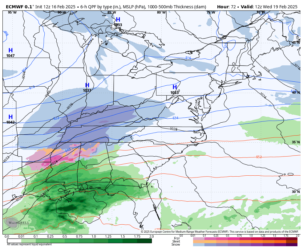
Thursday Morning Snapshot
This looks a lot smaller and farther south with the heavy snow that earlier thought.
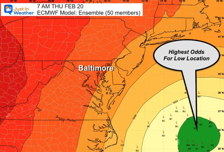
Ensemble Maps
These are products that use 50 members or different scenarios within the same model. It is more responsible for longer range than the deterministic plots we often see… It’s a blend and average of all possibilities.
Thursday Morning Low Locations
The highest odds of where the storm may end up are shown here. We can also see a smattering of other plots farther away and right along the coast.
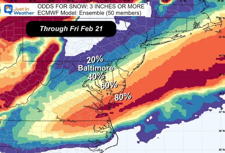
Odds For Snow Of 3 Inches Or More
I intentionally picked this lower marker because it matches up well with the 6 inch odds I showed two days ago. It is still an impact for the same area AND still much lower than the wild maps you may have seen but I DID NOT SHOW. This is why!
How Much Snow Can We Really Expect?
My policy is to show my first call within 72 hours of the event. In that first call I give a low number I have high confidence in, with upside potential.
By Monday afternoon, with the vorticity on the grid, and the models processing it.. I will see if the guidance trends back or not. Then, I will be able to give a forecast that includes a better chance that we all get what we expect.
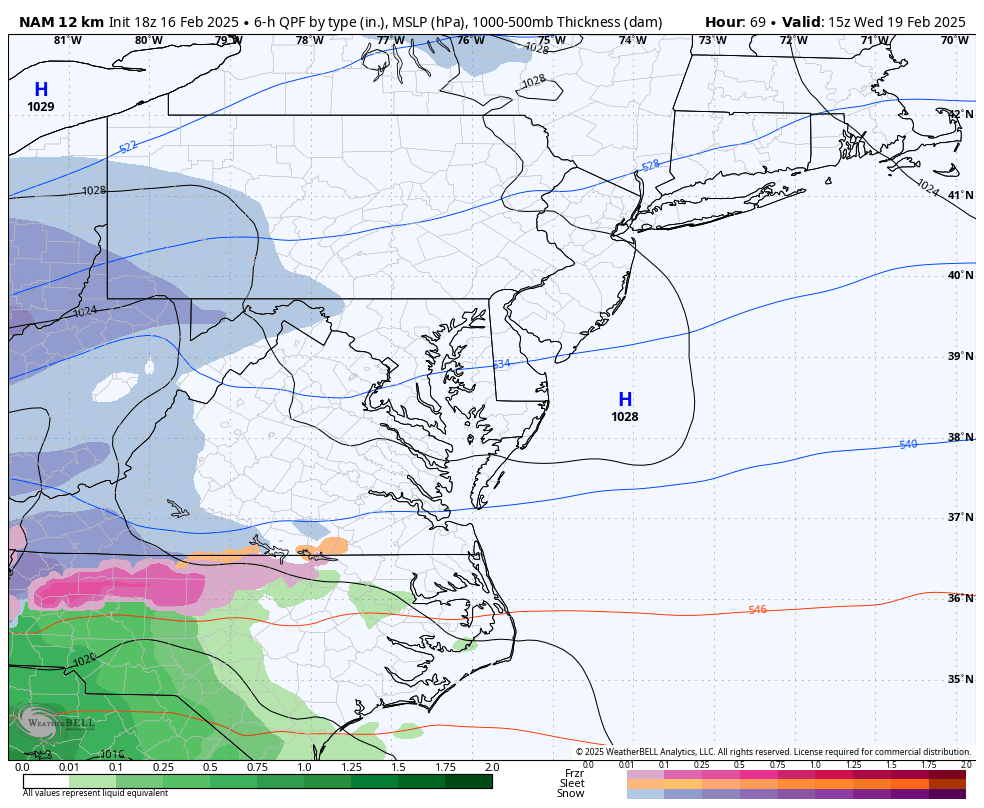
A Nugget Of Hope For Snow Lovers
The NAM 12 Km model is a finer resolution model, but not as tight as its cousin the NAM 3 Km. It does go out farther in time.
This is plotted to the end of the run at 1 AM Thursday…. from this afternoon.
This model has come back north and is now the closest plot of moderate to heavy snow in Central Maryland.
Snapshot at 1 AM Thursday
This is 6 hours earlier than the ECMWF Above… The location is farther north with heavier snow and rapidly intensifying…. to match or surpass the 7 AM intensity the Euro showed.
Take Away
- I do not have a snow forecast yet.
- I am not worried about the recent trend south.
- I do not trust the models have a full handle on the storm and I trust in the fact they are not 100% trustworthy.
- This is why I always write that there is wiggle room.
- I will have a better idea for this storm by midday Monday, and I will share what I see with you.
Faith in the Flakes
Subscribe for eMail Alerts
SNOW REPORTS THIS SEASON
Click on the maps for that full report.
February 11 Snow Report And Grade My Forecast
click here or the map for more

January 19 Snow Report

January 11 Snow Report

January 6 Snow Report

Previous Snow

ALSO SEE
Recent Snow Reports
La Nina Advisory January 2025
Full Report

MY WINTER OUTLOOK
My Winter Outlook Report

FITF Gear on Sale

In Case You Missed This
The Faith In The Flakes Dec 5 Origin Story

Please share your thoughts and best weather pics/videos, or just keep in touch via social media.
SCHEDULE A WEATHER BASED STEM ASSEMBLY
Severe Weather: Storm Smart October and next spring Winter Weather FITF (Faith in the Flakes): November To March Click to see more and send a request for your school.

THANK YOU:
Baltimore Magazine Readers Choice Best Of Baltimore
Maryland Trek 11 Day 7 Completed Sat August 10
We raised OVER $104,000 for Just In Power Kids – AND Still Collecting More
The annual event: Hiking and biking 329 miles in 7 days between The Summit of Wisp to Ocean City.
Each day, we honor a kid and their family’s cancer journey.
Fundraising is for Just In Power Kids: Funding Free Holistic Programs. I never have and never will take a penny. It is all for our nonprofit to operate.
Click here or the image to donate:

RESTATING MY MESSAGE ABOUT DYSLEXIA
I am aware there are some spelling and grammar typos and occasional other glitches. I take responsibility for my mistakes and even the computer glitches I may miss. I have made a few public statements over the years, but if you are new here, you may have missed it: I have dyslexia and found out during my second year at Cornell University. It didn’t stop me from getting my meteorology degree and being the first to get the AMS CBM in the Baltimore/Washington region. One of my professors told me that I had made it that far without knowing and to not let it be a crutch going forward. That was Mark Wysocki, and he was absolutely correct! I do miss my mistakes in my own proofreading. The autocorrect spell check on my computer sometimes does an injustice to make it worse. I also can make mistakes in forecasting. No one is perfect at predicting the future. All of the maps and information are accurate. The ‘wordy’ stuff can get sticky. There has been no editor who can check my work while writing and to have it ready to send out in a newsworthy timeline. Barbara Werner is a member of the web team that helps me maintain this site. She has taken it upon herself to edit typos when she is available. That could be AFTER you read this. I accept this and perhaps proves what you read is really from me… It’s part of my charm. #FITF


