Friday, February 14 2025
The strongest east coast snowstorm of the season has a very good chance to develop for us next week. It is President’s Week, so the odds historically are in our favor anyway. I am going to geek out a little bit on the details in this report so you can see what I am looking at and why it is time to get real. We are approaching the 5-day window, and this is when confidence starts to go up. The language may also get more specific.
A Major Winter Storm would put us in the over 6 inches of snow for a large area.
A Nor’Easter is when we add in strong Northeasterly winds and the location from the Mid-Atlantic to New England (the Northeast US).
A Blizzard is if winds are sustained over 35 mph for 3 hours in addition to snowfall rates at 1 inch per hour over that time. If the pressure levels work out as shown below. The forecast maps include the equivalent of a Category 2 Hurricane off the East Coast next Thursday night.
Bomb Cyclone: When the Pressure level drops more than 24mb in 24 hours. This may do that and reach the equivalent of a Category 1 or 2 hurricane.
I do not take this lightly and wanted to make sure I had enough information before going all in. It is due to a conversation I had on the phone today when I was told about someone’s plans next week and realized that as much lead time as possible might help them adjust to making an earlier flight out of town.
It has not been lost on me that I am writing this on Valentine’s Day, and if you enjoy winter, you may love this snow. I am also well aware that the last storm earlier this worked out about as well as a forecast could verify with timing and totals. So I do not want to mess up a good thing.
We have been in a very active weather pattern and the trend is your friend. We have had some storms show up a week ahead of time and more or less play out. I see this again after a few days with some consistency in the computer model support.
So here is my focus and relying on the physics of the atmosphere to work as expected.
Potential For A Minimum Of 6 inches of Snow
I will NEVER show a range of snow more than three days away! The high-end totals from computer models are often bogus and end up lower.
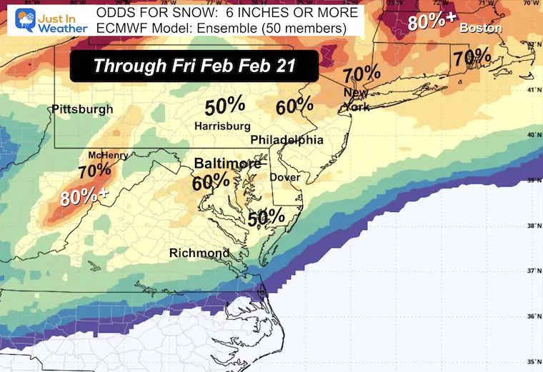
I do not like showing totals this far out, but we have a special occasion. Since many consider a winter storm producing 6 inches of snow or more, let’s start with the reliable European ECWMF Model Ensemble. This model has 50 members or different scenarios/solutions. Based on them, this map is the average ODDS of getting 6 inches or more of snow total by next Friday. The East Coast is focused on this particular storm.
Highlight:
60% Chance for Baltimore and south to include Washington, Annapolis and some of the same areas hit hard time this winter. Most of the region has a 50% chance to get AT LEAST this much snow. Those are high odds for more than 5 days away.
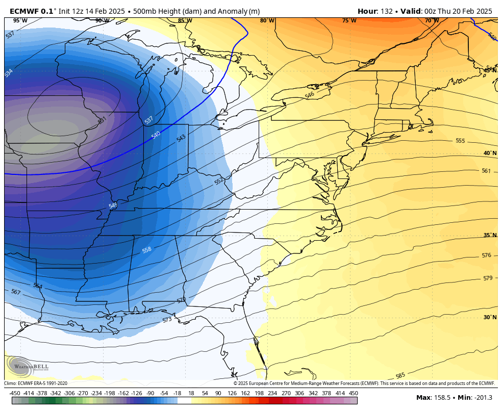
Jet Stream: 500 mb is around 18,000 Ft above the ground
If you want a strong winter storm on the east coast, then the jet steam needs to have favorable conditions.
- Phasing of the Northern and Southern Branches
- Negatively Tilted Trough
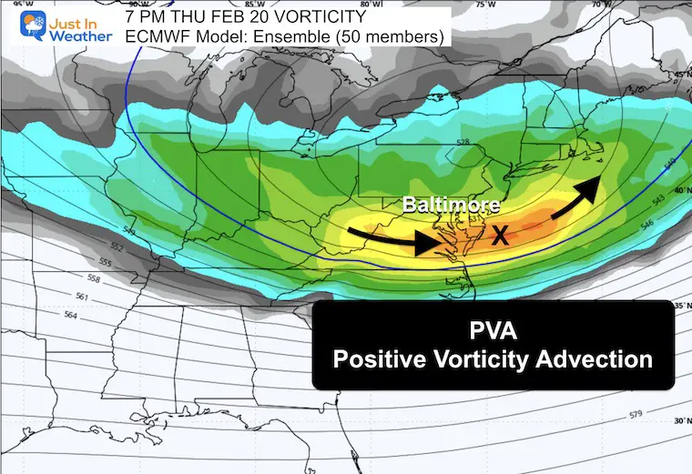
- Positive Vorticity Advection (PVA)
This is a look at the orientation of energy pivoting around the Upper-Level Low. The European Model is swinging a deep trough around the base Thursday morning and tilting Negative, as seen below, in a nearly perfect position towards the Surface Low on the Mid-Atlantic coast.
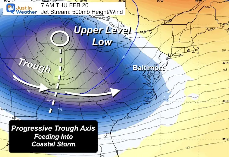
Jet Stream Animation: Wednesday Night to Friday Night
This may help show how this develops and moves through.
Thursday Morning: Progressive Trough
The provides the energy for a surface storm below to move from West to East.
Thursday Night: Negatively Tilted Trough
This orientation helps the storm slow down, gain strength, and move more from the South to the Northeast.
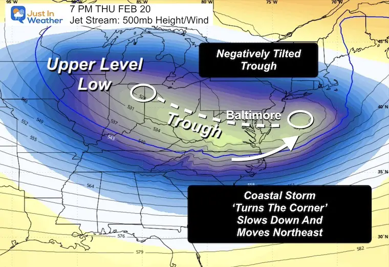
Thursday Night: PVA = Positive Vorticity Advection
This is spin within the Jet Stream that adds energy to the rising and storm development. Here, we see the Vort Max reaching the Mid-Atlantic coast in the location of the Surface Low. See below.
Storm Focus
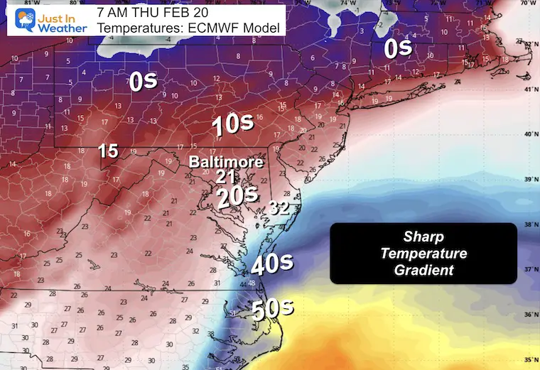
Thursday Morning Temperatures
The polar air that will reach the US next week is expected to get trapped into the storm complex. Here, in the storm’s prime development, we can see a very sharp gradient.
Baltimore = Lower 20s with teens to the north. This would make for a very dry and ‘fluffy’ snow.
To the south, the freezing line is south of Salisbury, MD, and the 50s in coastal North Carolina.
This is nearly ideal for an east coast storm to explode with energy. It feeds off of the contrast of air masses.
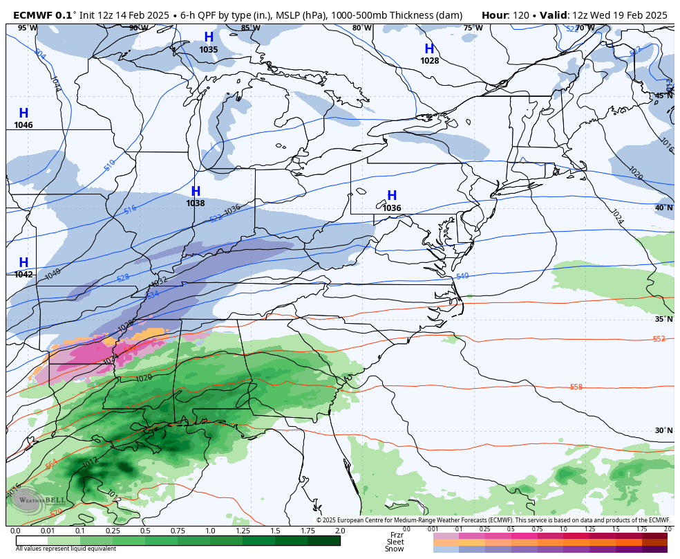
Storm Animation: Wednesday Morning to Friday Morning
Again, this is from the European ECMWF Model. It is the most reliable in this time window.
Given the influence of Polar air, I will start to compare and contrast with the Canadian Model that thrives in this environment.
Snapshots
These are guides, and they are likely to be adjusted as we get closer. They are not perfect, but I will use them to establish consistency or trends with the storm plans.
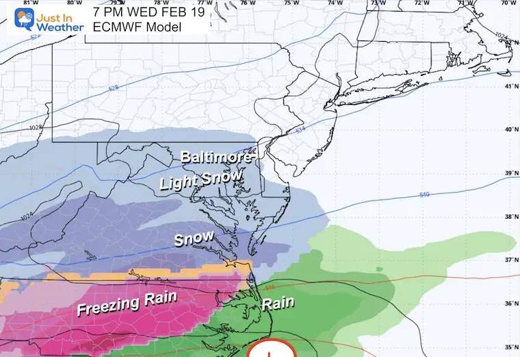
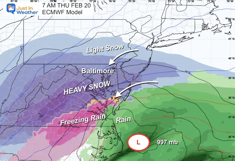
Wednesday Night
Light snow may enter our area, but the initial hit will be to our south at this time.
Thursday Morning
This is when all the upper-level energy lines up, and the coastal storm takes form. It will spread moderate to heavy snow northward.
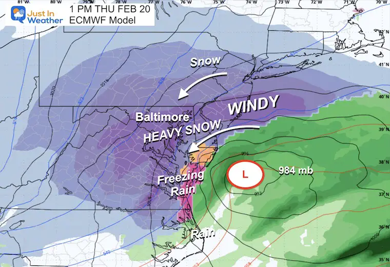
Thursday Afternoon: Full Force
Note the air pressure at 984 mb. This would be equivalent to a Category 1 Hurricane.
Strong winds and possible Blizzard Conditions may enter into conversation during the day.
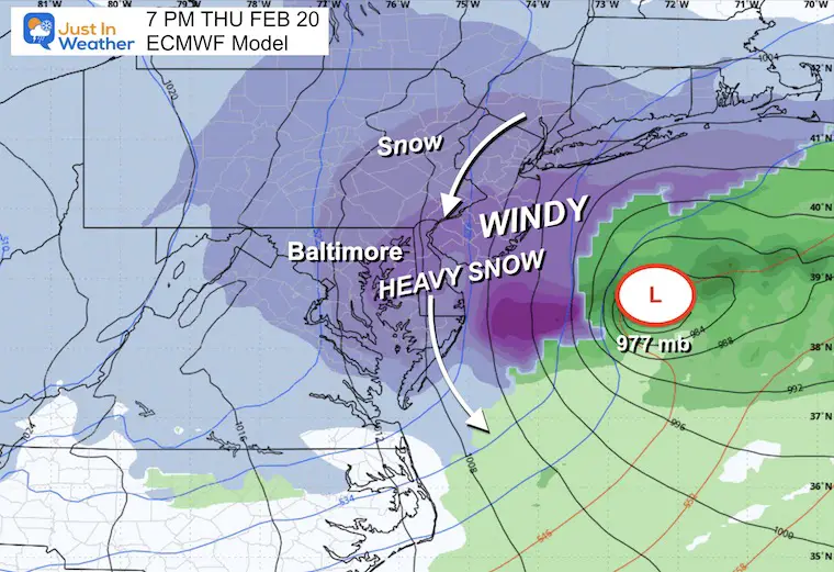
Thursday Night: Full Force
Note the air pressure at 977 mb. This would be in the weak Category 2 Hurricane range. Powerful Nor’easters have been called winter hurricanes. Winds can be over 75 with 50FT waves in the ocean and blizzard conditions in the snow zone inland.
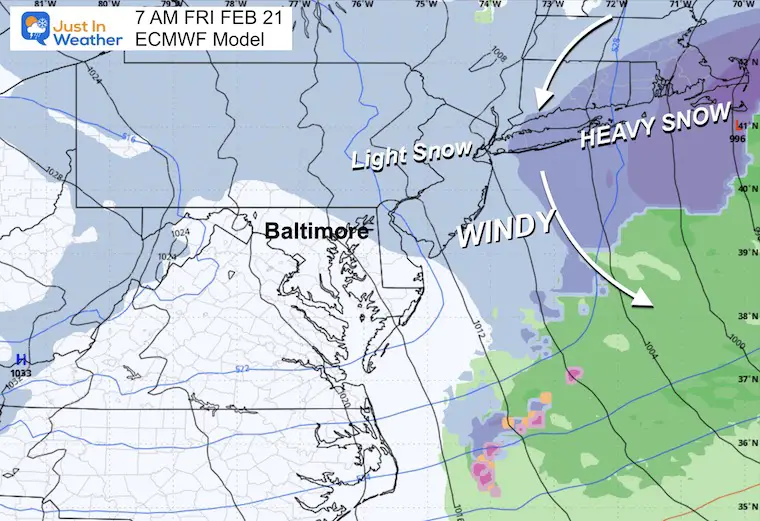
Friday Morning
The storm is expected to lift away, but a large area of light snow and snow showers may linger well behind the low for 12 to 24 hours.
How Much Snow?
No one knows, and I personally do not agree with showing the model plots. There can be a wide range, and it’s easy to show the biggest numbers for a lot of clicks. I will not play into that and do not want to have to pull back as we get closer. I would rather my first call for snowfall be close to what we get.
While I showed the 6-inch plus odds, this does have the potential to drop over 12 inches, especially considering the cold temperatures and ‘fluff’ factor.
With the wind, blowing and drifting snow will be a factor as well.
Take Away
- This storm may start to show on Wednesday night.
- Thursday is most likely the STORM DAY
- Friday will be the clean-up day.
- This will be the biggest storm in years!
Faith in the Flakes.
Subscribe for eMail Alerts
La Nina Advisory January 2025
Full Report

MY WINTER OUTLOOK
My Winter Outlook Report

ALSO SEE
Recent Snow Reports
SNOW REPORTS THIS SEASON
Click on the maps for that full report.
February 11 Snow Report And Grade My Forecast
click here or the map for more

January 19 Snow Report

January 11 Snow Report

January 6 Snow Report

Previous Snow

FITF Gear on Sale

In Case You Missed This
The Faith In The Flakes Dec 5 Origin Story

Please share your thoughts and best weather pics/videos, or just keep in touch via social media.
SCHEDULE A WEATHER BASED STEM ASSEMBLY
Severe Weather: Storm Smart October and next spring Winter Weather FITF (Faith in the Flakes): November To March Click to see more and send a request for your school.

THANK YOU:
Baltimore Magazine Readers Choice Best Of Baltimore
Maryland Trek 11 Day 7 Completed Sat August 10
We raised OVER $104,000 for Just In Power Kids – AND Still Collecting More
The annual event: Hiking and biking 329 miles in 7 days between The Summit of Wisp to Ocean City.
Each day, we honor a kid and their family’s cancer journey.
Fundraising is for Just In Power Kids: Funding Free Holistic Programs. I never have and never will take a penny. It is all for our nonprofit to operate.
Click here or the image to donate:

RESTATING MY MESSAGE ABOUT DYSLEXIA
I am aware there are some spelling and grammar typos and occasional other glitches. I take responsibility for my mistakes and even the computer glitches I may miss. I have made a few public statements over the years, but if you are new here, you may have missed it: I have dyslexia and found out during my second year at Cornell University. It didn’t stop me from getting my meteorology degree and being the first to get the AMS CBM in the Baltimore/Washington region. One of my professors told me that I had made it that far without knowing and to not let it be a crutch going forward. That was Mark Wysocki, and he was absolutely correct! I do miss my mistakes in my own proofreading. The autocorrect spell check on my computer sometimes does an injustice to make it worse. I also can make mistakes in forecasting. No one is perfect at predicting the future. All of the maps and information are accurate. The ‘wordy’ stuff can get sticky. There has been no editor who can check my work while writing and to have it ready to send out in a newsworthy timeline. Barbara Werner is a member of the web team that helps me maintain this site. She has taken it upon herself to edit typos when she is available. That could be AFTER you read this. I accept this and perhaps proves what you read is really from me… It’s part of my charm. #FITF


