February 14 2025
Friday Morning Report
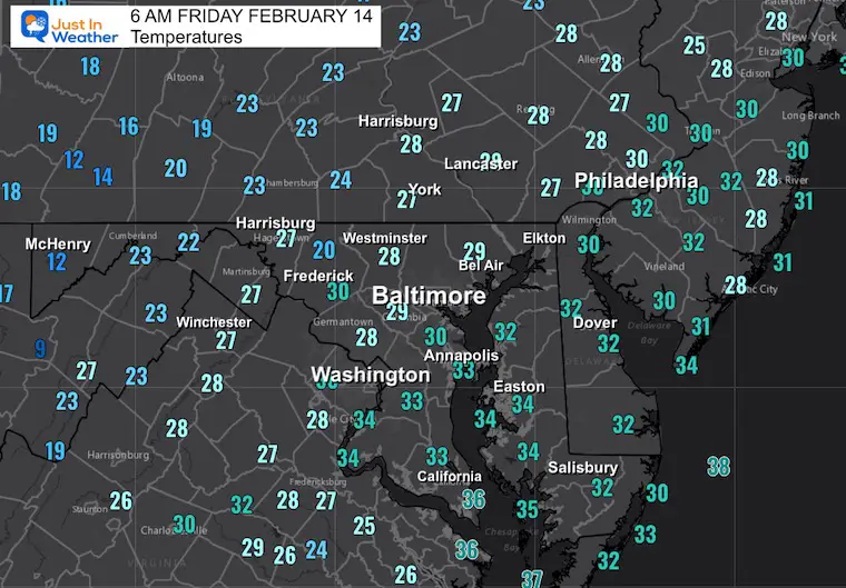
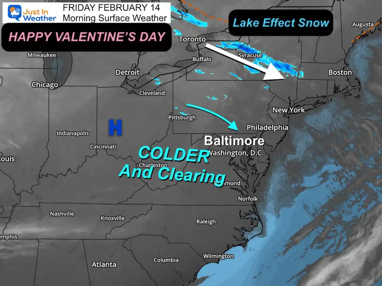
The strong winds yesterday helped to bring back colder air this morning. You may love the sunshine on this Valentine’s Day. Enjoy the break. Our active weather continues with the next system arriving midday Saturday.
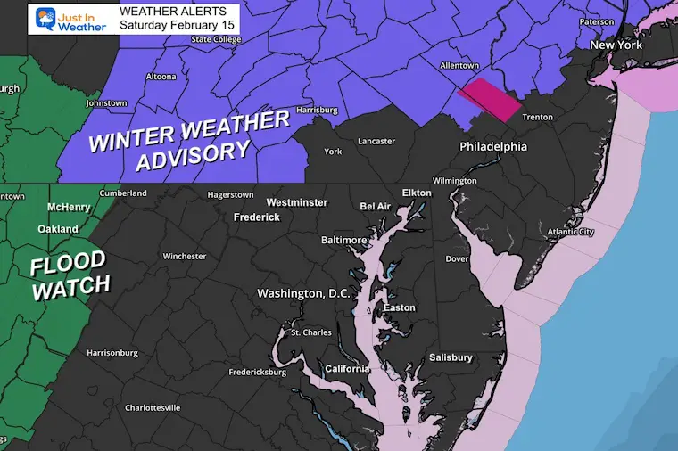
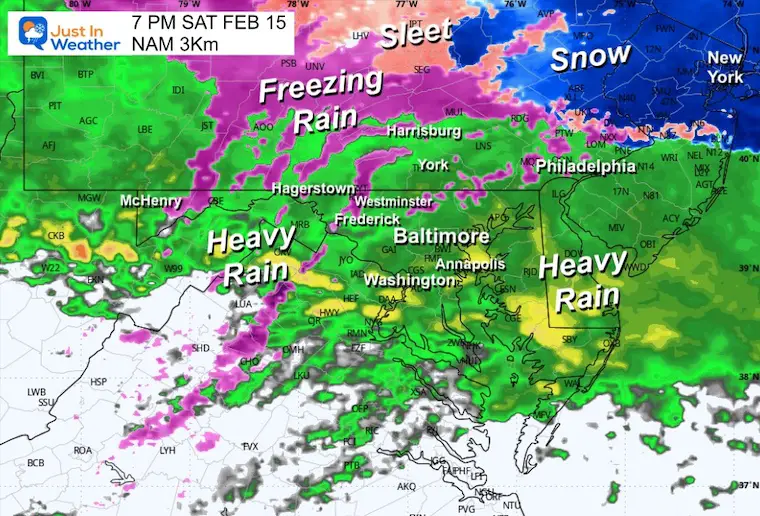
At this time, our mix should not impact roads in metro areas, but farther inland, travel may become slick. This includes a Winter Weather Advisory for parts of Southern Pennsylvania.
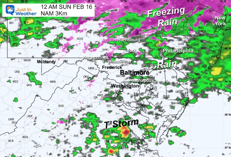
The mix of snow, sleet, and freezing rain will turn to rain as warmer air arrives Saturday night and Sunday. Then strong winds will bring back more cold.
The active pattern continues:
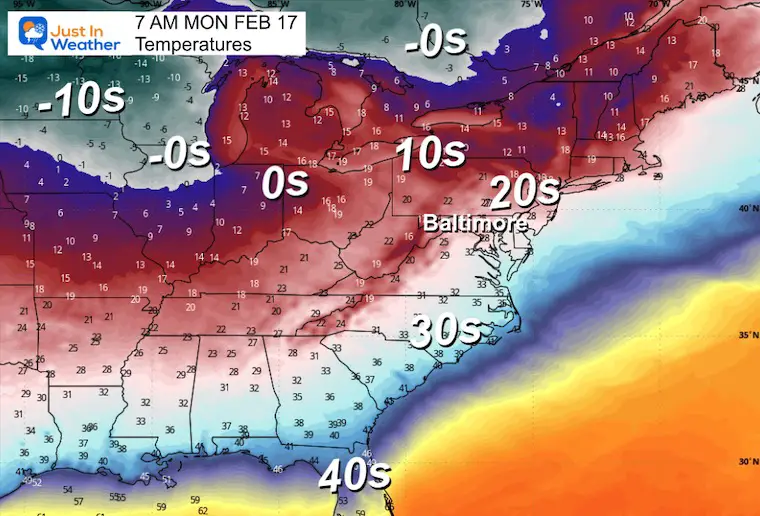
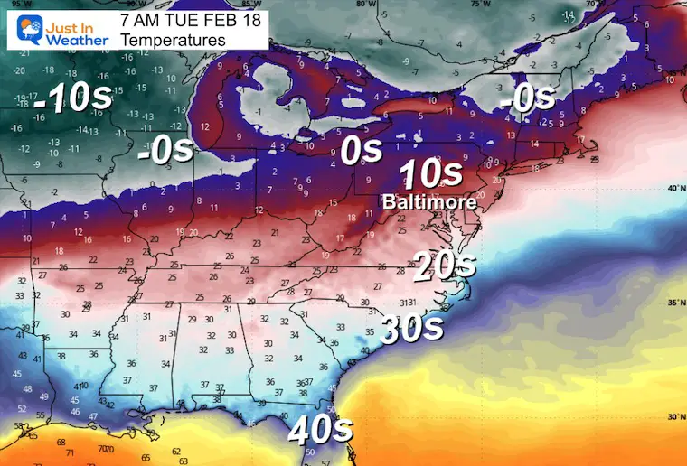
Monday and Tuesday: Return of Polar Air
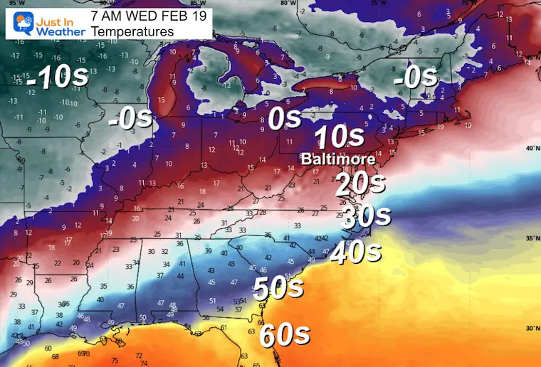
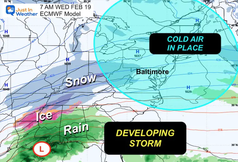
Wednesday to Thursday: The next winter storm looks like it will become a strong one and moderate to heavy snow maker. More details and I’ve picked my model to focus on… including the odds of getting 6 inches of snow or more.
CLIMATE DATA: Baltimore
TODAY February 14
Sunrise at 6:59 AM
Sunset at 5:43 PM
Normal Low in Baltimore: 27ºF
Record -2F in 1979
Normal High in Baltimore: 46ºF
Record 70ºF 1990
Baltimore Seasonal Snow
12.7” – Very Close To Average
DROUGHT UPDATE
Rainfall Deficit at BWI
Ending 2024 = -8.00″, since Jan 1 = -1.57
So we are down -9.57″, including last year!
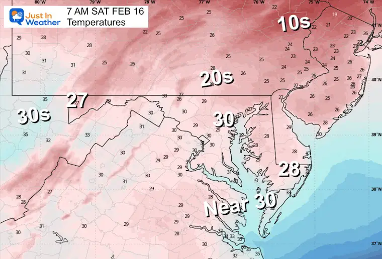
Morning Temperatures
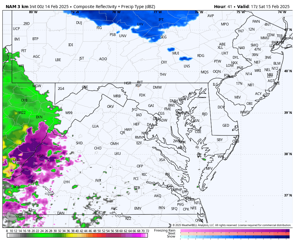
Morning Surface Weather
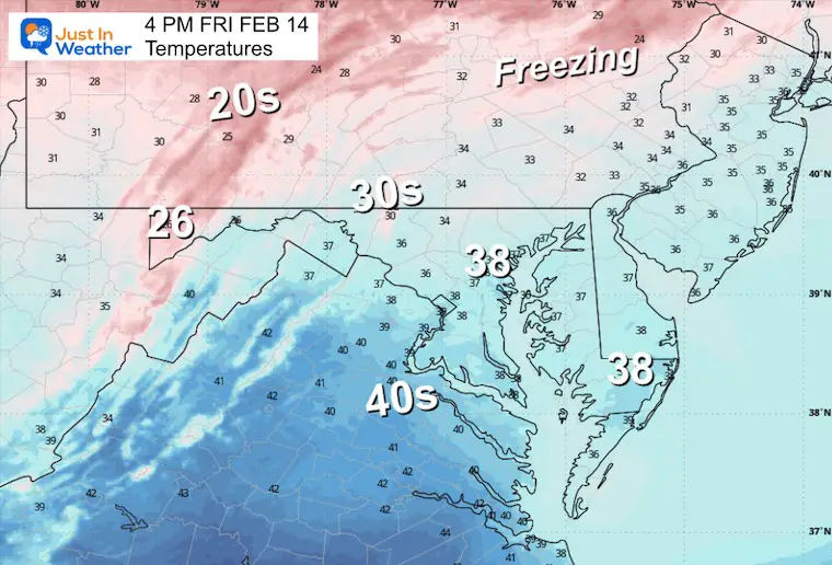
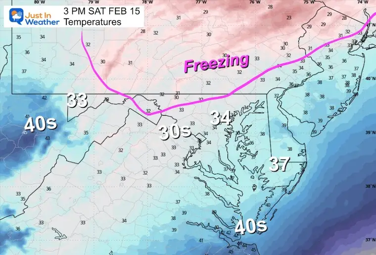
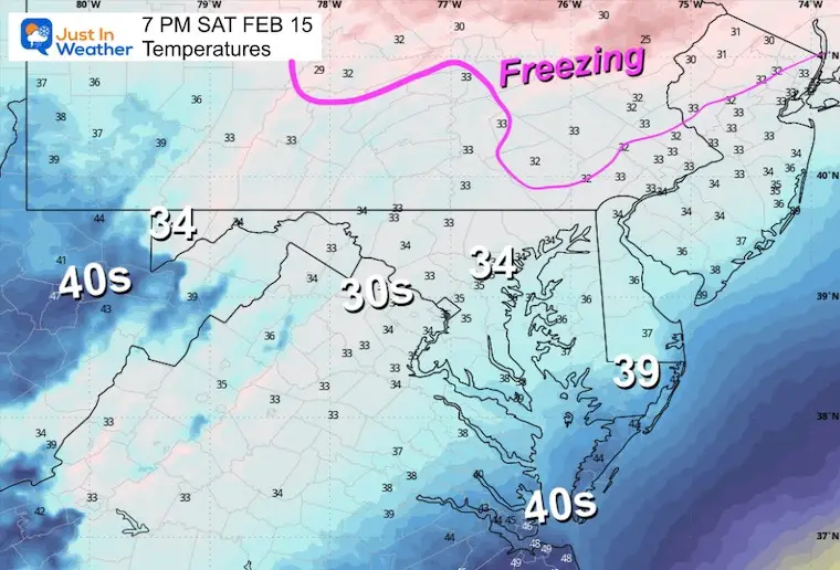
Afternoon Temperatures
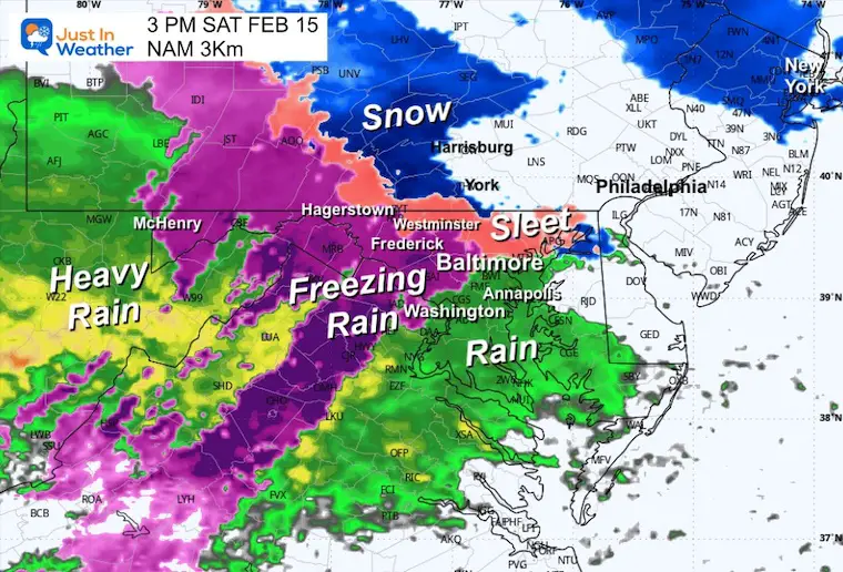
SATURDAY WEATHER
This is looking like a wintry mix develops mid-day to early afternoon…
Most roads stay wet… but become a problem farther inland. Reminder: the current Winter Weather Advisory is only posted for parts of Southern Pennsylvania.
Winter Weather Advisory
Saturday Morning Temperatures
Radar Simulation Noon to Midnight
3 PM Snapshot
7 PM Snapshot
Midnight
Sunday
Warmer and drying out. Then strong winds will arrive later to usher in the colder air.
Polar Air Early Next Week
The influence of the Polar Vortex will send deep arctic air into the US: Well Below Zero across the Northern Plains.
The arrival into our region may be a little later… This may play a role in the next storm next week.
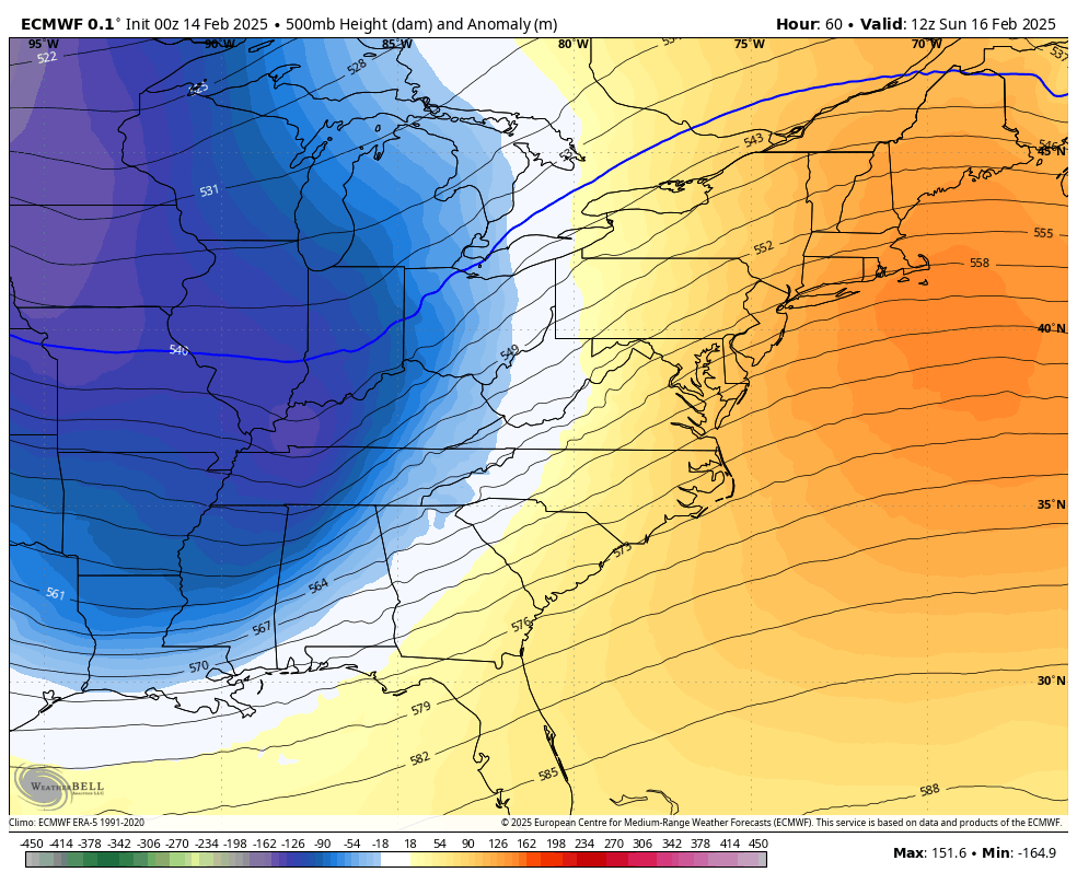
Jet Stream Forecast Sunday to Friday
Monday Morning
Tuesday Morning
Wednesday Morning
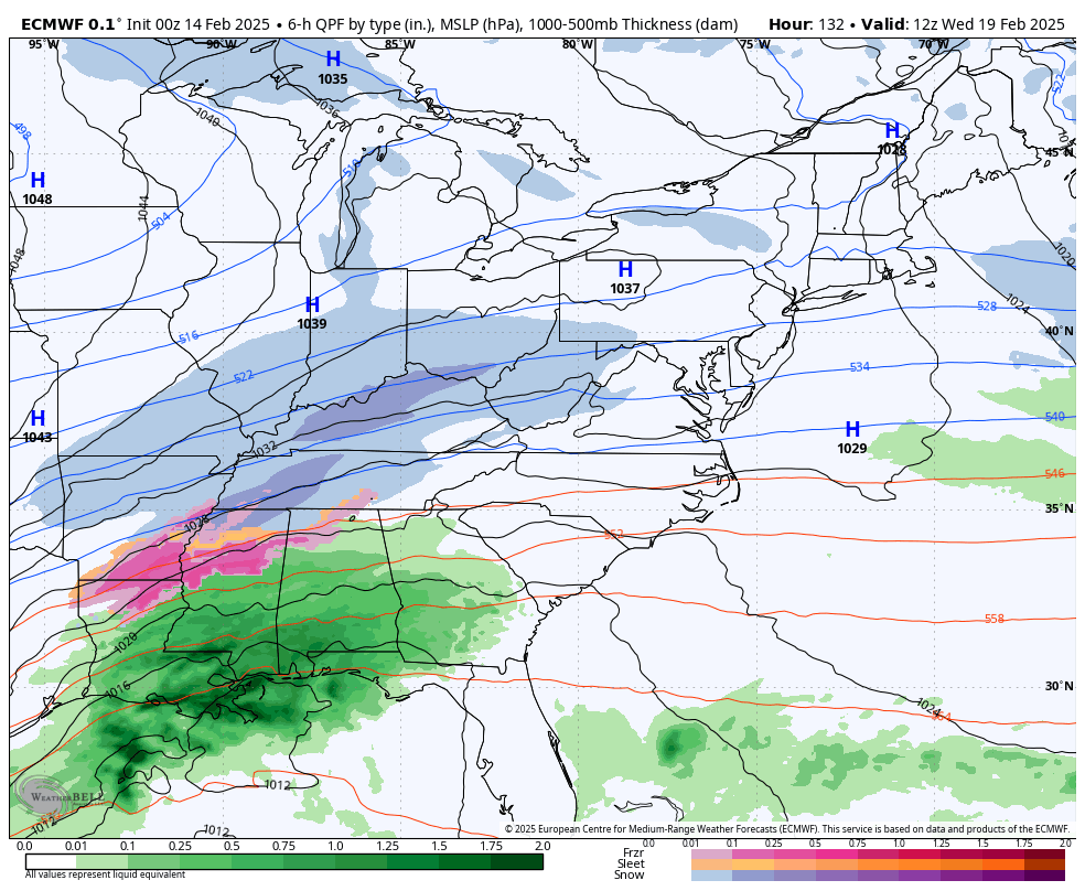
Next Week Storm?
With polar air in place, the next wave in the jet stream will be strong and try to rapidly develop off the Mid-Atlantic coast.
Here is the European Solution. This model gets the edge farther out in time.
Set Up Wednesday Morning
A large dome of cold air is in place, while a classic storm along the Gulf Coast will be forming. Low Pressure near New Orleans is a good position to start from as it heads toward the Mid-Atlantic Coast.
Forecast Simulation: Wednesday Morning to Friday Morning
Snapshots
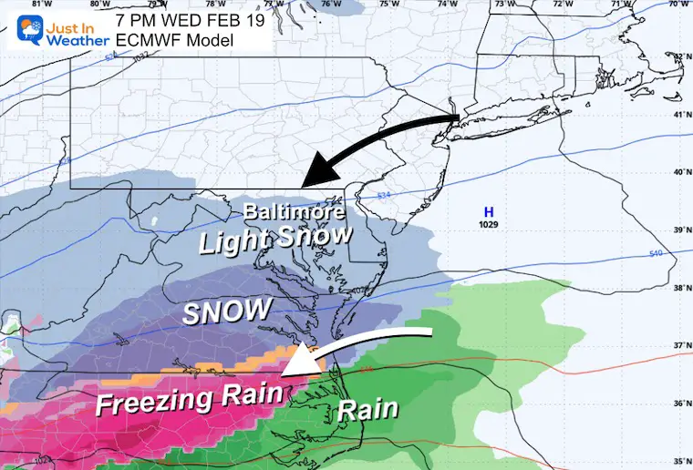
Wednesday Night
Snow will be arriving from the South and light snow may break out into Central Maryland to begin the storm.
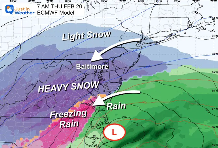
Thursday Morning
Low Pressure moves off the North Carolina coast and a lock of cold and snow across much of Maryland.
(The specifics are subject to some change)
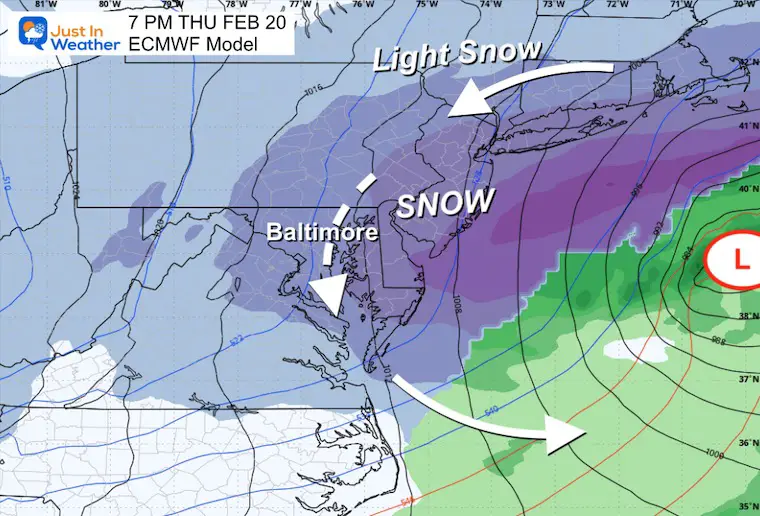
Thursday Night
Storm Track moves east off the coast and the steady snow will be winding down.
At this time, it looks like an all-day event.
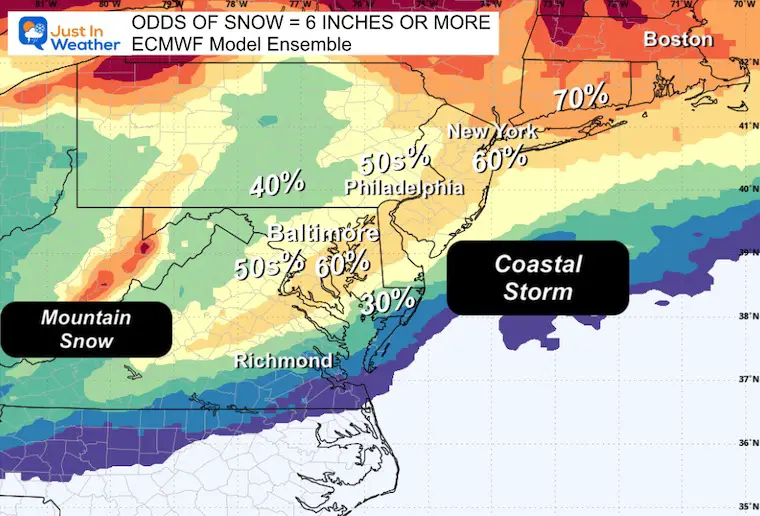
Snow Potential
I DO NOT like to give snow totals more than 3 days away. However, with such a large event, I want to show you a deeper dive into the 50 member Ensemble of the European Model. Here are the odds of getting 6 inches or more, as seen now. This is also subject to adjustment and change as the track gets refined.
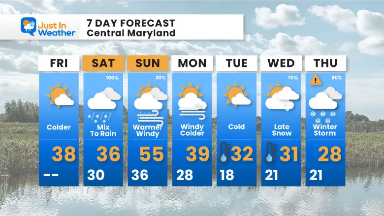
7 Day Forecast
Saturday Mix to rain, Travel Issue In PA
Polar Air arrives on Monday
Winter Storm Potential: Wednesday and Thursday
Subscribe for eMail Alerts
La Nina Advisory January 2025
Full Report

MY WINTER OUTLOOK
My Winter Outlook Report

ALSO SEE
Recent Snow Reports
SNOW REPORTS THIS SEASON
Click on the maps for that full report.
February 11 Snow Report And Grade My Forecast
click here or the map for more

January 19 Snow Report

January 11 Snow Report

January 6 Snow Report

Previous Snow

FITF Gear on Sale

In Case You Missed This
The Faith In The Flakes Dec 5 Origin Story

Please share your thoughts and best weather pics/videos, or just keep in touch via social media.
SCHEDULE A WEATHER BASED STEM ASSEMBLY
Severe Weather: Storm Smart October and next spring Winter Weather FITF (Faith in the Flakes): November To March Click to see more and send a request for your school.

THANK YOU:
Baltimore Magazine Readers Choice Best Of Baltimore
Maryland Trek 11 Day 7 Completed Sat August 10
We raised OVER $104,000 for Just In Power Kids – AND Still Collecting More
The annual event: Hiking and biking 329 miles in 7 days between The Summit of Wisp to Ocean City.
Each day, we honor a kid and their family’s cancer journey.
Fundraising is for Just In Power Kids: Funding Free Holistic Programs. I never have and never will take a penny. It is all for our nonprofit to operate.
Click here or the image to donate:

RESTATING MY MESSAGE ABOUT DYSLEXIA
I am aware there are some spelling and grammar typos and occasional other glitches. I take responsibility for my mistakes and even the computer glitches I may miss. I have made a few public statements over the years, but if you are new here, you may have missed it: I have dyslexia and found out during my second year at Cornell University. It didn’t stop me from getting my meteorology degree and being the first to get the AMS CBM in the Baltimore/Washington region. One of my professors told me that I had made it that far without knowing and to not let it be a crutch going forward. That was Mark Wysocki, and he was absolutely correct! I do miss my mistakes in my own proofreading. The autocorrect spell check on my computer sometimes does an injustice to make it worse. I also can make mistakes in forecasting. No one is perfect at predicting the future. All of the maps and information are accurate. The ‘wordy’ stuff can get sticky. There has been no editor who can check my work while writing and to have it ready to send out in a newsworthy timeline. Barbara Werner is a member of the web team that helps me maintain this site. She has taken it upon herself to edit typos when she is available. That could be AFTER you read this. I accept this and perhaps proves what you read is really from me… It’s part of my charm. #FITF


