Thursday Night, February 13 2025
In the winter that keeps on giving, this storm pattern is dizzying and continues to serve up a few more weather events. The strong winds today are the leading edge of colder air returning. It is looking like that cold air will hold as the next storm arrives this weekend. The focus will be on midday Saturday for snow, sleet, and freezing rain, eventually trending to rain at night into Sunday.
The sun angle is more of a factor from mid-February on… The solar radiation helps the pavement stay warm enough to counter stickage. I believe most roads in metro areas will stay wet until 4 or 5 PM, but inland areas with higher elevations of 500 to 1000 feet will have the chance to slick roads.
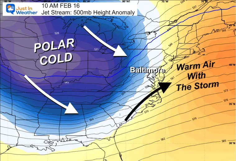
The ‘influence’ of the Polar Vortex will arrive next week. That will invigorate another wave along the jet stream that is expected to produce yet another southern track snowstorm. With that farther out in time, there is lower confidence in the specifics. But the physics of the atmosphere will produce the energy.
Let’s start with the short range:
Saturday Morning Set-Up
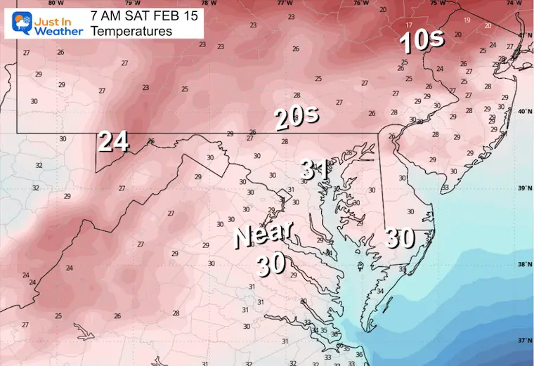
Temperatures at 7 AM
A broad brush across the region in the upper 20s to lower 30s to start the day.
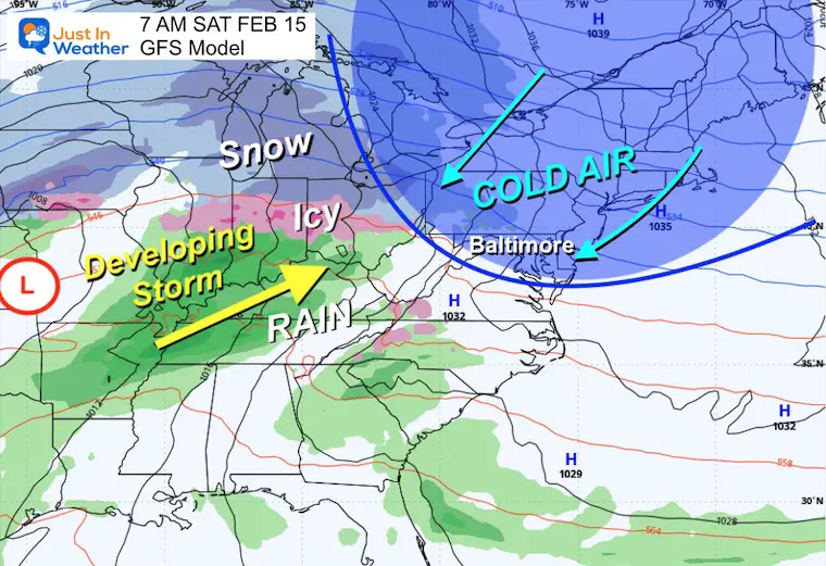
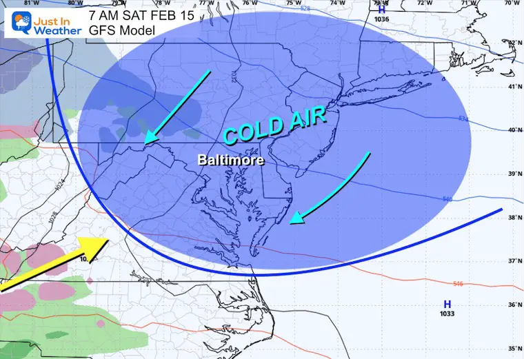
Surface Weather at 7 AM
I’ve marked the intrusion of the cold air under the influence of High Pressure in Eastern Canada.
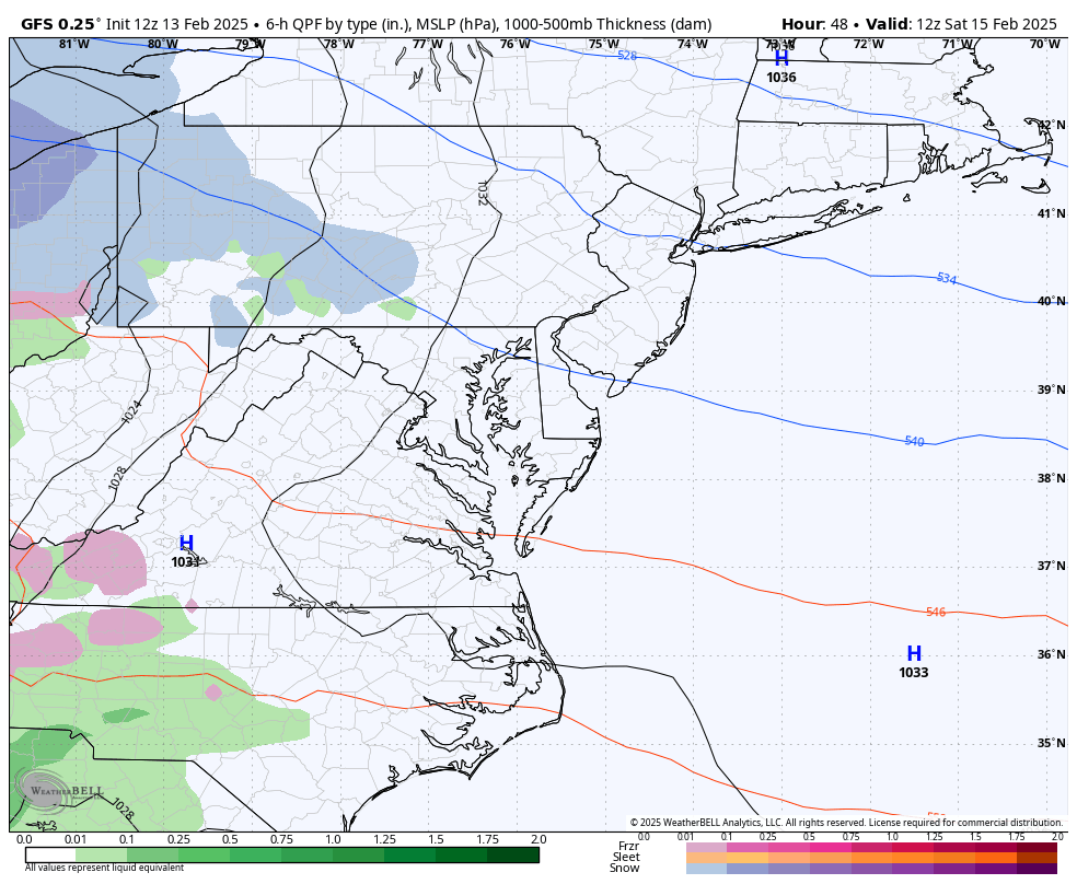
If this storm pattern looks familiar, it should. It’s a set-up we’ve seen a few times this winter. The storm in the Central US will send moisture our way that will run up and over the cold air in place. This is expected to develop late morning into early afternoon across the Mid-Atlantic.
Storm Animation: 7 AM Sat to 7 PM Sun
Initially snow, then sleet will spread with rain advancing faster from the south.
An extended period of freezing rain will inland in the colder inland areas Saturday night. But the storm track will push warmer air and rain across the region, so Sunday morning will be just wet!
Closer View
Surface Weather at 7 AM
The timing of the precipitation is critical. The earlier it starts it will hold the cold in place. If it is delayed a few hours, the warmer air and rain have a chance to advance.
Storm Animation: 7 AM Sat to 7 PM Sun
Snapshots
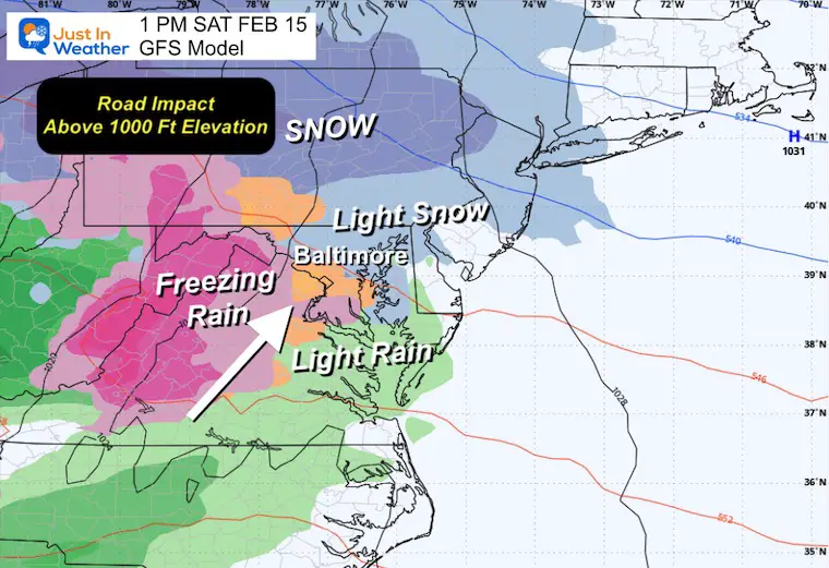
1 PM Saturday
Light snow and sleet may be falling, but the pavement in most metro areas should stay wet. The higher elevations from 500 Ft to 1000+ Ft are where we will start to see some stickage when this gets heavier.
Ironically, this may be where freezing rain will become more prominent as the layer of cold air gets very shallow.
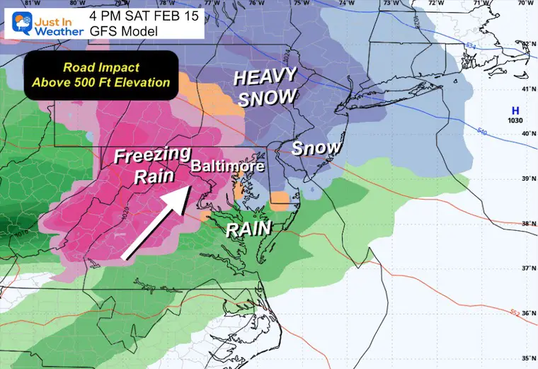
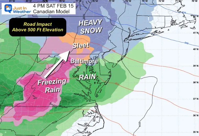
4 PM Saturday
Freezing rain is more likely to take over later in the day. The issue will remain for the inland colder areas, where an extended period of icing may take place through the evening and night.
This may produce 1 to 2 inches of snow in the colder zones near the MD and PA line, with more substantial snow towards the Poconos of Northeast PA.
Other Models
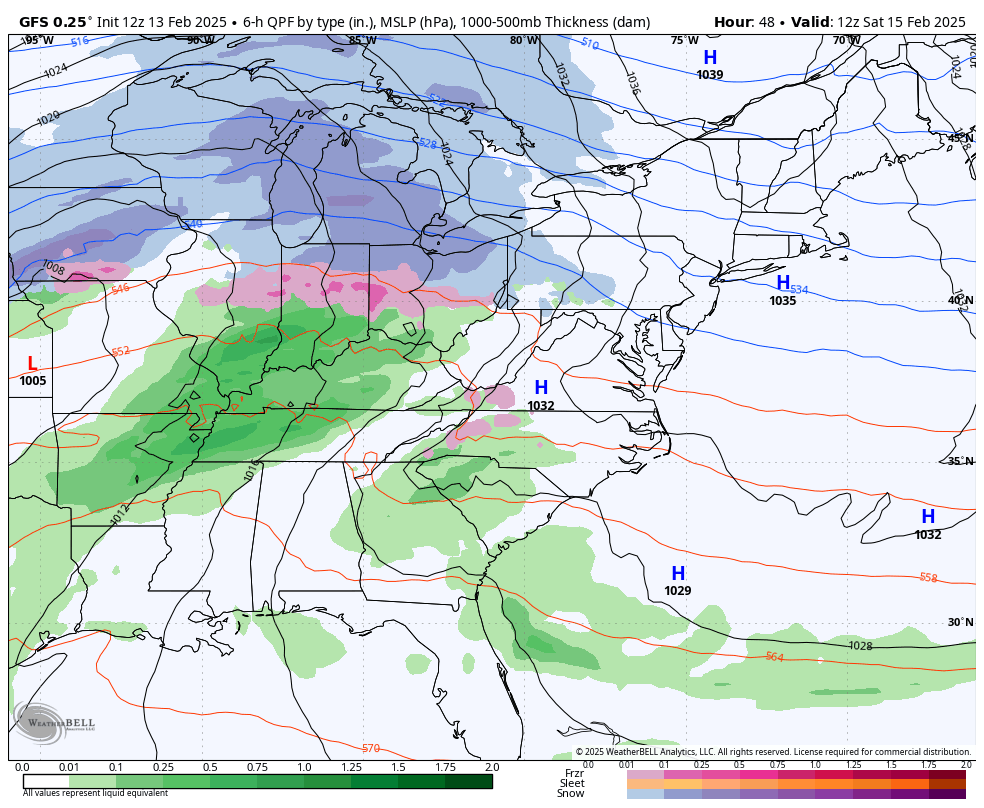
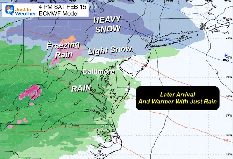
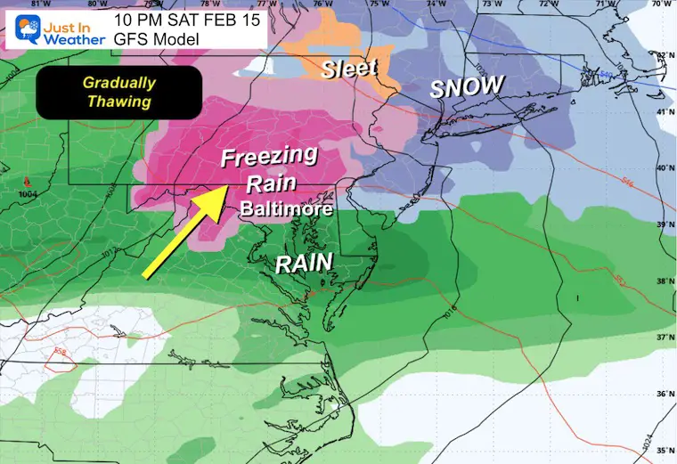
You may have noticed I chose the GFS Model to show here. That is because it led the way for this mixed event and has support.
The European ECMWF Model is the outlier because it delays the start of the precipitation. That allows the temperatures to warm before it arrives in the afternoon… resulting in more rain for most of us, and the snow/mix gets pushed north.
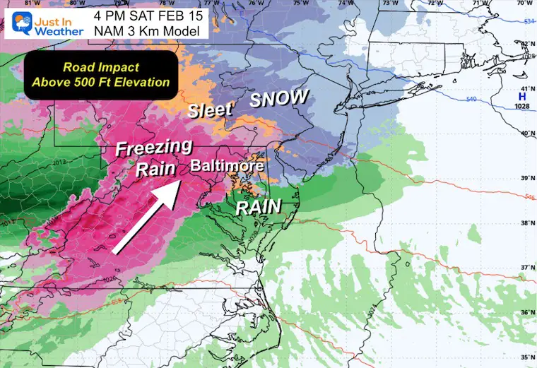
NAM 3Km
Canadian Model
European Model
This is the outlier. It is warmer because it holds the precipitation off until later.. allowing temps to modify. This still brings light snow to start along The PA Turnpike and north.
Saturday Night
I do think the GFS is too cold, so the thaw may occur a couple of hours earlier than this.
Assuming the colder solution is correct, then we will watch the gradual change over to rain from south to north. This may linger around metro Baltimore into the dark hours, but should be done by midnight. That thaw line will continue to get pushed north with warmer winds.
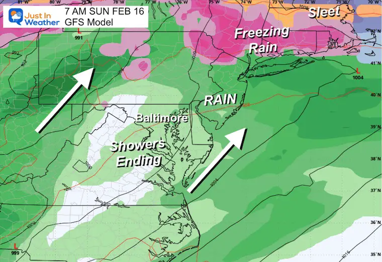
Sunday Morning
Got plans for church or something else? They should be OK. Temps will push into the 50s again in the afternoon…. Just before the next wind event and leading edge of the arctic air.
Polar Vortex Influence: Jet Stream Sunday
The actual Polar Vortex is not going to reach the United States, but it will seem like it. The cold air mass will expand our way for a few days and feed into the next storm.
NOAA Temperature Outlook
Temperatures
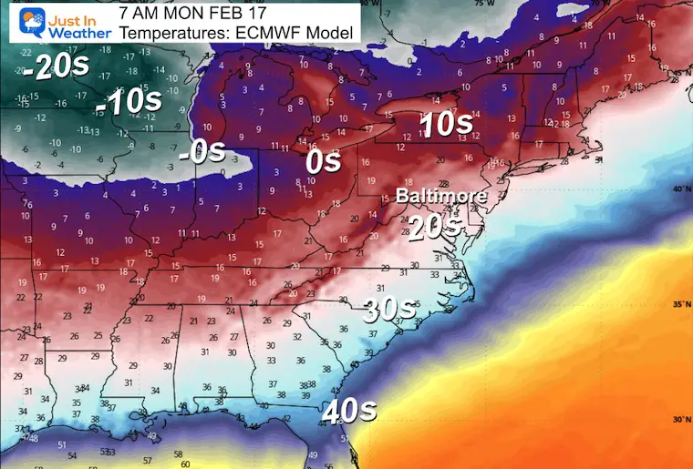
Monday Morning
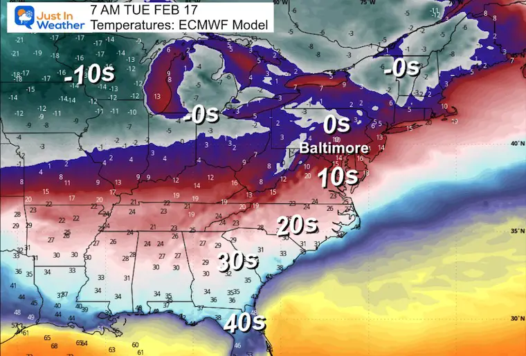
Tuesday Morning
Winter Storm Next Week?
I have been hinting at this because I believe the physics will produce a storm along the Arctic boundary.
I DO NOT have confidence in the specifics. We are still about 1 week away, and there will be adjustments as we get closer. That is why I do not like to show snow totals…. Although I did post on social media earlier the model product with the odds of getting 6 or more to be south of Baltimore AGAIN!
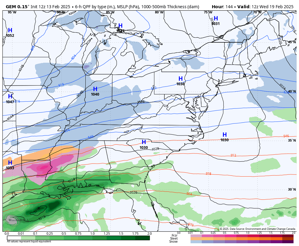
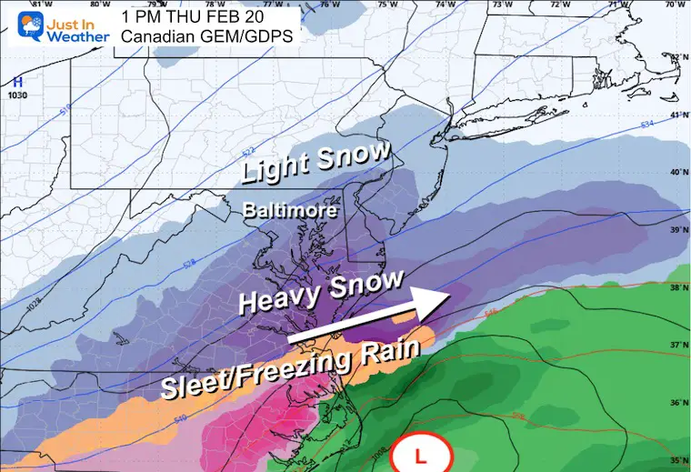
Since we will be in an Arctic-dominated pattern, I tend to lean on the Canadian Model because this is where it thrives. Here is how it sees the storm develop between Wednesday and Thursday.
Snapshots
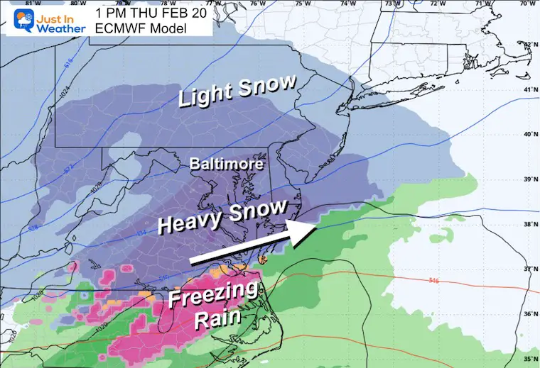
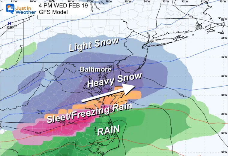
The Canadian and European models have this as a Thursday storm. It digs south and redevelops to try and cut a little up the coast—it is NOT a pure Nor’easter. The GFS, on the other hand, has this arriving a day earlier… on Wednesday. It takes the energy on the boundary directly across the US with no delay.
Here are the model Guidance SUGGESTIONS. This is NOT how I expect the final results to display. It is a guide for any trend as we get closer.
Canadian: Thursday Afternoon
ECMWF Model: Thursday Afternoon
GFS Model: EARLIER on Wednesday Afternoon
Take Away:
The active pattern will continue.
- Saturday brings a winter mix to end as rain overnight and Sunday.
- Sunday will be warmer and turn windy
- Monday and Tuesday will be much colder
- Wednesday to Thursday we WATCH for the potential snow event. I believe in our region, getting 6 inches or more of snow will qualify as a storm. This has the potential to do that… but NOT FOR EVERYONE.
Stay tuned… The reach of the polar air will determine the setup for the storm track.
Faith in the Flakes
Subscribe for eMail Alerts
La Nina Advisory January 2025
Full Report

MY WINTER OUTLOOK
My Winter Outlook Report

ALSO SEE
Recent Snow Reports
SNOW REPORTS THIS SEASON
Click on the maps for that full report.
February 11 Snow Report And Grade My Forecast
click here or the map for more

January 19 Snow Report

January 11 Snow Report

January 6 Snow Report

Previous Snow

FITF Gear on Sale

In Case You Missed This
The Faith In The Flakes Dec 5 Origin Story

Please share your thoughts and best weather pics/videos, or just keep in touch via social media.
SCHEDULE A WEATHER BASED STEM ASSEMBLY
Severe Weather: Storm Smart October and next spring Winter Weather FITF (Faith in the Flakes): November To March Click to see more and send a request for your school.

THANK YOU:
Baltimore Magazine Readers Choice Best Of Baltimore
Maryland Trek 11 Day 7 Completed Sat August 10
We raised OVER $104,000 for Just In Power Kids – AND Still Collecting More
The annual event: Hiking and biking 329 miles in 7 days between The Summit of Wisp to Ocean City.
Each day, we honor a kid and their family’s cancer journey.
Fundraising is for Just In Power Kids: Funding Free Holistic Programs. I never have and never will take a penny. It is all for our nonprofit to operate.
Click here or the image to donate:

RESTATING MY MESSAGE ABOUT DYSLEXIA
I am aware there are some spelling and grammar typos and occasional other glitches. I take responsibility for my mistakes and even the computer glitches I may miss. I have made a few public statements over the years, but if you are new here, you may have missed it: I have dyslexia and found out during my second year at Cornell University. It didn’t stop me from getting my meteorology degree and being the first to get the AMS CBM in the Baltimore/Washington region. One of my professors told me that I had made it that far without knowing and to not let it be a crutch going forward. That was Mark Wysocki, and he was absolutely correct! I do miss my mistakes in my own proofreading. The autocorrect spell check on my computer sometimes does an injustice to make it worse. I also can make mistakes in forecasting. No one is perfect at predicting the future. All of the maps and information are accurate. The ‘wordy’ stuff can get sticky. There has been no editor who can check my work while writing and to have it ready to send out in a newsworthy timeline. Barbara Werner is a member of the web team that helps me maintain this site. She has taken it upon herself to edit typos when she is available. That could be AFTER you read this. I accept this and perhaps proves what you read is really from me… It’s part of my charm. #FITF


