February 12 2025
Wednesday Morning Report
At first glance, this storm behaved as closely as possible to my forecast. It is not perfect, but the preliminary snow reports are very close to my call made Monday and reinforced yesterday morning.
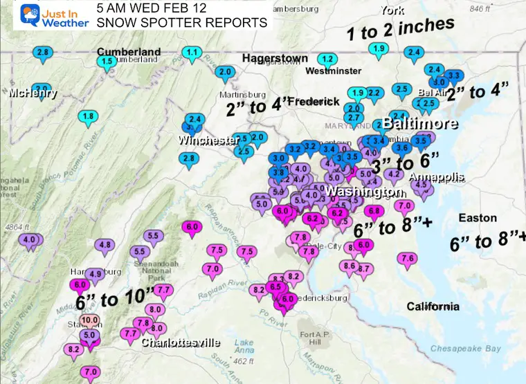
Airport Snow Reports At Midnight
- Baltimore reported 3.8”
- Washington National = 5.9”
- Washington Dulles = 4.8”
There was more that followed, so this is not the final total.
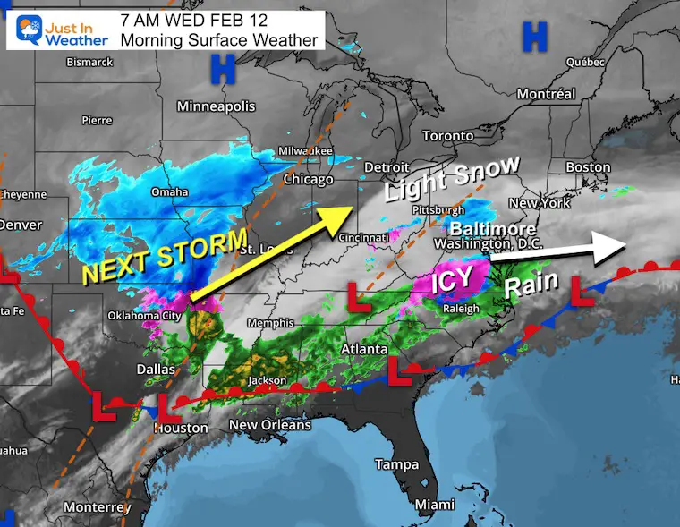
We have some light snow passing through this morning across Northern Maryland and Pennsylvania, with snow and sleet across Southern Maryland and Southeast VA…
…Current Maps And The Forecast Are Below…
Most main roads that have been treated are OK. If you are concerned, the daylight will help, and by 10 AM, we should be safe.
More mixed precipitation will develop during the afternoon and evening. Some icing farther inland, but a track north will bring more warm air and rain. Heavier rain tonight and Thursday morning, then a warm afternoon in the 50s.
Repeat This Weekend? Maybe a mix to start Saturday, then a warmer rain storm at night into Sunday.
Polar Air arrives Monday, then low confidence with another storm later in the week.
Snow Reports Early This Morning
This is NOT Final… But compared to my forecast it did work out pretty well.
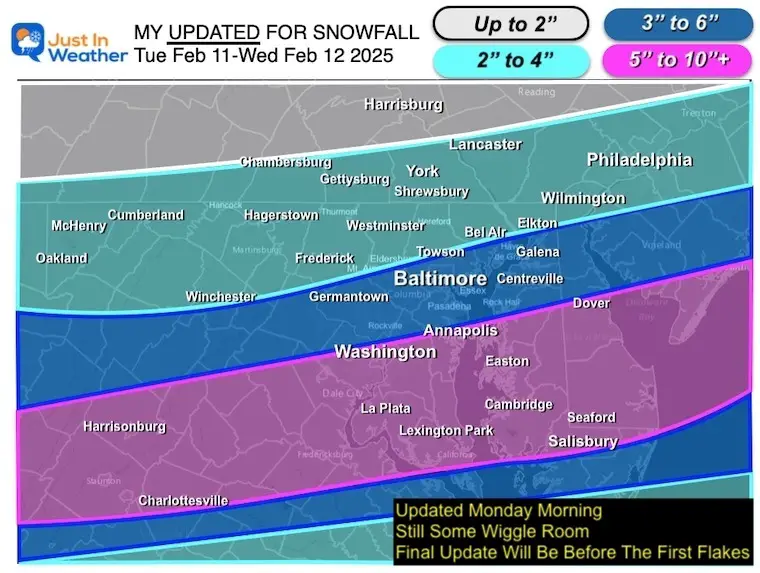
COMPARE TO MY CALL FOR SNOWFALL
CLIMATE DATA: Baltimore
TODAY February 12
Sunrise at 7:02 AM
Sunset at 5:41 PM
Normal Low in Baltimore: 26ºF
Record 5F in 1899
Normal High in Baltimore: 46ºF
Record 73ºF 1999
Baltimore Seasonal Snow
12.7”
DROUGHT UPDATE
Rainfall Deficit at BWI
Ending 2024 = -8.00″, since Jan 1 = -1.70
So we are down -9.70″, including last year!
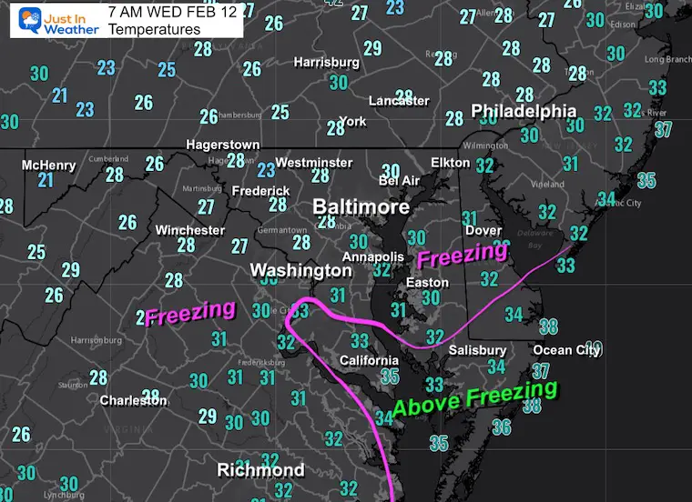
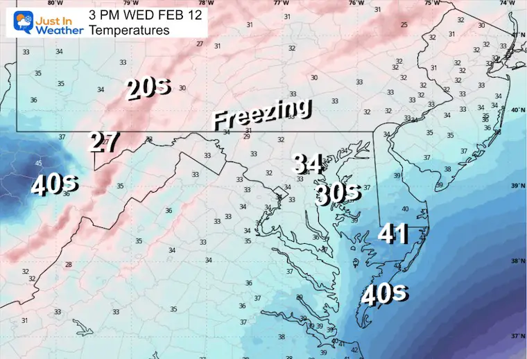
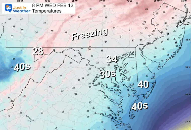
Morning Temperatures
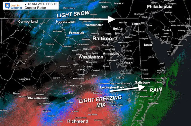
Doppler Radar Snapshot
Light snow inland may drop a coating at best.
A light icy mix is still falling across Richmond, VA, to Southern Maryland. Rain is falling across the Lower Eastern Shore from Salisbury to Ocean City.
Morning Surface Weather
We still have light snow across inland Maryland and Southern PA moving through the mountains, plus an icy mix in Southeast VA and rain moving towards the coast…
The next storm in the Central US will track farther west/north, bringing warmer air overnight and Thursday.
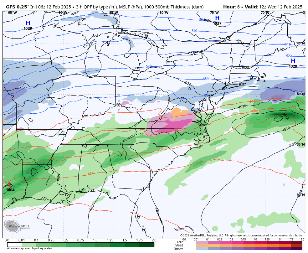
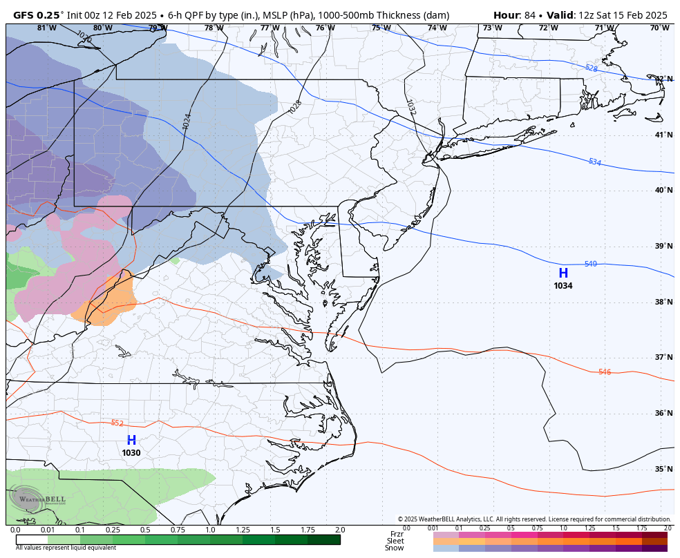
Storms Forecast: GFS Model Today Through Sunday
I am showing the colder, worst-case scenario… and will make a model comparison below.
Today: Mix to Rain lasting through tomorrow morning.
Saturday may repeat with a mix to rain that will be heavier and warmer on Sunday.
Closer Look
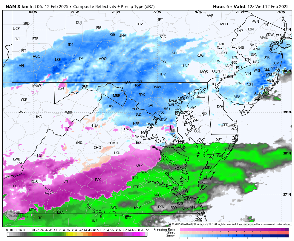
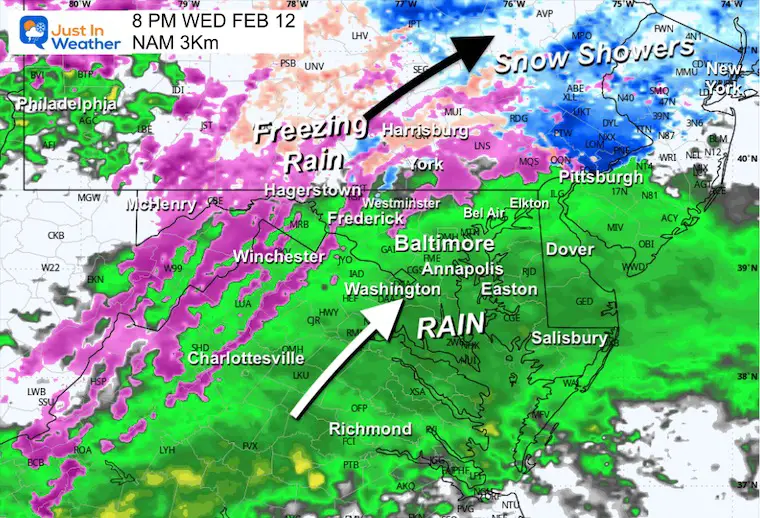
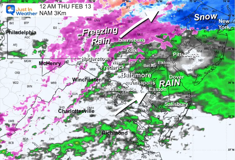
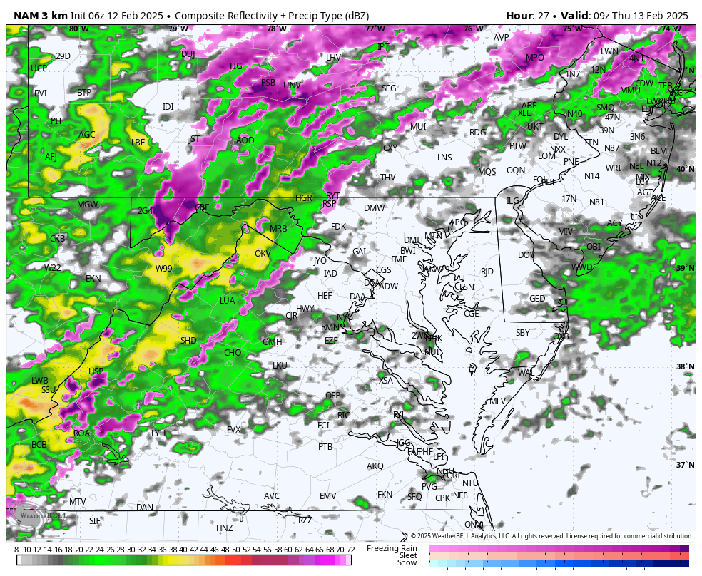
NAM 3Km Model 7 AM to Midnight
A light mix of snow and freezing rain this morning…
Developing steadier precipitation late afternoon and evening. This may be icy inland in the normally colder areas… then turn to rain.
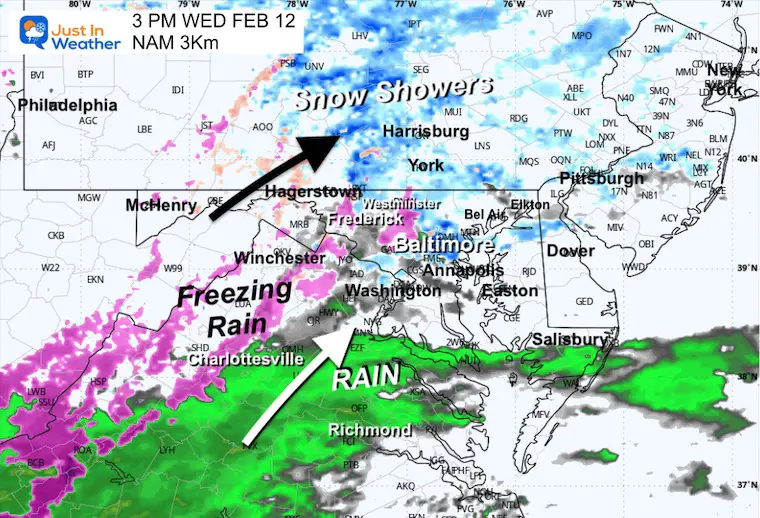
Snapshots
3 PM
8 PM
Midnight
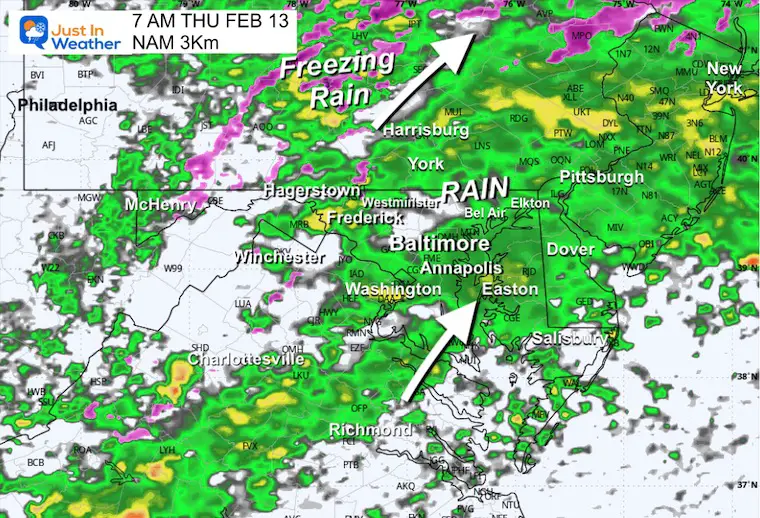
THURSDAY WEATHER
With the exception of some inland mountain valleys, most will be above freezing and get moderate to heavy rain in the morning. It will end in the afternoon and allow a warm-up.
Radar Simulation 5 AM to 7 PM
7 AM Snapshot
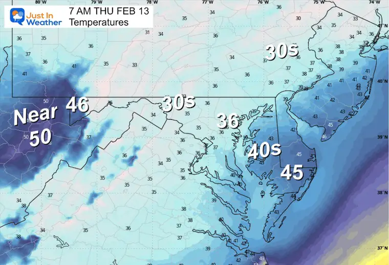
Temperatures
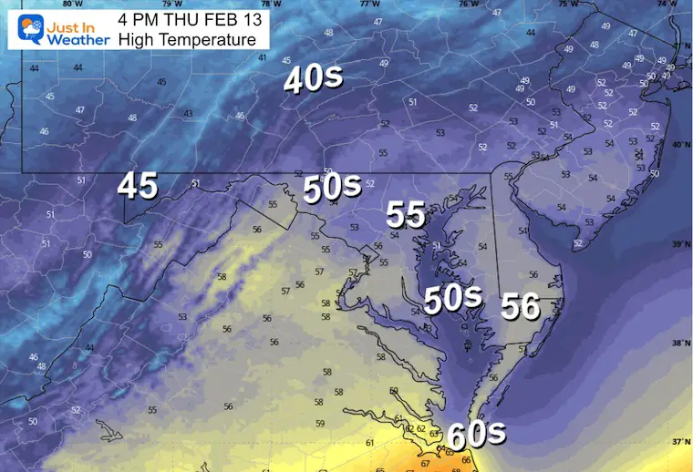
Afternoon Temperatures
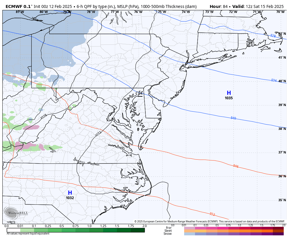
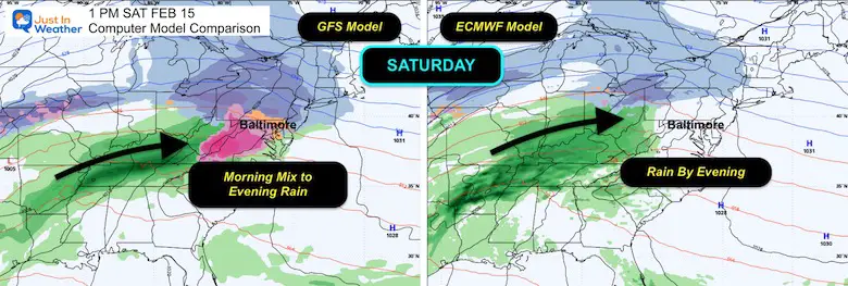
Weekend Storm: Saturday to Monday Morning
This will be a warmer track. The GFS remains the colder model trying to start with a snow and icy mix late morning, then turn to rain. The ECMWF Model is warmer with just rain later in the day.
BOTH bring warmer rain on Sunday that will be heavy at times…. then the Polar Air will arrive at the end.
GFS Model Forecast
European Model Forecast
Comparison Saturday Afternoon
Polar Air Early Next Week
The influence of the Polar Vortex will send deep arctic air into the US, Well Below Zero across the Northern Plains.
Here is a look at the morning low temperatures forecast Monday and Tuesday.
Monday Morning
Tuesday Morning
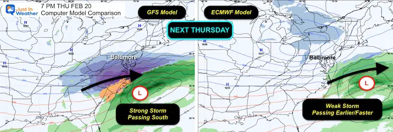
Next Week Storm?
This is still uncertain because it is more than 1 week away. As of now, the model split for Thursday:
GFS has a stronger snow event just south, while the ECMWF model has a weaker storm passing by earlier.
This will likely have adjustments as we get closer.
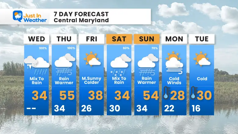
7 Day Forecast
- Wintry mix to rain today and tonight.. through tomorrow.
- Repeat Saturday and Sunday.
- Polar Air arrives on Monday
- The next storm ‘potential’ is just beyond this 7-day view.
- More will be in the pipeline as we watch the Polar Vortex’s influence in the week following this time window.
Subscribe for eMail Alerts
La Nina Advisory January 2025
Full Report

MY WINTER OUTLOOK
My Winter Outlook Report

ALSO SEE
Recent Snow Reports
SNOW REPORTS THIS SEASON
Click on the maps for that full report.
January 19 Snow Report

January 11 Snow Report

January 6 Snow Report

Previous Snow

FITF Gear on Sale

In Case You Missed This
The Faith In The Flakes Dec 5 Origin Story

Please share your thoughts and best weather pics/videos, or just keep in touch via social media.
SCHEDULE A WEATHER BASED STEM ASSEMBLY
Severe Weather: Storm Smart October and next spring Winter Weather FITF (Faith in the Flakes): November To March Click to see more and send a request for your school.

THANK YOU:
Baltimore Magazine Readers Choice Best Of Baltimore
Maryland Trek 11 Day 7 Completed Sat August 10
We raised OVER $104,000 for Just In Power Kids – AND Still Collecting More
The annual event: Hiking and biking 329 miles in 7 days between The Summit of Wisp to Ocean City.
Each day, we honor a kid and their family’s cancer journey.
Fundraising is for Just In Power Kids: Funding Free Holistic Programs. I never have and never will take a penny. It is all for our nonprofit to operate.
Click here or the image to donate:

RESTATING MY MESSAGE ABOUT DYSLEXIA
I am aware there are some spelling and grammar typos and occasional other glitches. I take responsibility for my mistakes and even the computer glitches I may miss. I have made a few public statements over the years, but if you are new here, you may have missed it: I have dyslexia and found out during my second year at Cornell University. It didn’t stop me from getting my meteorology degree and being the first to get the AMS CBM in the Baltimore/Washington region. One of my professors told me that I had made it that far without knowing and to not let it be a crutch going forward. That was Mark Wysocki, and he was absolutely correct! I do miss my mistakes in my own proofreading. The autocorrect spell check on my computer sometimes does an injustice to make it worse. I also can make mistakes in forecasting. No one is perfect at predicting the future. All of the maps and information are accurate. The ‘wordy’ stuff can get sticky. There has been no editor who can check my work while writing and to have it ready to send out in a newsworthy timeline. Barbara Werner is a member of the web team that helps me maintain this site. She has taken it upon herself to edit typos when she is available. That could be AFTER you read this. I accept this and perhaps proves what you read is really from me… It’s part of my charm. #FITF


