Tuesday Evening Update
The timeline for snow arrival worked out pretty well this afternoon. In comparison of the short range models, this part has the NAM 3 Km performing better than the HRRR. I will show both in this report for the end of this system.
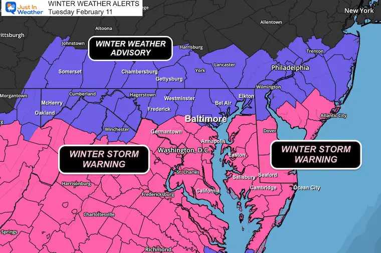
Our latest Winter Storm Warnings and Winter Weather Advisories remain in place as snow will continue through tonight. This update shows a snapshot heading into the evening and final calls for snowfall from various computer models.
UPDATE at 5 AM
I made this post on Social Media…. Most areas hit my snow forecast! There is light snow this morning.
I will have my full morning report ready around 7 AM
Overnight Preliminary Snow Spotter Reports
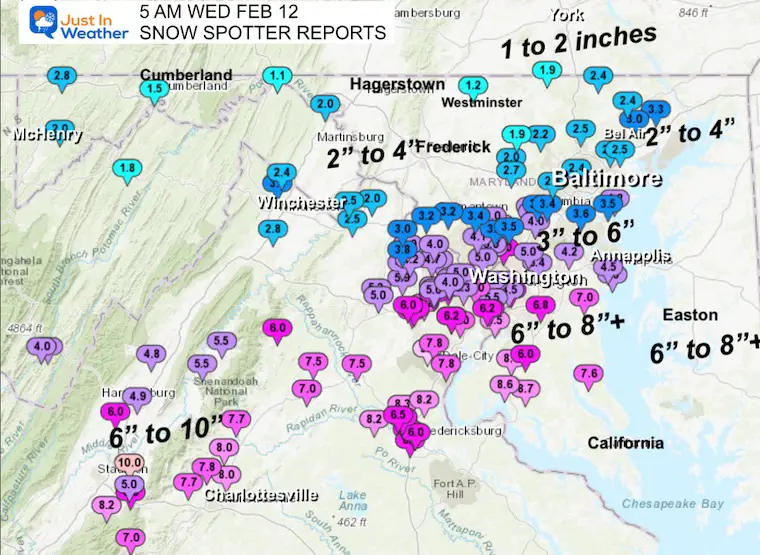
COMPARE TO: My Call For Snowfall
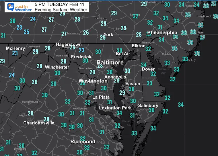
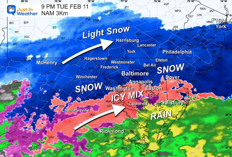
Conditions at 5 PM
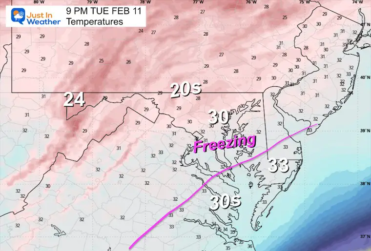
Temperatures
Most areas are below freezing. Untreated roads and where snow intensifies will begin to get very slick.
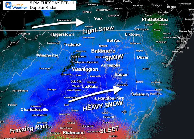
Doppler Radar Snapshot
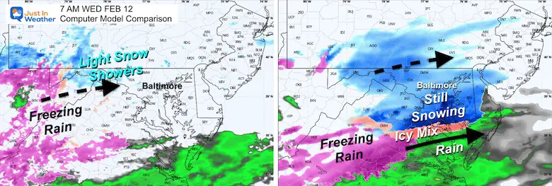
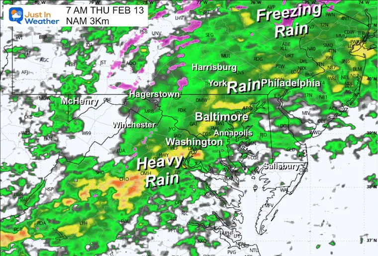
Steady snow has reached Central Maryland. Heavy snow is falling across southern Maryland, while lighter snow is falling north into southern Pennsylvania.
The intrusion of warmer air has brought sleet and freezing rain to Richmond and Southeast Virginia.
Evening Surface Weather
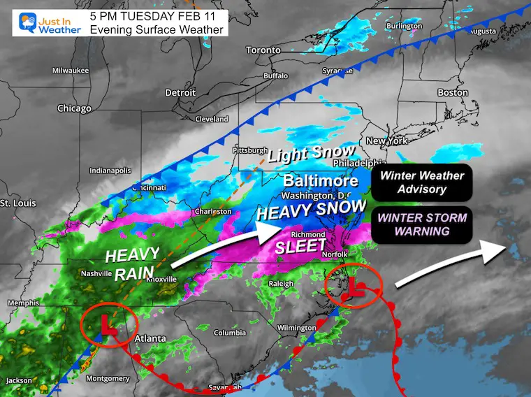
Winter Weather Alerts: From The National Weather Service
Highlights Of Challenges And More Storm Events
- As it gets dark, more roads will get slick, even if treated.
- Moderate to heavy snow will fall through midnight.
- Tonight will see the intrusion of warmer air into the heavy snow zone, which will mix in sleet into parts of Central Maryland and turn over to rain at times into Southern Maryland.
- The dry air on the north side may hold Northern Maryland and Southern Pennsylvania in the lower end of my forecast zone, but still within expectations.
- Snow will end after midnight, but additional energy may keep snow showers around Wednesday morning.
- Wednesday Evening: The next system will start with freezing rain inland, then all turn to moderate or heavy rain Thursday morning.
- This weekend: The next system may start with light snow North of Baltimore in the afternoon, and then we will all warm up with moderate to heavy rain on Sunday.
- Monday brings in Polar Air
- There may be one more storm next week, but my confidence drops. I am keeping only the ‘chance’ for something later in the week.
Full View Tuesday Evening To Thursday Afternoon
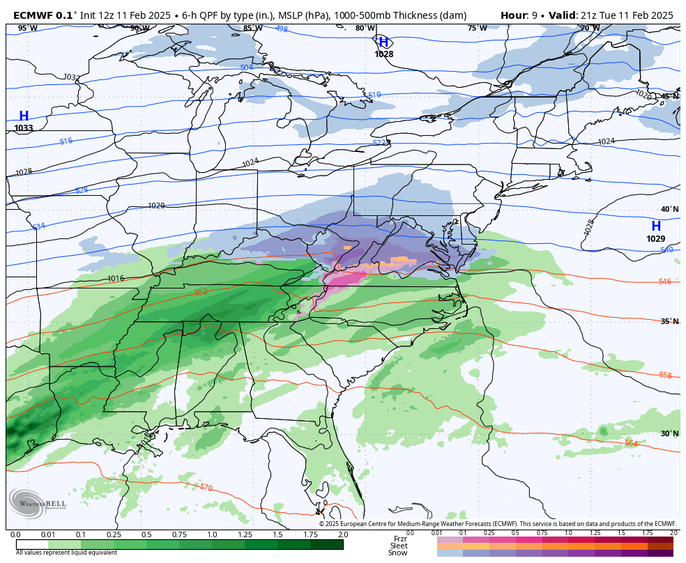
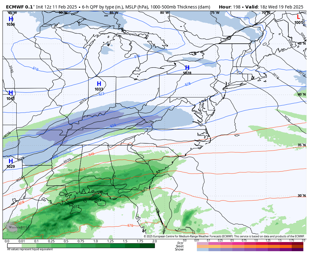
ECMWF Model
Part 1: Snow Tuesday mid-day/Afternoon ends after midnight.
Wednesday morning should be a dry break.
Part 2: Wednesday Evening Freezing rain and rain turns to all rain overnight. Ends Thursday morning with temps above freezing.
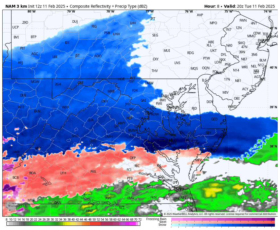
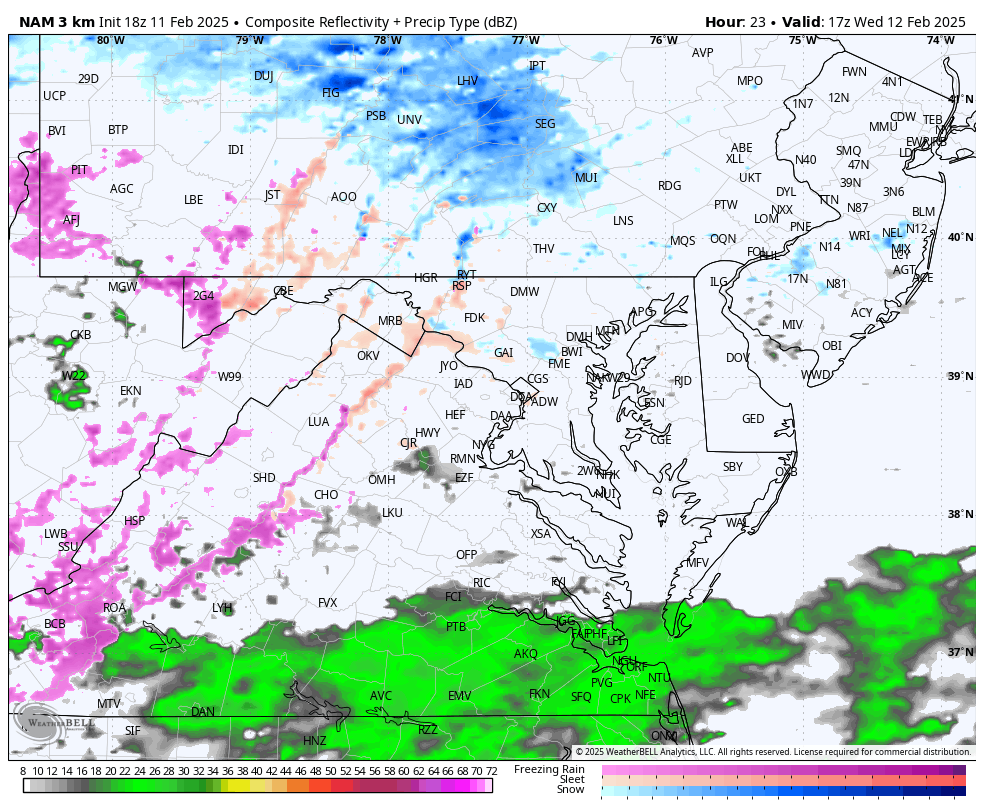
Radar Simulation NAM 3 Km 4 PM Tue to 7 AM Wed
This model has so far performed better than the HRRR Model with the arrival of the snow.
Snapshots
9 PM Tuesday
Sleet mixes into parts of Washington, D.C., and Central Maryland near Annapolis and Baltimore. Southern Maryland may turn to rain for a few hours.
Temperatures
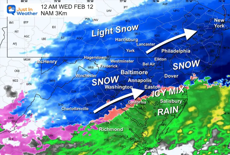
Midnight 12 AM Wednesday
Some places that do see a mix to sleet or rain in Southern Maryland will turn back to snow before this ends.
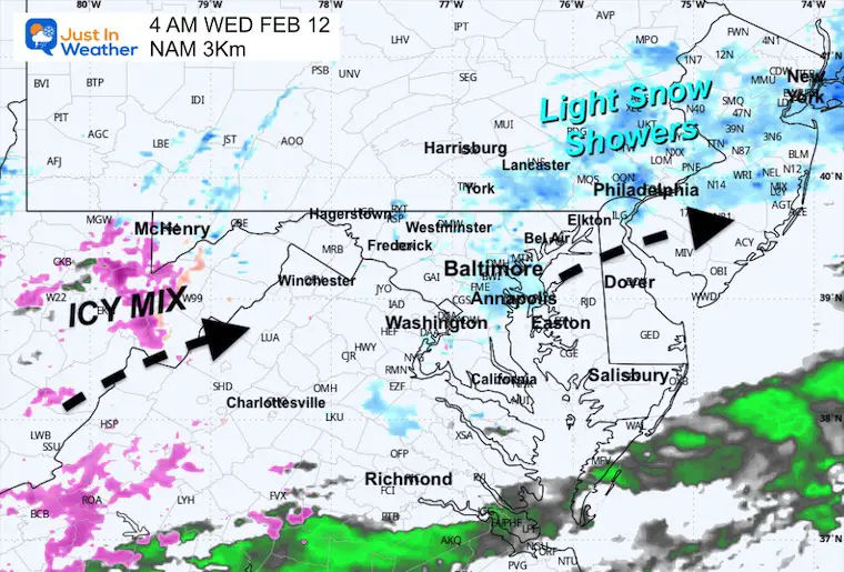
4 AM
Steady snow will end with snow showers lingering.
Model Comparison Wednesday Morning
The NAM shows this as snow to flurries, but the HRRR Model has more upper-level energy to keep a band of light snow across Central Maryland.
This is a wild card. My suggestion is that if there is falling snow, the accumulation will be minimal at this time.
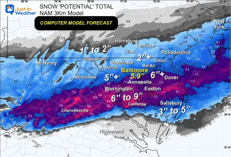
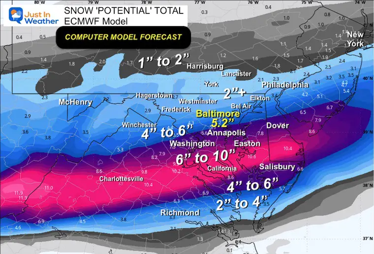
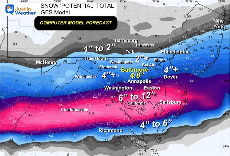
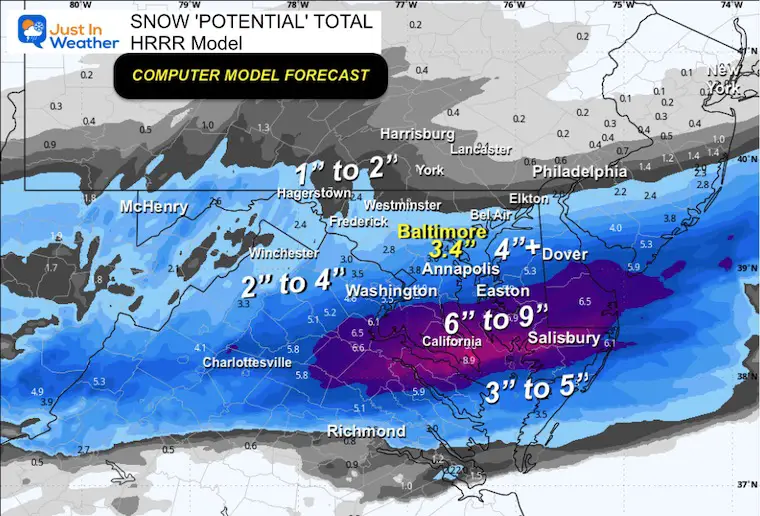
Snow POTENTIAL Forecasts
Let’s Compare Baltimore from highest to lowest and see that my Call For Snowfall still fits this range:
- NAM = 5.9”
- ECMWF = 5.2”
- GFS = 4.8”
- HRRR = 3.4”
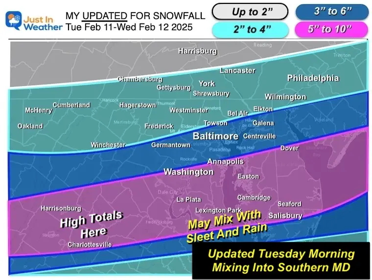
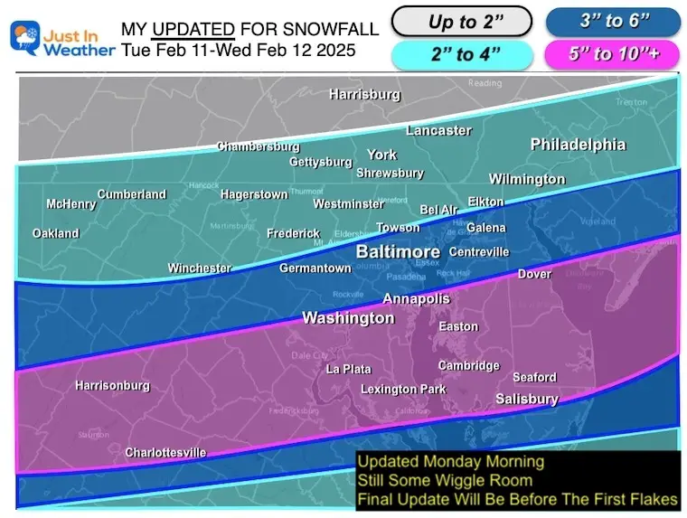
My Updated Call For Snowfall
This was my forecast Monday, and I kept this as my final call.
The point I want to make is that the snow across Northern Maryland and Southern Pennsylvania is where I have 2 to 4 inches. Some areas farther north may be closer to 2″.
Model Forecast Maps
NAM 3 Km
ECMWF
GFS Model
HRRR Model
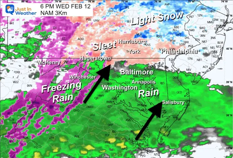
Part 2 Wednesday Afternoon and Evening
I see this developing with a mix north and rain in the southern areas that got heavier snow and sleet. The northern areas will turn to rain overnight.
NAM 3Km 12 PM Wed to 12 PM Thu
6 PM Wednesday
A brief period of freezing rain may develop across the Hereford Zone, Southern PA, and colder inland valleys. During this time, rain develops for much of the rest of the region.
7 AM Thursday Morning
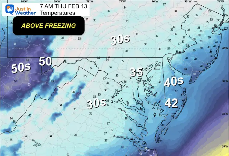
Temperatures
Most of the region will wake up to rain and temps above freezing. Roads will be wet, and snow will be melting.
Looking Ahead
A rainstorm will pull warmer air on Saturday and Sunday, and the arctic air will arrive at the end. It will turn colder and could set us up the yet another storm with snow next week.
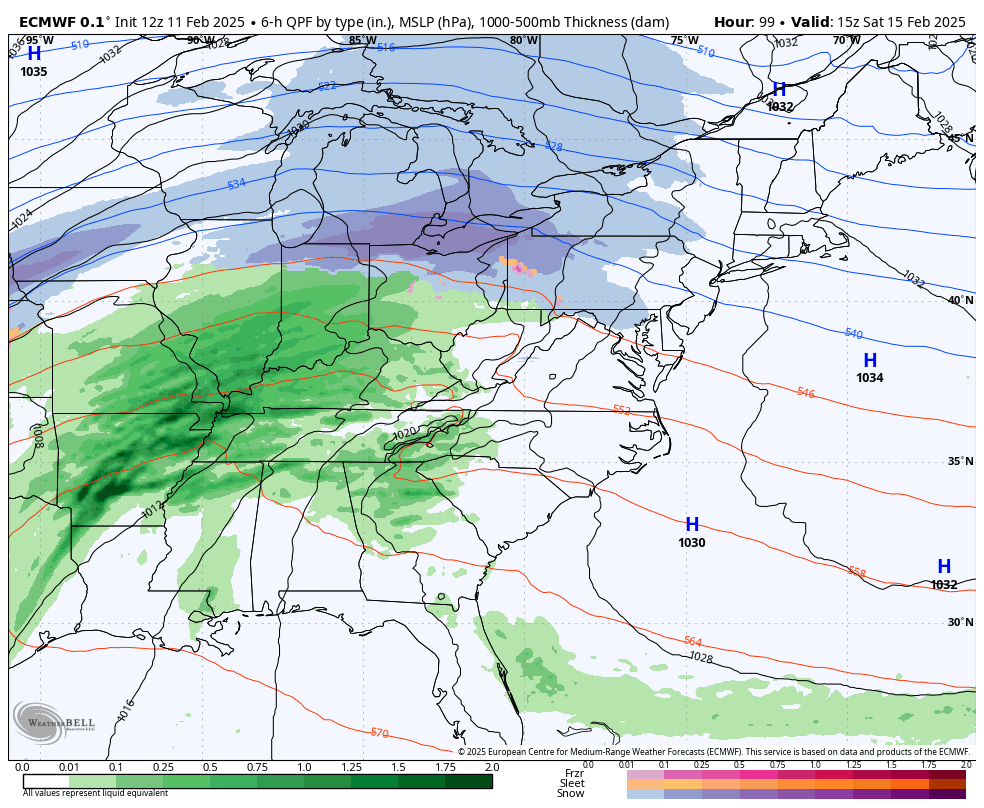
10 AM Sat to 7 AM Mon: ECMWF Model
Light snow may begin across Southern Pennsylvania, then turn to all rain with warm air filling in. Sunday looks like a warmer day with moderate to heavy rain.
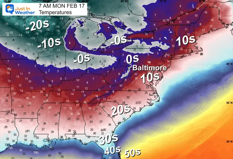
Temperatures Monday Morning
To start with temperatures on Monday morning to help show the transition back to the influence of the Polar Vortex.
Storm Forecast NEXT Wednesday Afternoon to Friday Afternoon
This violates my protocol to not show storms beyond 7 days.
This is also very different from how it looked yesterday. I DO NOT TRUST THIS FORECAST. However, the atmosphere is trying to produce something in this active environment on the edge of the Polar Front. It is worth watching, and it will change daily until we narrow the focus within five days.
Subscribe for eMail Alerts
La Nina Advisory January 2025
Full Report

MY WINTER OUTLOOK
My Winter Outlook Report

ALSO SEE
Recent Snow Reports
SNOW REPORTS THIS SEASON
Click on the maps for that full report.
January 19 Snow Report

January 11 Snow Report

January 6 Snow Report

Previous Snow

FITF Gear on Sale

In Case You Missed This
The Faith In The Flakes Dec 5 Origin Story

Please share your thoughts and best weather pics/videos, or just keep in touch via social media.
SCHEDULE A WEATHER BASED STEM ASSEMBLY
Severe Weather: Storm Smart October and next spring Winter Weather FITF (Faith in the Flakes): November To March Click to see more and send a request for your school.

THANK YOU:
Baltimore Magazine Readers Choice Best Of Baltimore
Maryland Trek 11 Day 7 Completed Sat August 10
We raised OVER $104,000 for Just In Power Kids – AND Still Collecting More
The annual event: Hiking and biking 329 miles in 7 days between The Summit of Wisp to Ocean City.
Each day, we honor a kid and their family’s cancer journey.
Fundraising is for Just In Power Kids: Funding Free Holistic Programs. I never have and never will take a penny. It is all for our nonprofit to operate.
Click here or the image to donate:

RESTATING MY MESSAGE ABOUT DYSLEXIA
I am aware there are some spelling and grammar typos and occasional other glitches. I take responsibility for my mistakes and even the computer glitches I may miss. I have made a few public statements over the years, but if you are new here, you may have missed it: I have dyslexia and found out during my second year at Cornell University. It didn’t stop me from getting my meteorology degree and being the first to get the AMS CBM in the Baltimore/Washington region. One of my professors told me that I had made it that far without knowing and to not let it be a crutch going forward. That was Mark Wysocki, and he was absolutely correct! I do miss my mistakes in my own proofreading. The autocorrect spell check on my computer sometimes does an injustice to make it worse. I also can make mistakes in forecasting. No one is perfect at predicting the future. All of the maps and information are accurate. The ‘wordy’ stuff can get sticky. There has been no editor who can check my work while writing and to have it ready to send out in a newsworthy timeline. Barbara Werner is a member of the web team that helps me maintain this site. She has taken it upon herself to edit typos when she is available. That could be AFTER you read this. I accept this and perhaps proves what you read is really from me… It’s part of my charm. #FITF


