Monday Afternoon Update
This next winter storm will actual be two storms that span between Tuesday and Thursday morning. The first one will bring moderate to heavy snow in a similar track to the storm on January 6. More will fall south of Baltimore and Washington, less north.
I realize there are many questions, and I wanted to address some highlights in these bullet points, then get to the maps and data:
Highlights:
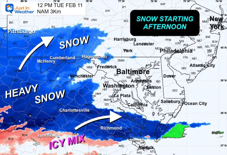
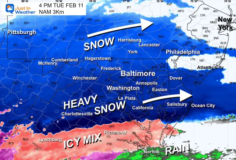
- Snow will fall and spread in cross the region. It should arrive near and South/West of Washington by noon. Then expand to reach our northern areas and into metro Philadelphia by 4 to 5 PM.
- Schools: NOT MY CALL! Stickage and road impact may be within the first 1 to 2 hours after the flakes arrive. So this may affect southern schools, while northern schools could gamble for a full day.
- TOTALS: There is a complication with the warm air advection that could THUMP heavy snow rates (across South Central VA to Southern MD) at 1 to 2 inches per hour. This may possibly include thunder, and also even mix or change to sleet at night. This will affect snow totals.
- The heavier snow zone near and south of Washington to Annapolis will get a heavy/wet snow. This will pack well, but be heavier to shovel. Add in the regions with sleet and if you have a medical condition, this is the time to find a neighborhood kid to shovel for you.
- This will all end within a few hours after midnight, so the Wednesday morning travel and schools will depend on how local road crews clear your area.
- Plane Delays? I DO NOT KNOW! I have been surprised by when flights take off in bad weather and also delayed when not o bad. Local airports, especially BWI, have great snow removal gear and plans. That is is sole purpose! They can fly and land in snow, but removal could spread out timing for take offs and landings. That in turn can spread delays. There is also a factor of the other airports, flights, and weather issues themselves….
- In the 4 inch or less areas this will be a typical snow consistency.
- The heavier snow zone near and south of Washington to Annapolis will get a heavy/wet snow. This will pack well, but be heavier to shovel. Add in the regions with sleet and if you have a medical condition, this is the time to find a neighborhood kid to shovel for you.
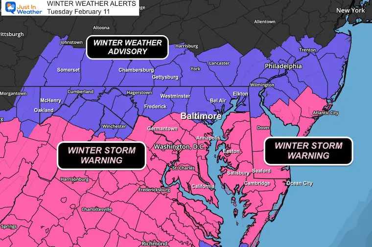
Winter Weather Alerts: From The National Weather Service
Winter Storm Warning: Washington, Howard County MD, BWI and Annapolis MD, AND Southward through Southern Maryland and Central to most of Southern Virginia South and Dover DE.
I expect this will also be included when NWS Wakefield VA posts their update:
The last regional NWS office has filled in as expected: Delmarva includes Easton, Cambridge, and Salisbury MD, Crisfield, Berlin, and Ocean City.
Winter Weather Advisory: Baltimore and north Central Maryland including I-70 Northward through Southern Pennsylvania.
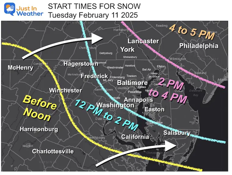
My Call For Snow Arrival Time
Note: This is a two hour window for the arrival of the first flasks. The impact of snow stickage affecting roads I anticipate will be 1 to 2 hours after it begins.
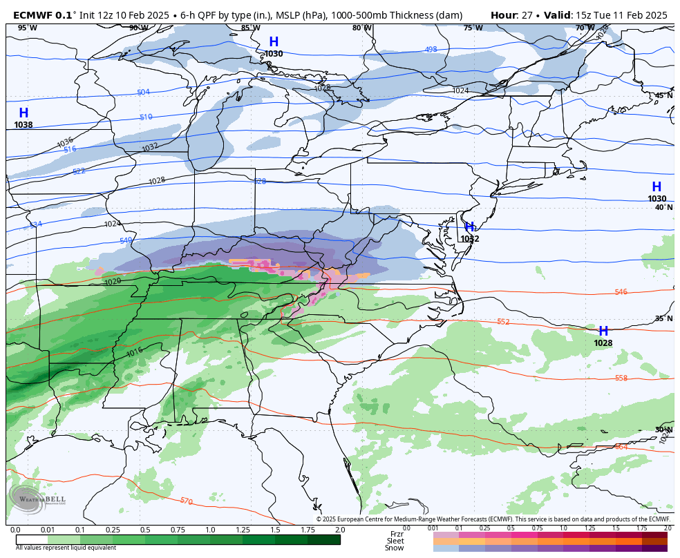
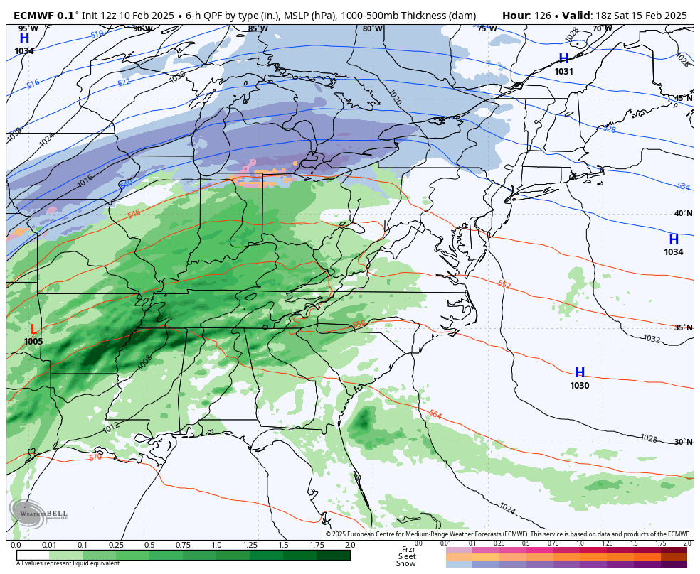
Full View Tuesday to Thursday
ECMWF Model
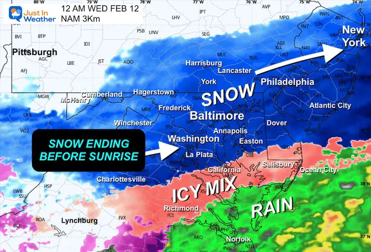
Part 1: Snow Tuesday mid day/Afternoon ends after midnight.
Wednesday Morning should be a dry break.
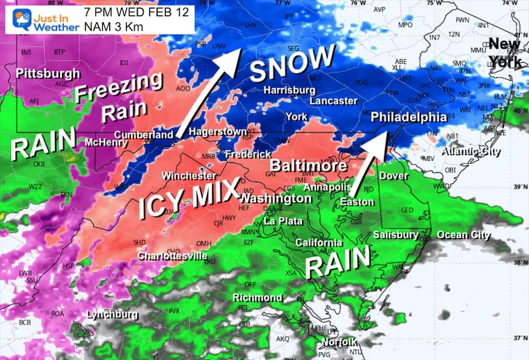
Part 2: Wednesday Evening Freezing rain and rain turns to all rain overnight. Ends Thursday morning with temps above freezing.
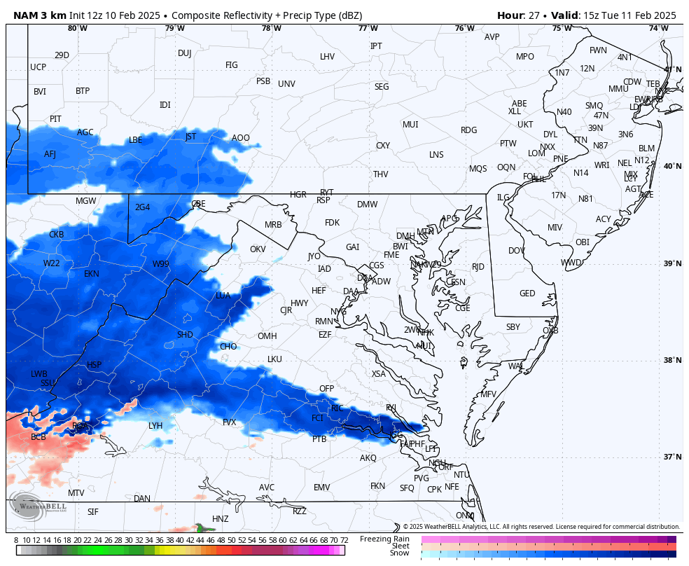
Radar Simulation NAM 3 Km
Why am I showing this when last weekend I said failed on the ice arrival time? I’m glad you asked. This is a high resolution model that can handle short range events well and it still does in my open when there is a ‘blob of snow’ to track moving in. The miss last weekend and in January was with a system forming or developing overhead. That is a weakness.
The models I am showing are NOT PERFECT but they are a guide and what I chose to be the best representation of what I expect.
Forecast (part 1) 10 AM Tue to Midnight
Snapshots
Tuesday Noon
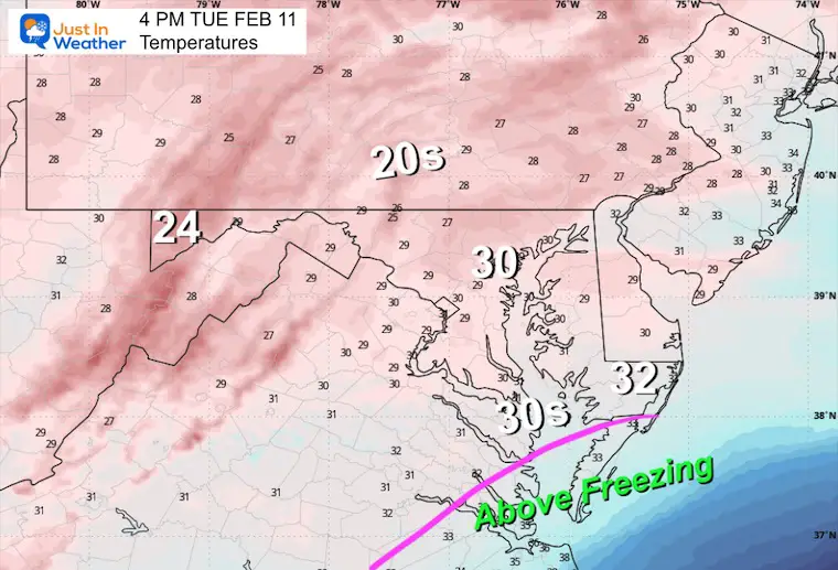
Tuesday 4 PM (Radar and Temperatures)
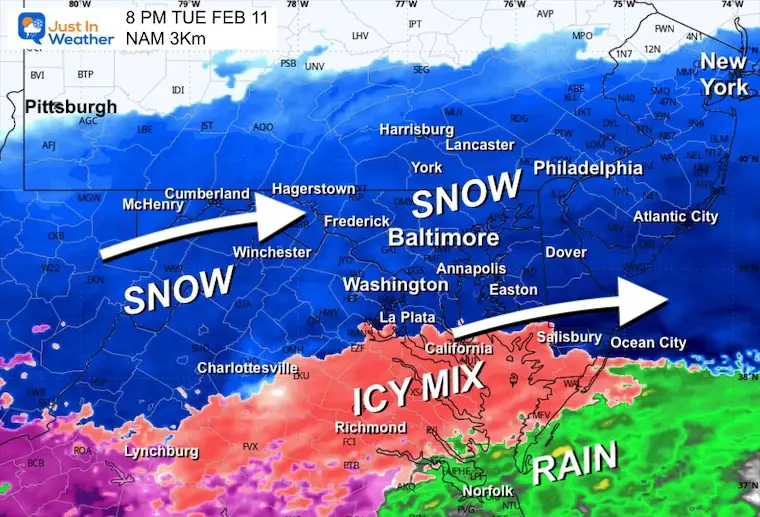
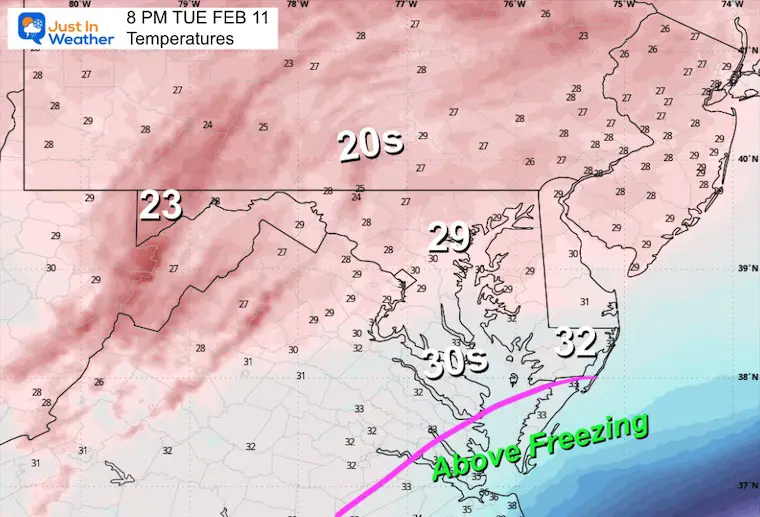
Tuesday 8 PM (Radar and Temperatures)
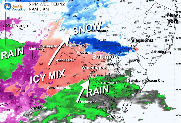
The heavy snow areas may begin to mix with sleet across Southern Maryland and Southeast VA.
Midnight
More of Southern Maryland may have sleet including The Lower Eastern Shore between Cambridge, Salisbury, Crisfield, Berlin, and Ocean City.
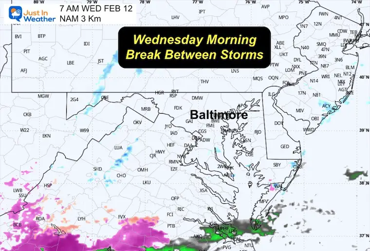
Wednesday Morning
The snow should end by 2 to 4 AM for most areas. So daybreak conditions will depend on local cleanup crews.
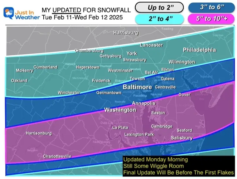
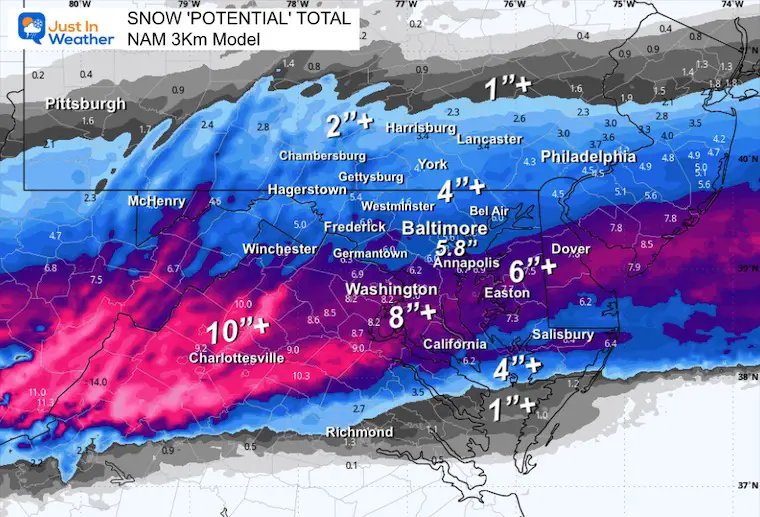
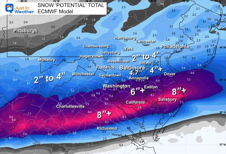
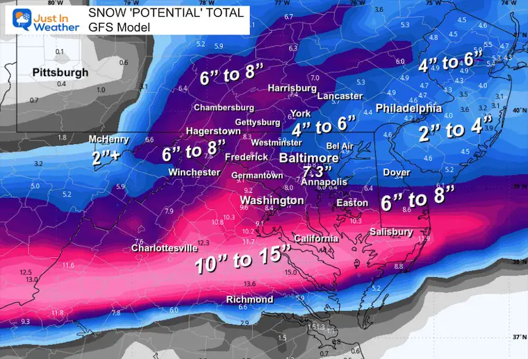
Snow POTENTIAL Forecasts
The heavier snow is set up like January 6 to fall more south of Baltimore across South Central Virginia to Southern Maryland. Some of these areas will mx with sleet. I think the NAM and ECMWF identified it better than the GFS.
There is wiggle room for slight shifts in the track… At this point the most I can foresee is 30 to 60 miles if anything.
My UPDATED Call did drop my expectations north of Baltimore…. For now.
My Updated Call For Snowfall
I made this adjustment Monday morning. There is some wiggle room, if anything could shift or expand snow zones 30 to 60 miles based on final track.
In the 4 inch or less areas this will be a typical snow consistency.
The heavier snow zone near and south of Washington to Annapolis will get a heavy/wet snow. This will pack well, but be heavier to shovel. Add in the regions with sleet and if you have a medical condition, this is the time to find a neighborhood kid to shovel for you.
Southern Maryland: South of Salisbury I may need to adjust. I am trying to worth through the potential sleet mixing in and affecting totals.
NAM 3 Km Model Snow
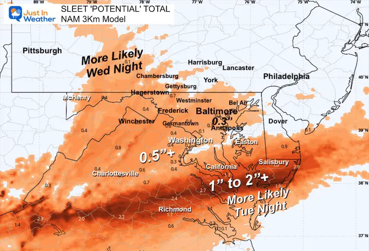
NAM 3 Km Model Sleet
This is where I see the model doing better AND the conditions in that zone being worse.
ECWMF Model
GFS Model
I do not trust these results. I think they are too high. But I am showing them in case we do overachieve (in my opinion), then this model deserves the credit.
Part 2 Wednesday Afternoon and Evening
I see this developing with a mix north and rain in the southern areas that got heavier snow and sleet. The northern areas will turn to rain overnight.
5 PM Wednesday
7 PM Wednesday
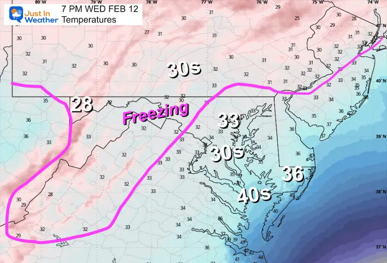
Temperatures
The warming trend will expand north.
Looking Ahead
A rain storm will pull warmer air in Saturday and Sunday, the arctic air arrives at the end. It will turn colder and could set us up the yet another storm with snow next week.
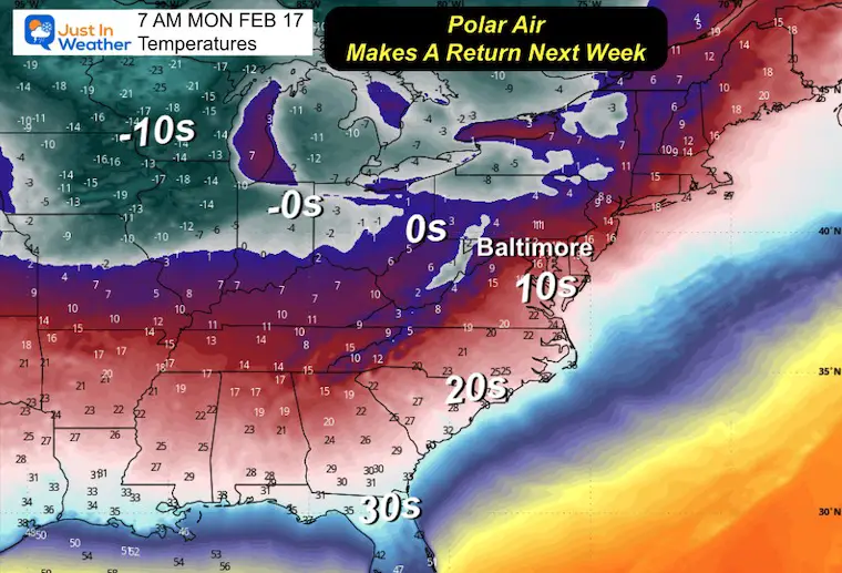
Temperatures Monday Morning
to start with temperatures on Monday morning to help show the transition back to the influence of the Polar Vortex.
Storm Forecast Saturday Afternoon to Thursday Morning
This violates my protocol to not show storms beyond 7 days. However, in this active pattern we will continue to have more impulses. This is NOT perfect and I expect time and track adjustments next week. I am showing this simply as a demonstration of the potential for this weather pattern to continue another week.
Subscribe for eMail Alerts
La Nina Advisory January 2025
Full Report

MY WINTER OUTLOOK
My Winter Outlook Report

ALSO SEE
Recent Snow Reports
SNOW REPORTS THIS SEASON
Click on the maps for that full report.
January 19 Snow Report

January 11 Snow Report

January 6 Snow Report

Previous Snow

FITF Gear on Sale

In Case You Missed This
The Faith In The Flakes Dec 5 Origin Story

Please share your thoughts and best weather pics/videos, or just keep in touch via social media.
SCHEDULE A WEATHER BASED STEM ASSEMBLY
Severe Weather: Storm Smart October and next spring Winter Weather FITF (Faith in the Flakes): November To March Click to see more and send a request for your school.

THANK YOU:
Baltimore Magazine Readers Choice Best Of Baltimore
Maryland Trek 11 Day 7 Completed Sat August 10
We raised OVER $104,000 for Just In Power Kids – AND Still Collecting More
The annual event: Hiking and biking 329 miles in 7 days between The Summit of Wisp to Ocean City.
Each day, we honor a kid and their family’s cancer journey.
Fundraising is for Just In Power Kids: Funding Free Holistic Programs. I never have and never will take a penny. It is all for our nonprofit to operate.
Click here or the image to donate:

RESTATING MY MESSAGE ABOUT DYSLEXIA
I am aware there are some spelling and grammar typos and occasional other glitches. I take responsibility for my mistakes and even the computer glitches I may miss. I have made a few public statements over the years, but if you are new here, you may have missed it: I have dyslexia and found out during my second year at Cornell University. It didn’t stop me from getting my meteorology degree and being the first to get the AMS CBM in the Baltimore/Washington region. One of my professors told me that I had made it that far without knowing and to not let it be a crutch going forward. That was Mark Wysocki, and he was absolutely correct! I do miss my mistakes in my own proofreading. The autocorrect spell check on my computer sometimes does an injustice to make it worse. I also can make mistakes in forecasting. No one is perfect at predicting the future. All of the maps and information are accurate. The ‘wordy’ stuff can get sticky. There has been no editor who can check my work while writing and to have it ready to send out in a newsworthy timeline. Barbara Werner is a member of the web team that helps me maintain this site. She has taken it upon herself to edit typos when she is available. That could be AFTER you read this. I accept this and perhaps proves what you read is really from me… It’s part of my charm. #FITF


