January 19 Snow Report And Grade My Forecast
Monday January 20 2025
The winter weather event that crossed the Mid-Atlantic states on Sunday was the precursor of a Polar Air Mass invading much of the nation. While it was cold before it arrived and bitterly cold to follow, there was a brief warm-up in between, and that seemed to make the difference.
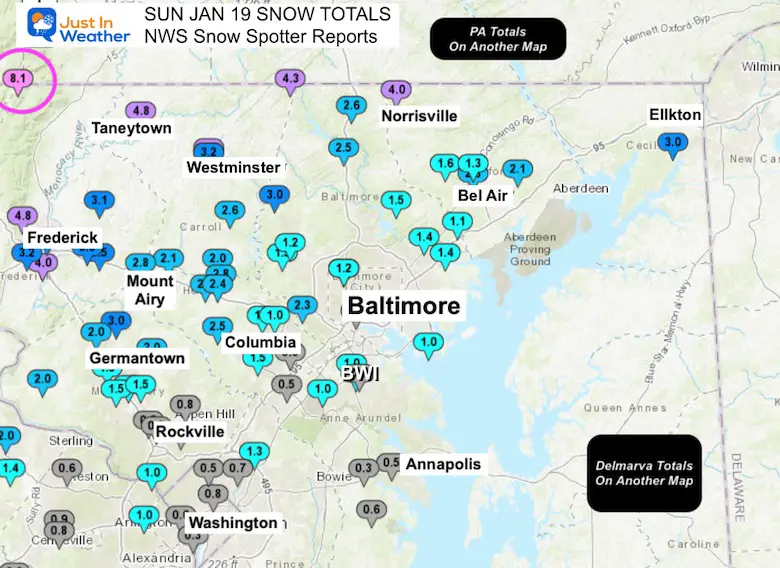
Baltimore’s BWI reported 1.0 inch of snow. My forecast there was 2 to 4 inches. That can be seen as a bit off by just one inch from the zone or one-half of the call, which makes it seem worse.
The seasonal total is now 8.9 inches of snow, which is above average pace.
Washington DC Area
- Reagan National = 0.3”
- Dulles Airport = 1.4”
See more snow reports below.
Reading through comments on social media, there were a lot of people who said I got the forecast right and there were also a lot who said this was a disappointment or just a Bust! Some even just flat-out told me I suck! Really, I was right AND wrong, but that does not matter if you are in an area that got less snow. You probably do not care what I measured or anyone else because that does not apply to you.
I had been following this system for just over a week and there was anticipation for a big impact. In all of my analysis, explanations, models, and even contrasting with The National Weather Service. I have taken account of what I got right AND what I got wrong. I will address those here as they may explain a little more than just the maps.
In this report, I have quite a few maps, a list of storm spotter reports below, and, most importantly, my assessment of what went right and wrong in my analysis, which I shared with you over the last week.
As always, I would like for you to go back to my social media and let me know what you think of my forecast:
Pass
- The overall timing was good. However, I initially said sunrise to start, but changed it the day before to a 9 AM to Noon start.
- The window for heavy snow I called correctly between 2 PM and 6 PM.
- The Winter Storm Warning areas were in a 4—to 6-inch snow band, and I included bursts up to 7 inches. Some went higher.
- I got the call correct in the high mountains.
- Moderate to heavy snow fell in Philadelphia during the Eagles home playoff game.
Fail
- I did miss the delay of the freezing temps. This was later.. So the longer time of wet roads really hurt people who canceled morning or midday plans.
- The net result of snow totals in metro areas was lower:
- Many in my 2 to 4-inch range ended up with 1 to 3 inches.
- Annapolis and along the Rt 50 corridor were just too warm. I was wrong because the rain didn’t change to snow until later, and they were under the low end of my zone, under 1 inch.
- I shared a discussion about using the Kuchera Method to account for the cold and Fluff Factor with snow ratios. That did NOT apply with the milder temps… except for the farther inland areas that did drop into the lower 20s.
My biggest mistake:
I was openly favoring the Canadian Model for days. In 2014, it showed me that it did the best job with storms in a polar air pattern. It was best with the delay of the freezing and keeping the rain line through Baltimore later. But I caved to the GFS and European Models dragging the cold air through sooner. I came up with a blend of all and added the southern bias, considering the snow from the prior two events favored southern areas.
My Grade For Myself
The overall region (not just your house):
C+
Digging Deeper
Three Hours And 30 Miles Made The Difference
- We had three hours of snow and sleet that did not stick. This was due to a delay in the colder air. The net result was snow totals roughly 30 miles north compared to my snow forecast bands.
- The thing that really sticks out with this storm is that it was developing right on top of us.
- Time and location were critical.
- The Canadian Model did the best job for the three days leading up to the storm with the location of the warmer air and rain line. This was not perfect because in the cold zone it predicted nearly double the snow that actually fell.
- This model was matched by the HRRR model in the short range (within one day). I showed both in my various reports.
- The highly reliable European ECWMF Model did the poorest job with the polar air. It brought that too far south and had nearly all of Maryland in snow.
- The GFS Model was in the middle and did a decent job, but it was also too far south with the Polar Air.
- Most of the time when polar air is on the move, it will arrive later than forecast. Even out a few hours, which is why many storms can bust right along the I-95 corridor.
Snow Spotter Reports
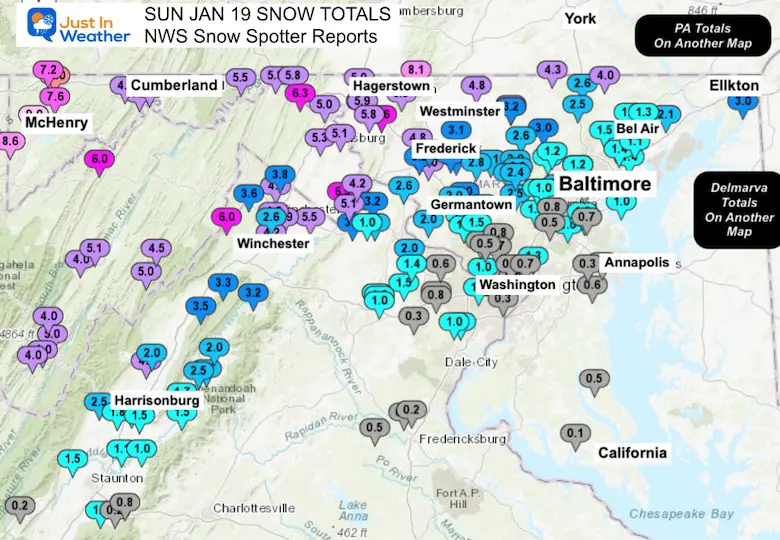
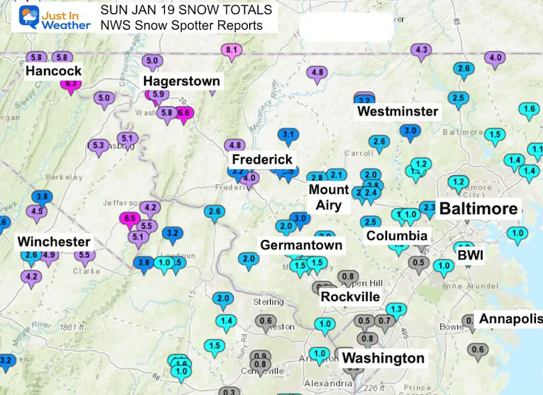
This is the map only from the NWS Sterling VA Office. The PA and Delmarva numbers are on additional maps below.
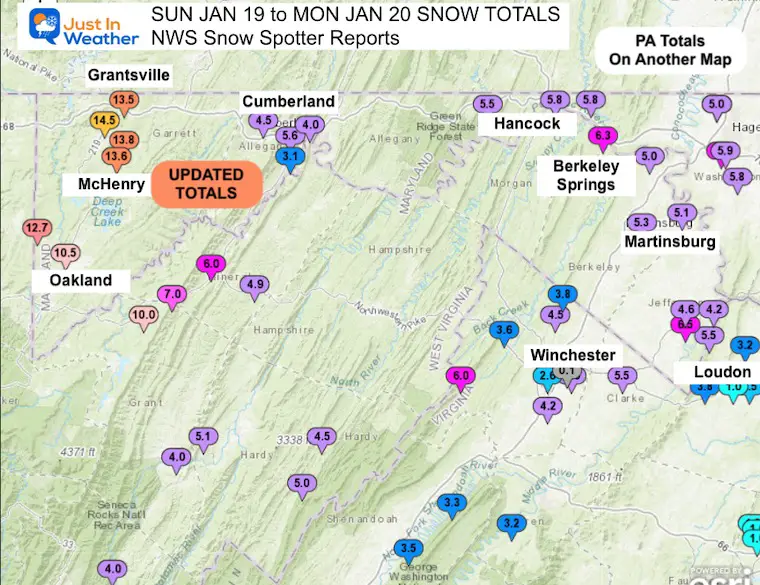
UPDATED: Western Maryland received additional snow on January 20. Their local snow map below and the spotter list have been updated to show higher totals above 12 inches.
My Final Call For Snowfall
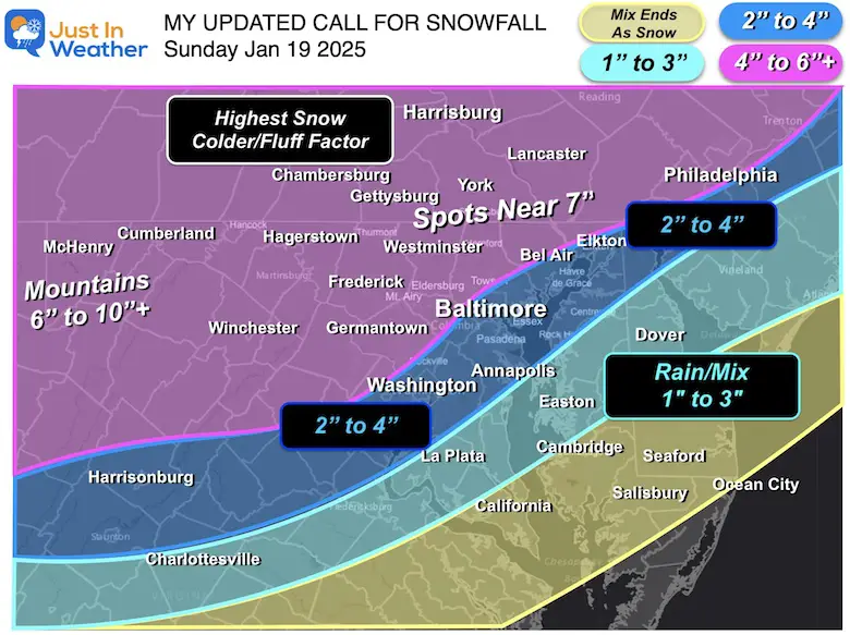
I made this map on Saturday Morning, the day before the storm…
Again, if my 1 to 3-inch range was 30 miles north, and the other zones pushed north, that would have worked out better. But the mountains and high spots in the warning zone worked.
Closer Maps Locations
Central Maryland
Capital District To Front Ridge
Western Maryland Mountains
UPDATED: Top spot in the state: Grantsville = 14.5″
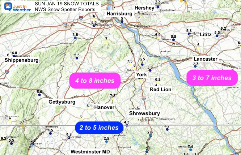
Southern Pennsylvania
Delmarva and Metro Philadelphia
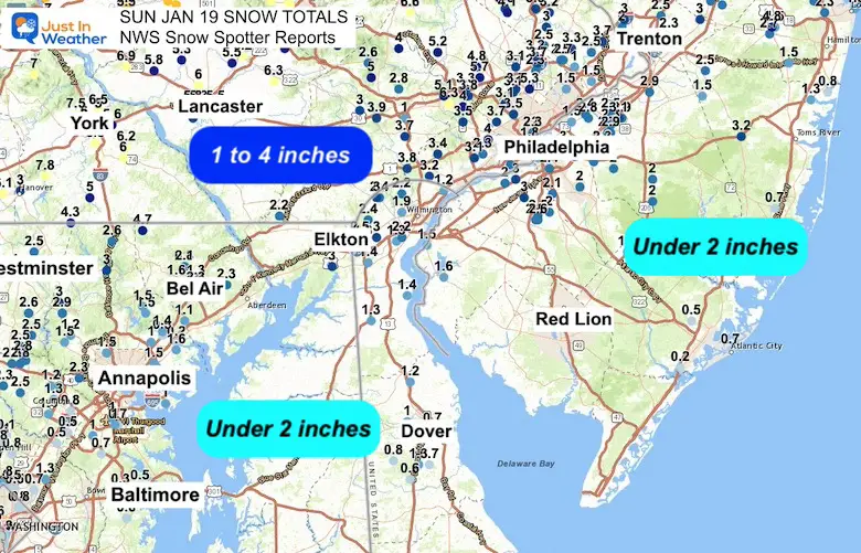
See the list from spotters below
Snow Spotter Reports
**********STORM TOTAL SNOWFALL (AT LEAST 0.1 INCH)**********
LOCATION TOTAL TIME/DATE COMMENTS
SNOWFALL MEASURED
(inches)
DISTRICT OF COLUMBIA
Catholic University 0.8 736 PM 1/19 NWS Employee
Reagan National Apt 0.3 700 PM 1/19 Official NWS Obs
Dulles International 1.4 700 PM 1/19 Official NWS Obs
MARYLAND
…Allegany County…
Potomac Park 2 NW 5.6 1213 AM 1/20 Dept of Highways
Bellegrove 1 SSE 5.5 700 PM 1/19 Trained Spotter
Frostburg 2 ENE 4.5 544 PM 1/19 Trained Spotter
Ridgeley 1 NW 4.0 541 PM 1/19 Trained Spotter
Brady 1 W 3.1 700 PM 1/19 Trained Spotter
…Anne Arundel County…
Severn 1 W 1.0 635 PM 1/19 Public
Baltmore-Washington 1.0 900 PM 1/19 Dept of Highways
Bwi Airport 1.0 700 PM 1/19 Official NWS Obs
Glen Burnie 1 WSW 0.7 554 PM 1/19 Trained Spotter
Birdsville 0.6 900 PM 1/19 NWS Employee
Parole 0.5 900 PM 1/19 Dept of Highways
Crownsville 3 SSW 0.3 800 PM 1/19 Trained Spotter
…Baltimore County…
Reisterstown 2 NW 3.0 930 PM 1/19 Co-Op Observer
Bentley Springs 6 S 3.0 900 PM 1/19 Dept of Highways
Bentley Springs 1 E 2.6 700 PM 1/19 Trained Spotter
Oella 2 NNE 2.3 435 PM 1/19 Trained Spotter
Reisterstown 1 NW 2.2 500 PM 1/19 CoCoRaHS
Rosedale 1 E 1.5 900 PM 1/19 Dept of Highways
Randallstown 2 NW 1.5 632 PM 1/19 Trained Spotter
Long Green 2 NW 1.5 800 PM 1/19 Trained Spotter
White Marsh 2 E 1.4 830 PM 1/19 Updated total
Perry Hall 1 NNE 1.4 705 PM 1/19 Trained Spotter
Owings Mills 1.2 700 PM 1/19 Dept of Highways
Kingsville 1 E 1.1 830 PM 1/19 Trained Spotter
Edgemere 1.0 545 PM 1/19 Trained Spotter
Fullerton 1 N 1.0 1000 PM 1/19 Trained Spotter
…Baltimore City…
Pikesville 3 SE 1.5 800 PM 1/19 Trained Spotter
Pimlico SE 1.2 505 PM 1/19 Trained Spotter
Baltimore 2 SW 0.6 515 PM 1/19 NWS Employee
…Calvert County…
Prince Frederick 1 S 0.5 900 PM 1/19 Dept of Highways
…Carroll County…
Taneytown 4.8 802 PM 1/19 Public
Millers 4 NE 4.3 908 PM 1/19 Co-Op Observer
Westminster 1 NNE 4.0 900 PM 1/19 Dept of Highways
Westminster 3.6 830 PM 1/19 Trained Spotter
Westminster SE 3.2 530 PM 1/19 Trained Spotter
Gamber 1 WNW 2.6 912 PM 1/19 CoCoRaHS
Watersville 1 N 2.1 620 PM 1/19 Trained Spotter
Sykesville 1 NNW 2.0 430 PM 1/19 NWS Employee
…Cecil County…
Elkton 2 W 3.0 900 PM 1/19 Dept of Highways
…Frederick County…
Middletown 7.0 700 PM 1/19 Broadcast Media
Myersville 5.5 700 PM 1/19 Broadcast Media
Smithsburg 3 SE 5.5 650 PM 1/19 Trained Spotter
Bloomfield 2 WSW 4.8 745 PM 1/19 Trained Spotter
Ballenger Creek 1 E 4.0 900 PM 1/19 Dept of Highways
Thurmont 1 NE 3.8 940 PM 1/19 Trained Spotter
New Market 3.5 635 PM 1/19 Trained Spotter
New Market 2 NW 3.3 700 PM 1/19 CoCoRaHS
Ballenger Creek 1 NN 3.2 615 PM 1/19 Trained Spotter
Libertytown 2 W 3.1 427 PM 1/19 Trained Spotter
Frederick 1 SE 3.0 440 PM 1/19 Trained Spotter
Mount Airy 1 WSW 2.8 935 PM 1/19 Trained Spotter
Buckeystown 3 SW 2.7 1000 PM 1/19 Trained Spotter
Point Of Rocks 1 NE 2.6 850 PM 1/19 Trained Spotter
…Garrett County…
Grantsville 5 W 13.5 400 AM 1/20 Dept of Highways
Mc Henry 9.0 950 PM 1/19 Dept of Highways
Oakland 10.5 355 AM 1/20 County Official
Accident 3 NNE 13.0 230 AM 1/20 Dept of Highways
Mountain Lake Park 1 6.0 400 AM 1/20 Dept of Highways
…Harford County…
Norrisville 1 WSW 4.0 630 PM 1/19 CoCoRaHS
Churchville 1 SE 2.3 900 PM 1/19 Dept of Highways
Bel Air 2.3 900 PM 1/19 Other Federal
Chrome Hill 2 SE 2.1 1040 PM 1/19 Trained Spotter
Fallston 3 N 1.6 800 PM 1/19 Trained Spotter
Bynum 1 E 1.3 811 PM 1/19 Trained Spotter
…Howard County…
Gaither 2 SSE 2.8 1100 PM 1/19 Trained Spotter
Sykesville 2 SSE 2.8 800 PM 1/19 Trained Spotter
Gaither 2 SSW 2.5 904 PM 1/19 Trained Spotter
Dayton 1 NE 2.5 900 PM 1/19 Dept of Highways
Simpsonville 1.5 943 PM 1/19 Trained Spotter
Historic Ellicott Ci 1.2 624 PM 1/19 NWS Employee
Ellicott City 1.0 808 PM 1/19 Broadcast Media
Elkridge 2 W 0.8 800 PM 1/19 Trained Spotter
Jessup 2 WSW 0.5 700 PM 1/19 Trained Spotter
…Montgomery County…
Damascus 3 SSW 3.0 750 PM 1/19 Co-Op Observer
Poolesville 2.0 620 PM 1/19 Trained Spotter
Clarksburg 2.0 441 PM 1/19 Emergency Mngr
Laytonsville 2.0 523 PM 1/19 Other Federal
Silver Spring 1.8 900 PM 1/19 Trained Spotter
Gaithersburg 1 E 1.6 432 PM 1/19 Trained Spotter
Germantown 1 SE 1.5 803 PM 1/19 Trained Spotter
Gaithersburg 1 SW 1.5 500 PM 1/19 Trained Spotter
Gaithersburg 2 E 1.5 525 PM 1/19 NWS Employee
Glen Echo 1.0 441 PM 1/19 Emergency Mngr
Rockville 1 SSE 0.8 800 PM 1/19 Trained Spotter
Norbeck 1 ESE 0.8 1000 PM 1/19 Trained Spotter
Glenmont 1 SW 0.7 630 PM 1/19 Trained Spotter
Rockville 2 SE 0.5 707 PM 1/19 Trained Spotter
Takoma Park 0.5 441 PM 1/19 Trained Spotter
…Prince George County…
Greenbelt 1 N 1.3 510 PM 1/19 CoCoRaHS
College Park 1 S 0.7 700 PM 1/19 Trained Spotter
…St. Mary’s County…
Clements 3 E 0.1 900 PM 1/19 Dept of Highways
…Washington County…
Sabillasville 2 NNW 8.1 730 PM 1/19 CoCoRaHS
Boonsboro 3 NNE 6.6 730 PM 1/19 Trained Spotter
Hagerstown 7 E 6.2 1030 PM 1/19 Public
Funkstown 2 WSW 6.0 900 PM 1/19 Dept of Highways
Funkstown 1 WSW 5.9 633 PM 1/19 Public
Hancock 1 ESE 5.8 700 PM 1/19 Trained Spotter
Fairplay 3 ENE 5.8 700 PM 1/19 Trained Spotter
Pecktonville 3 NNW 5.8 714 PM 1/19 NWS Employee
Long Meadow 2 W 5.3 930 PM 1/19 Trained Spotter
Maugansville WSW 5.0 500 PM 1/19 Trained Spotter
…Pennsylvania…
…Adams County…
Carroll Valley 7.0 in 0800 AM 01/20 Trained Spotter
1 SW Mcsherrystown 6.1 in 0710 PM 01/19 Trained Spotter
Littlestown 6.0 in 0833 PM 01/19
1 WSW Cashtown 5.6 in 0540 PM 01/19 CO-OP Observer
3 N York Springs 5.5 in 0530 PM 01/19 Public
Elizabethtown 6.9 in 0800 PM 01/19 Trained Spotter
1 ENE New Holland 6.3 in 0830 PM 01/19
Ephrata 6.2 in 0930 PM 01/19 Public
1 E East Petersburg 6.0 in 0745 PM 01/19
2 NNE Mount Joy 5.8 in 0500 PM 01/19 Trained Spotter
3 N Millersville 5.8 in 0827 PM 01/19 Public
3 NNE Terre Hill 5.6 in 0850 PM 01/19 Public
1 WSW Akron 5.5 in 0628 PM 01/19
1 E Lancaster 5.5 in 0837 PM 01/19
2 W Lancaster 5.3 in 0700 PM 01/19
1 NNW Manheim 5.3 in 0956 PM 01/19
Millersville 5.3 in 0730 AM 01/20 Trained Spotter
2 W Lancaster 3.5 in 0500 PM 01/19
Millersville 3.3 in 0500 PM 01/19 Public
..York County…
2 SW Spring Grove 7.8 in 0730 PM 01/19 Trained Spotter
3 WNW Emigsville 7.5 in 1000 PM 01/19 Public
3 WNW Emigsville 7.5 in 0958 AM 01/20 Trained Spotter
2 SE Siddonsburg 7.0 in 1000 PM 01/19 Trained Spotter
2 NE Emigsville 6.5 in 1010 PM 01/19
2 SE York 6.3 in 0823 PM 01/19 Public
1 NW Windsor 6.2 in 1100 PM 01/19 Trained Spotter
1 WSW Emigsville 6.0 in 0700 PM 01/19 Trained Spotter
Red Lion 6.0 in 0721 PM 01/19
1 NNW Stonybrook 5.6 in 0900 PM 01/19 Emergency Mngr
Glen Rock 5.0 in 0530 PM 01/19 Public
New Salem 5.0 in 0830 AM 01/20 Trained Spotter
Hanover 3.0 in 0300 PM 01/19 Public
Recent Snow Reports
SNOW REPORTS THIS SEASON
Click on the maps for that full report.
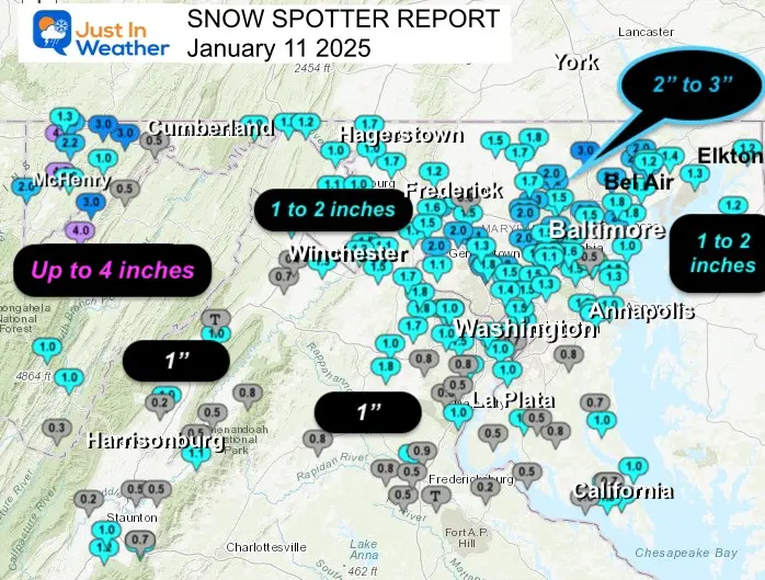
January 11 Snow Report
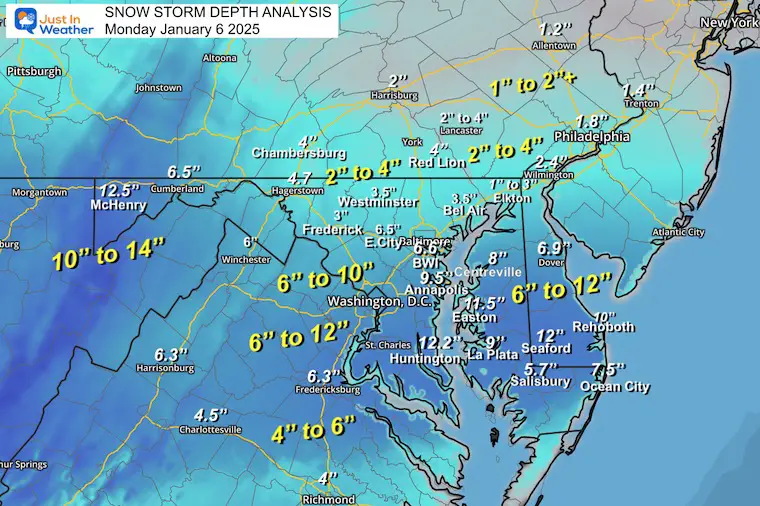
January 6 Snow Report
Previous Snow
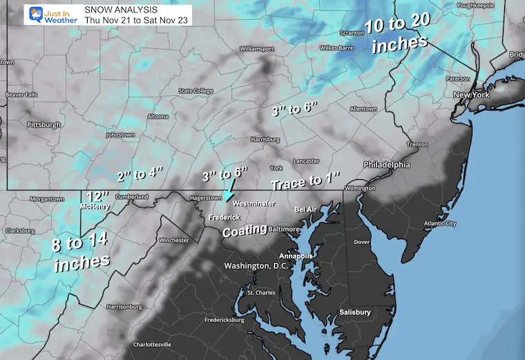
November 22 Snow Report
Subscribe for eMail Alerts
Weather posts straight to your inbox
Sign up and be the first to know!
ALSO SEE
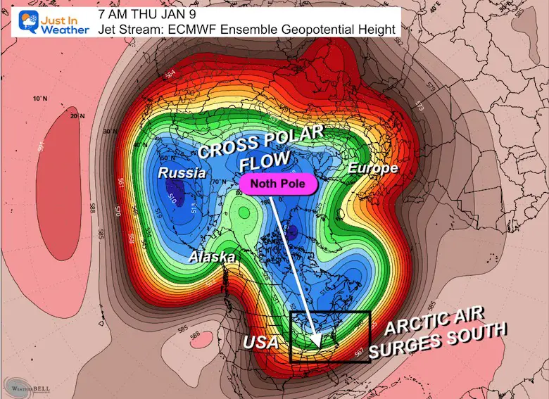
Arctic Outbreak For January
If you missed it, here is my detailed report from December 30 about why this IS A BIG DEAL!
MY WINTER OUTLOOK
FITF Gear on Sale
In Case You Missed This
The Faith In The Flakes Dec 5 Origin Story
Please share your thoughts and best weather pics/videos, or just keep in touch via social media.
-
Facebook: Justin Berk, Meteorologist
-
Twitter
-
Instagram
SCHEDULE A WEATHER BASED STEM ASSEMBLY
Severe Weather: Storm Smart October and next spring Winter Weather FITF (Faith in the Flakes): November To March Click to see more and send a request for your school.
THANK YOU:
Baltimore Magazine Readers Choice Best Of Baltimore
Maryland Trek 11 Day 7 Completed Sat August 10
We raised OVER $104,000 for Just In Power Kids – AND Still Collecting More
The annual event: Hiking and biking 329 miles in 7 days between The Summit of Wisp to Ocean City.
Each day, we honor a kid and their family’s cancer journey.
Fundraising is for Just In Power Kids: Funding Free Holistic Programs. I never have and never will take a penny. It is all for our nonprofit to operate.
Click here or the image to donate:
RESTATING MY MESSAGE ABOUT DYSLEXIA
I am aware there are some spelling and grammar typos and occasional other glitches. I take responsibility for my mistakes and even the computer glitches I may miss. I have made a few public statements over the years, but if you are new here, you may have missed it: I have dyslexia and found out during my second year at Cornell University. It didn’t stop me from getting my meteorology degree and being the first to get the AMS CBM in the Baltimore/Washington region. One of my professors told me that I had made it that far without knowing and to not let it be a crutch going forward. That was Mark Wysocki, and he was absolutely correct! I do miss my mistakes in my own proofreading. The autocorrect spell check on my computer sometimes does an injustice to make it worse. I also can make mistakes in forecasting. No one is perfect at predicting the future. All of the maps and information are accurate. The ‘wordy’ stuff can get sticky. There has been no editor who can check my work while writing and to have it ready to send out in a newsworthy timeline. Barbara Werner is a member of the web team that helps me maintain this site. She has taken it upon herself to edit typos when she is available. That could be AFTER you read this. I accept this and perhaps proves what you read is really from me… It’s part of my charm. #FITF


