January 14 2025
Tuesday Morning Report
Colder air is back, along with gusty winds, for a few days. We may see flurries tonight and again later on Thursday.
Mild air this weekend may bring rain showers, but the Polar Vortex outlook will be a major factor in our arctic plunge next week. Light snow may develop Sunday night as the coldest air of the season arrives next week.
Last Night’s Sky Snow
The Moon and Mars Occultation was captured by James Wilinghan
CLIMATE DATA: Baltimore
TODAY January 14
Sunrise at 7:25 AM
Sunset at 5:07 PM
Normal Low in Baltimore: 25ºF
Record -2ºF in 1912
Normal High in Baltimore: 43ºF
Record 79ºF 1932
Baltimore Drought Update
8.00 Inch Deficit For 2024
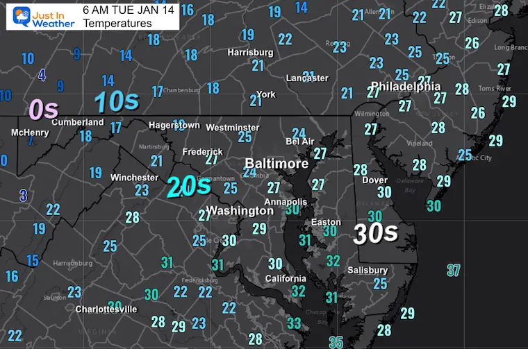
Morning Temperatures
The leading edge of this new push of cold air is showing up already…
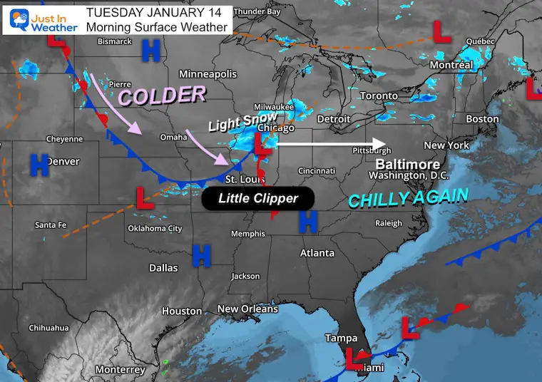
Morning Surface Weather
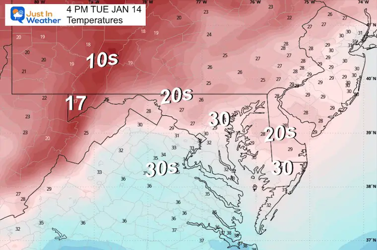
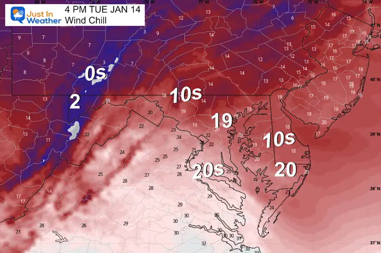
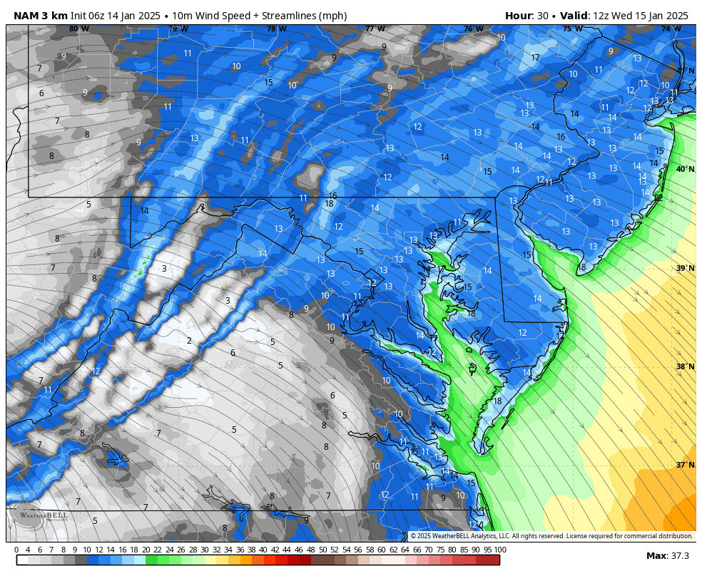
We are back into the chilly air, and winds will be increasing.
A little clipper will be racing east and will only bring us flurries tonight.
Weather Simulation Tuesday To Thursday
A few pushes of colder air will bring flurries tonight and a larger push of flurries or light snow on Thursday.
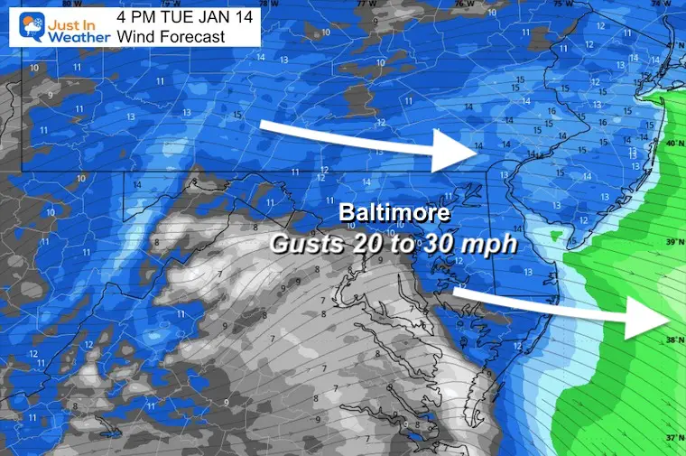
Afternoon Winds
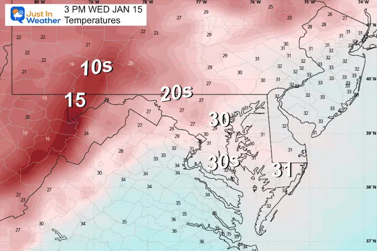
Afternoon Temperatures
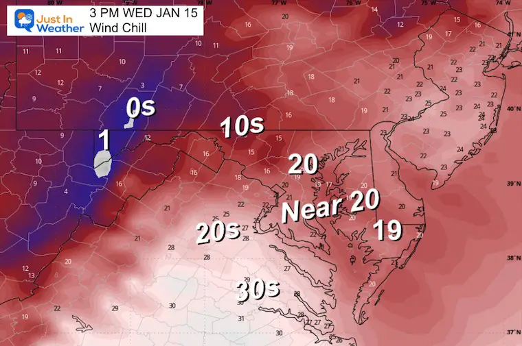
Afternoon Wind Chills
Wednesday Weather
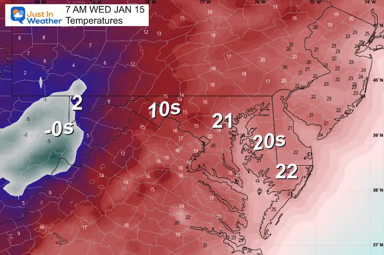
Morning Temperatures
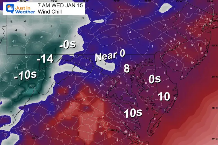
Morning Wind Chills
Wind Forecast 7 AM to Midnight
Strong winds will kick up as a new cold airmass builds in.
Afternoon Temperatures
Afternoon Wind Chills
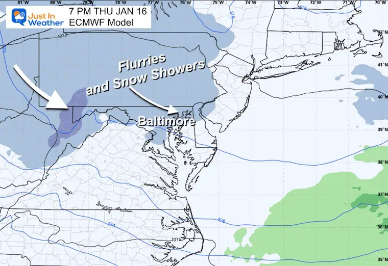
Thursday Evening
One more impulse may bring flurries or light snow.
Weekend Outlook
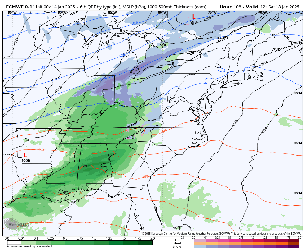
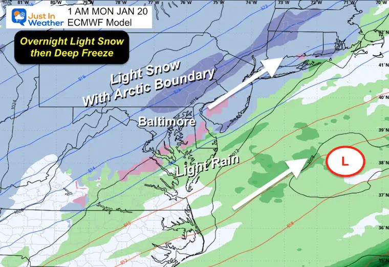
We will get a surge of mild air with rain showers just ahead of the Arctic boundary. As the leading edge of that air mass arrives, there is still a hint of snow (light) breaking out Sunday night into Monday morning.
Saturday to Monday
Rain showers, then a band of light snow with a Low forming off the coast.
Sunday Overnight
Suggestion not a promise of light snow breaking out as the arctic air moves in… There will be some adjustments… but there has been a consistent outlook of some type of event in the transition.
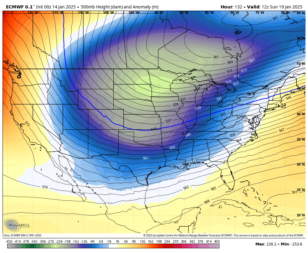
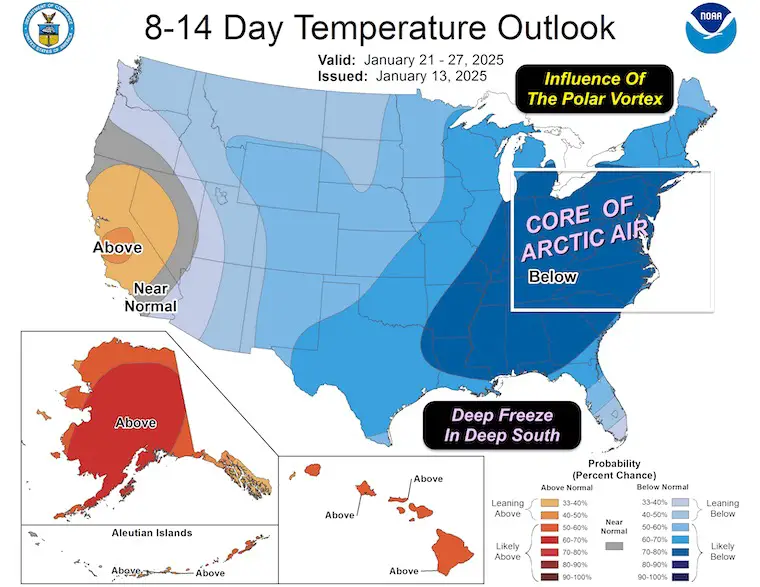
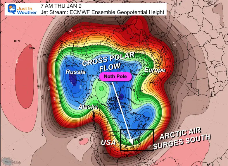
LONG RANGE OUTLOOK
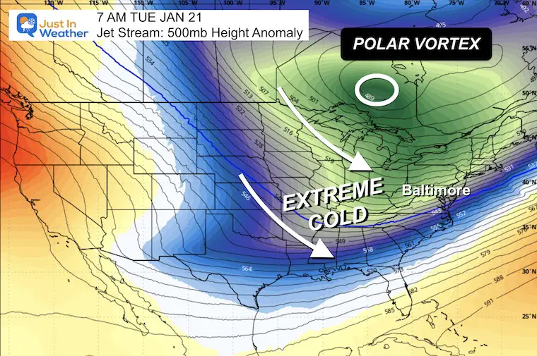
The Polar Vortex may skim the US and Canadian border. It will influence the very cold push all the way down to the Gulf Coast with a deep freeze.
Jet Stream Animation: Sun Jan 19 to Fri Jan 24
Snapshot Tue Jan 21
The Polar Vortex Influence will bring the coldest air of the season across the Great Lakes and Ohio Valley… our way.
Arctic Air ‘Suggestion’
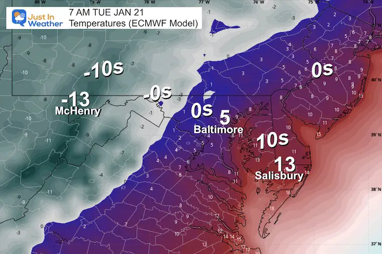
Tuesday Morning Temps: Eastern US
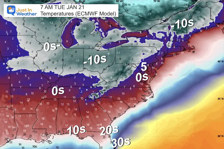
Tuesday Morning Temps: Mid-Atlantic
NOAA Temperature Outlook
Valid Jan 21 to Jan 27
7 Day Forecast
After a few windy and colder days, there will be another brief warm-up this weekend, followed by the leading edge of the Arctic air mass that will hit us next week.

Subscribe for eMail Alerts
SNOW REPORTS THIS SEASON
Click on the maps for that full report.
January 11 Snow Report

January 6 Snow Report

Previous Snow

ALSO SEE
Arctic Outbreak For January
If you missed it, here is my detailed report from December 30 about why this IS A BIG DEAL!
MY WINTER OUTLOOK
My Winter Outlook Report

FITF Gear on Sale

In Case You Missed This
The Faith In The Flakes Dec 5 Origin Story

Please share your thoughts and best weather pics/videos, or just keep in touch via social media.
SCHEDULE A WEATHER BASED STEM ASSEMBLY
Severe Weather: Storm Smart October and next spring Winter Weather FITF (Faith in the Flakes): November To March Click to see more and send a request for your school.

THANK YOU:
Baltimore Magazine Readers Choice Best Of Baltimore
Maryland Trek 11 Day 7 Completed Sat August 10
We raised OVER $104,000 for Just In Power Kids – AND Still Collecting More
The annual event: Hiking and biking 329 miles in 7 days between The Summit of Wisp to Ocean City.
Each day, we honor a kid and their family’s cancer journey.
Fundraising is for Just In Power Kids: Funding Free Holistic Programs. I never have and never will take a penny. It is all for our nonprofit to operate.
Click here or the image to donate:

RESTATING MY MESSAGE ABOUT DYSLEXIA
I am aware there are some spelling and grammar typos and occasional other glitches. I take responsibility for my mistakes and even the computer glitches I may miss. I have made a few public statements over the years, but if you are new here, you may have missed it: I have dyslexia and found out during my second year at Cornell University. It didn’t stop me from getting my meteorology degree and being the first to get the AMS CBM in the Baltimore/Washington region. One of my professors told me that I had made it that far without knowing and to not let it be a crutch going forward. That was Mark Wysocki, and he was absolutely correct! I do miss my mistakes in my own proofreading. The autocorrect spell check on my computer sometimes does an injustice to make it worse. I also can make mistakes in forecasting. No one is perfect at predicting the future. All of the maps and information are accurate. The ‘wordy’ stuff can get sticky. There has been no editor who can check my work while writing and to have it ready to send out in a newsworthy timeline. Barbara Werner is a member of the web team that helps me maintain this site. She has taken it upon herself to edit typos when she is available. That could be AFTER you read this. I accept this and perhaps proves what you read is really from me… It’s part of my charm. #FITF


