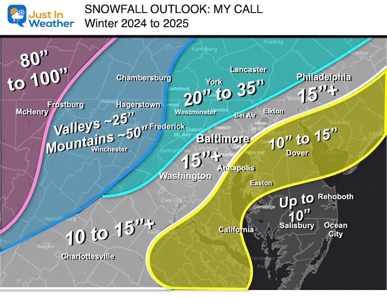
January 11 Snow Reports And Grade My Forecast
Saturday January 11 2025
The southern storm system that passed through our region brought snow late Friday night and ended before sunrise on Saturday. For the most part, this system behaved as expected, with some subtle differences. In this report, I just want to give a brief recap of the event and compare my forecast to the actual snow reports.
Official Station Reports
- Baltimore at BWI = 1.5”; Season Total = 8.1”
- Washington at Regan National = 0.7”
- Washington at Dulles Airport = 1.8”
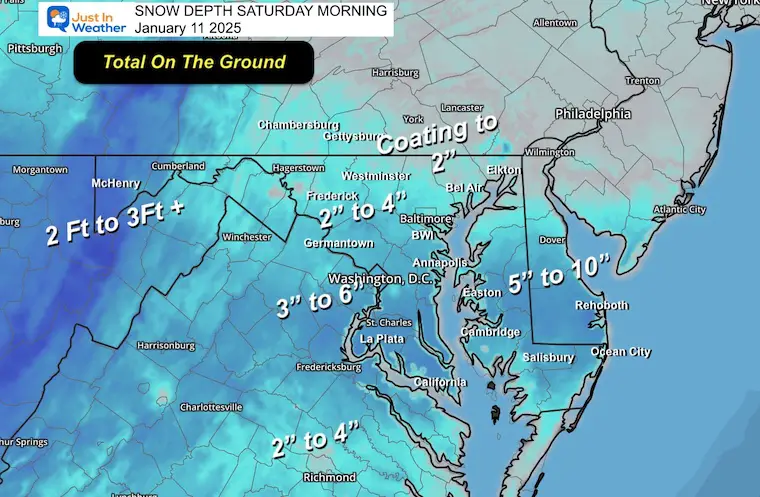
Snow Depth Saturday Morning
This includes snow already on the ground since the first snowstorm on Monday. The mountains have had a very plentiful start to the new year, with over three feet of snow in spots.
The maps of new snow totals from this event, along with a list of local spotters, are below.
Headlines
- Timing expectations sped up a few days prior, resulting in an overnight event. This also led to it ending sooner, limiting the impact on Saturday events.
- Snow totals ended up on the top end or even overachieving.
- I made two adjustments to the snowfall:
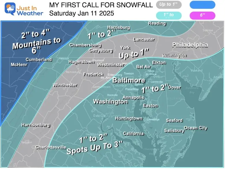
- My initial snow forecast was pretty close to the final results. I did drop my numbers with the anticipation of dry air and the farthest south track by ECMWF.
- My final forecast before the first flakes on Friday brought the snow totals up higher.
- My Grade: I give my work an A-. Overall, this worked out well. The main execution was the slight fluctuation between ‘up to 1 inch’ vs. ‘1 to 2 inches’. Some areas did surpass that between Montgomery, Howard, and into Northern Baltimore and Harford Counties.
Please review the report, then go back to the social media page where you found this and grade my work on this storm.
Alerts
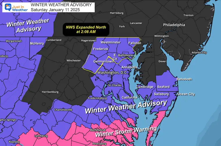
The National Weather Service kept expanding the Winter Weather Advisory to the north. The first Winter Storm Watch, then upgraded to Winter Weather Advisory, was for Southern Maryland.
The first adjustment was Friday afternoon.. to include metro Washington DC and Annapolis.
The final adjustment (see here) came at 2:08 AM to include more of Central Maryland around Baltimore. This may not have helped most people who were sleeping, but it was related to the 1 inch snow totals.
Final Winter Weather Advisory MAP
Computer Models
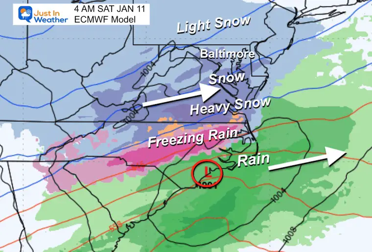
While this had been expected to stay to our south, there was once again a spit in the computer guidance. The European ECWMF Model remains the winning medium-range forecast model. It was most consistent; however, the nod to slightly higher totals goes to the GFS Model. This was also picked up on by the short-range high-resolution models NAM 3 Km and HRRR.
My Call For Snowfall
THREE MAPS FOR POSTERITY: Final to Initial
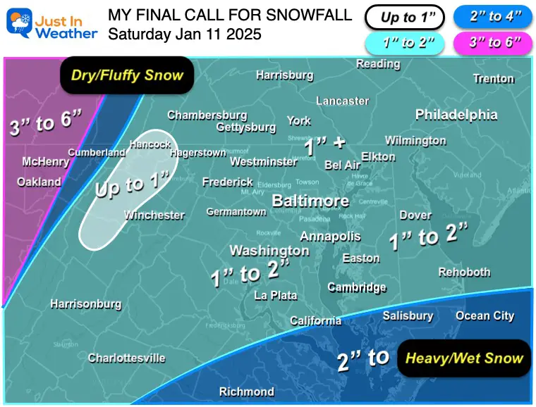
My Final Call For Snowfall
This brought my expectation for most of the region in the 1 to 2-inch range across Central Maryland, with 1”+ near the line and into Southern Pennsylvania.
Southern Maryland was in my 2 to 4-inch range.
The mountains were in my 3 to 6-inch snowfall…. Note they are still getting snow as of this report.
Prior Forecast Maps
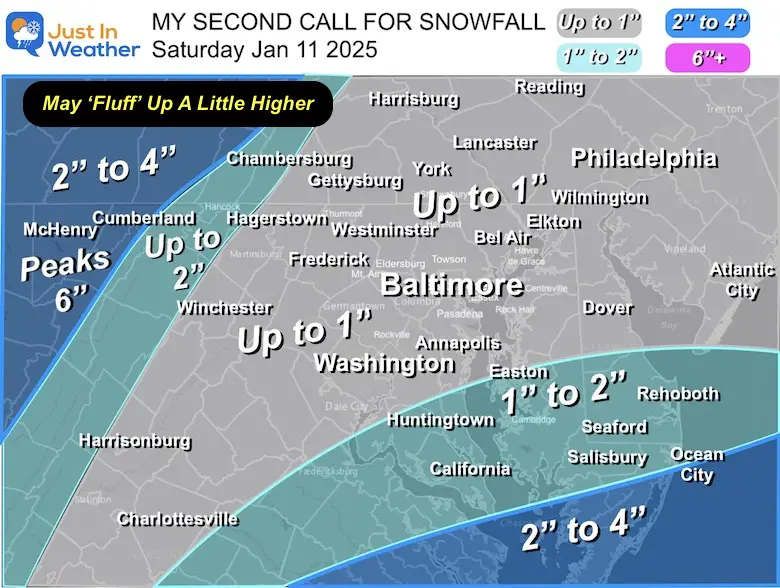
My Second Call – Issued Thursday
I lowered my expectations by suggested the fluffy snow may make for higher amounts.
My First Call – Issued Wednesday
Snow Spotter Maps
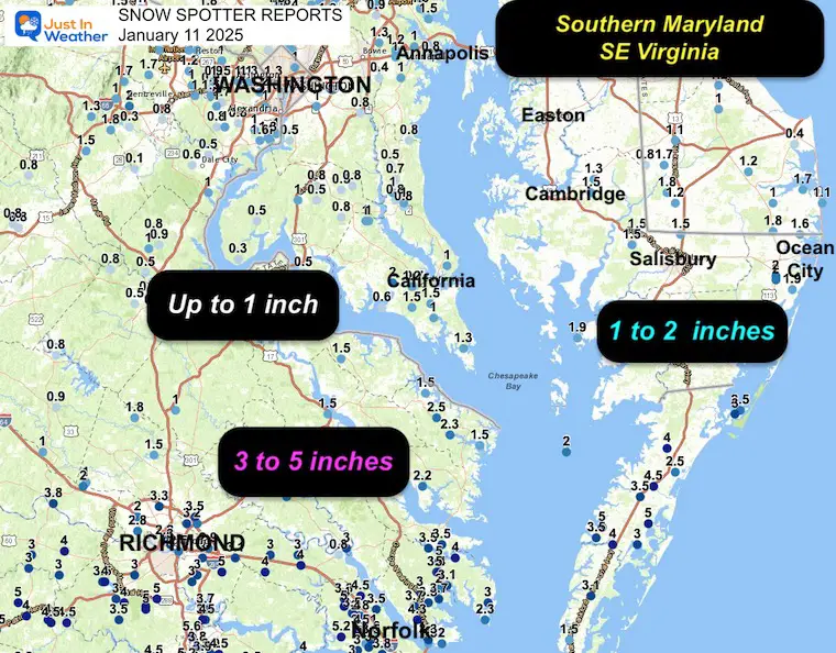
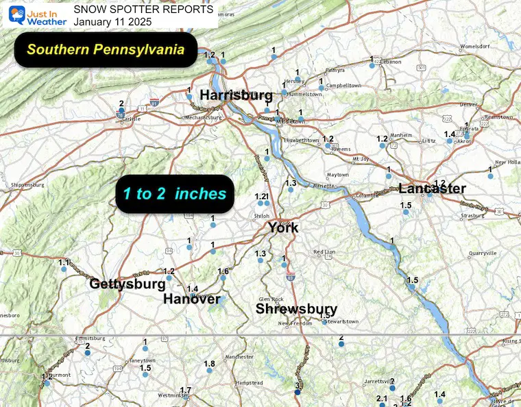
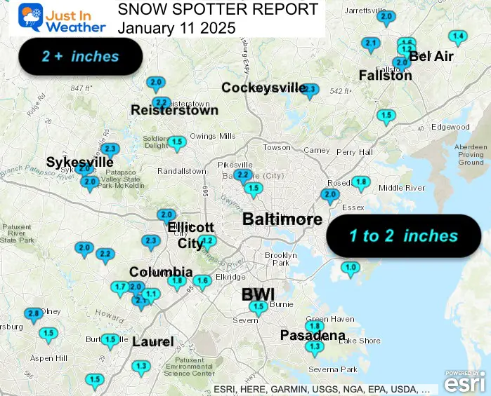
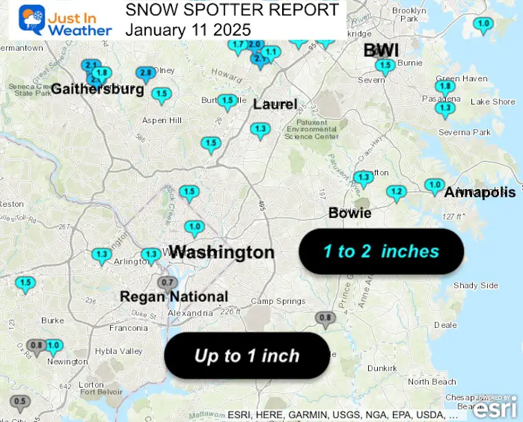
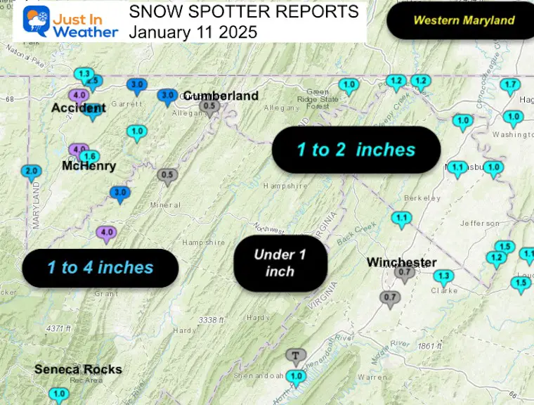
These three maps are across the region, followed by more local maps for Maryland from NWS Baltimore, Washington. A list per county can be seen below as well.
Maryland and Virginia
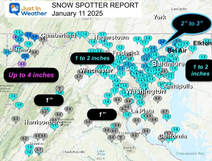
Central Maryland
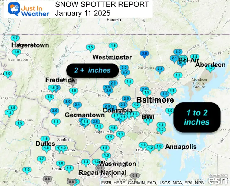
Delmarva and Southeast Virginia
Southern Pennsylvania
Local Maryland Maps
Central Maryland
Washington/Annapolis
Western Maryland
Snow Spotter List:
DISTRICT OF COLUMBIA
- Catholic University 1.0 421 AM 1/11 NWS Employee
MARYLAND
…Allegany County…
- Bellegrove 1 SSE 1.0 826 AM 1/11 Trained Spotter
- Frostburg 0.7 700 AM 1/11 Co-Op Observer
- Potomac Park 2 NW 0.5 1039 AM 1/11 Dept of Highways
- Cumberland 0.3 700 AM 1/11 Co-Op Observer
…Anne Arundel County…
Green Haven 1 ESE 1.8 710 AM 1/11 Trained Spotter
Arnold 2 N 1.5 800 AM 1/11 CoCoRaHS
Severn 2 SSW 1.5 1037 AM 1/11 CoCoRaHS
Baltmore-Washington 1.5 500 AM 1/11 Dept of Highways
Severn 2 W 1.5 845 AM 1/11 Public
Bwi Airport 1.3 700 AM 1/11 Official NWS Obs
Severn 1 SSE 1.3 800 AM 1/11 CoCoRaHS
Chelsea Beach 1.3 717 AM 1/11 Trained Spotter
Crofton 1 SSE 1.3 549 AM 1/11 NWS Employee
Crownsville 3 SSW 1.2 730 AM 1/11 Trained Spotter
Glen Burnie 1 WSW 1.2 844 AM 1/11 Trained Spotter
Parole 1.0 500 AM 1/11 Dept of Highways
Birdsville WSW 1.0 700 AM 1/11 CoCoRaHS
Riva 2 WNW 1.0 900 AM 1/11 Trained Spotter
Odenton 1 N 0.9 600 AM 1/11 CoCoRaHS
Annapolis 1 SE 0.8 806 AM 1/11 CoCoRaHS
…Baltimore County…
- Bentley Springs 6 S 3.0 500 AM 1/11 Dept of Highways
- Long Green 2 NW 2.3 800 AM 1/11 Trained Spotter
- Glyndon 1 WSW 2.2 700 AM 1/11 Trained Spotter
- Rosedale 1 E 2.0 500 AM 1/11 Dept of Highways
- Reistertown 2 NW 2.0 757 AM 1/11 Co-Op Observer
- Long Green 1 SW 2.0 700 AM 1/11 CoCoRaHS
- Randallstown 2 NW 1.8 907 AM 1/11 Trained Spotter
- Towson 1 SW 1.8 830 AM 1/11 CoCoRaHS
- Middle River 1 N 1.8 400 AM 1/11 Trained Spotter
- Fullerton 1 N 1.8 1015 AM 1/11 Trained Spotter
- White Marsh 2 ESE 1.5 700 AM 1/11 CoCoRaHS
- Upper Falls 1 NNE 1.5 645 AM 1/11 Trained Spotter
- Owings Mills 1.5 500 AM 1/11 Dept of Highways
- Kingsville 1 E 1.5 700 AM 1/11 CoCoRaHS
- Catonsville 1.2 130 AM 1/11 Public
- Edgemere SE 1.0 752 AM 1/11 Trained Spotter
…Baltimore City…
- Mount Washington 1 N 2.3 845 AM 1/11 CoCoRaHS
- Pimlico SE 2.2 619 AM 1/11 Trained Spotter
- Arlington 2 ESE 1.5 346 AM 1/11 Broadcast Media
…Calvert County…
- Dowell 2 NE 1.0 920 AM 1/11 Trained Spotter
- Prince Frederick 1 S 1.0 500 AM 1/11 Dept of Highways
- Prince Frederick 1 W 0.8 800 AM 1/11 CoCoRaHS
- Huntingtown SW 0.7 810 AM 1/11 Trained Spotter
- Huntingtown 3 NNW 0.5 700 AM 1/11 CoCoRaHS
…Carroll County…
- Eldersburg 1 SE 2.3 456 AM 1/11 Trained Spotter
- Eldersburg 1 E 2.3 700 AM 1/11 CoCoRaHS
- Sykesville 1 NNW 2.0 716 AM 1/11 NWS Employee
- Mount Airy SE 2.0 700 AM 1/11 CoCoRaHS
- Westminster 6 NE 1.8 504 AM 1/11 Public
- Gamber 1 WNW 1.7 952 AM 1/11 NWS Employee
- Westminster SE 1.7 830 AM 1/11 Trained Spotter
- Westminster 3 SSW 1.5 700 AM 1/11 CoCoRaHS
- Uniontown 3 N 1.5 630 AM 1/11 Trained Spotter
- Taneytown 4 NE 1.0 800 AM 1/11 CoCoRaHS
…Cecil County…
- Elkton 2 W 1.2 500 AM 1/11 Dept of Highways
- Galena 4 NW 1.2 900 AM 1/11 Cocorahs
- Elkton 1 NNW 1.0 800 AM 1/11 CoCoRaHS
- Elkton 5 NW 0.8 700 AM 1/11 CoCoRaHS
…Charles County…
- La Plata 2 NNW 1.0 500 AM 1/11 Dept of Highways
- Waldorf 3 S 0.8 800 AM 1/11 CoCoRaHS
- Charlotte Hall 2 NW 0.8 600 AM 1/11 Trained Spotter
- Welcome 2 WNW 0.5 705 AM 1/11 Trained Spotter
- La Plata 3 ENE 0.5 645 AM 1/11 Trained Spotter
- Tompkinsville 4 WNW 0.5 550 AM 1/11 Trained Spotter
- Bryantown 2 NE 0.5 700 AM 1/11 CoCoRaHS
- Nanjemoy 5 S 0.3 700 AM 1/11 CoCoRaHS
…Frederick County…
- Emmitsburg 2 SE 2.0 730 AM 1/11 Co-Op Observer
- Ballenger Creek 1 E 2.0 500 AM 1/11 Dept of Highways
- New Market 2 NW 1.8 800 AM 1/11 Trained Spotter
- Point of Rocks 1 NE 1.7 925 AM 1/11 Trained Spotter
- Ballenger Creek WSW 1.6 700 AM 1/11 Trained Spotter
- Green Valley 1 WNW 1.5 723 AM 1/11 Public
- Adamstown 1 ESE 1.5 600 AM 1/11 NWS Employee
- Middletown 1.5 700 AM 1/11 CoCoRaHS
- Thurmont 1 SSE 1.2 700 AM 1/11 CoCoRaHS
- Lewistown 2 SSW 1.2 920 AM 1/11 Trained Spotter
- Frederick 3 N 1.2 820 AM 1/11 CoCoRaHS
- New Market 2 N 0.8 1230 AM 1/11 Trained Spotter
…Garrett County…
- Mc Henry 4 SE 4.0 1033 AM 1/11 Park/Forest Srvc
- Accident 3 NNE 4.0 1035 AM 1/11 Dept of Highways
- Frostburg 3 WNW 3.0 1030 AM 1/11 Trained Spotter
- Grantsville 4 E 3.0 1036 AM 1/11 Dept of Highways
- Grantsville 5 W 2.5 500 AM 1/11 Dept of Highways
- Accident 4 E 2.2 1000 AM 1/11 Public
- Oakland 5 NW 2.0 830 AM 1/11 Trained Spotter
- Deer Park 6 NE 1.6 1000 AM 1/11 Trained Spotter
- Grantsville 7 WNW 1.3 930 AM 1/11 Trained Spotter
- McHenry 5 SSE 1.0 800 AM 1/11 CoCoRaHS
- Barton 1.0 1023 AM 1/11 Law Enforcement
…Harford County…
- Forest Hill 3 SW 2.1 730 AM 1/11 Trained Spotter
- Forest Hill 1 NNW 2.0 800 AM 1/11 Trained Spotter
- Bel Air 2 W 2.0 700 AM 1/11 CoCoRaHS
- Norrisville 1 WSW 2.0 645 AM 1/11 CoCoRaHS
- Bel Air 2.0 457 AM 1/11 Trained Spotter
- Chrome Hill 2 SE 2.0 800 AM 1/11 CoCoRaHS
- Bynum 1 E 1.6 709 AM 1/11 Trained Spotter
- Churchville 1 N 1.4 751 AM 1/11 Trained Spotter
- Aberdeen Proving Gro 1.3 424 AM 1/11 Trained Spotter
- Bel Air 1 N 1.2 400 AM 1/11 Trained Spotter
…Howard County…
- Ellicott City 1 SW 2.3 805 AM 1/11 Trained Spotter
- Clarksville 2 N 2.2 330 AM 1/11 Trained Spotter
- Ellicott City 2.2 925 AM 1/11 Broadcast Media
- Simpsonville 1 SSE 2.1 400 AM 1/11 Trained Spotter
- Simpsonville E 2.1 1015 AM 1/11 Trained Spotter
- Simpsonville 2.0 435 AM 1/11 Trained Spotter
- Dayton 1 NE 2.0 500 AM 1/11 Dept of Highways
- Ellicott City 2 NE 2.0 133 AM 1/11 Public
- Sykesville 2 SSE 2.0 700 AM 1/11 CoCoRaHS
- Elkridge 2 W 1.8 700 AM 1/11 CoCoRaHS
- Columbia 2 NNW 1.7 841 AM 1/11 CoCoRaHS
- Simpsonville 1 W 1.7 700 AM 1/11 Trained Spotter
- Columbia 2 N 1.6 700 AM 1/11 CoCoRaHS
- Elkridge 1.6 824 AM 1/11 NWS Employee
- Columbia 1.5 700 AM 1/11 NWS Employee
- Columbia 3 SSE 1.5 700 AM 1/11 CoCoRaHS
- Historic Ellicott Ci 1.5 832 AM 1/11 NWS Employee
- North Laurel 2 ESE 1.4 700 AM 1/11 CoCoRaHS
- Sykesville 3 SE 1.4 700 AM 1/11 CoCoRaHS
- Columbia 2 SSE 1.1 120 AM 1/11 Broadcast Media
- Laurel 1 NNE 1.0 800 AM 1/11 CoCoRaHS
…Montgomery County…
- Olney 2.8 700 AM 1/11 Trained Spotter
- Washington Grove 1 N 2.5 715 AM 1/11 Trained Spotter
- Laytonsville 5 NNW 2.3 700 AM 1/11 CoCoRaHS
- Damascus 1 S 2.3 700 AM 1/11 CoCoRaHS
- Montgomery Village 1 2.1 700 AM 1/11 CoCoRaHS
- Damascus 3 SSW 2.1 200 AM 1/11 Co-Op Observer
- Montgomery Village 2 2.1 245 AM 1/11 Trained Spotter
- Dickerson 2.0 756 AM 1/11 Emergency Mngr
- Clarksburg 4 NNW 2.0 756 AM 1/11 Emergency Mngr
- Montgomery Village 1 2.0 630 AM 1/11 CoCoRaHS
- Olney 1 ENE 2.0 800 AM 1/11 CoCoRaHS
- Gaithersburg 2 E 2.0 700 AM 1/11 CoCoRaHS
- Gaithersburg 3 NE 1.8 800 AM 1/11 CoCoRaHS
- Norbeck 1 ESE 1.8 700 AM 1/11 CoCoRaHS
- Potomac 3 NE 1.8 700 AM 1/11 CoCoRaHS
- Montgomery Village 3 1.8 100 AM 1/11 Trained Spotter
- Potomac 1 NNW 1.7 700 AM 1/11 CoCoRaHS
- Colesville 2 W 1.6 700 AM 1/11 CoCoRaHS
- Calverton 1 SW 1.5 500 AM 1/11 Dept of Highways
- Norbeck 2 NE 1.5 149 AM 1/11 Public
- Burtonsville 1.5 756 AM 1/11 Emergency Mngr
- Takoma Park 1.5 756 AM 1/11 Emergency Mngr
- Takoma Park 1 NNW 1.5 700 AM 1/11 CoCoRaHS
- Silver Spring 6 NNE 1.4 528 AM 1/11 CoCoRaHS
- Wheaton 1 NW 1.4 930 AM 1/11 Trained Spotter
- Laytonsville 2 WNW 1.3 855 AM 1/11 Trained Spotter
- Poolesville 1.1 330 AM 1/11 Trained Spotter
- White Oak 1 N 1.0 700 AM 1/11 CoCoRaHS
- Chevy Chase 1 SW 0.9 700 AM 1/11 CoCoRaHS
…Prince Georges County…
- Beltsville 1 NNW 1.5 830 AM 1/11 CoCoRaHS
- West Laurel 1 N 1.4 800 AM 1/11 CoCoRaHS
- Laurel 2 SSW 1.3 145 AM 1/11 Trained Spotter
- Greenbelt 1 N 1.1 700 AM 1/11 CoCoRaHS
- Suitland 2 SE 1.0 700 AM 1/11 CoCoRaHS
- Upper Marlboro 1 S 0.8 500 AM 1/11 Dept of Highways
- Fort Washington 1 SS 0.5 700 AM 1/11 CoCoRaHS
- Upper Marlboro 7 NE 0.4 700 AM 1/11 CoCoRaHS
…St. Marys County…
- Leonardtown 1 NE 2.0 600 AM 1/11 CoCoRaHS
- Callaway 2 W 1.5 147 AM 1/11 Trained Spotter
- Great Mills 1 NNE 1.5 937 AM 1/11 Trained Spotter
- Ridge 1 N 1.3 700 AM 1/11 CoCoRaHS
- Hollywood 3 S 1.2 815 AM 1/11 Trained Spotter
- Great Mills 4 S 1.0 800 AM 1/11 CoCoRaHS
- California 3 W 0.7 800 AM 1/11 Trained Spotter
- Compton 3 SSE 0.6 800 AM 1/11 Trained Spotter
…Washington County…
- Maugansville WSW 1.7 700 AM 1/11 Trained Spotter
- Boonsboro 3 NNE 1.7 600 AM 1/11 Trained Spotter
- Hagerstown 4 NNW 1.7 700 AM 1/11 CoCoRaHS
- Hagerstown 1 ENE 1.3 700 AM 1/11 CoCoRaHS
- Pecktonville 3 NNW 1.2 815 AM 1/11 NWS Employee
- Hancock 1 ESE 1.2 800 AM 1/11 Trained Spotter
- Williamsport 3 ENE 1.1 600 AM 1/11 CoCoRaHS
- Hagerstown 3 S 1.0 800 AM 1/11 CoCoRaHS
- Funkstown 2 WSW 1.0 500 AM 1/11 Dept of Highways
Southern Pennsylvania
…Adams County…
- New Oxford 0.8 SE 1.2 in 0730 AM 01/11 COCORAHS
- Cashtown 1 S 1.1 in 0700 AM 01/11 COOP
- Abbottstown 2.4 N 1.0 in 0800 AM 01/11 COCORAHS
- York Springs 2.5 N 0.6 in 0700 AM 01/11 COCORAHS
…Lancaster County…
- Holtwood 1.5 in 0700 AM 01/11 COOP
- Millersville 1 S 1.5 in 0700 AM 01/11 COOP
- Millersville 1.5 in 0745 AM 01/11 Trained Spotter
- 1 WSW Akron 1.4 in 0830 AM 01/11 Public
- 1 E Lancaster 1.3 in 0716 AM 01/11 Public
- 1 ESE Elizabethtown 1.2 in 0700 AM 01/11 Public
- 3 ENE Lancaster 1.2 in 0700 AM 01/11 Public
- 2 SW Manheim 1.2 in 0810 AM 01/11 Trained Spotter
- Landisville 1.2 ESE 1.0 in 0700 AM 01/11 COCORAHS
- Safe Harbor 1.0 in 0700 AM 01/11 COOP
- Ephrata 0.9 E 1.0 in 0730 AM 01/11 COCORAHS
- New Holland 1.4 SSW 1.0 in 0753 AM 01/11 COCORAHS
- 1 SSE Ephrata 1.0 in 0820 AM 01/11 Trained Spotter
…York County…
- 2 SW Spring Grove 1.6 in 0415 AM 01/11 Trained Spotter
- Stewartstown 0.5 S 1.5 in 0819 AM 01/11 COCORAHS
- Hanover 1.4 in 0315 AM 01/11 Trained Spotter
- Mount Wolf 1.0 SE 1.3 in 0700 AM 01/11 COCORAHS
- 1 SE New Salem 1.3 in 0825 AM 01/11 Trained Spotter
- 3 WNW Emigsville 1.2 in 0745 AM 01/11 Trained Spotter
- East Berlin 3.4 ESE 1.0 in 0600 AM 01/11 COCORAHS
- Jacobus 1.0 in 0635 AM 01/11 Trained Spotter
- York 4.2 NNW 1.0 in 0700 AM 01/11 COCORAHS
- Dover 4.2 WSW 1.0 in 0715 AM 01/11 COCORAHS
- York Haven 2.3 WNW 1.0 in 0800 AM 01/11 COCORAHS
- Valley Green 0.9 in 0655 AM 01/11 Public
- Valley Green 0.8 ENE 0.9 in 0700 AM 01/11 COCORAHS
Mountain Snow
There has been epic snowfall across the larger ski resorts in the last week. They will continue to get more.
Subscribe for eMail Alerts
Weather posts straight to your inbox
Sign up and be the first to know!
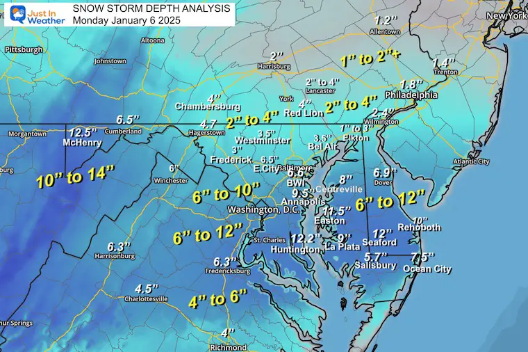
January 6 Snow Report
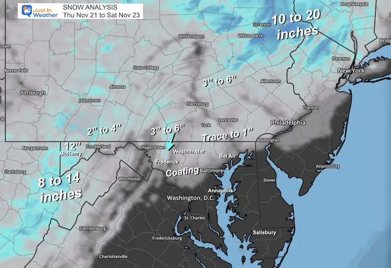
Previous Snow
November 22 Snow Report
ALSO SEE
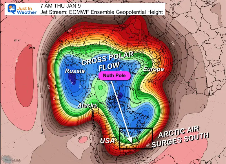
Arctic Outbreak For January
If you missed it, here is my detailed report from December 30 about why this IS A BIG DEAL!
MY WINTER OUTLOOK
FITF Gear on Sale
In Case You Missed This
The Faith In The Flakes Dec 5 Origin Story
Please share your thoughts and best weather pics/videos, or just keep in touch via social media.
-
Facebook: Justin Berk, Meteorologist
-
Twitter
-
Instagram
SCHEDULE A WEATHER BASED STEM ASSEMBLY
Severe Weather: Storm Smart October and next spring Winter Weather FITF (Faith in the Flakes): November To March Click to see more and send a request for your school.
THANK YOU:
Baltimore Magazine Readers Choice Best Of Baltimore
Maryland Trek 11 Day 7 Completed Sat August 10
We raised OVER $104,000 for Just In Power Kids – AND Still Collecting More
The annual event: Hiking and biking 329 miles in 7 days between The Summit of Wisp to Ocean City.
Each day, we honor a kid and their family’s cancer journey.
Fundraising is for Just In Power Kids: Funding Free Holistic Programs. I never have and never will take a penny. It is all for our nonprofit to operate.
Click here or the image to donate:
RESTATING MY MESSAGE ABOUT DYSLEXIA
I am aware there are some spelling and grammar typos and occasional other glitches. I take responsibility for my mistakes and even the computer glitches I may miss. I have made a few public statements over the years, but if you are new here, you may have missed it: I have dyslexia and found out during my second year at Cornell University. It didn’t stop me from getting my meteorology degree and being the first to get the AMS CBM in the Baltimore/Washington region. One of my professors told me that I had made it that far without knowing and to not let it be a crutch going forward. That was Mark Wysocki, and he was absolutely correct! I do miss my mistakes in my own proofreading. The autocorrect spell check on my computer sometimes does an injustice to make it worse. I also can make mistakes in forecasting. No one is perfect at predicting the future. All of the maps and information are accurate. The ‘wordy’ stuff can get sticky. There has been no editor who can check my work while writing and to have it ready to send out in a newsworthy timeline. Barbara Werner is a member of the web team that helps me maintain this site. She has taken it upon herself to edit typos when she is available. That could be AFTER you read this. I accept this and perhaps proves what you read is really from me… It’s part of my charm. #FITF


