Sunday Night January 5 2025
It has been three years since a single storm dropped over 6 inches of snow on metro areas. This one on the way is likely to surpass that, ending our drought for Baltimore and Washington. The core of the heavy snow is expected to cross over these cities and toward the coast.
I made some minor adjustments to my forecast map, mainly just on the edges. The southern part of our region will see more, verifying the European Model again. The northern part will see less, as very cold and dry air from New England is forcing this storm on its due east path.
Below is a new timeline for the arrival and expectations for Monday.
The cold, dry air is likely to produce dry snow that will be easier to shovel. This is factored in with fluffing up the totals.
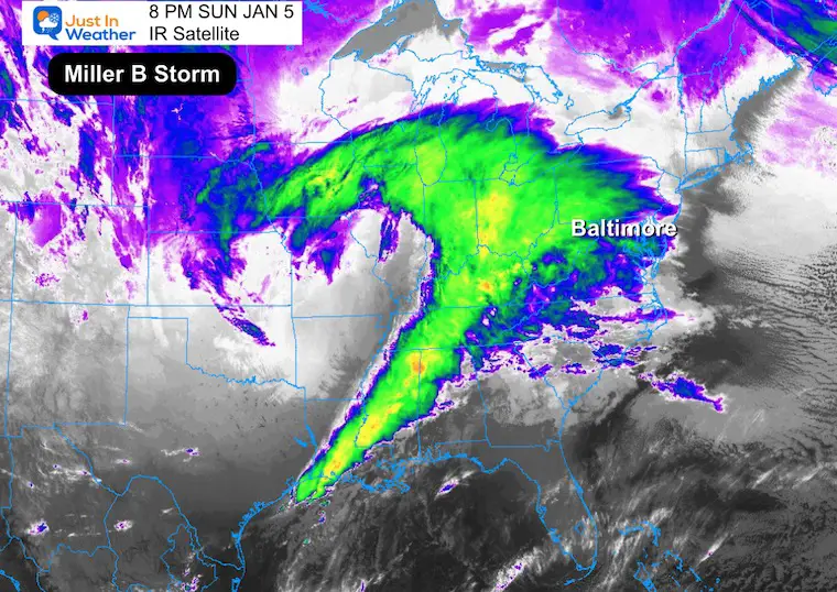
Sunday Night Satellite
This Infrared view shows a classic comma shape for this powerful storm. It has produced thunder snow and blizzard conditions, along with heavy icing and severe thunderstorms along its path.
This is a Miller B Storm that will transfer energy to the coast tomorrow for a new Low Pressure.
Satellite Loop 6 PM to 8 PM
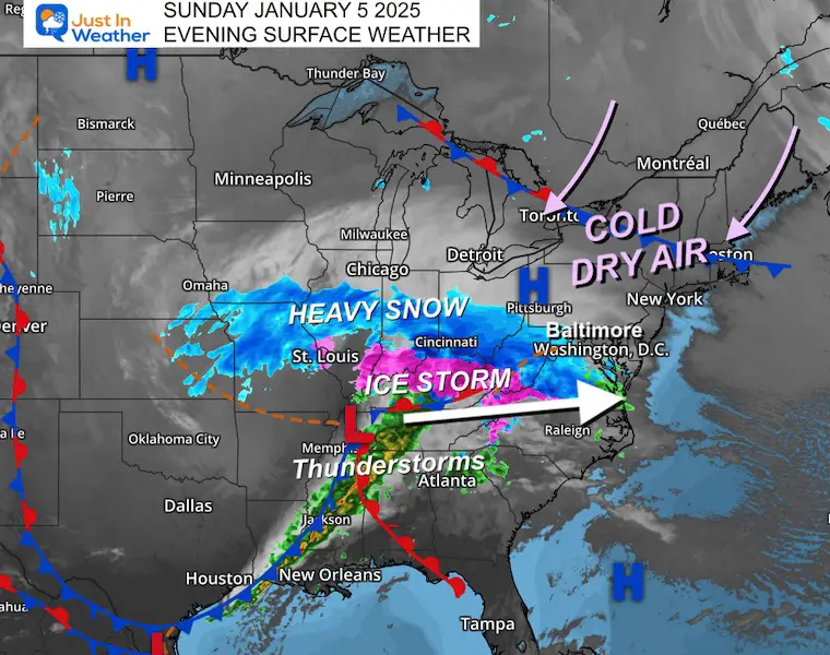
Surface Map
The important feature I want to point out is the arctic air in New England. This is trying to creep south, and it will fill in behind the storm. In the meantime, this is doing two things:
- Keeping the Low Pressure on a Track almost due east.
- Providing very dry air that will erode away some of the northern edge of the snow. This is what will limit totals near and north of the Pennsylvania line.
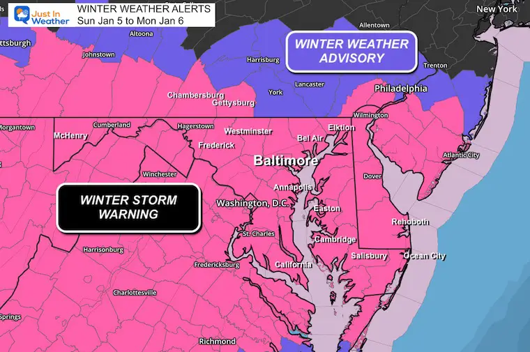
Winter Storm Warning
I can’t remember the last time the Entire State of Maryland was in a Warning. The Advisory to the north is for less snow in very dry air.
See the new timeline below.
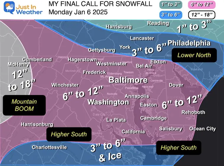
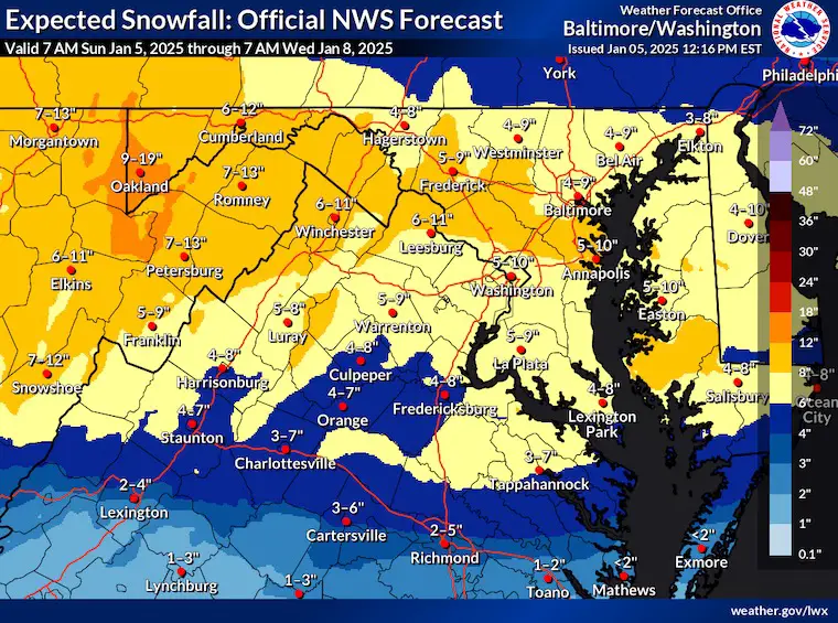
My Final Call For Snowfall
My Changes:
- Expanded the 6 to 12-inch band to include southern Maryland.
- Washington, Annapolis, Salisbury, and Ocean City could be on the upper end of this.
- Hagerstown, Frederick, Westminster, and Bel Air may be on the lower end of the range.
- Southern PA: I lowered just a notch to 3” to 6”, with less in the Lehigh Valley.
- Mountains: They will go BOOM with over 1 foot of snow!
Headlines:
Snow will move in on the radar between Midnight and 4 AM (Mid-Atlantic). There may be an hour or two of Virga (sublimation) where the snow does not reach the ground.
Initial Snow Thump:
The dynamics support heavy snow as soon as it breaks through the dry air. In the morning, it could fall at a rate of 1 inch per hour.
Mid-Day Lull?
There may be a brief transition from snow to showers or a pause in precipitation for a few hours. This is part of the transition.
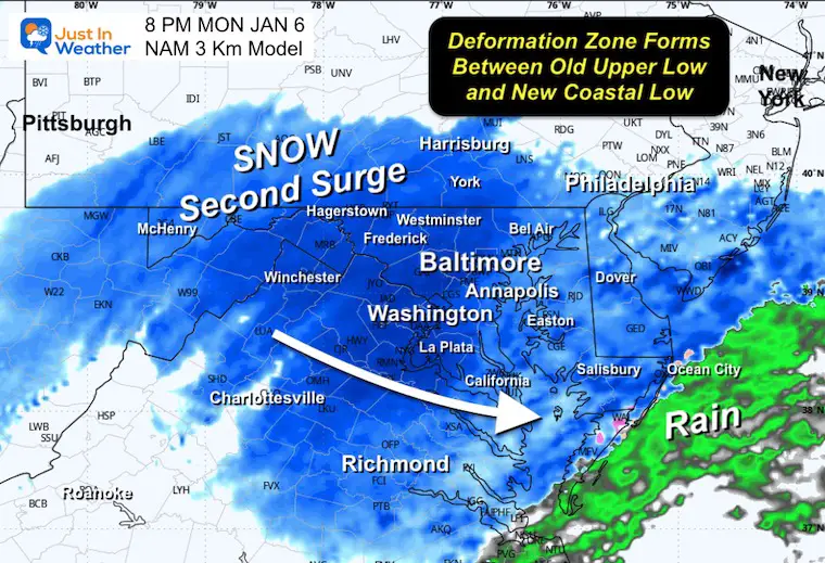
Second Snow Surge Late Day And Evening
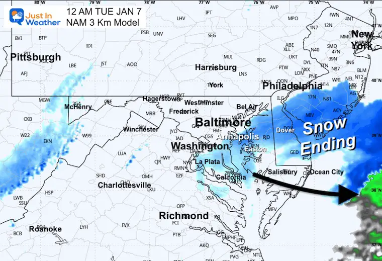
As the storm reforms on the coast, it will send moisture back aloft to the old storm circulation, developing a second batch of accumulating snow. For most, it will end by midnight.
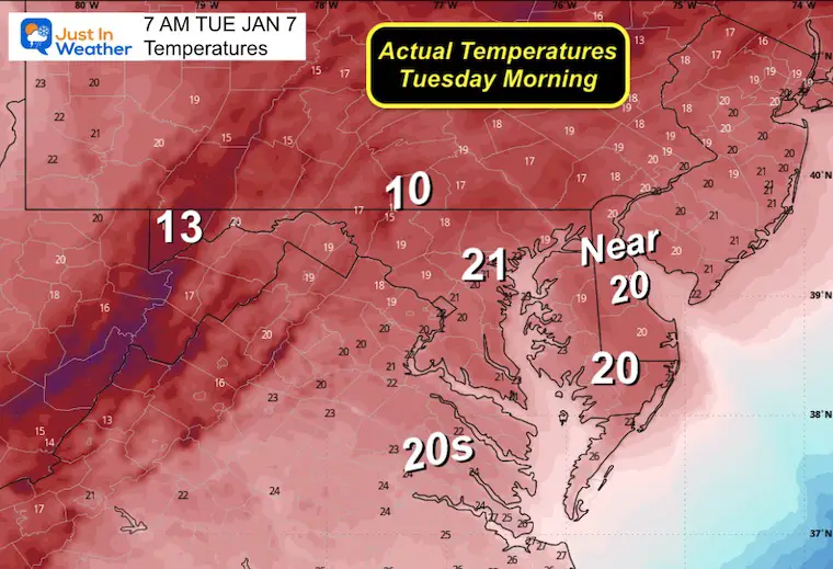
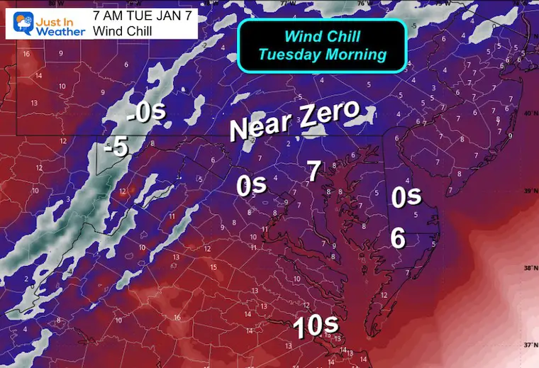
Tuesday Morning Deep Freeze
Very cold temps and bitter wind chills will be enhanced by fresh snowpack.
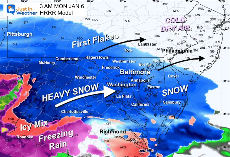
New Radar Simulation
HRRR Model Midnight to Noon
Note that snow may appear on radar for an hour or two before it reaches the ground. This is called Virga: Snow can sublimate in very dry air.
3 AM Monday Snapshot
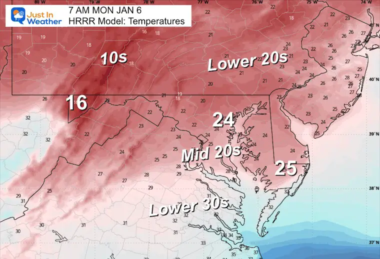
7 AM Monday Snapshot
By this time, all of our region should be in steady snow. Heavy snow may fall at the rate of 1 inch per hour.
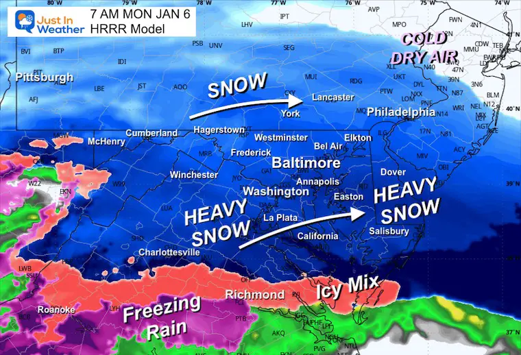
Temperatures
Most of the region should settle in the 20s, which would make for dry and fluffy flakes!
NAM 3KM Simulation 12 AM Monday to 12 AM Tuesday
Timeline snapshots below
Timeline Snapshots
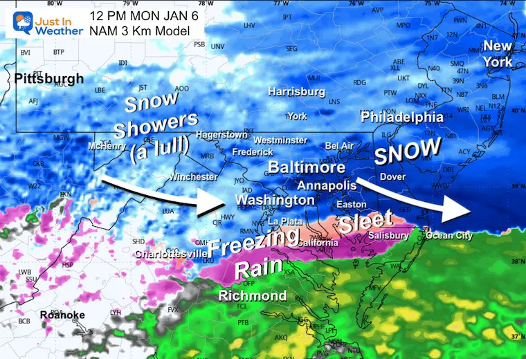
12 PM
This is when a lull may develop across the mountains and shift eastward.
Southern Maryland into the icy mix.
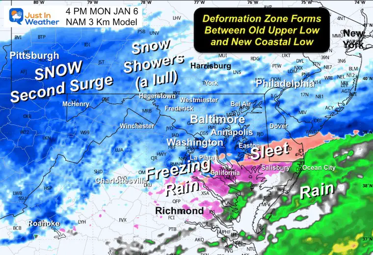
4 PM
8 PM
The Deformation zone is that area in the atmosphere between the Surface Low and the old upper Low inland. The coastal storm will send moisture back to fill in with this second surge of accumulating snow.
Midnight
Tuesday Morning Temperatures
Deep Freeze!
Tuesday Morning Wind Chill
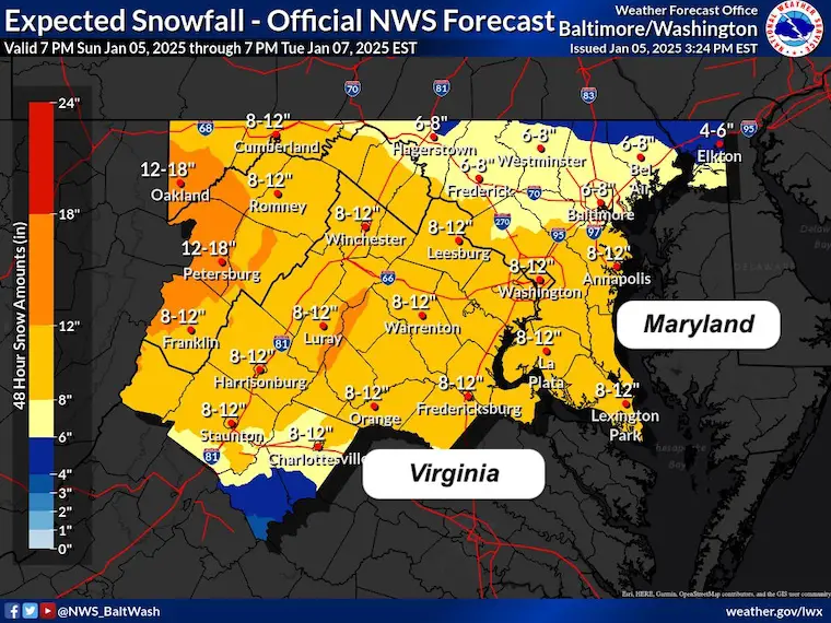
National Weather Service Regional Snow Forecast Maps
Baltimore Washington
They have put out two maps that have some variations but both within my same range.
Mid-Atlantic
This has lower numbers along the Pennsylvania line. But central areas are still in the heavy snow range between 5 to 10 inches. Much more in the mountains to the west.
Just the Forecast Area
This has higher snow along the Pennsylvania Line and most of Central Maryland in the 6″ to 12 inch zone.
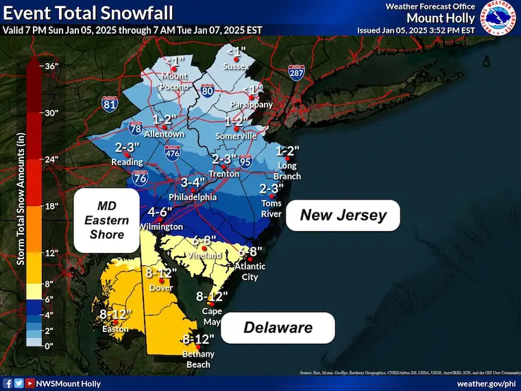
Mount Holly NJ/Philadelphia
Over 6 inches of snow through Delaware and Maryland’s Eastern Shore.
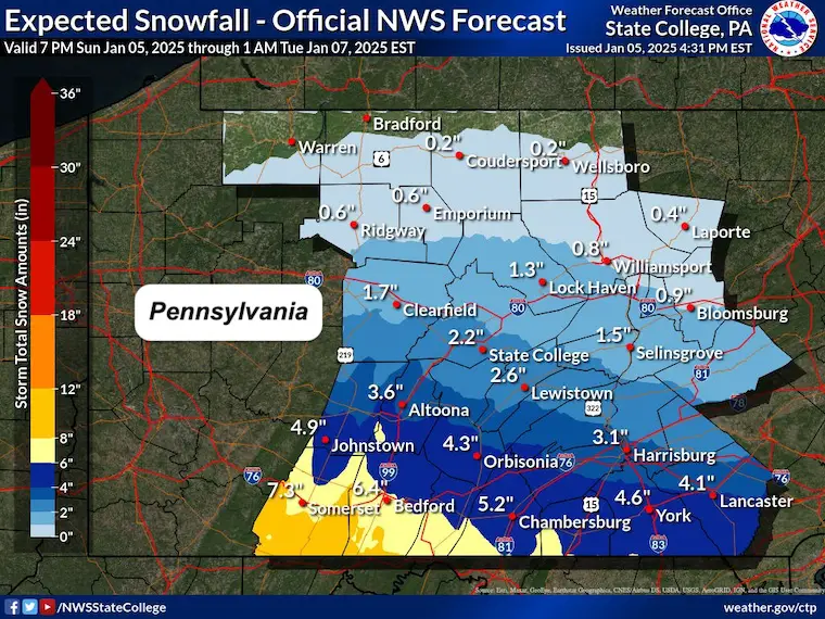
State College PA
A dramatic range of heavy snow on the Maryland line to the south, much less to the north of I-76.
Faith in the Flakes
Subscribe for eMail Alerts
ALSO SEE
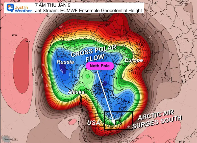
Arctic Outbreak For January
If you missed it, here is my detailed report from December 30 about why this IS A BIG DEAL!
MY WINTER OUTLOOK
My Winter Outlook Report

FITF Gear on Sale

In Case You Missed This
The Faith In The Flakes Dec 5 Origin Story

Previous Snow

Please share your thoughts and best weather pics/videos, or just keep in touch via social media.
SCHEDULE A WEATHER BASED STEM ASSEMBLY
Severe Weather: Storm Smart October and next spring Winter Weather FITF (Faith in the Flakes): November To March Click to see more and send a request for your school.

THANK YOU:
Baltimore Magazine Readers Choice Best Of Baltimore
Maryland Trek 11 Day 7 Completed Sat August 10
We raised OVER $104,000 for Just In Power Kids – AND Still Collecting More
The annual event: Hiking and biking 329 miles in 7 days between The Summit of Wisp to Ocean City.
Each day, we honor a kid and their family’s cancer journey.
Fundraising is for Just In Power Kids: Funding Free Holistic Programs. I never have and never will take a penny. It is all for our nonprofit to operate.
Click here or the image to donate:

RESTATING MY MESSAGE ABOUT DYSLEXIA
I am aware there are some spelling and grammar typos and occasional other glitches. I take responsibility for my mistakes and even the computer glitches I may miss. I have made a few public statements over the years, but if you are new here, you may have missed it: I have dyslexia and found out during my second year at Cornell University. It didn’t stop me from getting my meteorology degree and being the first to get the AMS CBM in the Baltimore/Washington region. One of my professors told me that I had made it that far without knowing and to not let it be a crutch going forward. That was Mark Wysocki, and he was absolutely correct! I do miss my mistakes in my own proofreading. The autocorrect spell check on my computer sometimes does an injustice to make it worse. I also can make mistakes in forecasting. No one is perfect at predicting the future. All of the maps and information are accurate. The ‘wordy’ stuff can get sticky. There has been no editor who can check my work while writing and to have it ready to send out in a newsworthy timeline. Barbara Werner is a member of the web team that helps me maintain this site. She has taken it upon herself to edit typos when she is available. That could be AFTER you read this. I accept this and perhaps proves what you read is really from me… It’s part of my charm. #FITF


