My Winter Outlook For 2024 to 2025: Why I Have Faith In The Flakes
November 20, 2024
Let’s be honest: My outlook is not going to make or break your plans. There is nothing hinging on this other than my professional and personal view on the winter season. I am a weather guy who loves winter and I will surely be accused of bias because of it. I sincerely do my best to provide scientific reasons for my call, and I will do that here.
You may have already seen many outlooks emphasizing La Niña, which is not promising for a lot of snow. That may end up being a smaller factor, and I looked at some other elements.
Before we get started, this is the 15th Anniversary of Faith in the Flakes. It is ‘a thing’ that started with my older son in 2009 after missing an early-season storm. It turned out to be the snowiest winter on record in Baltimore, and winter has fond memories for my entire family. You can read more about the start of Faith In The Flakes (FITF) and why December 5th is so special in this report.
I do have FITF for this winter, considering the many doubts. I will explain below. Let’s get started with a little setup of our local snowfall history.
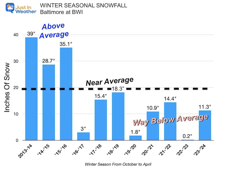
Seasonal Snowfall: 2013 to 2024
After THREE Winters with higher snowfall, the last EIGHT were below average.
We are due for more snow, right? It has to happen at some point.
Long Range History
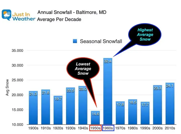
Snowfall Per Decade in Baltimore
Extremes have happened before.
- 1950s Snow Average 14.6” The LOWEST SNOW DECADE
- 1960s Snow Average 32.4” The HIGHEST SNOW DECADE
When I was studying at Cornell, we had an expression: Get four meteorologists in the same room and end up with five different forecasts. The one to use is the last one! An outlook for a season is a low-confidence call but I will do it anyway to keep the streak going. I also know there are many others you may or may not have seen. Most are using La Niña as a basis for the winter weather pattern.
I will add in a few other things I consider, and I’ve decided to purposely go LOWER on my expectations with the hope that I am wrong. Then I will gladly state that if we get clobbered with an old fashioned winter.
With that in mind: I do have Faith in the Flakes for a couple of good storms off the coast, and there will be other storms that may miss us.
Recent Big Swings Of EXTREMES
Using Baltimore’s BWI as a Reference
Rainfall
- RAINY: September 22 to October 2 = 11 Days In A Row With Rain
- DROUGHT: October 3 to November 9 = 38 Days Without Measurable Rain
Temperatures
- Hotter Summer Than Average
- August and September were near Average
- October was actually COOLER THAN AVERAGE
There is potential for the pattern to lock in for a while, which means we could end up with BOTH warm, dry stretches AND routine storms.
Global Patterns
I’ve written about two that may play a role in the jet stream and storm track from the Pacific.
The La Niña Watch in the Equatorial Pacific, and The Pacific Decadal Oscillation (PDO) in the North Pacific.
Here is the quick summary and link to those reports if you want to see more:
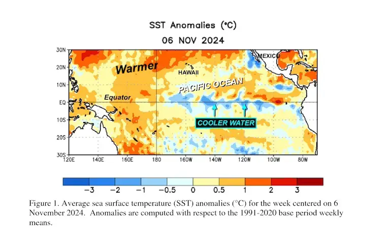
La Niña Watch
NOAA has been dropping the forecast odds each of the last three months. There is now a 57% chance for a La Niña, but as stated here:
“A weak La Niña would be less likely to result in conventional winter impacts, though predictable signals could still influence the forecast guidance. “
In short, this La Niña may be small and not bang the typical expected storm track.
Most La Niña’s result in less snow for our region. But that might be a moot point.
Click this or the image for the report.
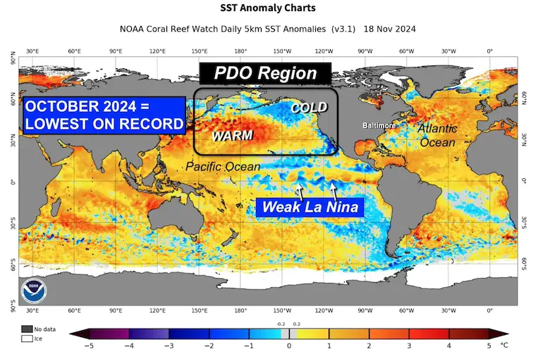
PDO
This October had the LOWEST VALUE ON RECORD. In this report, I compared the other very low Fall values of PDO, and the following winter snowfalls in Baltimore were near average.
When I did include the La Niña, then the snowfall average was slightly above average.
Full Report: Record Low PDO Observed in October: How This May Influence Snow This Winter
Atmospheric Memory
I look for patterns because nature does like to do that. I’ve used this term or a few patterns. In winter, you may recall:
- Snow or ice can begin on the same day of the week. If this happens persistently on a weekend, it can be a waste for teachers and kids.
- Snow or ice can start at the same time of day. Some years, this can be right around the decision time for buses, in the middle of the day, or at night.
- Storms themselves can set up familiar tracks, so we can get snow to rain often, frequent near misses, or the occasional routine hits. That was what we had in the winters of 2010 and 2014.
I have seen hints in storm tracks or source regions with the previous tropical season. I’ll show that below.
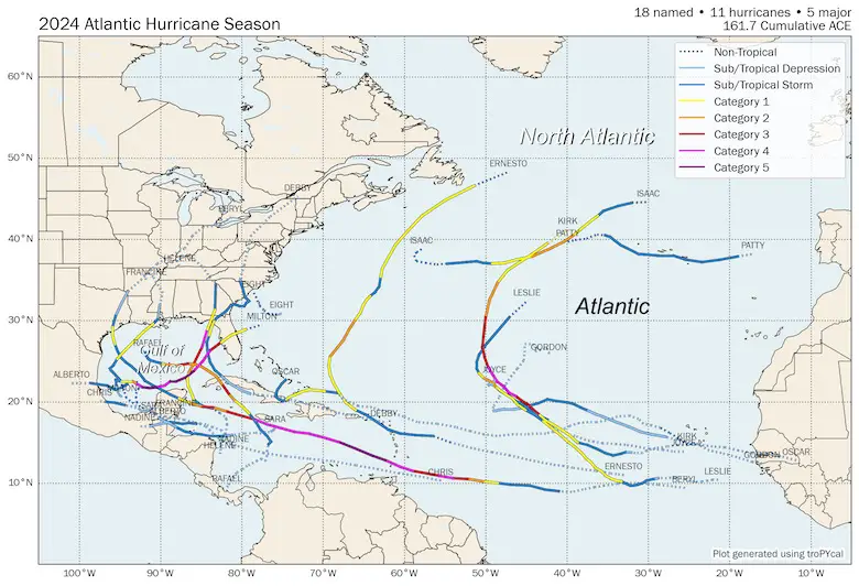
Tropical Storms And Hurricanes of 2024
The season began early and then became quiet for about one month. The real flare-up was after mid-September.
I do believe some of the tracks into the North Atlantic can help with the ocean heat distribution, along with the favored jet stream patterns that can help create the blocking patterns we need to provide cold air to the Eastern US.
Eastern US
Locally, we had to deal with Debby in early August. That tracked up the mountains to the west of the cities.
Two other historic major hurricanes hit Florida this year: Helene, which churned up the Southern Appalachian Mountains to lead to destructive and deadly flooding in North Carolina, and Milton, which hit farther down the coast south of Tampa.
I am more interested in the crossover of tracks in the Eastern Gulf of Mexico. We can add Rafael to this as well.
My ‘theory’ is that there is atmospheric memory in this region to be primed for more storms to develop into the winter season. That is what I labeled the Hot Spot: Storm Source Region.
If this does repeat during winter, then we can look for two tracks I’ve highlighted below: some missing us off the Southeast US coast and a couple with the chance to roll up the coast in classic Nor’easter fashion. This is where the big snows can come from… if there is cold air in place.
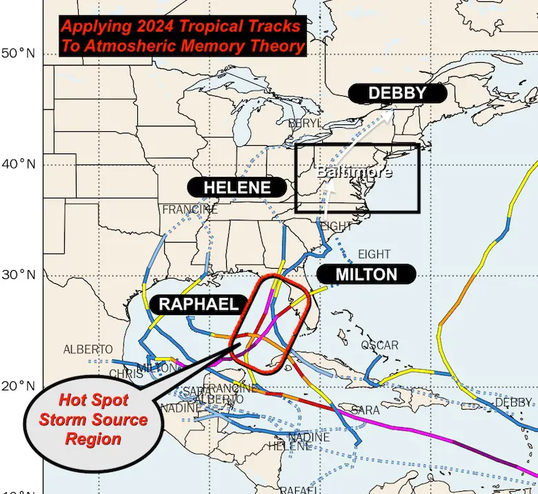
Fall Pattern:
In my notes, I marked October 15 to 18 for a coastal Low AND October 24-25.
These missed us but did play on a large, deep trough in the atmosphere.
You can search for those dates and reports on my site for fun.
Recent Jet Stream
I am completing and posting this report on November 20. This is just prior to the first Lake Effect Snow Event of the season, and possibly a break out of snow showers in metro areas.
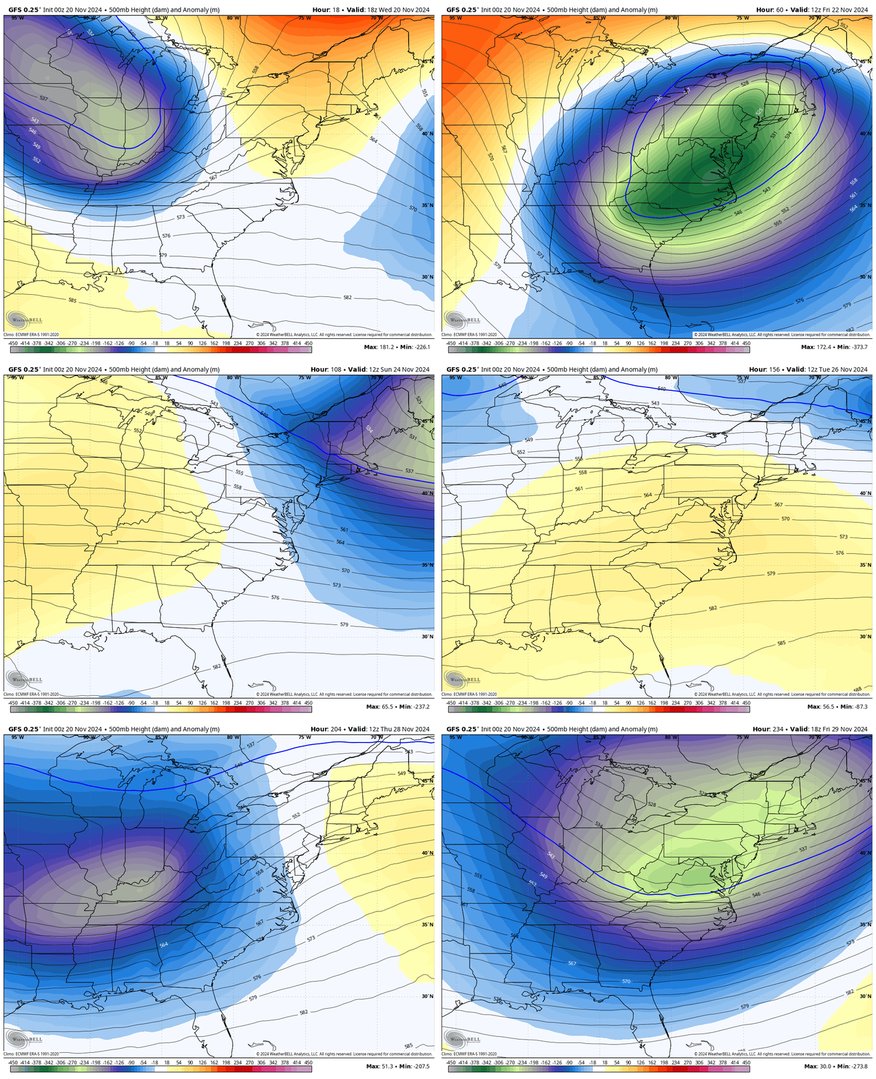
I want to show the 10-day jet stream animation to highlight what I think will be common this winter.
Notice the BLUE/GREEN Deep Trough of cold air swing in and stall briefly across the Eastern US through the weekend. Then a surge of mild air, followed by the next deep trough around or just after Thanksgiving.
Take Away: I see extremes with strong cold storms AND warm-ups in between.
However, much like the 11 days of rain followed by 38 dry days, we can end up locked in one or the other extreme for a while this season. That can lead to some periods with extensive cold and storms, but also long mild stretches.
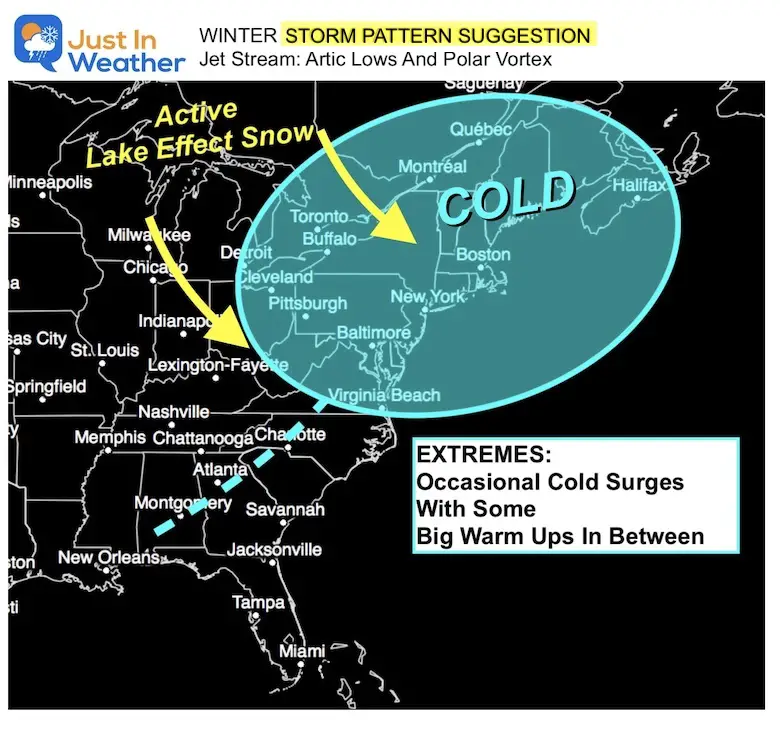
My Winter Storm Pattern SUGGESTIONS
These are NOT THE ENTIRE WINTER, just for the stormy periods.
JET STREAM: Arctic Lows and Polar Vortex
I see a favored spot for Cold Air Masses and Upper-Level Lows in the Jet Stream. This can also bring a visit from the Polar Vortex to supply cold air.
This would favor Lake Effect snow on par with historic averages.
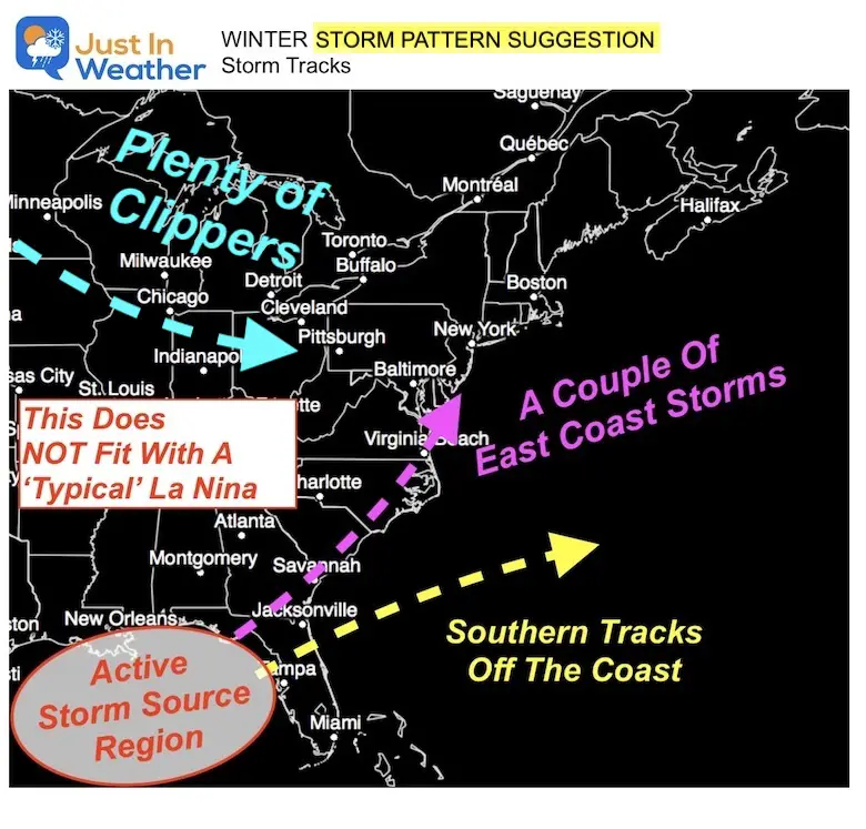
STORM TRACKS
This is when we have a chance for snow: This is NOT a typical La Niña expectation.
- We may get a few Alberta Clippers and warmer tracks inland.
- The eastern Gulf of Mexico is a source region for multiple storms to develop. This is the same region as the high traffic with tropical cyclone tracks.
- Many storms may ride a fast jet stream out to the Atlantic, missing our region to the south.
- A couple of storms may ride a deep trough with cold air in place to produce classic Nor’easters. These are our best chances for higher snow events and a bust for the lower totals.
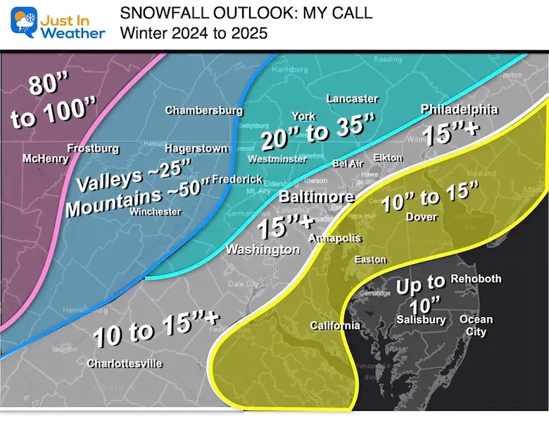
My Call For Snowfall
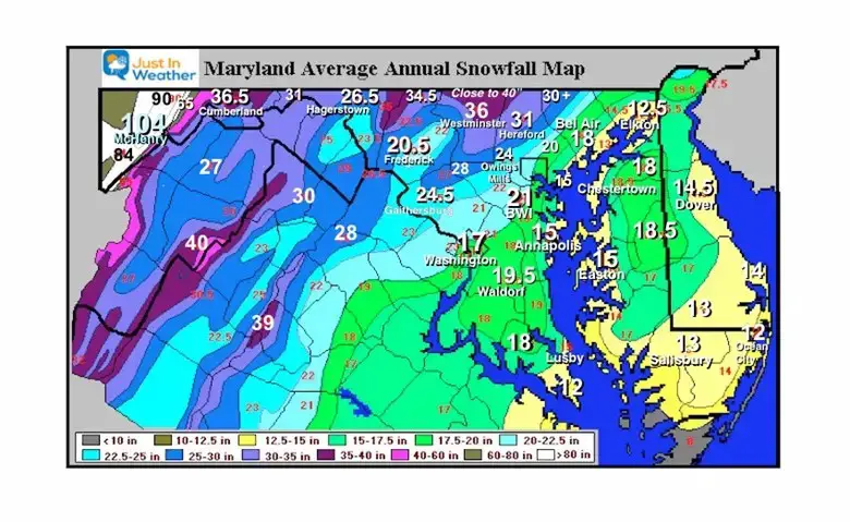
Compare this map to the long-term average map below, and you will see I went slightly below average for most areas.
The mountains may benefit from the Lake Effect events.
La Niña years often bring us lower snow, AND we have had bad luck in the last decade… so that lower trend is a factor.
I do want more snow, and in all honesty, if this plays out, we could BUST ON THE HIGH SIDE if we get two or more Nor’easters.
Long-Term Average Snowfall
Note: Baltimore now has a 30-year average lower at 19.3″.
Let’s see if we can change that?
Faith in the Flakes, my friends. I cheer on snow for the little kid in me and kids everywhere, and I hope I get many days snowboarding on the slopes. So please understand my personal joy, while I will always respect the negative impact on traveling and business.
FITF
My ENTERTAINMENT ONLY Outlook
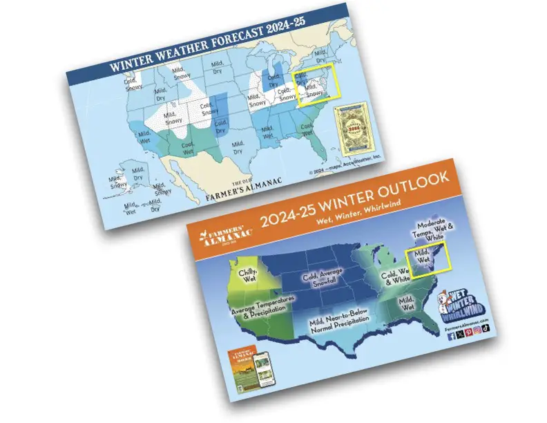
Also See: Comparing Two Farmers Almanacs
Subscribe for eMail Alerts
Weather posts straight to your inbox
Sign up and be the first to know!
Faith in the Flakes Gear
Please share your thoughts and best weather pics/videos, or just keep in touch via social media.
-
Facebook: Justin Berk, Meteorologist
-
Twitter
-
Instagram
SCHEDULE A WEATHER BASED STEM ASSEMBLY
Severe Weather: Storm Smart October and next spring
Winter Weather FITF (Faith in the Flakes): November To March
Click to see more and send a request for your school.
THANK YOU:
Baltimore Magazine Readers Choice Best Of Baltimore
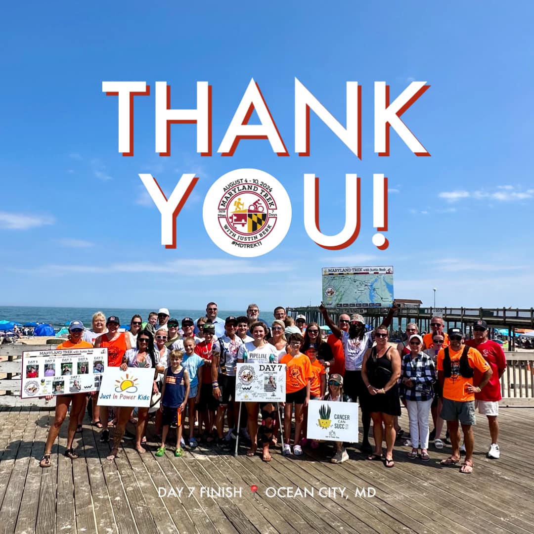
Maryland Trek 11 Day 7 Completed Sat August 10
We raised OVER $104,000 for Just In Power Kids – AND Still Collecting More
The annual event: Hiking and biking 329 miles in 7 days between The Summit of Wisp to Ocean City.
Each day, we honor a kid and their family’s cancer journey.
Fundraising is for Just In Power Kids: Funding Free Holistic Programs. I never have and never will take a penny. It is all for our nonprofit to operate.
Click here or the image to donate:
RESTATING MY MESSAGE ABOUT DYSLEXIA
I am aware there are some spelling and grammar typos and occasional other glitches. I take responsibility for my mistakes and even the computer glitches I may miss. I have made a few public statements over the years, but if you are new here, you may have missed it: I have dyslexia and found out during my second year at Cornell University. It didn’t stop me from getting my meteorology degree and being the first to get the AMS CBM in the Baltimore/Washington region.
One of my professors told me that I had made it that far without knowing and to not let it be a crutch going forward. That was Mark Wysocki, and he was absolutely correct! I do miss my mistakes in my own proofreading. The autocorrect spell check on my computer sometimes does an injustice to make it worse. I also can make mistakes in forecasting. No one is perfect at predicting the future. All of the maps and information are accurate. The ‘wordy’ stuff can get sticky.
There has been no editor who can check my work while writing and to have it ready to send out in a newsworthy timeline. Barbara Werner is a member of the web team that helps me maintain this site. She has taken it upon herself to edit typos when she is available. That could be AFTER you read this. I accept this and perhaps proves what you read is really from me… It’s part of my charm. #FITF


