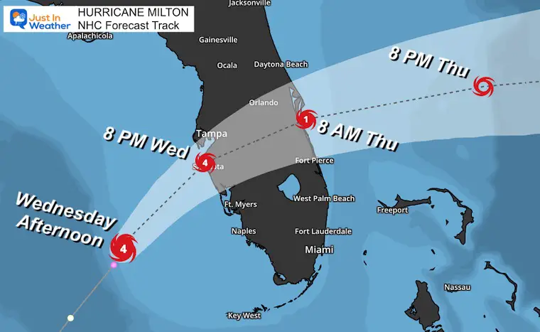
Wednesday Afternoon October 9, 2024
The latest update shows Hurricane Milton with winds of 130 mph, located about 150 miles southwest of Tampa. This is a weaker Category 3 storm and will continue to decrease in intensity, with the strongest winds spreading over a wider area as it moves closer to land. It is moving at 16 mph and is expected to make landfall between 11 PM and 2 AM. There are some important things I hope you share.
The term ‘Downgraded’ Intensity is misleading……I can’t say this enough:
Water and waves will carry the memory of when it was a Category 5 onshore. So whether is is Cat 3 or 4 is negligible at this point. It will expand to cover a larger area.
The wind field has already EXPANDED to 250 miles from the center.
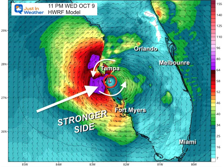
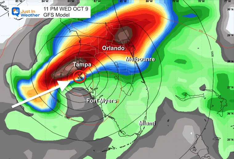
I’ve highlighted the eye landfall south of Tampa. The worst will be south of landfall, but it will still be VERY BAD in and around Tampa. Even if they miss the worst surge, they may be on the edge of the eyewall.
There will be some wobbles in the path, but with the current track, landfall is looking like between Sarasota and Venice.
It will still be a hurricane Thursday morning when it exits the East Coast to The Atlantic.
In this report: Satellite Loops, Landfall Maps, Local Storm Surge Plots, Live Radar, New Model Maps, and Warnings.
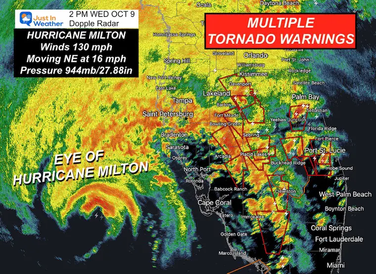
Doppler Radar at 2 PM
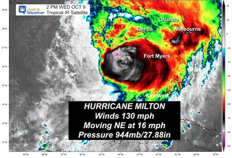
Infrared Satellite at 2 PM EDT
The eye was 150 miles from Tampa.
Moving Northeast at 16 mph…. It will travel faster as it gets closer.
Wind Damage
Hurricane Force Winds: Extend 30 miles from the center
Tropical Storm Force Winds: Extend 250 miles from the center.
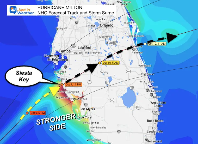
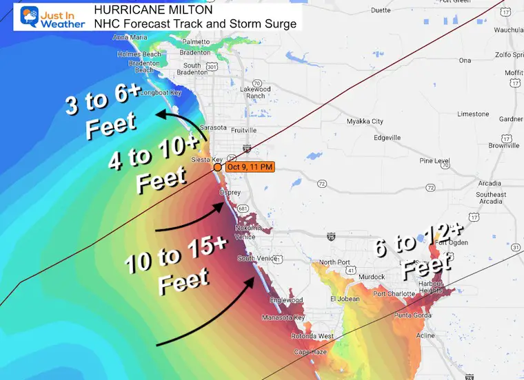
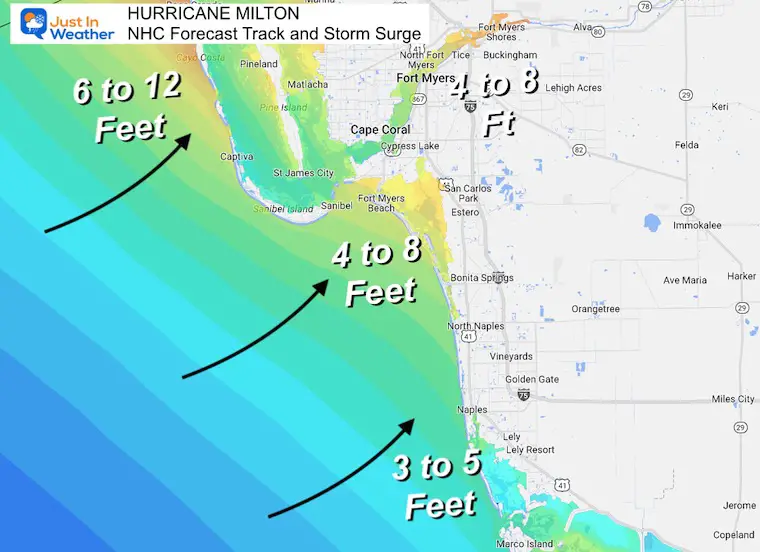
Highest Storm Surge will be at the landfalling eyewall AND on the Right/South Side. New Surge Maps are below.
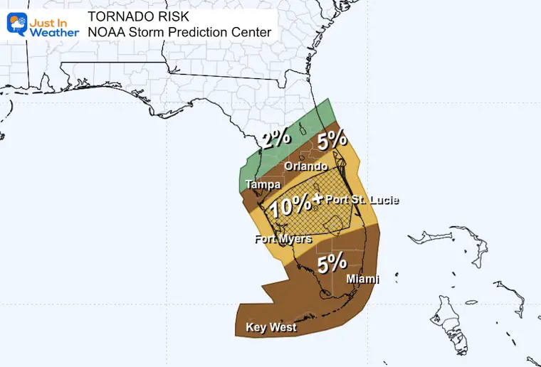
TORNADO RISK
Multiple tornadoes will continue across the state. There was a possible tornado near Miami in Dade County earlier and two in western Broward County.
STORM TRACK: Continues with landfall near Siesta Key and exiting into the Atlantic near Melbourne. It will take 10 to 12 hours to cross the state.
Hurricane-force winds could carry the storm all the way to the Atlantic Coast.
National Hurricane Center SUMMARY OF 2 PM EDT
- LOCATION…26.3N 84.0W
- ABOUT 130 MI…210 KM W OF FT. MYERS FLORIDA
- ABOUT 150 MI…240 KM SW OF TAMPA FLORIDA
- MAXIMUM SUSTAINED WINDS…130 MPH…215 KM/H
- PRESENT MOVEMENT…NNE OR 30 DEGREES AT 16 MPH…26 KM/H
- MINIMUM CENTRAL PRESSURE…944 MB…27.88 INCHES
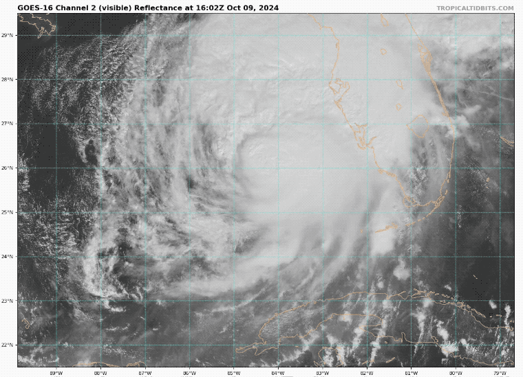
Visible Satellite Loop
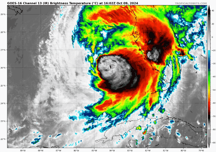
IR Satellite Loop
LIVE RADAR Widget
National Hurricane Center Forecast Track
Hyper Local Looks With Surge Heights Below
There will be some wobbles, but the region between Sarasota to Venice.
Tornado Outlook
Tornadoes are common with landfalling tropical cyclones. This can happen hundreds of miles from the center in the outer bands and has already happened today. This affects much of the state of Florida.
Flooding
Saltwater Flooding is a Storm Surge. Six inches of water can move a person, and 12 inches of water can move an SUV or Truck. The forecast is 10 to 15 feet in the worst areas, which will push well inland.
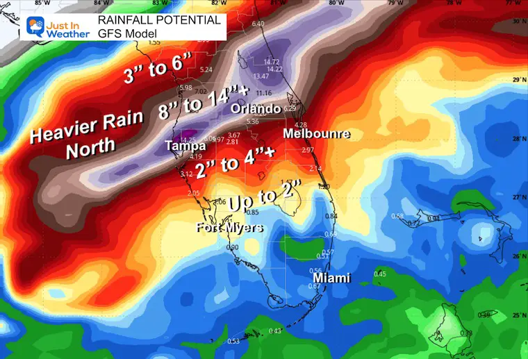
Freshwater flooding is from rainfall. Rainfall rates may be up to 3 inches per hour. The forecast has a total of 9 to 12” or higher in the path and north of the eye track. Some of these areas are already 2 Ft (24”) above rainfall on the year and have been very wet for the last two weeks.
Forecast Adjustment:
The sight change also shifted the landfall location about 50 miles south… which could have a dramatic change in surge expectations along the coast.
See NEW CLOSE-UP Storm Surge Maps below.
Track Still Pointing Just South Of Tampa Bay
These local maps are a guide and NOT A PROMISE. This can still shift 30 to 50 miles in either direction.
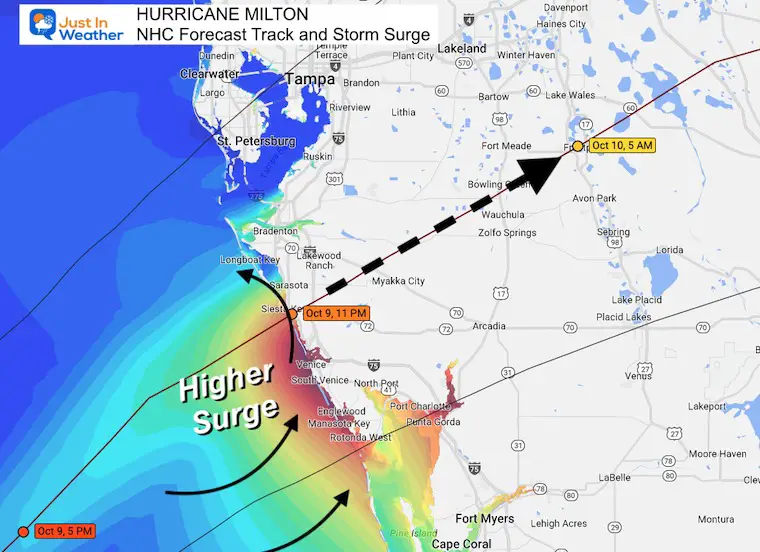
Closer Look At Water Level Expectations
Southwest Florida: Surge More Than 100 Miles Away
Storm Surge Forecast
- Anna Maria Island, FL to Boca Grande, FL…10-15 ft
- Anclote River, FL to Anna Maria Island, FL…8-12 ft
- Tampa Bay…8-12 ft
- Boca Grande, FL to Bonita Beach, FL…8-12 ft
- Charlotte Harbor…8-12 ft
- Bonita Beach, FL to Chokoloskee, FL…5-8 ft
- Aripeka, FL to Anclote River, FL…3-5 ft
- Chokoloskee, FL to Flamingo, FL…3-5 ft
- Sebastian Inlet, FL to Altamaha Sound, GA…3-5 ft
- Altamaha Sound, GA to Edisto Beach, SC…2-4 ft
- Yankeetown, FL to Aripeka, FL…2-4 ft
- Dry Tortugas…2-4 ft
- St. Johns River…2-4 ft
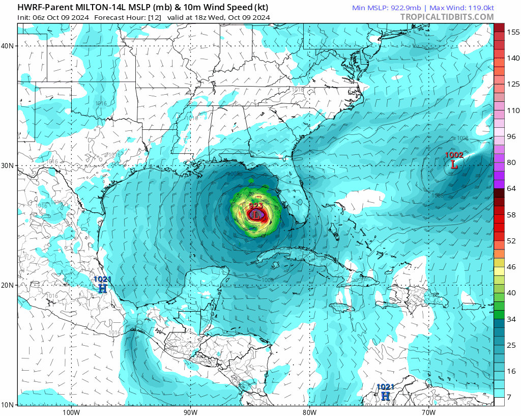
HAFS Model Animation: Wed Afternoon to Fri Morning
This has been doing a good job leading the pack with the track adjustment.
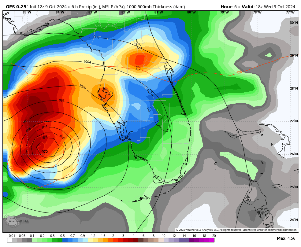
Landfall Forecast
This is leaning toward 10 PM to 11 PM.
GFS Model Landfall Forecast
GFS Model Animation: Wed Morning To Fri Morning
Rainfall Forecast
Freshwater Flooding is likely with 10 to 14 inches+ along and just north of the path.
Models have a tough time with tropical rain bands and often results end up higher.
SUMMARY OF WATCHES AND WARNINGS IN EFFECT:
A Storm Surge Warning is in effect for…
* Florida west coast from Flamingo northward to Yankeetown, including Charlotte Harbor and Tampa Bay
* Sebastian Inlet Florida to Altamaha Sound Georgia, including the St. Johns River
A Hurricane Warning is in effect for…
* Florida west coast from Bonita Beach northward to Suwannee River, including Tampa Bay
* Florida east coast from the St. Lucie/Martin County Line northward to Ponte Vedra Beach
A Storm Surge Watch is in effect for…
* North of Altamaha Sound Georgia to Edisto Beach South Carolina
A Hurricane Watch is in effect for…
* Dry Tortugas
* Lake Okeechobee
* Florida west coast from Chokoloskee to south of Bonita Beach
* Florida east coast north of Ponte Vedra Beach to the mouth of the St. Marys River
* Florida east coast from the St. Lucie/Martin County Line to the Palm Beach/Martin County Line
A Tropical Storm Warning is in effect for…
* Florida Keys, including Dry Tortugas and Florida Bay
* Lake Okeechobee
* Florida west coast from Flamingo to south of Bonita Beach
* Florida west coast from north of Suwanee River to Indian Pass
* Florida east coast south of the St. Lucie/Martin County Line to Flamingo
* North of Ponte Vedra Beach Florida to the Savannah River
* Extreme northwestern Bahamas, including Grand Bahama Island, the Abacos, and Bimini
A Tropical Storm Watch is in effect for…
* North of the Savannah River to South Santee River South Carolina
Recap Of The 2024 Atlantic Tropical Season So Far:
Named Storms
- Alberto June 19 to 20; Peaked As Tropical Storm
- Beryl June 28 11; Peaked As Cat 5 Hurricane
- Chris June 30 to July 1; Peaked As Tropical Storm
- Debby August 3 to 9; Peaked as a Category 1 Hurricane
- Ernesto August 12 to 20; Peaked As Cat 2 Hurricane
- Francine September 9 to 12; Peaked As Cat 2 Hurricane
- Gordon September 11 to 17; Tropical Storm
- Helene September 24 t0 27; Cat 4 Hurricane. Landfall with 140 mph winds
- Joyce September 27 to 30; Tropical Storm
- Kirk September 29 to ; Cat 4 Hurricane : Ocean with 145 mph winds
- Leslie October 2 to ; Cat 1 Hurricane
- Milton October 5 to


