


January 2 Weather Still Cold This Weekend With A Warm Up Next Week
Friday, January 2, 2026 After the New Year's Day Morning Snow Squall, the cold air mass has been firmly in place. One more system passed through overnight with flurries and…
Thursday, September 26, 2024
Morning Report
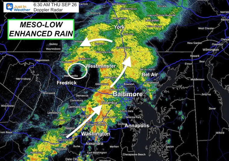
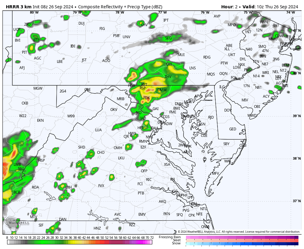
More rain and even strong thunderstorms reached parts of central Maryland this morning. This is NOT from Helene, but another system that will help bring more wet weather our way.
There was a mesoscale Low Pressure that I plotted in Northern Frederick County at 6:30 AM. This is the reason for the pulse of heavy rain. It will track to the Northeast, but more impulses are possible in this same area today, mainly near and west of I-95.
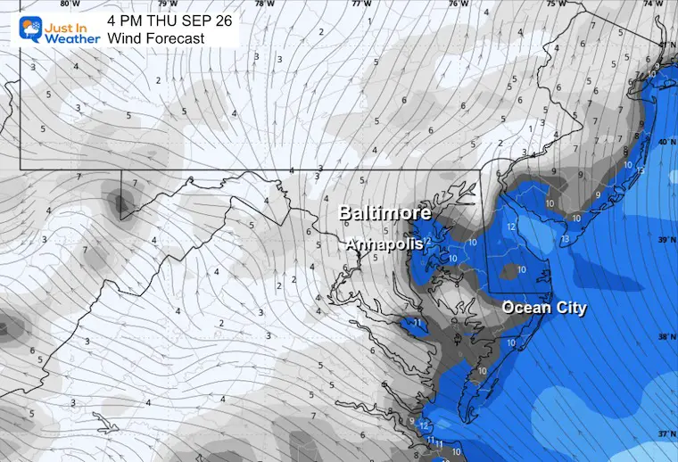
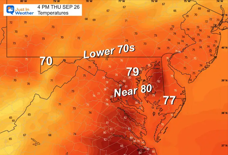
A southeast wind will help bring a muggy feel to the air. This will keep temperatures in a small range from morning to night. There will also be clouds and periods of rain.
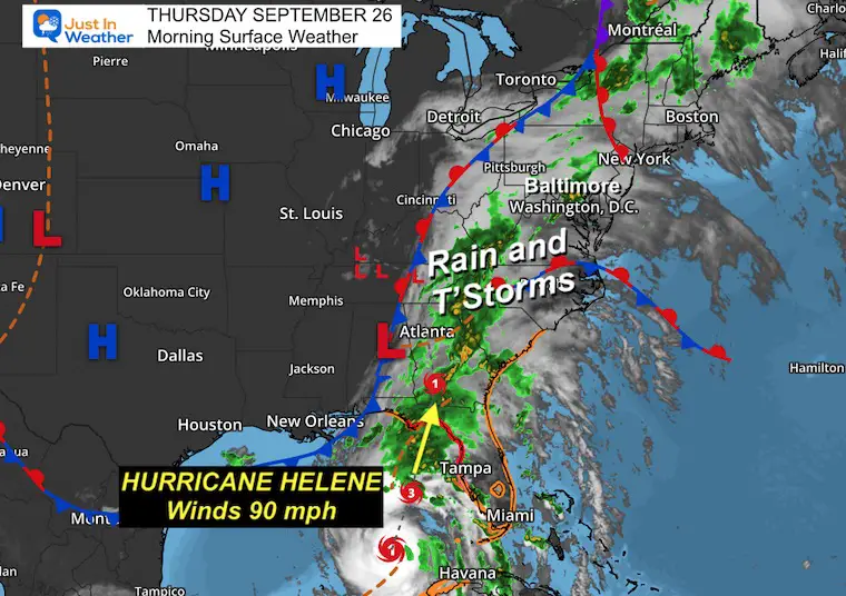
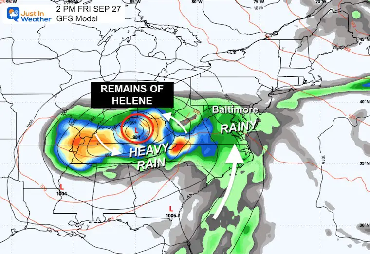
More rain will arrive Friday. This will be from Helene after making landfall in Florida, but we will remain very far away from that storm. It will help influence more showers each day into next week.
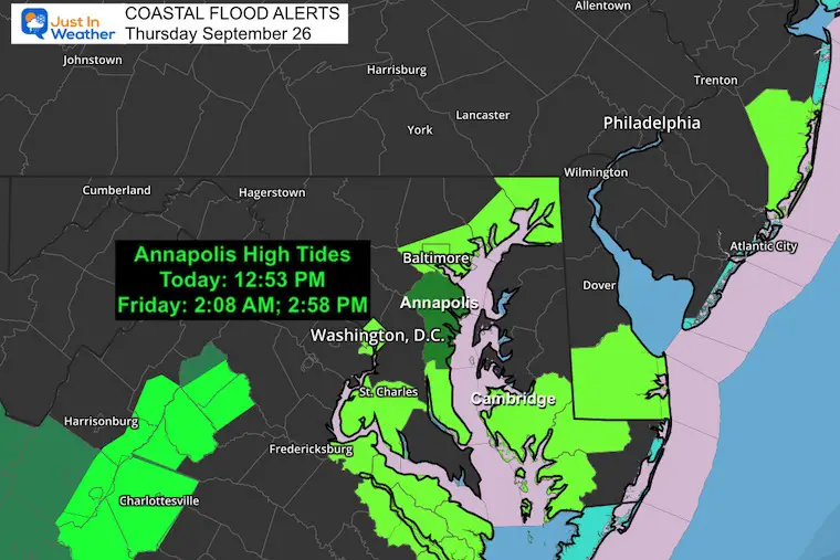
The higher water continues with the Easterly Winds raising water with each high tide. This may continue into the middle of next week.
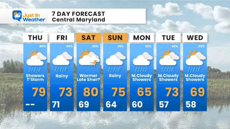
Rainfall and thunderstorms this morning will pulse and continue this afternoon ahead of a nearly stalled cold front, sending impulses of energy our way.
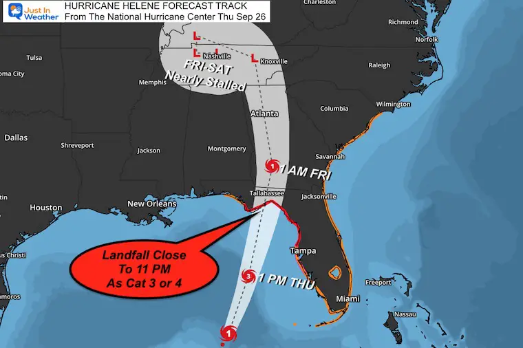
Hurricane Helene will strengthen and make landfall in Florida’s Big Bend tonight. The track shown here will move inland. It will send more rain our way tomorrow, then another cluster on Sunday.
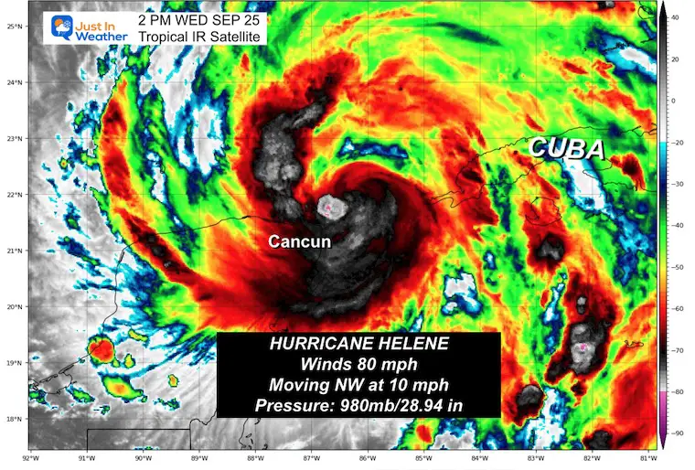
This morning, winds were at 90 mph in the Gulf of Mexico. It is expected to at least reach Category 3 before making landfall tonight. It may not be as strong as the model forecast yesterday, but it is still very dangerous.
This is a LARGE STORM
Hurricane Force Winds Reach 60 miles from the center
Tropical Storm Force Winds reach 345 miles from the center. That is NEARLY 700 miles wide!
New Hurricane Warnings plus a State of Emergency is in place for Florida and Georgia.
Click here or the these images for the full morning report on this storm.
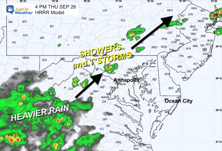
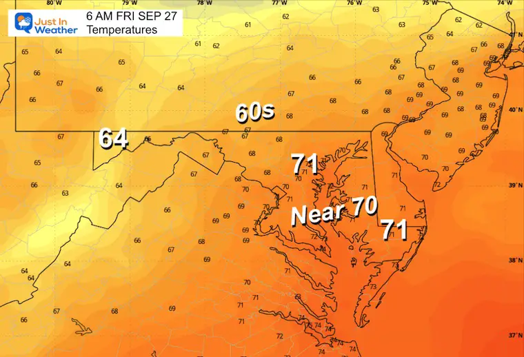
Periods of rain will continue, and likely more than shown here. At times, steady rain will pulse with periods of drizzle and fog.
The flow from the Southeast is why the Bay water remains high. This will also give the air a muggy feel for a few days.
Sunrise at 6:59 AM
Sunset at 6:56 PM
Normal Low in Baltimore: 55ºF
Record 40ºF in 1879
Normal High in Baltimore: 76ºF
Record 95ºF 1970
Rain from Helene is possible. The small variation of temperatures throughout the day is a signal of a lot of humidity in the air.
Here is the wide view look at what is expected to be Major Hurricane Helene hitting Florida tonight.
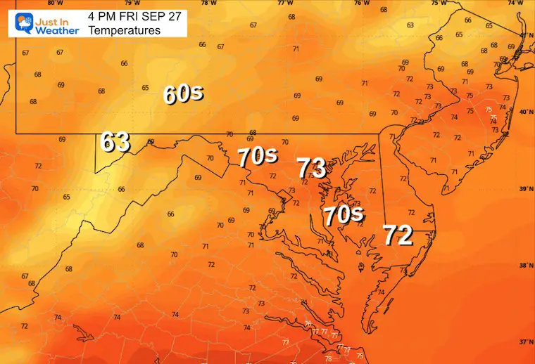
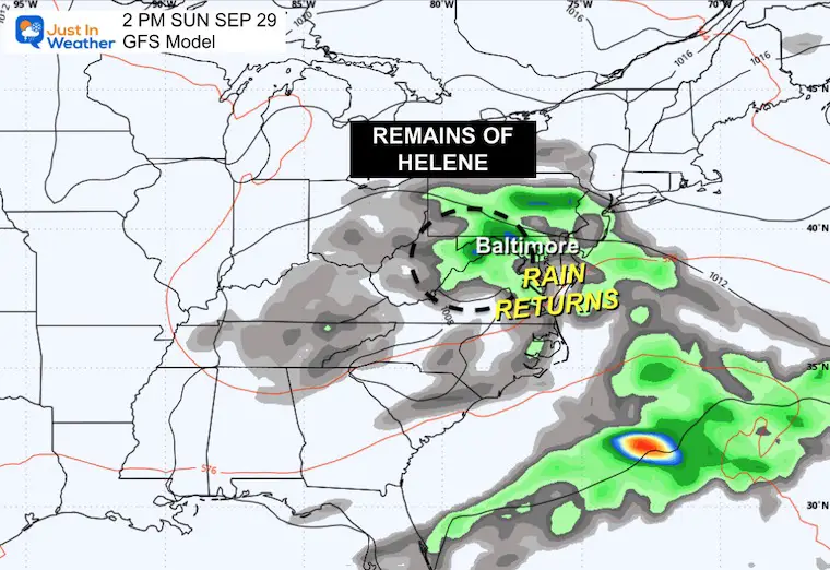
While the main storm misses us, the surge of a plume of rain will arrive into the Mid-Atlantic by Friday, heavier at night. We may get dry air on Saturday, then back to the rain on Sunday.
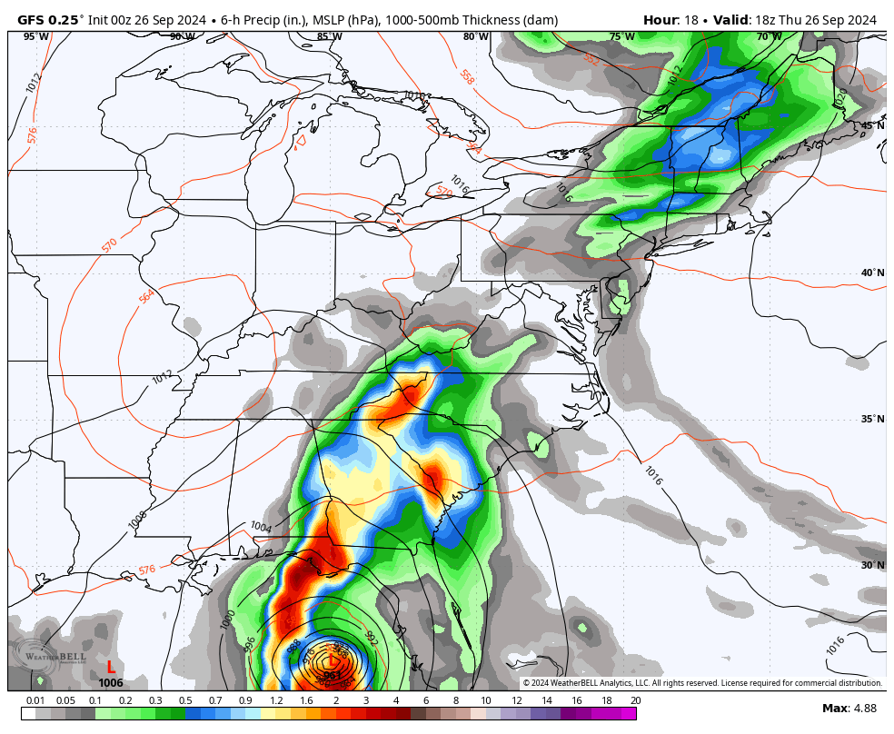
The initial rain band from the east side of the landfalling hurricane will ride a low-level jet up the East Coast.
We get rain in the afternoon and at night.
Warm and humid, but we may get a break from the rain for the day. However we can’t rule out some pop- up thunderstorms in the afternoon and evening.
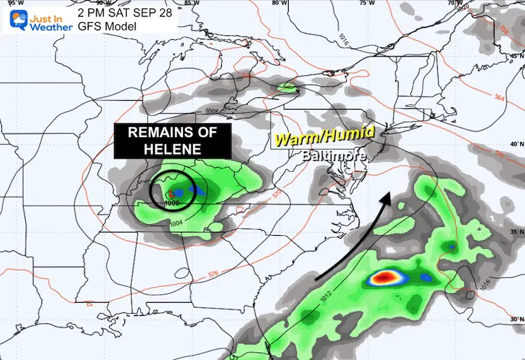
Upper-level energy from Helene moves over the Mid-Atlantic and nearly stalls. This brings more rain this day and into early next week.
Severe Weather: Storm Smart October and next spring
Winter Weather FITF (Faith in the Flakes): November To March
Click to see more and send a request for your school.

The annual event: Hiking and biking 329 miles in 7 days between The Summit of Wisp to Ocean City.
Each day, we honor a kid and their family’s cancer journey.
Fundraising is for Just In Power Kids: Funding Free Holistic Programs. I never have and never will take a penny. It is all for our nonprofit to operate.
Click here or the image to donate:

I am aware there are some spelling and grammar typos and occasional other glitches. I take responsibility for my mistakes and even the computer glitches I may miss. I have made a few public statements over the years, but if you are new here, you may have missed it: I have dyslexia and found out during my second year at Cornell University. It didn’t stop me from getting my meteorology degree and being the first to get the AMS CBM in the Baltimore/Washington region.
One of my professors told me that I had made it that far without knowing and to not let it be a crutch going forward. That was Mark Wysocki, and he was absolutely correct! I do miss my mistakes in my own proofreading. The autocorrect spell check on my computer sometimes does an injustice to make it worse. I also can make mistakes in forecasting. No one is perfect at predicting the future. All of the maps and information are accurate. The ‘wordy’ stuff can get sticky.
There has been no editor who can check my work while writing and to have it ready to send out in a newsworthy timeline. Barbara Werner is a member of the web team that helps me maintain this site. She has taken it upon herself to edit typos when she is available. That could be AFTER you read this. I accept this and perhaps proves what you read is really from me… It’s part of my charm. #FITF