Something Tropical May Form In The Gulf Then US Landfall Later This Week
September 22, 2024
Sunday Morning
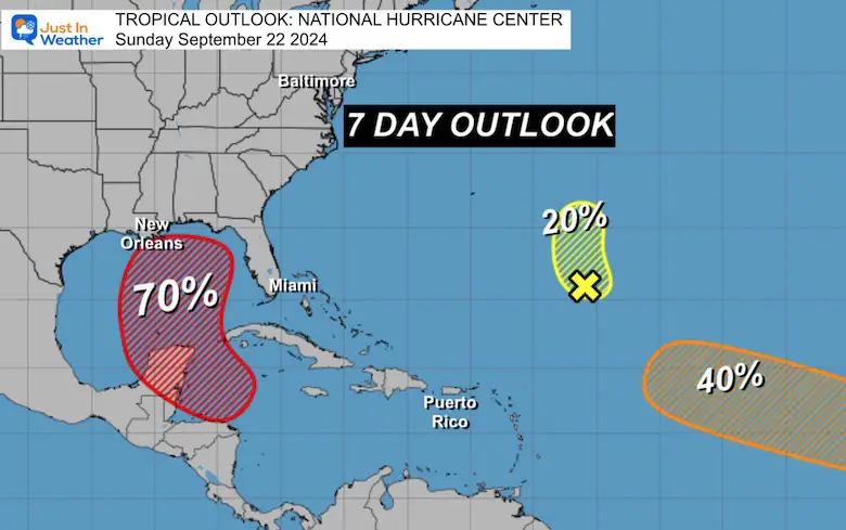
A large area of the Northwestern Caribbean Sea into the Central Gulf of Mexico is being monitored. The National Hurricane Center has identified this region with a 70% chance of tropical formation over the next 7 days! This is a POTENTIAL – NOT A PROMISE.
That is important to note, considering just one week ago, we were watching a storm off the South Carolina coast that was expected to develop into a tropical storm. Despite 50 mph winds and 20 inches of rainfall in coastal North Carolina, it was never named because it did not have a true tropical structure.
This new area is different as it is farther south and over very warm water. It has a better chance to become a true tropical structure with a central warm core.
Any forecast maps at this point are purely speculation or an educated guess. This storm has NOT FORMED YET. So, the precise location and timing of a Low-Pressure center can determine how it will behave and move further down the line. It is a theme I will repeat over the winter with any snowstorm nearly one week or more away. It is nearly impossible to lock in with confidence before a storm even forms. But here we go. I will play along for a glimpse, so let’s take a look.
Also, see the interactive Windy Widget at the bottom of this post after the computer model maps.
The 2024 Atlantic Tropical Season Named Storms So Far:
- Alberto June 19 to 20; Peaked As Tropical Storm
- Beryl June 28 11; Peaked As Cat 5 Hurricane
- Chris June 30 to July 1; Peaked As Tropical Storm
- Debby August 3 to 9; Peaked as a Category 1 Hurricane
- Ernesto August 12 to 20; Peaked As Cat 2 Hurricane
- Francine September 9 to 12; Peaked As Cat 2 Hurricane
- Gordon September 11 to 17; Tropical Storm
Helene is the NEXT NAME on the list.
National Hurricane Center Outlook
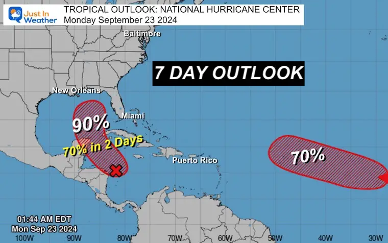
A few regions are being tracked, but the red-shaded area is the one we are concerned with. Reminder that this is the 7-Day outlook. The potential development may be more likely Wednesday or Thursday.
Water temperatures are in the upper 80s, which supports development if the upper-level winds cooperate.
UPDATE MONDAY MORNING
Computer Model Comparisons
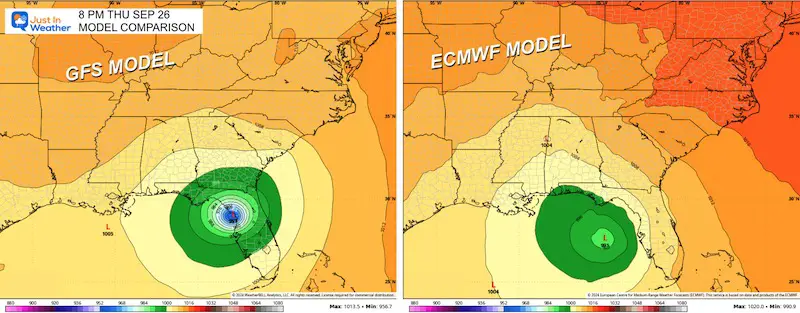
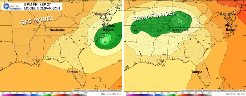
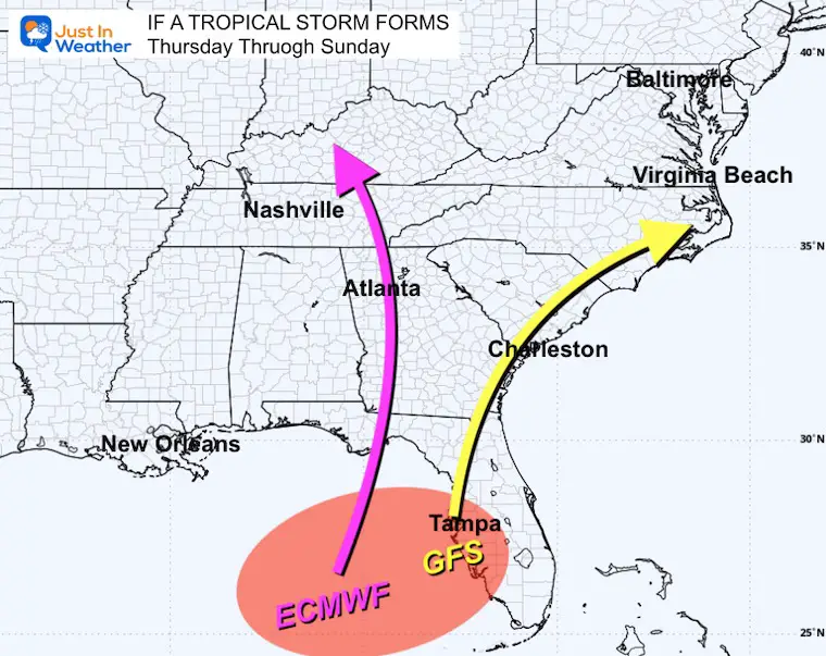
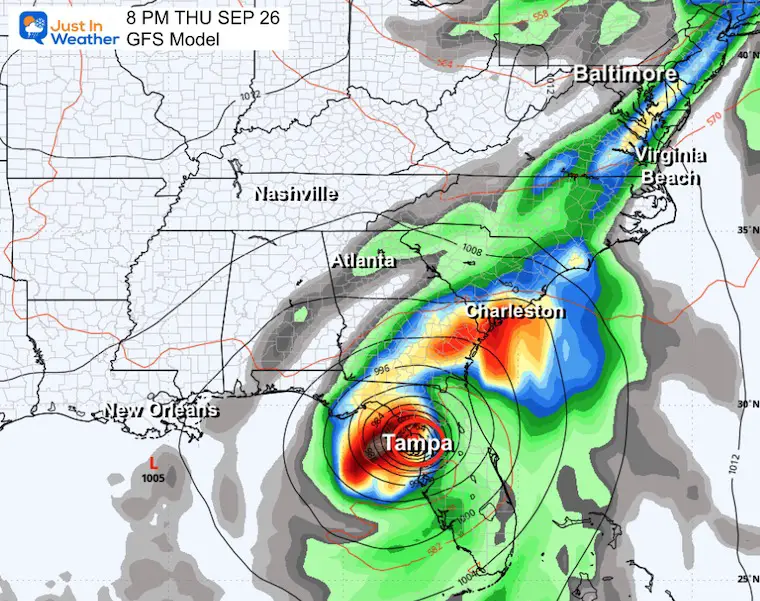
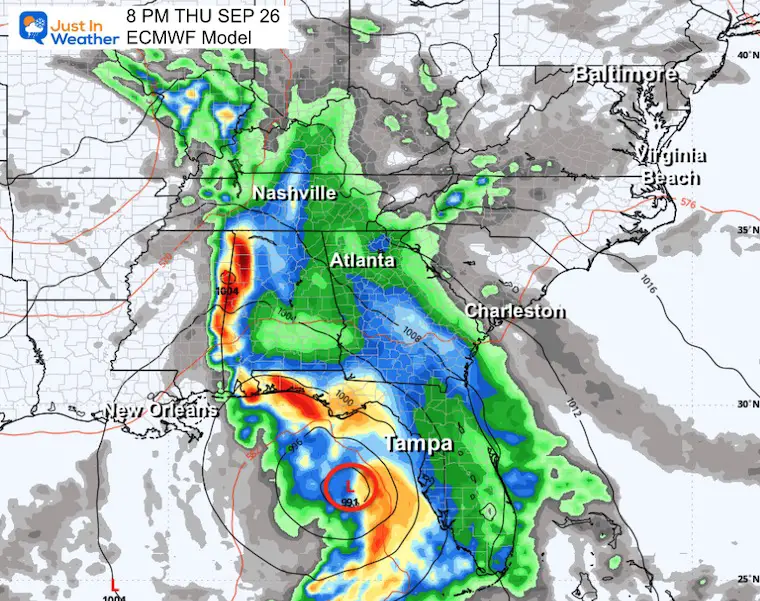
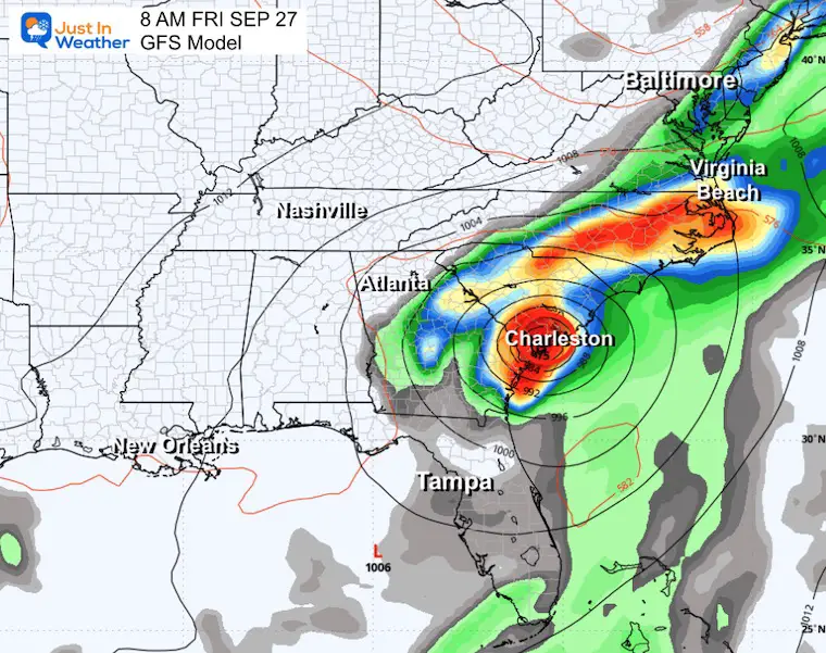
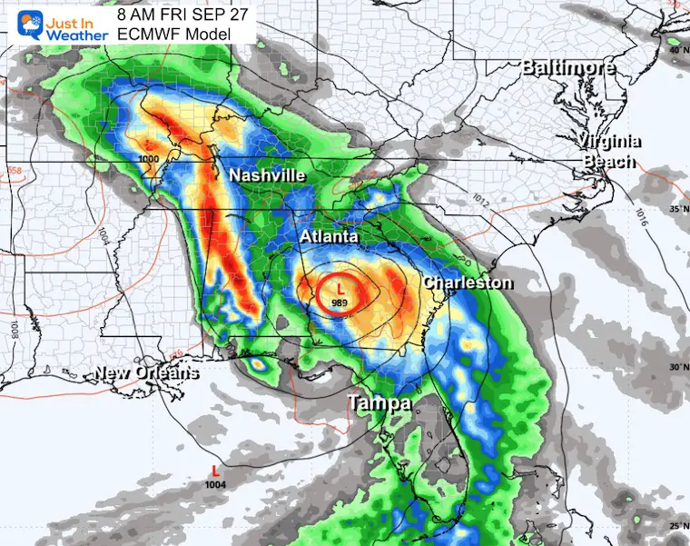
Here is a look at the American GFS and European ECMWF Models. Both show a developing storm in the Eastern Gulf of Mexico by Thursday, but they have very different tracks and impacts.
GFS is STRONGER: It shows landfall north of Tampa, then a track to South Carolina and out to the Atlantic.
ECMWF is WEAKER: This shows a more northerly track and into the Ohio Valley.
Thursday Night
Friday Night
GUESSWORK
This proves it is too early, AND there is no guarantee of who will get impacted.
The latest future tracks of Low Pressure vary widely between the GFS and European ECMWF Models. Again, this is based on where each model sees a Low Pressure forming when that happens, and the influence of the upper-level winds on the development and movement.
For the Mid-Atlantic, the two current setups miss us and only feed moisture into our cold front (a different system). But if anything tracks in the middle, we need to stay on the lookout.
Animations:
Thursday, September 26 to Sunday, September 29
Key Time ‘Snapshot Comparison’ is below.
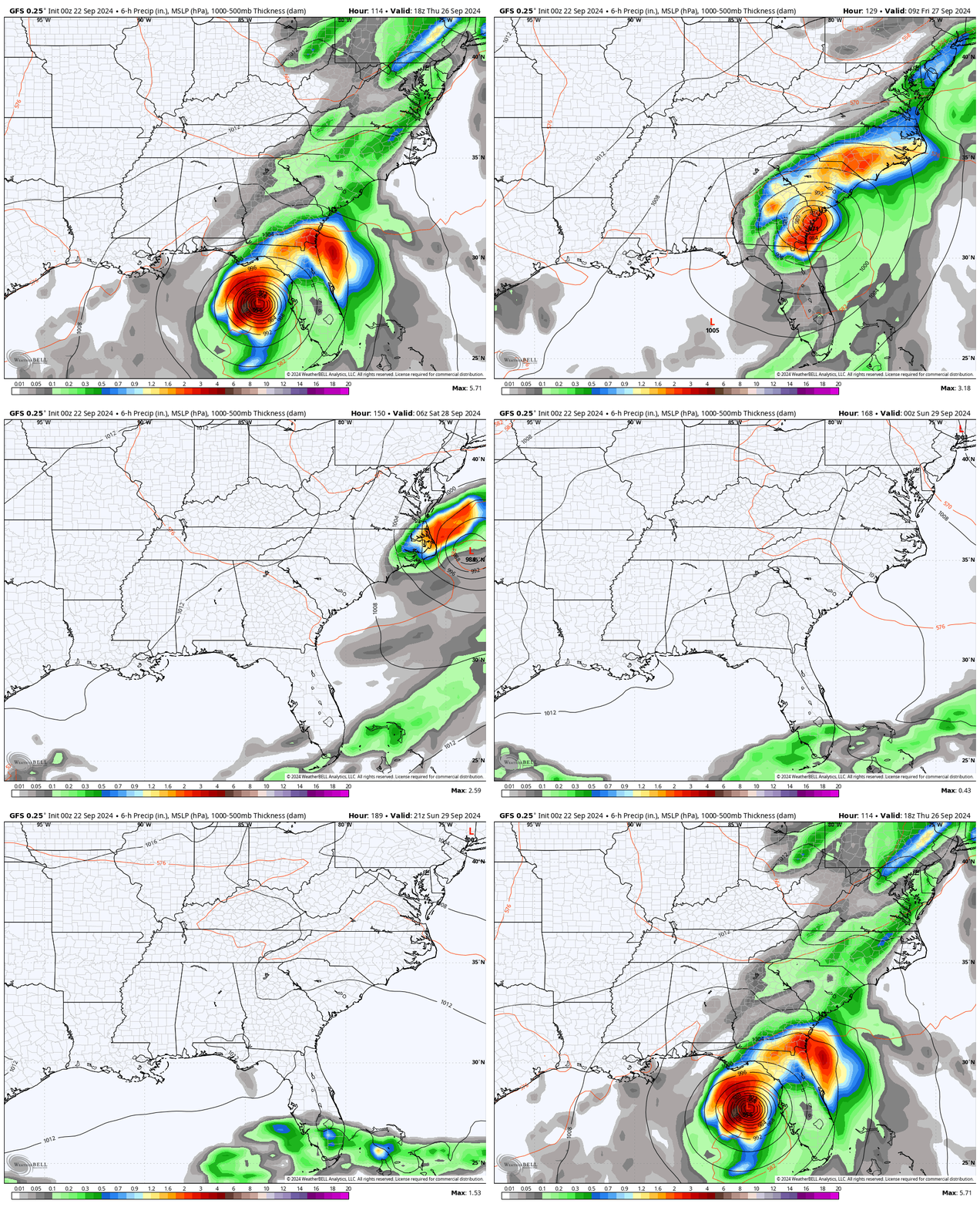
GFS Model
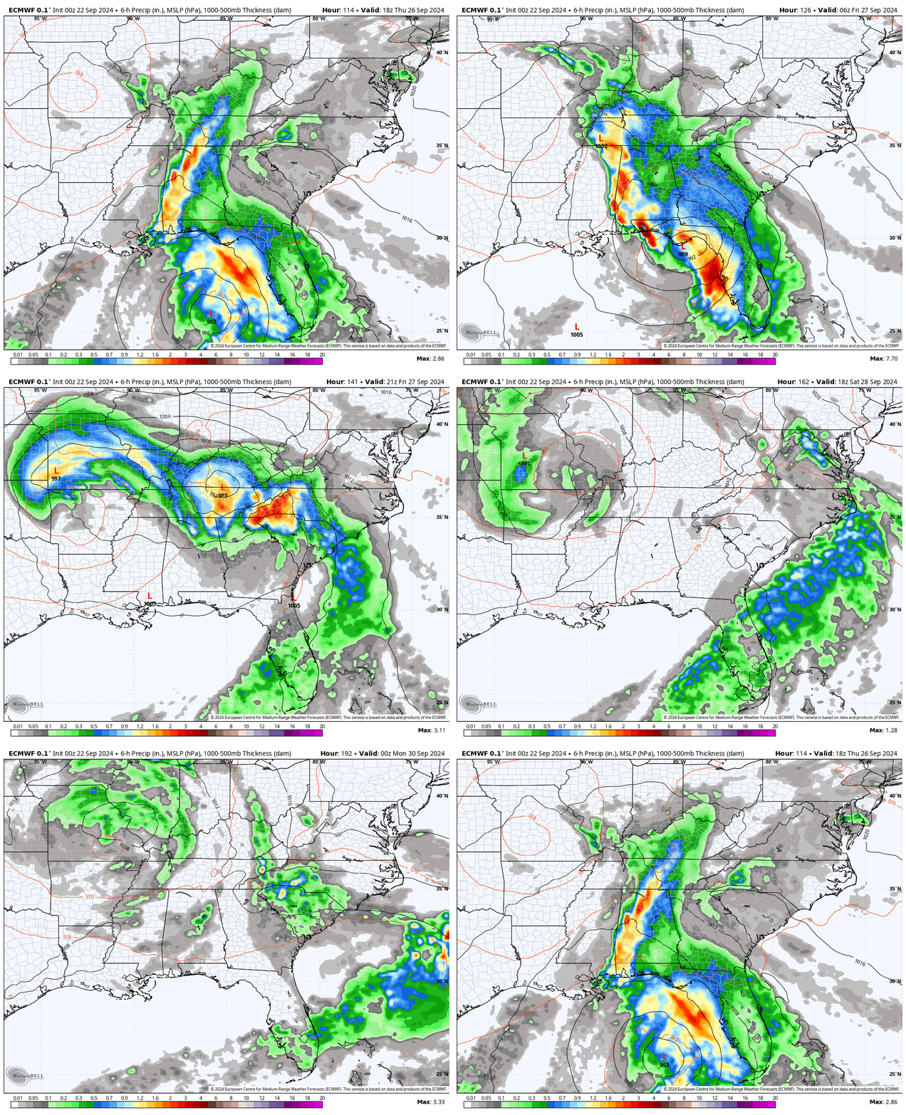
ECMWF Model
Snapshot Comparison
Reminder: These are suggestions and are likely subject to change depending on when the storm takes form.
Thursday Night
GFS Model
This plot shows a landfall North of Tampa, FL.
ECMWF Model
This plot shows the core Low Pressure still over the water and not as strong.
Friday Morning
GFS Model
This plot has the (possible tropical) storm over coastal South Carolina near Charleston.
ECMWF Model
This plot has Low Pressure much farther west in central Georgia.
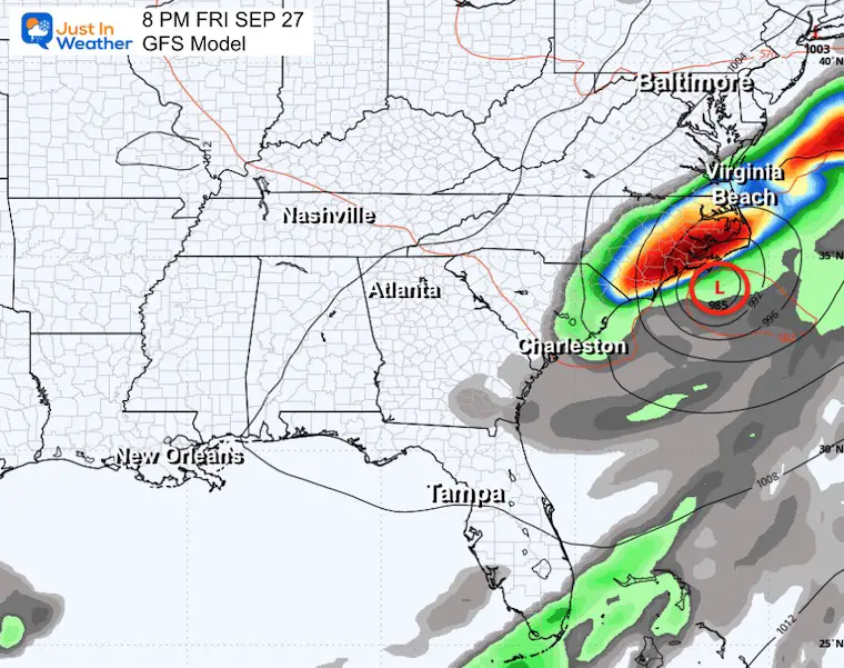
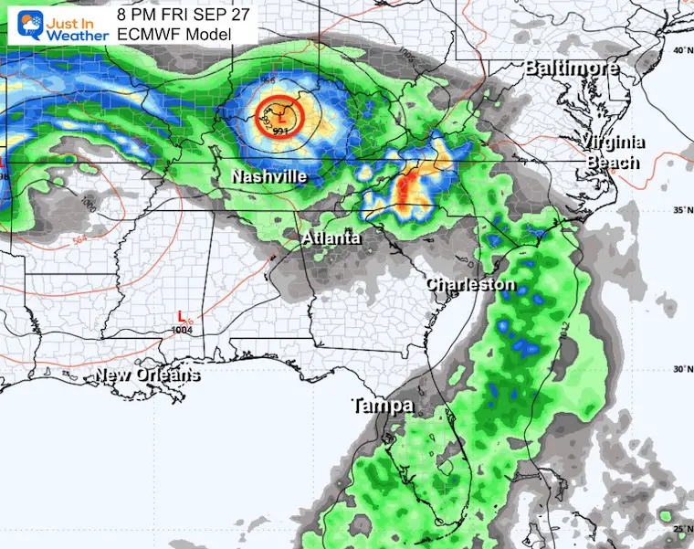
Friday Night
GFS Model
This plot keeps a stronger Low Pressure along the coast of North Carolina. The interaction with a cold front may produce a sharp cut-off of the rain north of Virginia Beach.
ECMWF Model
This plot is very different with Low Pressure well inland north of Nashville near Lexington. It would not be tropical but would bring flooding rain to the Ohio Valley.
WINDY Interactive Widget
Use the button to scroll to Wednesday, when this storm may take form near Cancun and enter the Gulf of Mexico.
Please share your thoughts and best weather pics/videos, or just keep in touch via social media.
-
Facebook: Justin Berk, Meteorologist
-
Twitter
-
Instagram
SCHEDULE A WEATHER BASED STEM ASSEMBLY
Severe Weather: Storm Smart October and next spring
Winter Weather FITF (Faith in the Flakes): November To March
Click to see more and send a request for your school.
THANK YOU:
Baltimore Magazine Readers Choice Best Of Baltimore
Maryland Trek 11 Day 7 Completed Sat August 10
We raised OVER $104,000 for Just In Power Kids – AND Still Collecting More
The annual event: Hiking and biking 329 miles in 7 days between The Summit of Wisp to Ocean City.
Each day, we honor a kid and their family’s cancer journey.
Fundraising is for Just In Power Kids: Funding Free Holistic Programs. I never have and never will take a penny. It is all for our nonprofit to operate.
Click here or the image to donate:
RESTATING MY MESSAGE ABOUT DYSLEXIA
I am aware there are some spelling and grammar typos and occasional other glitches. I take responsibility for my mistakes and even the computer glitches I may miss. I have made a few public statements over the years, but if you are new here, you may have missed it: I have dyslexia and found out during my second year at Cornell University. It didn’t stop me from getting my meteorology degree and being the first to get the AMS CBM in the Baltimore/Washington region.
One of my professors told me that I had made it that far without knowing and to not let it be a crutch going forward. That was Mark Wysocki, and he was absolutely correct! I do miss my mistakes in my own proofreading. The autocorrect spell check on my computer sometimes does an injustice to make it worse. I also can make mistakes in forecasting. No one is perfect at predicting the future. All of the maps and information are accurate. The ‘wordy’ stuff can get sticky.
There has been no editor who can check my work while writing and to have it ready to send out in a newsworthy timeline. Barbara Werner is a member of the web team that helps me maintain this site. She has taken it upon herself to edit typos when she is available. That could be AFTER you read this. I accept this and perhaps proves what you read is really from me… It’s part of my charm. #FITF


