Wednesday, August 7 2024
Morning Report
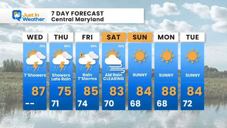
This is currently the hottest summer on record locally. It has now produced 38 days over 90ºF and 8 days over 100ºF for Baltimore. This may be done, at least for a while as cooler weather is in the foreseeable future. Initially this will be with clouds and rain. Then we clear out this weekend and remain pleasant.
Debby is now a Tropical Storm located off the South Carolina coast. It is slowly moving and dumping a once-in-a-1,000-year rainfall of between 20 and 30 inches. This storm will loop back inland tonight and is now expected to pick up speed and move out by the weekend.
For the Mid-Atlantic region, this will bring heavier rain to the mountains and less by the coast. This is often the case with tracks like this, and it may benefit our Maryland Trek Team as we travel through the Eastern Shore to the Ocean City beach on Friday and Saturday.
Summer Hot Day Totals At BWI
8 Days at or above 100ºF
38 Days total at or above 90ºF (23 Days above 95ºF)
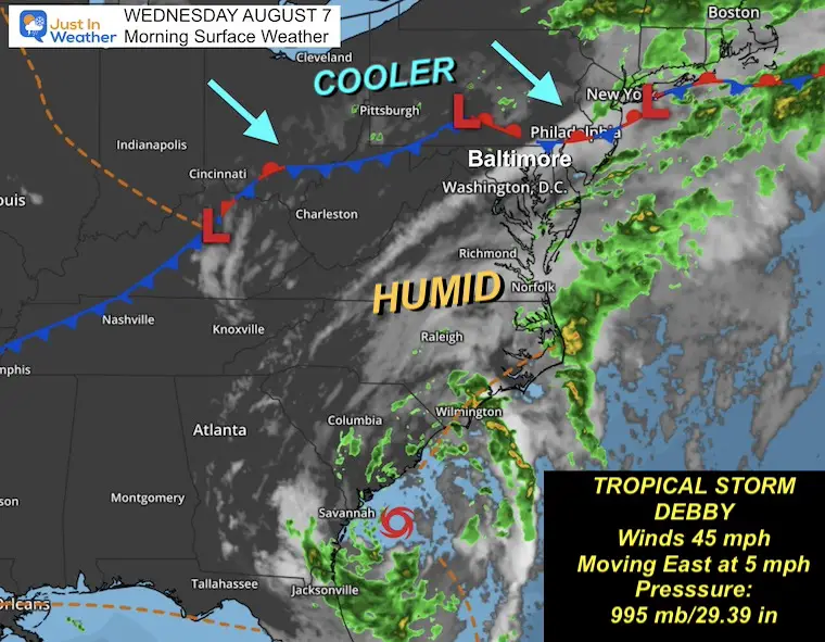
Morning Surface Weather
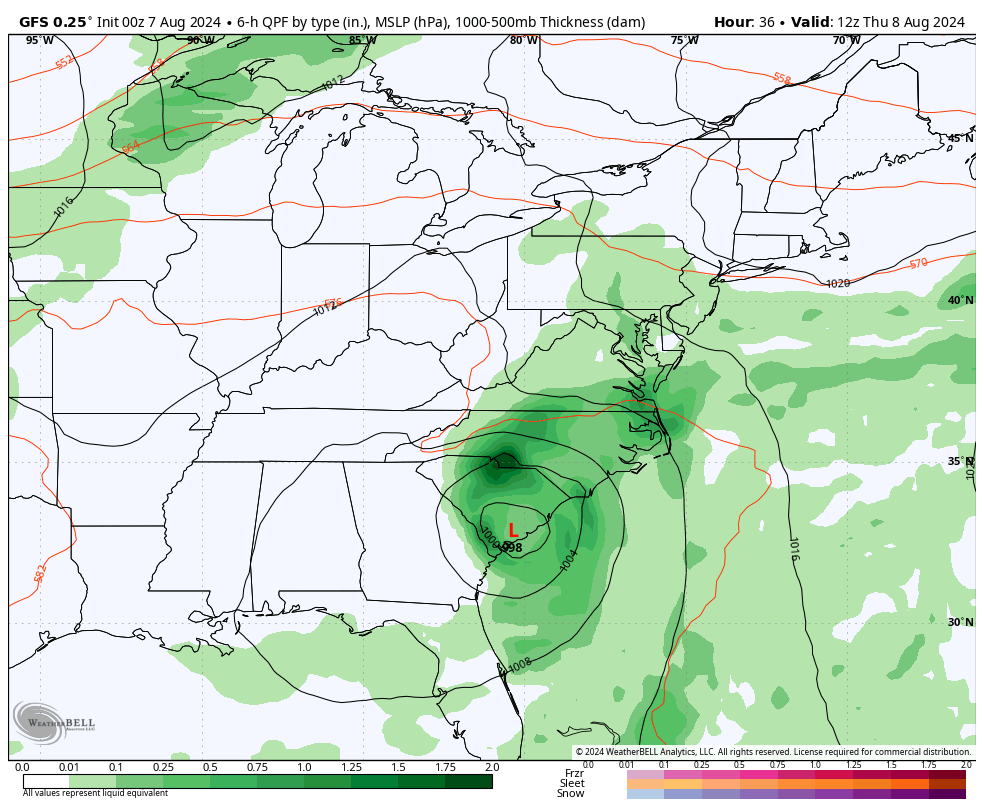
Tropical Storm Debby has winds of 45 mph. The forecast return over the water today will allow this to retain or regain strength. It will also pick up more moisture to dump more rain across the Eastern US. This will all be enhanced by an approaching cold front from the Great Lakes that may stall over the Mid-Atlantic for a few days.
A cold front to our northwest will work together to create ripples or waves in the atmosphere that will produce bands of heavy rain and thunderstorms.
Live Radar Widget
TRACK TIMING
Here in the Mid-Atlantic, our hot days will be replaced by more clouds and storms over the next few days. The rain impact will be spread over a few days, but it may still replace the drought with potential flooding. At best, we will split the weekend and get dry weather late Saturday into Sunday.
This has been personally frustrating for two reasons. Tracking and sharing weather information is my job. This week is also my annual Maryland Trek fundraiser, and our team continues to cross the state hiking and biking to honor kids in their cancer journeys. The exact track does not matter because we will definitely get rain. While we must stay on our mission to reach Ocean City on Saturday, safety for all people on our team and crew is a priority!

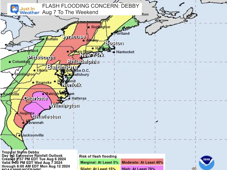
FLASH FLOOD RISK
Tropical downpours may produce rainfall rates of 2 inches per hour.
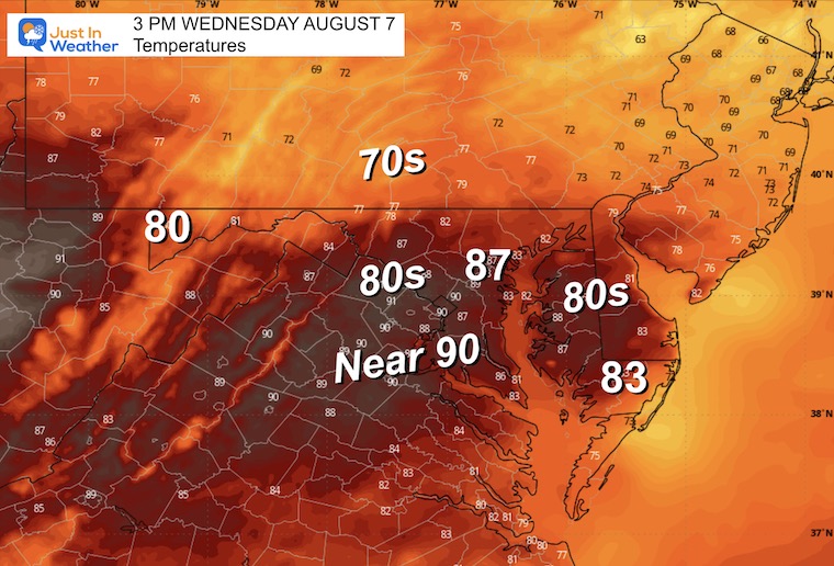
Afternoon Temperatures
Say goodbye to the 90s… More clouds and possible showers will keep us cooler.
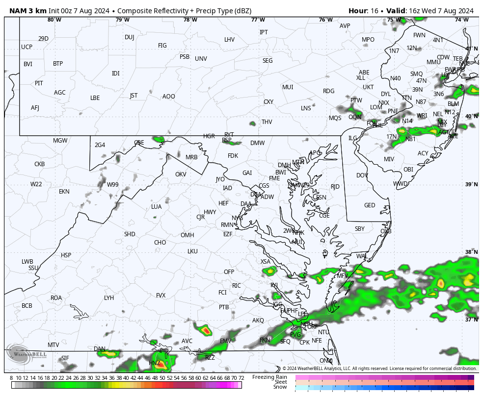
Radar Simulation Animation Noon to Midnight
Maryland Trek 11 Day 3 From Frederick to Elkridge Wednesday for Phoebe.
We begin today with a grand total of OVER $72,000 for Just In Power Kids
The annual event: 329 miles hiking and biking in 7 days between The Summit of Wisp to Ocean City.
Today we honor Phoebe from Frederick through Ellicott City and ending in Elkridge (near BWI). This is our all bike day totaling about 55 miles.
Each day, we honor a kid and their family’s cancer journey.
Fundraising is for Just In Power Kids: Funding Free Holistic Programs. I never have and never will take a penny. It is all for our nonprofit to operate.
Click here or the image to donate


CLIMATE DATA: Baltimore
TODAY August 7
Sunrise at 6:13 AM
Sunset at 8:11 PM
Normal Low in Baltimore: 67ºF
Record 53ºF in 2004
Normal High in Baltimore: 87ºF
Record 105ºF 1918
THANK YOU: Baltimore Sun Magazine Readers Choice Best Of Baltimore
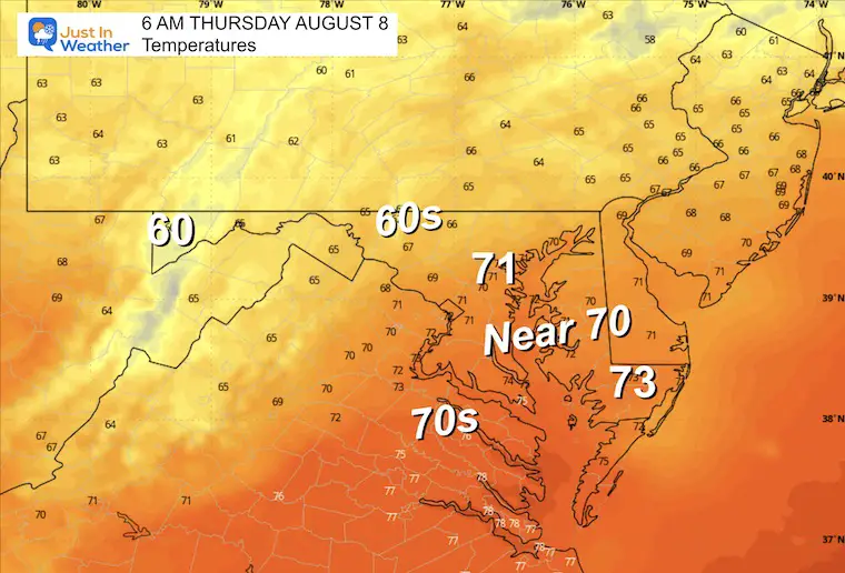
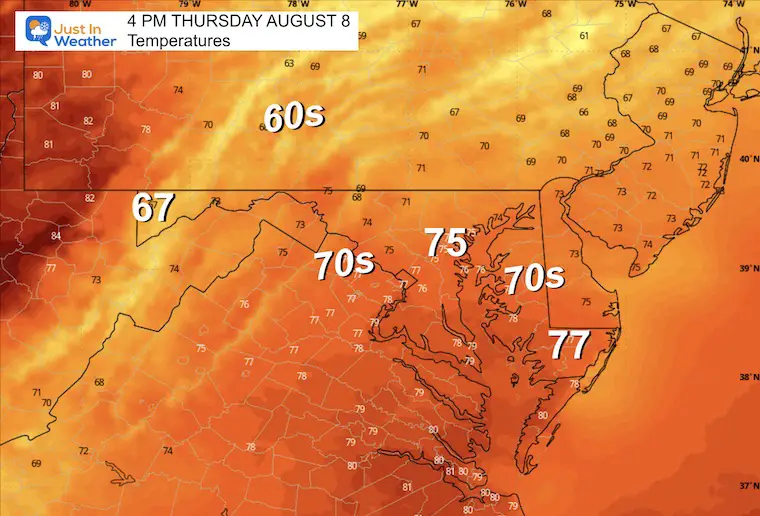
THURSDAY AUGUST 8
There will be a very small spread of temperatures during the day, with clouds, an East wind, and rainfall expected. More showers and thunderstorms are on the cards, especially later in the day and farther inland.
Morning Temperatures
Afternoon Temperatures
Cooler with expected rainfall.
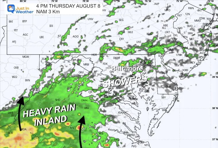
Radar Simulation 8 AM to Midnight
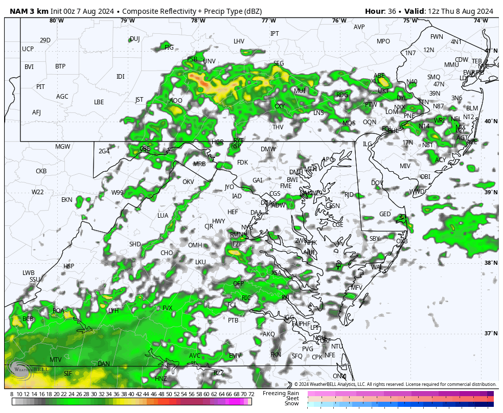
Snapshot at 4 PM
Snapshot at 8 PM
Snapshot Friday Morning
TROPICAL STORM DEBBY
The center of the core Low is off the South Carolina coast and slowly crawling. This is allowing more moisture to get picked up and dumped over the same areas.
Coastal Georgia and South Carolina are getting between 20 to 30 inches of rainfall.
5 AM Stats From The National Hurricane Center
- LOCATION…31.9N 79.5W
- ABOUT 65 MI…105 KM SSE OF CHARLESTON SOUTH CAROLINA
- ABOUT 90 MI…145 KM E OF SAVANNAH GEORGIA
- MAXIMUM SUSTAINED WINDS…45 MPH…75 KM/H
- PRESENT MOVEMENT…E OR 85 DEGREES AT 5 MPH…7 KM/H
- MINIMUM CENTRAL PRESSURE…995 MB…29.39 INCHES
NHC Forecast MAP
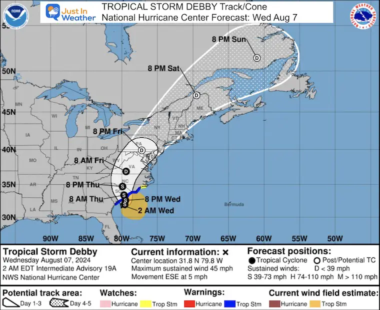
Warnings and Watches
A Storm Surge Watch is in effect for…
* North of South Santee River, South Carolina to Cape Fear, North Carolina
A Tropical Storm Warning is in effect for…
* North of the Savannah River to Surf City, North Carolina
A Tropical Storm Watch is in effect for…
* North of Surf City, North Carolina to Beaufort Inlet, North Carolina
Outlook Notes
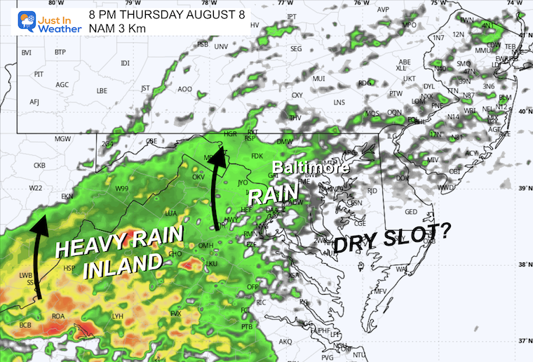
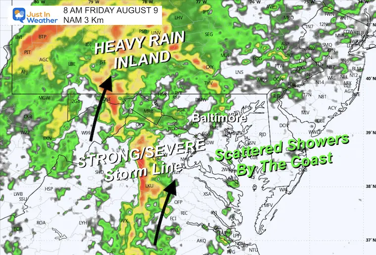
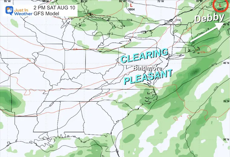
The good news update is Debby’s faster speed once pulled inland. At this point, it may race through Friday and be gone by Saturday. Also, heavier rain is expected inland, with perhaps a dry slot moving in to break up the rain along the coast.
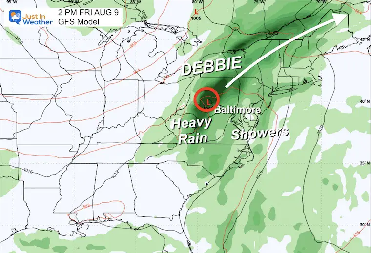
GFS Model: Thursday to Saturday
Heavy rain inland will race through the region and clear out by Saturday.
Snapshots
Friday Afternoon
Saturday Afternoon
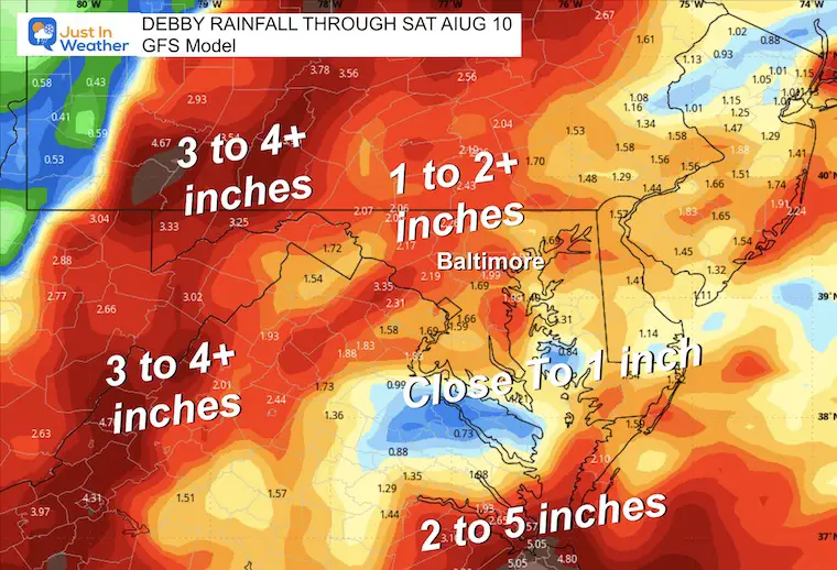
Rainfall Potential
Drought Buster and Flood Potential across the inland mountains. The Shenandoah Mountains have been the most dry this summer and will be the most wet this week.
Often, a dry slot can get pulled in near the coast as a tropical storm moves inland. That may be the case with less rain on Delmarva (and good news for our Maryland Trek 11 team.)
7 Day Forecast
Debby’s impact will last through Friday. A faster forward speed will move it out of the region by the weekend. Very nice weather often follows a tropical system, and we should remain pleasant in the 80s.
Please share your thoughts and best weather pics/videos, or just keep in touch via social media.
RESTATING MY MESSAGE ABOUT DYSLEXIA
I am aware there are some spelling and grammar typos and occasional other glitches. I take responsibility for my mistakes and even the computer glitches I may miss. I have made a few public statements over the years, but if you are new here, you may have missed it: I have dyslexia and found out during my second year at Cornell University. It didn’t stop me from getting my meteorology degree and being the first to get the AMS CBM in the Baltimore/Washington region.
One of my professors told me that I had made it that far without knowing and to not let it be a crutch going forward. That was Mark Wysocki, and he was absolutely correct! I do miss my mistakes in my own proofreading. The autocorrect spell check on my computer sometimes does an injustice to make it worse. I also can make mistakes in forecasting. No one is perfect at predicting the future. All of the maps and information are accurate. The ‘wordy’ stuff can get sticky.
There has been no editor who can check my work while writing and to have it ready to send out in a newsworthy timeline. Barbara Werner is a member of the web team that helps me maintain this site. She has taken it upon herself to edit typos when she is available. That could be AFTER you read this. I accept this and perhaps proves what you read is really from me… It’s part of my charm. #FITF


