Thursday August 29 2019
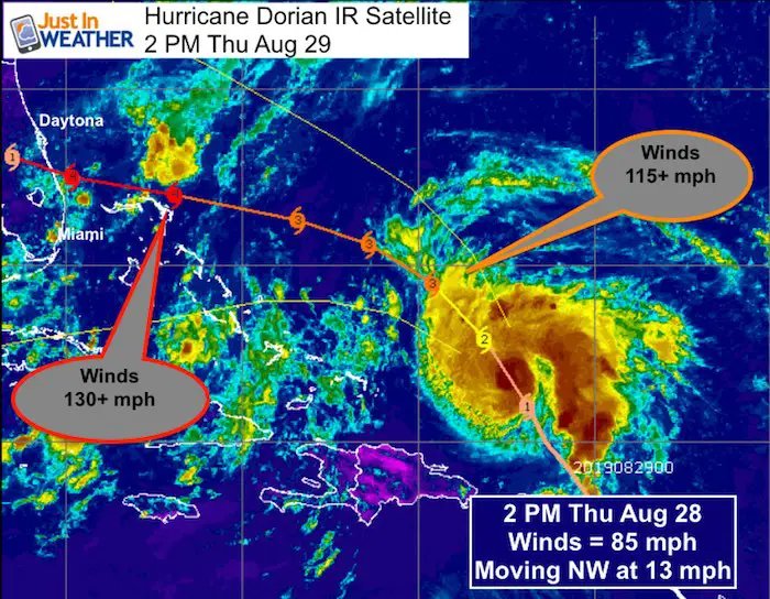
Hurricane Dorian is getting stronger and it looks like it will be a major hurricane as soon as tomorrow. The update on the storm includes the slower movement and track through warmer water which will allow for it to intensity further. The extra time over warmer water adjusted by the latest models puts this as a Category 4 major hurricane with winds of 130 mph or higher when it reaches Florida on Labor Day.
[adrotate group=”4″]
Headlines:
- Will Become A Major Hurricane
- Storm Surge and Winds 115 to 130 mph for Bahamas and Florida
- Landfall delay until Labor Day Monday, but location still too soon to lock in
Hurricane Dorian Satellite Loop
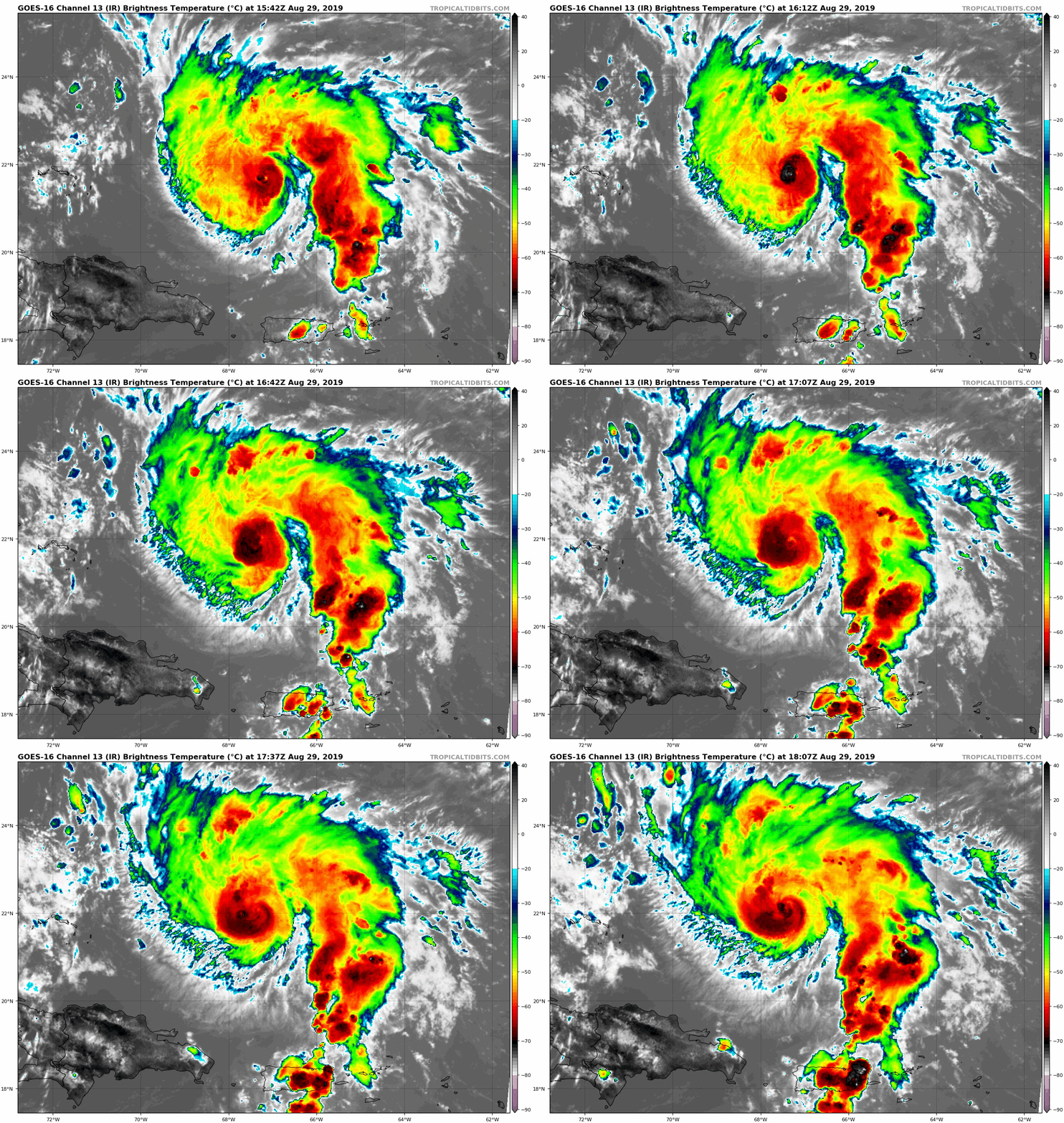
SUMMARY OF 1100 AM AST...1500 UTC...INFORMATION
-----------------------------------------------
LOCATION...21.4N 67.2W
ABOUT 220 MI...355 KM NNW OF SAN JUAN PUERTO RICO
ABOUT 370 MI...600 KM E OF THE SOUTHEASTERN BAHAMAS
MAXIMUM SUSTAINED WINDS...85 MPH...140 KM/H
PRESENT MOVEMENT...NW OR 325 DEGREES AT 13 MPH...20 KM/H
MINIMUM CENTRAL PRESSURE...986 MB...29.12 INCHES

Warnings: NONE at this time

Healthy Storm
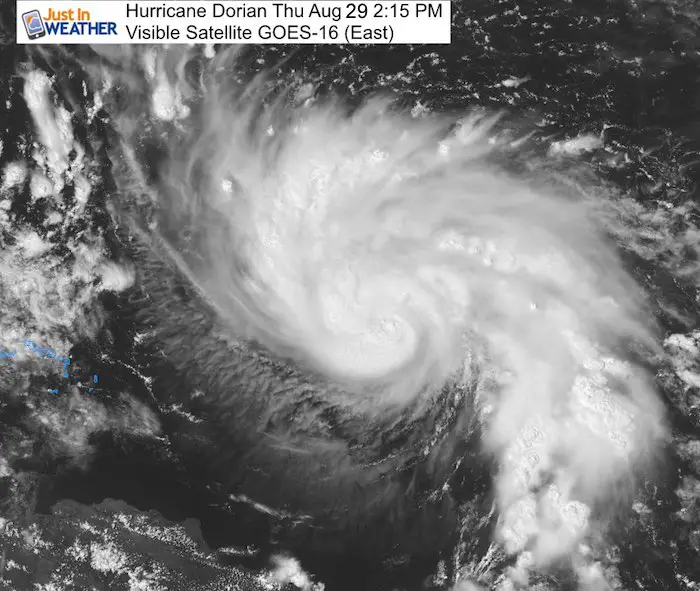
This visible satellite image shows the detail of the outflow cirrus clouds. The high clouds in the center indicate the strong convection around
the eye needed to intensify.
[adrotate group=”4″]
Tracking Over Warmer Water
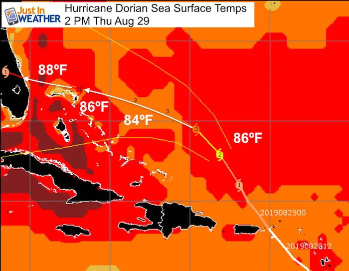
A minimum of 78ºF water temperature is needed for a tropical cyclone to sustain itself. Warmer water helps it grow stronger. Here we see the track over 84ºF water, but closer to the Florida coast it will cross over 88ºF water that will work to fuel the storm further.
 Computer Model Forecasts
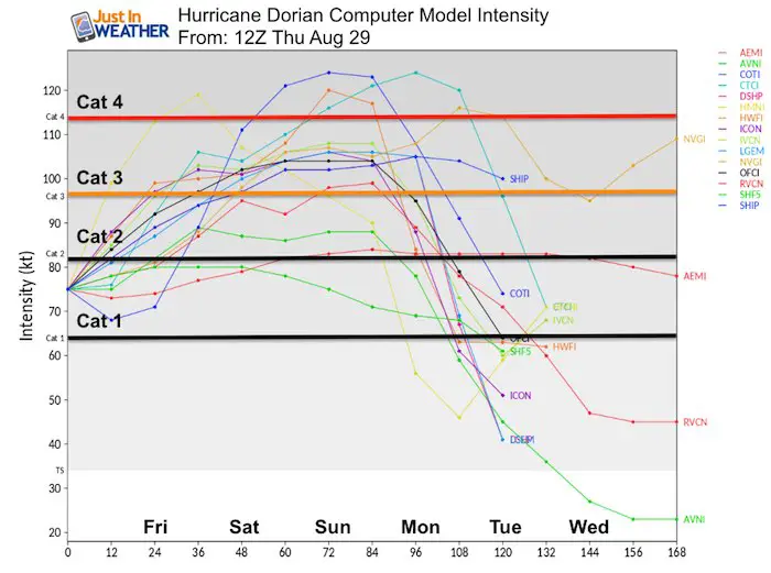
Intensity Forecast: The majority of models calculate Dorian to reach Category 3 by Friday evening. This would be a major hurricane with winds of 115 mph or higher. The guidance points to the potential for further growth to Category 4 over the weekend and before landfall... on
Monday.
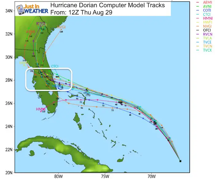
 Computer Guidance Tracks are converging on the central Florida coast. This is still TOO EARLY to pin down and I expect there will be
some room to wiggle depending on the timing and the High Pressure to the north.
[adrotate group=”4″]
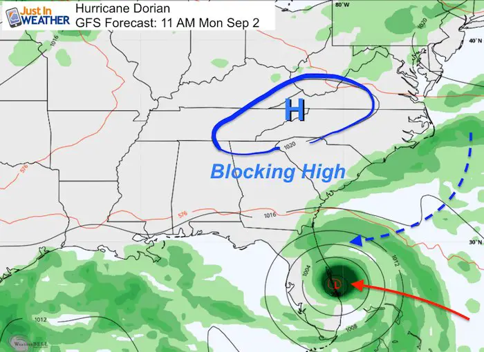
GFS Model
I am showing this model it illustrate the issue for landfall. This is the model that yesterday showed Hurricane Dorian moving northward up to South Carolina. Now it agrees with the Florida solution... based on the location of High Pressure blocking it to the north.
This is one main feature that will help steer or block the storm. Any chance in the timing of this or Dorian will change how they meet up and
interact.
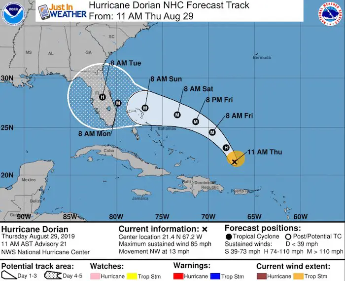
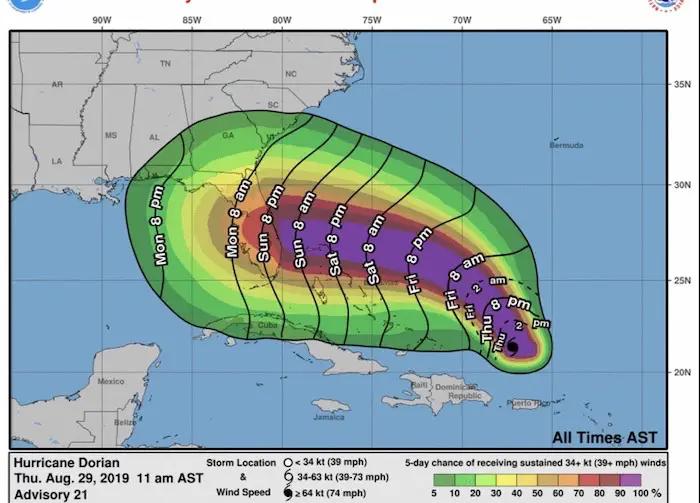
 National Hurricane Center Forecast
 Wind Arrival Time
Winds of 39 mph or higher are expected to arrive the Florida coast during Sunday. The hurricane is plotted for landfall on Monday. So this
will be a large storm and a long duration wind event. some of these winds will be enhanced by the funneling due to High Pressure to the north.
Keep In Touch Every Day
Just in case you don’t get all posts on your social media feed, stay up to date with the latest info…
Click here to sign up for email alerts…. Be the first to hear any new weather
Please share your thoughts, best weather pics/video, or just keep in touch via social media
-
Facebook: Justin Berk, Meteorologist
-
Twitter: @JustinWeather
-
Instagram: justinweather
Thank you to our Title Sponsor for Maryland Trek 6
Shining on with Smyth and their contribution, our team has raised over $95,000 for Just In Power Kids to provide free programs for kids in and post cancer treatment.
Maryland Trek Cycle Jerseys From Hill Killer
All proceeds will go to the Maryland Trek 6 total and Just In Power Kids programs
Just In Power Kids:
Proceeds go to our programs Providing FREE holistic care for kids in cancer treatment and up to 5 years post treatment and caregivers.

Shine On
Proceeds from all sales go to Just In Power Kids. Click the image to shop and show your support.
Love Maryland Shirts and Hoodies
This shirt was designed by my ‘bonus’ daughter Jaiden. The hoodie has been the biggest hit, so our promotion has been extended until the end of this week.
|
||
|
Show your love for Maryland and make this 14 year old artist and her mom extra proud
|
Related Links:


