Wednesday Afternoon, January 21, 2026
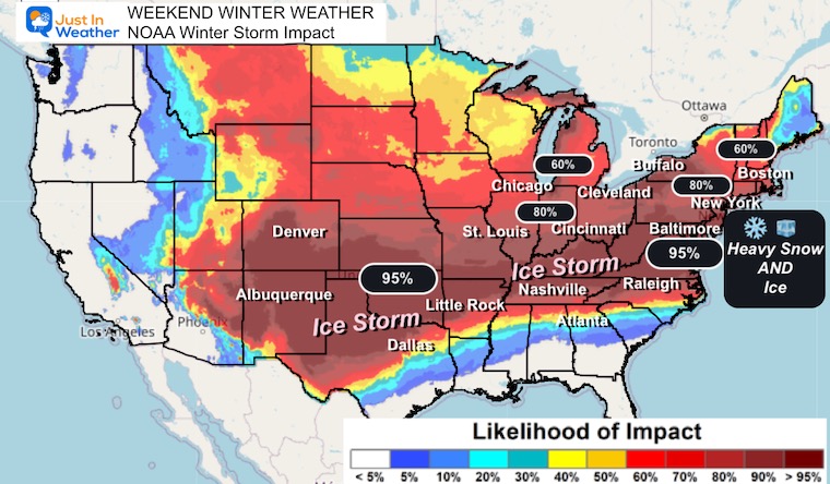
We are expecting a very large winter storm to begin to develop on Friday and stretch across more than two dozen states into the Eastern US on Sunday. A moderate to heavy snow and ice storm will affect more than half of the US population along the path and that includes our region here in the Mid-Atlantic.
The dynamics are so vital that NOAA sent an Air Force Reconnaissance/Hurricane Hunters to the Southwestern US to gather more data. This will boost the computer model forecasting. However, I need to compare all scenarios. In this report, I show a warmer solution that would be the worst-case scenario if you want all snow… because there is a chance there may be ice mixing in if the track lines up the way I show below.
I have High Confidence now for:
- Snow to begin overnight Saturday night. It may show on radar for a few hours before reaching the ground, but that will be while most are sleeping.
- Sunday morning there will be snow to plow and shovel across the region.
- Sunday midday and afternoon: Sleet and freezing rain will mix, but still too early to say precisely what time for you, if at all.
- Temperatures will stay below freezing for the event for almost all, except near the coast.
- Temps will stay below freezing afterwards, complicating clean up.
Low Confidence:
- Where and when the changeover will occur
- Snow totals as a result of potential mixing
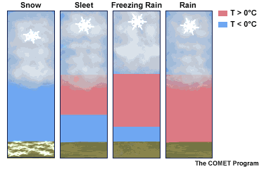
Winter Precipitation
All are a challenge to clean up!
- Frozen precipitation that is not snow is produced when there is a layer of warm air at cloud level or between the clouds and the ground, but surface temperatures are below freezing.
- Sleet is when rain refreezes back to ice pellets.
- Freezing Rain is when the raindrops remain liquid until hitting the ground and then freeze to a layer of ice on contact. Yes, it can be freezing rain with temperatures in the lower 20s IF the warm layer is warm enough and the cold layer is shallow.
This is Why I Don’t Give Snow Totals Too Soon:
The complication I foresee will be mixing ice that will cut into snow totals. Also, help show how we can get ice even with temperatures well below freezing at the surface.
My purpose for this report is to Geek-Out a little and give you some insight under the hood of forecasting. Also, how this is expected to develop on Sunday.
Subscribe for email Alerts
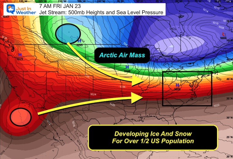
Jet Stream at 500 mb
Phasing of the Northern and Southern branches of the jet stream will allow arctic air to produce a broad area across the nation with snow and ice.
Vorticity at 500mb
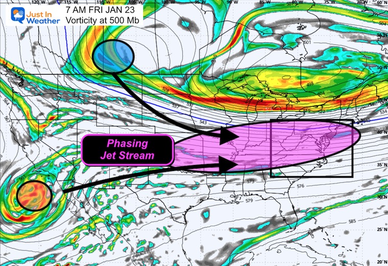
Vorticity Animation Friday to Sunday Night
Storm Animation Wide View: Friday Morning To Sunday Night
Winter Storm Impact
Yes, there are many computer models and new AI models that help us view the storm projection, and if you have seen different forecasts and snow totals, it is because of relying on one model over another.
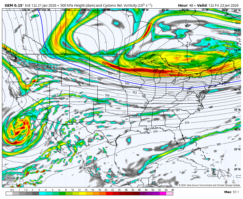
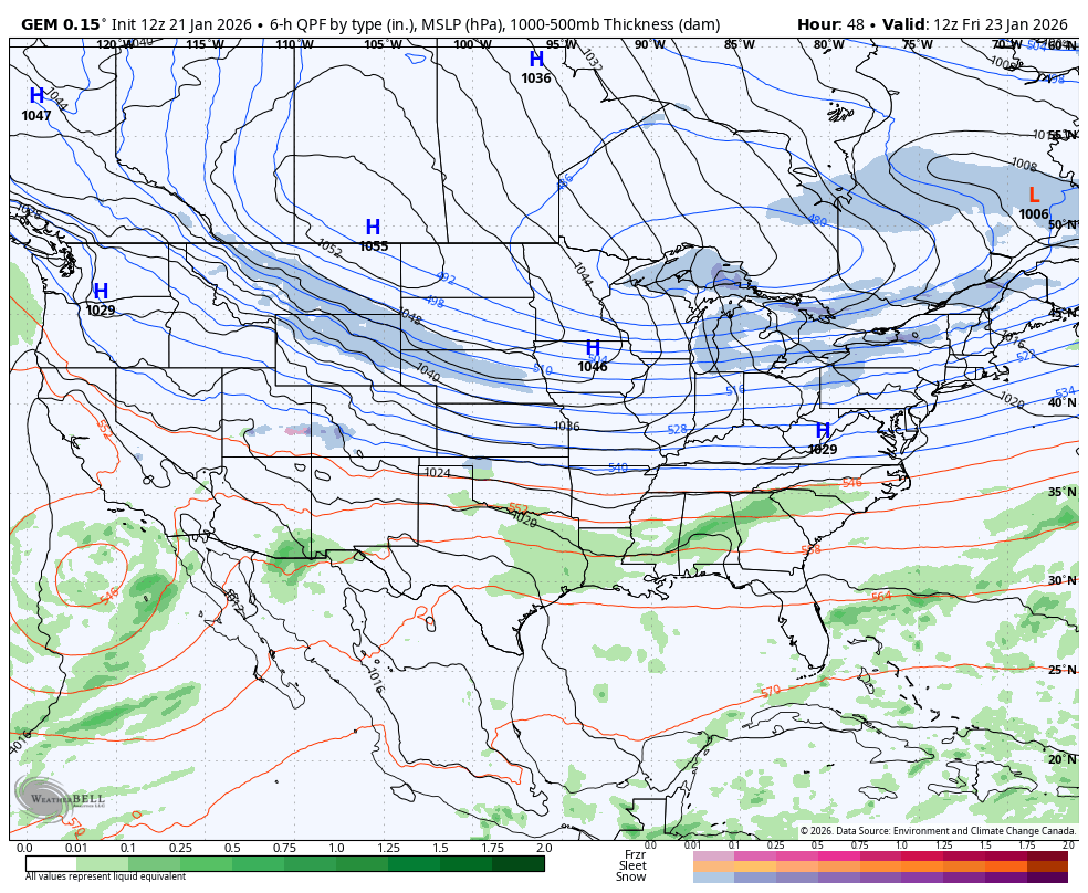
Canadian GEM Model: The Warmer/Mixing Scenario
In my experience, the European Model is the most reliable, but the Canadian GEM performs at its best when there is an arctic air mass that dominates. So, for the sake of this report, I am only using the Canadian GEM Model. It is one of many solutions, but the one that led the way to introduce an icy mix into the Mid-Atlantic and the potential redevelopment of Low Pressure off the coast. This Miller B is a storm type we will discuss below.
Forecast (Eastern US) Friday Night
Cold air will be in place AND it will be dry. My hesitation on the arrival of snow may be delayed due to Virga! That is when snow sublimates and shows on radar at cloud level, but does not reach the ground.
I expect we will see snow beginning between 10 PM Sat to 3 AM Sun.

Forecast Through Monday Morning
Snow will be falling with enough to shovel or plow by daybreak.
Storm Forecast
Closer View: Mid Atlantic
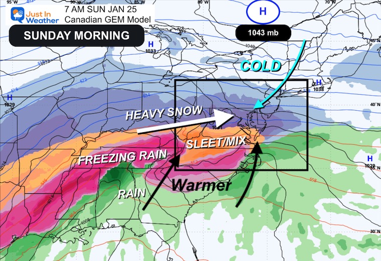
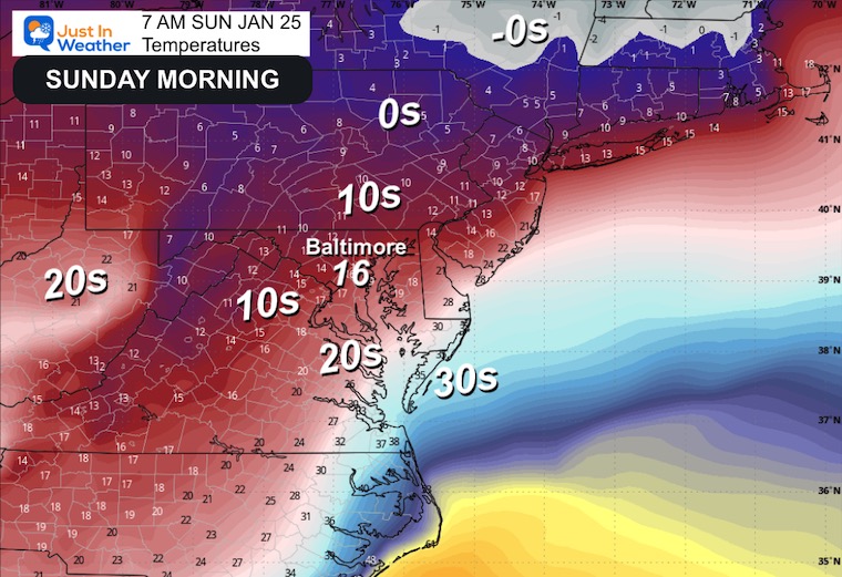
Sunday Morning
Most of the region should wake up to moderate snow.

Temperatures
Most will be in the teens to near 20°F.
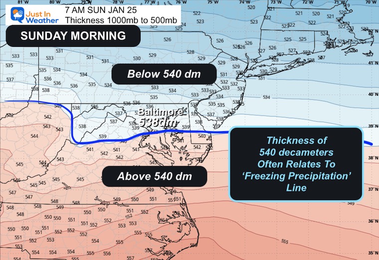
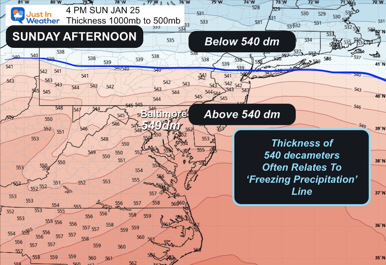
Thickness 1000mb to 500mb
This is a standard measure of the depth of air between these two layers, representing the bottom half of the density of our atmosphere. When colder, it is compact and thinner.
A 540 decameter is a standard for expectations of temperatures near freezing. The result is OFTEN, but not always, frozen precipitation.
Morning Forecast “540 Line” is south of Baltimore, which would be solid snow to the north. The mixing would be in the southern areas where the thickness is higher.
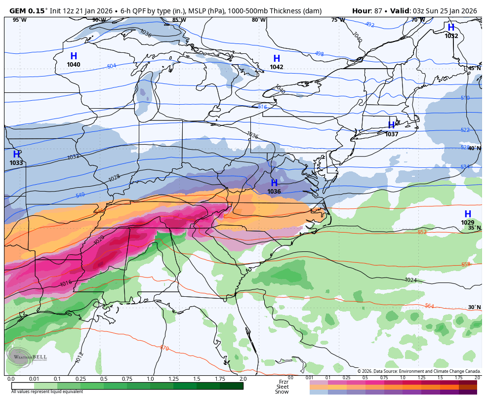
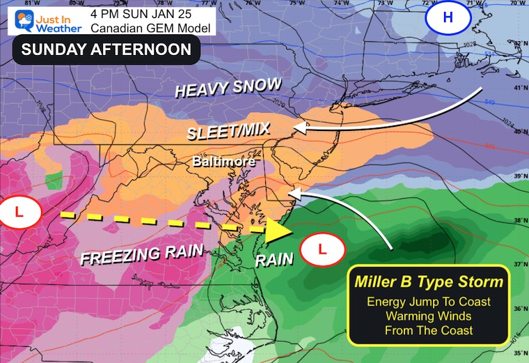
AFTERNOON
Surface Weather
This shows a transition of energy from the Ohio Valley to the coast. This is a Miller-B type storm.
The coastal redevelopment makes this more complicated. It would carry some warmer air aloft AND possibly a dry slot or lull of precipitation in some regions between. Meanwhile, the coastal Low strengthening is a wild card for the shift of all the precipitation and how the temperatures get sorted out.
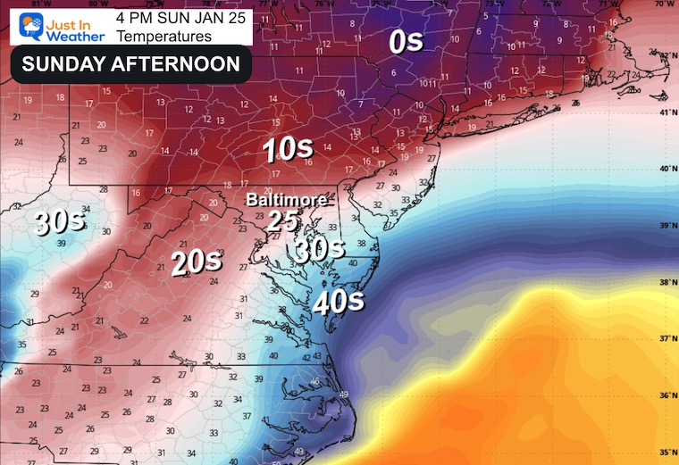
Surface Temperatures
As you can see, Baltimore remains in the mid 20s. Some warmer air on Delmarva, but most inland areas remain well below freezing.
Thickness 1000mb to 500mb
The 540 line shifts well north into Pennsylvania. So this model suggests the sleet and icy precipitation mix moving farther north.
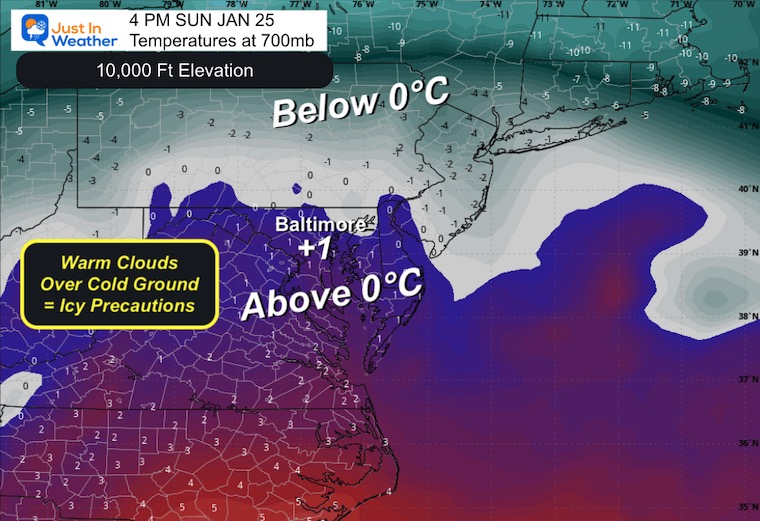
Temperatures at 700mb
This level is roughly 10,000 feet above the ground. It does change height with temperature change.
Here we look for the freezing or 0℃ line as another determination for snow, sleet, or freezing rain falling. If the clouds are warmer, then the precipitation will NOT be snow.
How Much Snow Or Ice?
While there are plots of these from all models in use, I believe there is still uncertainty that makes this unreliable. Often, the numbers on models are overdone!
We can also add in the fact that very cold temperatures can fluff up snow higher, while sleet and freezing rain can be misleading and falsely add to more model totals.
That is why I hold out until 3 days before a storm to give my first call for snowfall. That will be tomorrow, Thursday.
The Winter Storm Watches will likely be issued by the National Weather Service for our region starting Friday, then upgraded to Warnings as we get closer.
The true takeaway: Snow will begin Saturday night. It will be snowing Sunday morning, then may mix with sleet or freezing rain. That is what we see here in the Canadian Model. It is not guaranteed. But even with a mix, most of our region, including the big cities, will remain below freezing and have a lot of ‘stuff’ to carry clean up through
THIS IS WHY I DO NOT SHOW SNOW TOTALS!
I EXPECT the track and timing to adjust as we refine the details. I also tend to believe high numbers early in a forecast tend to trend lower. You may see that along with other fluctuations in your weather apps.
My first suggestion is my best one for now:
Keep the entire weekend on standby! Plan for a large winter storm across 40% of the nation, and we will be on the edge.
There should be enough snow to plow, but ice may creep into southern areas, and northern areas will be on the edge of very dry air.
I want it to snow as well AND I want to get this right for you and a large Mid Atlantic region. This may also be the first of a few storms over the next 2 to 3 weeks.
Faith In The Flakes.
– Justin
Subscribe for email Alerts
FAITH IN THE FLAKES STORE
NOW OPEN FOR THE SEASON
click here

Snow Report December 14 and Grade My Forecast
In case you missed it, click this image for brief summary of the final snow totals from the last event.

Snow Report December 5 to 6 and Grade My Forecast
In case you missed it, click this image for brief summary of the final snow totals from the last event.

My Winter Outlook For Above-Average Snow
Click here for the full report

La Niña Advisory
This was issued October 9, as expected: A weak and short-lived event to start winter may play a different role this winter.

In Case You Missed It
Woolly Bear Caterpillar Winter Folklore
These are NOT all the same caterpillar!

Winter Outlook From 2 Farmers’ Almanacs

STEM Assemblies/In School Fields Trips Are Back
Click to see more and ‘Book’ a visit to your school

THANK YOU:
Baltimore Sun Magazine Readers’ Choice Best Of Baltimore

Maryland Trek 12 Day 7 Completed Sat August 9
UPDATED: We raised OVER $170,000 for Just In Power Kids – AND Still Collecting More
The annual event: Hiking and biking 329 miles in 7 days between The Summit of Wisp to Ocean City.
Each day, we honor a kid and their family’s cancer journey.
Fundraising is for Just In Power Kids: Funding Free Holistic Programs. I never have and never will take a penny. It is all for our nonprofit to operate.
Click here or the image to donate:

RESTATING MY MESSAGE ABOUT DYSLEXIA
I am aware there are some spelling and grammar typos and occasional other glitches. I take responsibility for my mistakes and even the computer glitches I may miss. I have made a few public statements over the years, but if you are new here, you may have missed it: I have dyslexia and found out during my second year at Cornell University. It didn’t stop me from getting my meteorology degree and being the first to get the AMS CBM in the Baltimore/Washington region. One of my professors told me that I had made it that far without knowing and to not let it be a crutch going forward. That was Mark Wysocki, and he was absolutely correct! I do miss my mistakes in my own proofreading. The autocorrect spell check on my computer sometimes does an injustice to make it worse. I can also make mistakes in forecasting. No one is perfect at predicting the future. All of the maps and information are accurate. The ‘wordy’ stuff can get sticky. There has been no editor who can check my work while writing and to have it ready to send out in a newsworthy timeline. Barbara Werner is a member of the web team that helps me maintain this site. She has taken it upon herself to edit typos when she is available. That could be AFTER you read this. I accept this and perhaps proves what you read is really from me… It’s part of my charm. #FITF
Please share your thoughts and best weather pics/videos, or just keep in touch via social media.


