January 19 2026
Monday Evening Update
The weather pattern over North America is aligning with a nearly ideal set up for a large winter storm to form and affect much of the Eastern US this weekend. In fact, there is reason to believe there could be a few storms in the pipeline over the next 2 to 3 weeks. So winter is about to get busy and reminder of some notable winters of the past!
My purpose of this report is to show how this is expected to develop. But in this age of instant gratification, if you are looking for snow totals you will not get them here.
This early stage I suggest keeping the entire weekend (Saturday and Sunday) in mind to allow for some slight changes in the arrival and departure. Also the impact.
I have high confidence that a storm will form. There is a lot of computer model support. However, many variables need to come together and slight variations can change how the storm will behave. It is too early to lock in timing, track, and totals.
I stand by a strategy I have held in over 30 years of forecasting.
No matter how good things may look, predicting snow totals is purely guesswork beyond 3 days ahead of a storm. If you have a moment to take notes on the totals you may have seen online or even your weather app… then go back and keep adding the updates. It is nearly guaranteed they will change. Starting with a high number and trending lower will leave many disappointed or angry. That is why I wait, and focus on the trends to gain my confidence or adjust my expectations.
Let’s take a look:
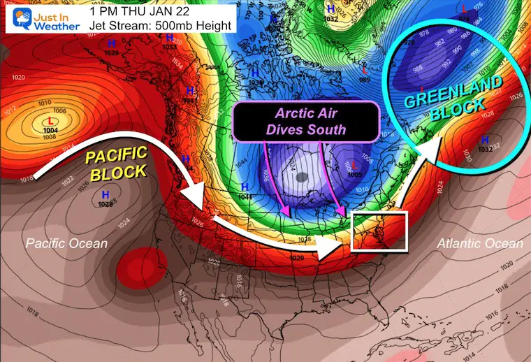
Thursday Afternoon: Nearly Ideal Set Up
Jet Stream at 500 mb
- This is around 18,000 Ft above the ground and a prime focus for the energy at cloud level for influence of storm formation and movement.
- Here we see Blocking on the Pacific Coast with a strong ridge AND North Atlantic/Greenland.
- Arctic Air in Canada will be diving southward in the middle of the North American Continent into the Central US. Near RECORD High Pressure may dive southward across the Northern Plains. The pressure gradient will enhance the dynamics for fast winds and storm expansion.
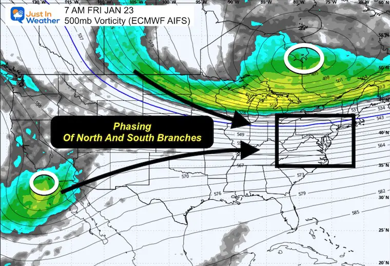
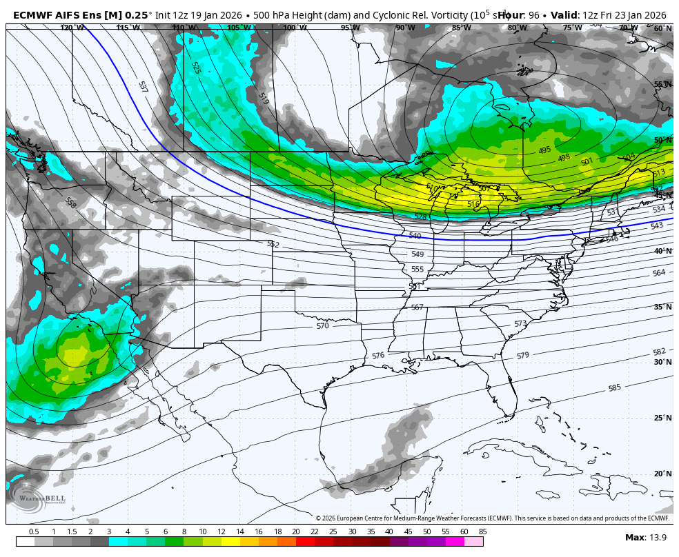
Friday Morning: Focus on Phasing
Jet Stream at 500mb Vorticity
This is the spin in the atmosphere and projected here by the European AI Forecast System. The focus will be strong energy with the leading edge of the Arctic Air moving across The Northern Plains and Great Lakes
AND
The Upper Level Low near Southern California about to eject energy into the Southern US.
These Two Branches will attempt to phase or merge.
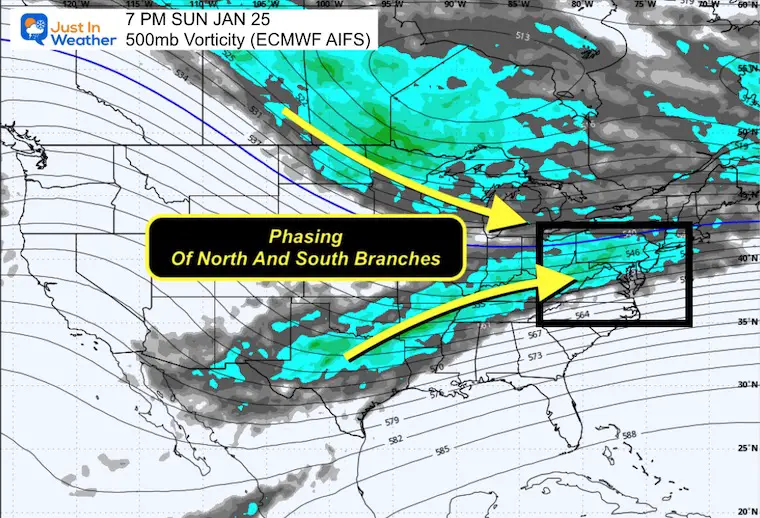
Sunday Night: Phasing Feeding The Storm
This is what is needed for a broad scale longer duration event.
Animation Friday to Sunday
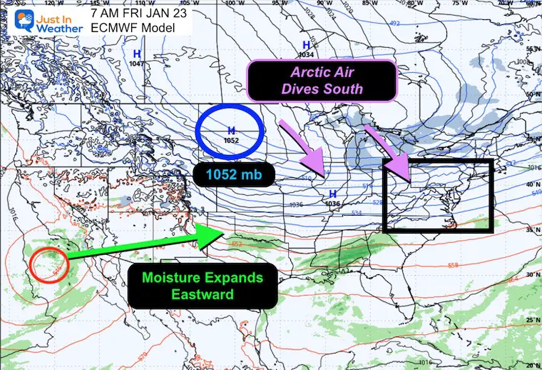
Friday Morning Surface Weather
That 1052mb High Pressure will be near record high across the Dakotas. This will be Very Cold AND Very Dry! That is going to be an important part of this event.
The cold air on the north edge will block the storm and hold the cold. It will also advance at the surface far south while the moist rides above it:
Perfect set up for:
- A Long Duration Event
- An Ice Storm with warm air at cloud level while the surface is below freezing.
Surface Weather Animation Friday to Sunday
This shows the long, stretched development of the storm across the Southern plains to Eastern US.
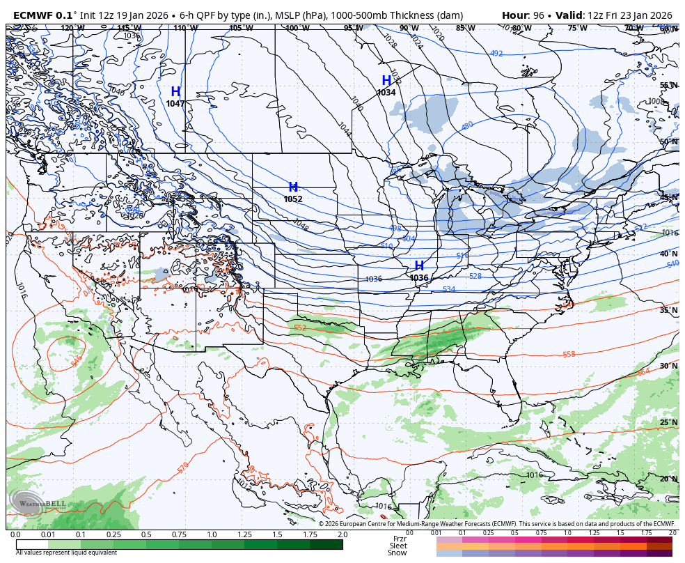
Eastern US View:
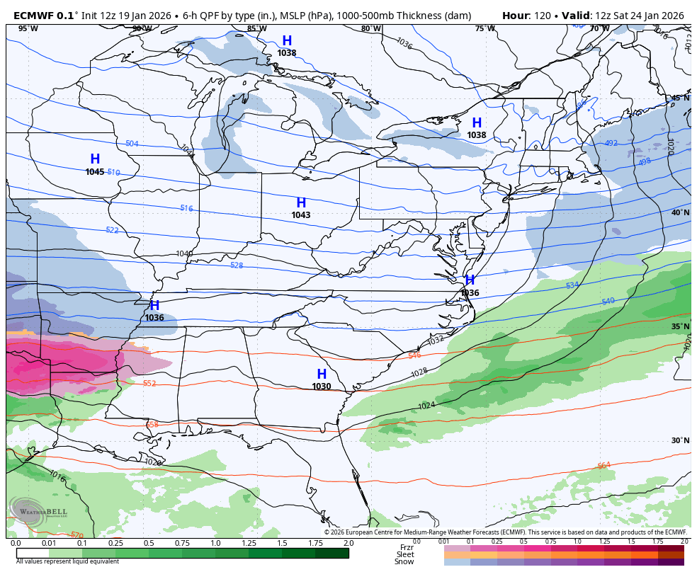
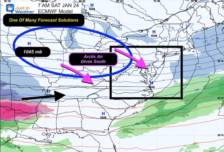
Saturday Morning
High Pressure projected to be 1045mb, still Very Strong.
The location and influence of that will be VITAL to refine as we get closer for the northern extent of snow AND the impact for ice to the South.
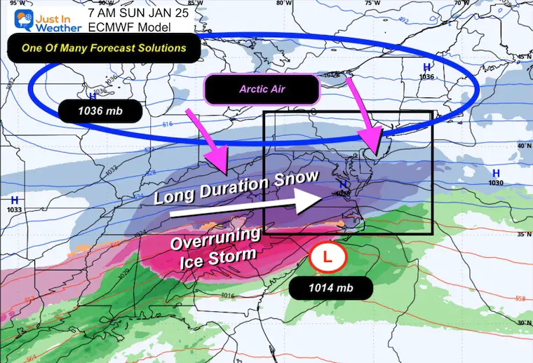
Sunday Morning
This model shows the snow beginning in our region overnight Saturday into Sunday morning.
I need Long Duration Snow for an event that may last longer than 24 hours.
The Overrunning Ice Storm is where the warm clouds and cold ground will produce a large region where heavy freezing rain is possible.
REMINDER: The strength and extent of High Pressure will play a VITAL ROLE in the track of the storm AND northern extent of the moderate snowfall..
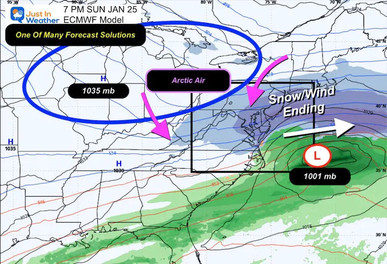
Sunday Night
At this stage, the storm will exit the coast and may strengthen. This is not a very deep Low Pressure, but may enhance the wind and wrap around snow at the very end.
Then there is this:
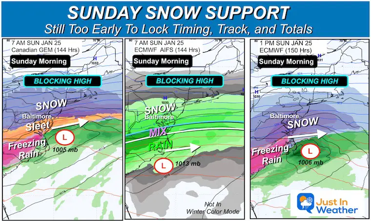
I compiled this comparison that already was different in expectations for track and timing.
The Canadian and AIFS are earlier with impact starting on Saturday, while the ECMWF I have been showing focus the main snow on Sunday.
The Canadian also brings the icy mix much farther north. This may be a factor to consider for parts of our region, while others will be plowing.
NOTES
Computer models are notorious for changing as the various parts come together with different timing, locations, and intensity. THAT is what can change the storm forecast track AND resulting snow.
There is a bias for storms to initially be plotted too far south, then trend north with new runs as the event approaches.
Models are NOT the same. I defer to the European Model often, but really like the Canadian GEM when arctic air is prevalent. Then we introduce the new AI Forecast Systems. As for the GFA, I still do not trust that model and rarely even look at it. So that is out of my display here.
THIS IS WHY I DO NOT SHOW SNOW TOTALS!
I EXPECT the track and timing to adjust as we refine the details.
I also tend to believe high numbers early in a forecast tend to trend lower. You may see that along with other fluctuations in your weather apps.
My first suggestion is my best one for now: Keep the entire weekend on standby!
Plan for a large winter storm across 40% of the nation and we will be on the edge.
There should be enough snow to plow, but ice may creep in southern areas and northern areas will be on the edge of very dry air.
I want it to snow as well AND I want to get this right for you and a large Mid Atlantic region.
This may also be the first of a few storms over the next 2 to 3 weeks.
Faith In The Flakes.
– Justin
Subscribe for email Alerts
FAITH IN THE FLAKES STORE
NOW OPEN FOR THE SEASON
click here

Snow Report December 14 and Grade My Forecast
In case you missed it, click this image for brief summary of the final snow totals from the last event.

Snow Report December 5 to 6 and Grade My Forecast
In case you missed it, click this image for brief summary of the final snow totals from the last event.

My Winter Outlook For Above-Average Snow
Click here for the full report

La Niña Advisory
This was issued October 9, as expected: A weak and short-lived event to start winter may play a different role this winter.

In Case You Missed It
Woolly Bear Caterpillar Winter Folklore
These are NOT all the same caterpillar!

Winter Outlook From 2 Farmers’ Almanacs

STEM Assemblies/In School Fields Trips Are Back
Click to see more and ‘Book’ a visit to your school

THANK YOU:
Baltimore Sun Magazine Readers’ Choice Best Of Baltimore

Maryland Trek 12 Day 7 Completed Sat August 9
UPDATED: We raised OVER $170,000 for Just In Power Kids – AND Still Collecting More
The annual event: Hiking and biking 329 miles in 7 days between The Summit of Wisp to Ocean City.
Each day, we honor a kid and their family’s cancer journey.
Fundraising is for Just In Power Kids: Funding Free Holistic Programs. I never have and never will take a penny. It is all for our nonprofit to operate.
Click here or the image to donate:

RESTATING MY MESSAGE ABOUT DYSLEXIA
I am aware there are some spelling and grammar typos and occasional other glitches. I take responsibility for my mistakes and even the computer glitches I may miss. I have made a few public statements over the years, but if you are new here, you may have missed it: I have dyslexia and found out during my second year at Cornell University. It didn’t stop me from getting my meteorology degree and being the first to get the AMS CBM in the Baltimore/Washington region. One of my professors told me that I had made it that far without knowing and to not let it be a crutch going forward. That was Mark Wysocki, and he was absolutely correct! I do miss my mistakes in my own proofreading. The autocorrect spell check on my computer sometimes does an injustice to make it worse. I can also make mistakes in forecasting. No one is perfect at predicting the future. All of the maps and information are accurate. The ‘wordy’ stuff can get sticky. There has been no editor who can check my work while writing and to have it ready to send out in a newsworthy timeline. Barbara Werner is a member of the web team that helps me maintain this site. She has taken it upon herself to edit typos when she is available. That could be AFTER you read this. I accept this and perhaps proves what you read is really from me… It’s part of my charm. #FITF
Please share your thoughts and best weather pics/videos, or just keep in touch via social media.


