Saturday Evening Update January 17 2026
One thing I carry after all of my years of forecasting: If one model does a really good job in an active pattern, then stick with it. The short range high resolution HRRR Model did just that with our burst of snow this morning, even calling for the 2 to 4 inch totals. However, there was a band in Central Maryland that over achieved its expectations.
The next weather event will come on Sunday in TWO PARTS!
This is important to keep in mind because the first will seem to repeat what we just had. The second will respond the the Southern Storm passing off the coast. I do not see a westward trend of this Low Pressure, but rather the weakness in the atmosphere will allow the moisture to fill back a little farther west/inland.
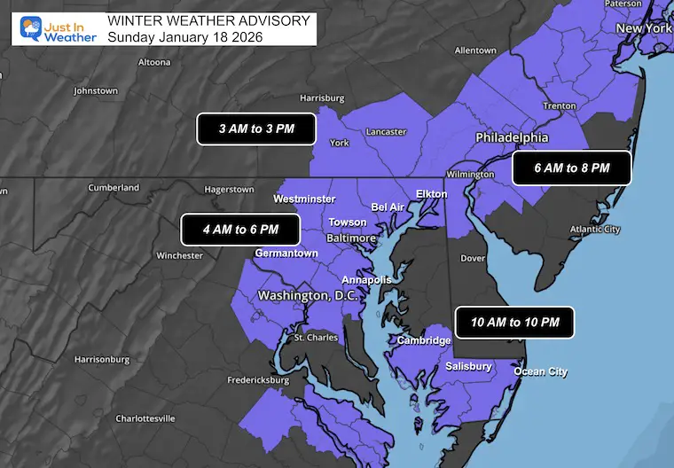
Winter Weather Advisory
Generally potential for 1 to 3 inches of snow with stickage on the roads,
- Southern PA: 3 AM to 3 PM. The Morning Event Focus
- Central Maryland: 4 AM to 6 PM: The Morning Event Focus, may get clipped by Part 2
- afternoon.
- Lower Eastern Shore: 10 AM to 10 PM: The second event is the focus with emphasis on accumulation (light) and icing after dark.
- Metro Philadelphia to Metro New York: 6 AM to 8 PM. May get affected by both parts in the morning and later afternoon.
Here are my headlines:
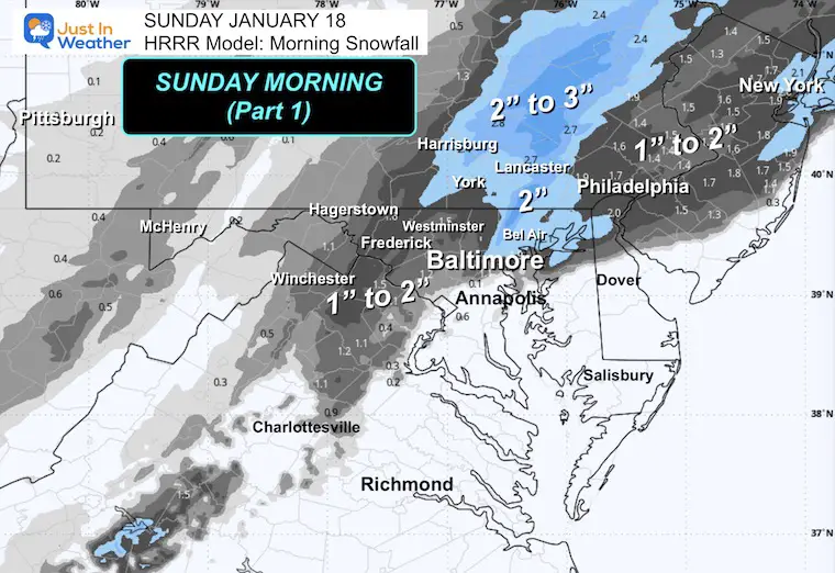
Part 1: Sunday Morning
- Developing 4 to 6 AM, Ending 9 to 11 AM
- Almost the same areas impacted Saturday morning will see a similar result here. Temps will be a little colder, so more may get stickage.
- A slushy mix will reach metro areas again and more rain will fall to the south this time.
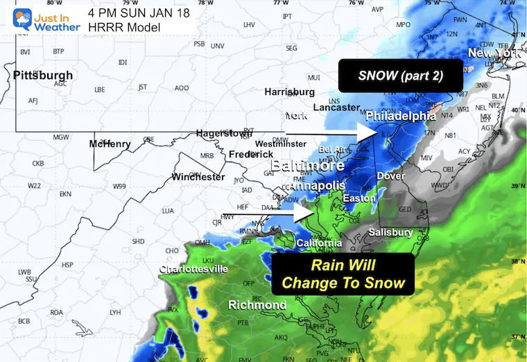
Part 2: Sunday Afternoon and Evening
- The back edge of snow showers will be near I-95 and could include Baltimore and Annapolis. HOWEVER, this will be with afternoon temps above freezing.
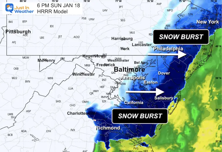
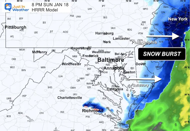
- Heavier snow will develop between 4 PM and 8 PM near The Bay and Delmarva to the Beaches.
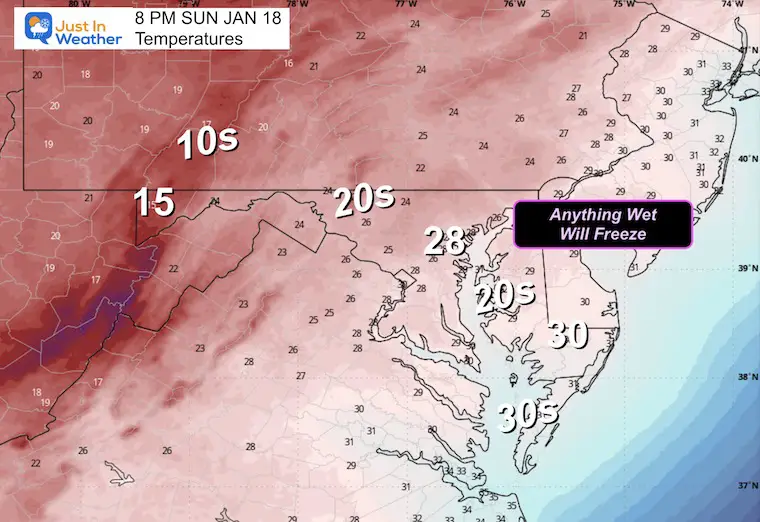
- While temps will start above freezing and may melt or waste flakes… it will end with falling temps after dark.
- Whatever is wet and untreated, will freeze.
- It is a good thing Monday is a holiday, because there will be ice to deal with Monday morning!
SET UP: Evening Surface Weather
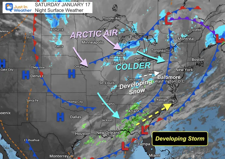
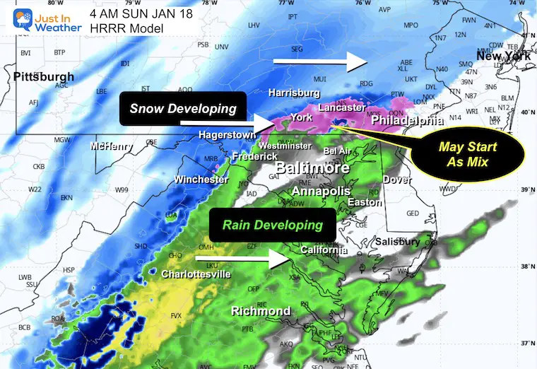
- Developing Snow: A band of snow is developing from the Ohio Valley through the Mid-Atlantic. This will bring snow and mix chances overnight into Sunday morning for parts of Central Maryland and Pennsylvania.
- Developing Storm: The main event is forming along the Gulf Coast from Louisiana through Florida. This storm will track along the coast Sunday and bring snow to North Florida and South Georgia — a rare event! The back edge will clip the Mid-Atlantic, especially Delmarva and coastal areas.
- Arctic Air: Cold air continues to pour south from Canada through the Upper Midwest. This reinforces the cold pattern for early next week.
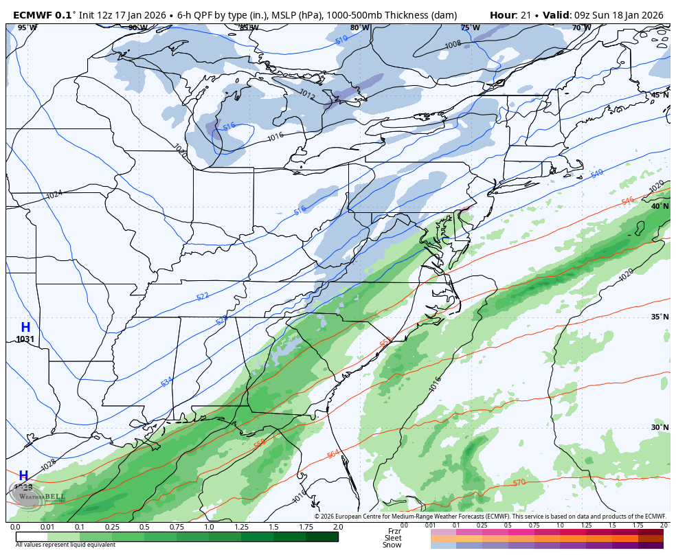
Storm Forecast: ECMWF Model
This may blur the lines between the parts of the snow. A morning phase will be followed by a mid day lull, the resurgence moisture in the afternoon along the coast.
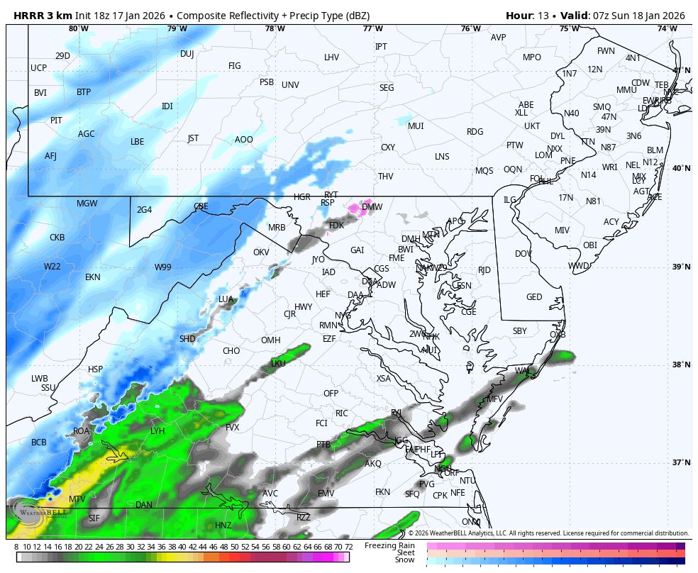
Radar Simulation 3 AM to 8 PM
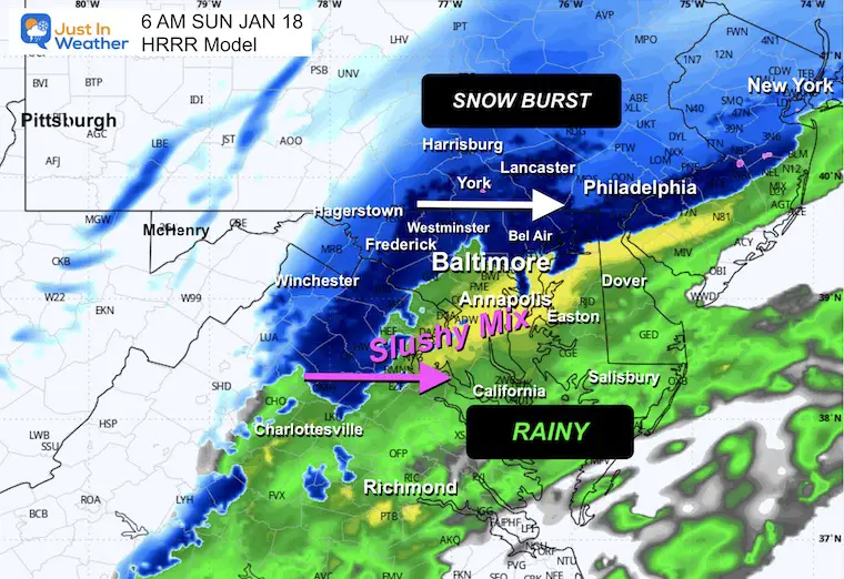
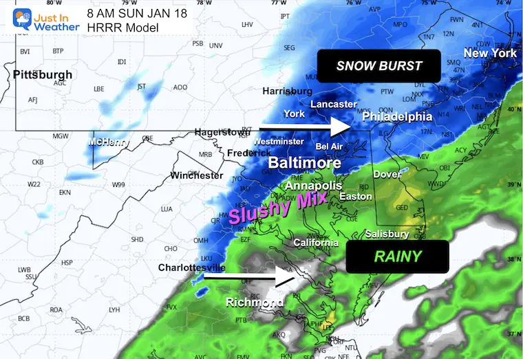
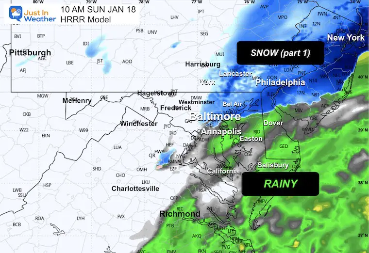
Watch the snow on the HRRR Model expand before sunrise. This will affect Southern Pennsylvania and mountain areas first, and the early hours will coincide with colder temps and allow for more snow and some accumulation.
Snapshots
4 AM
6 AM
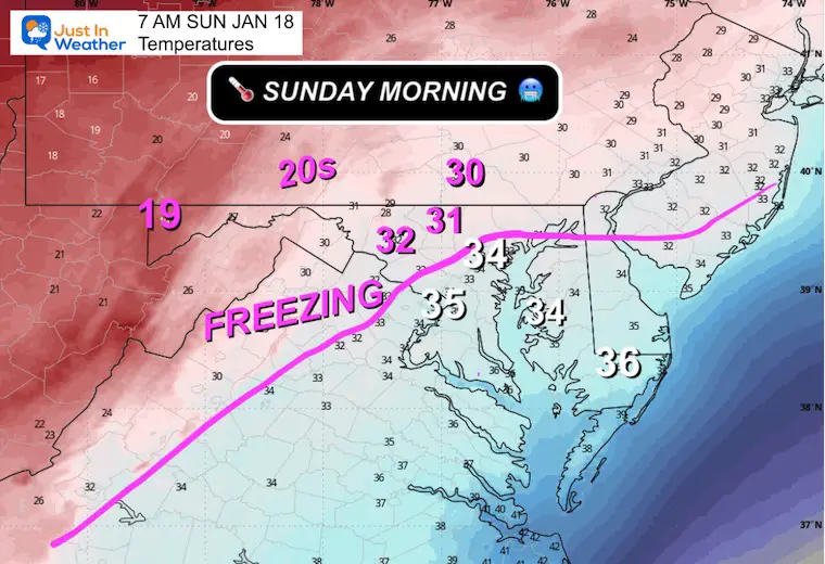
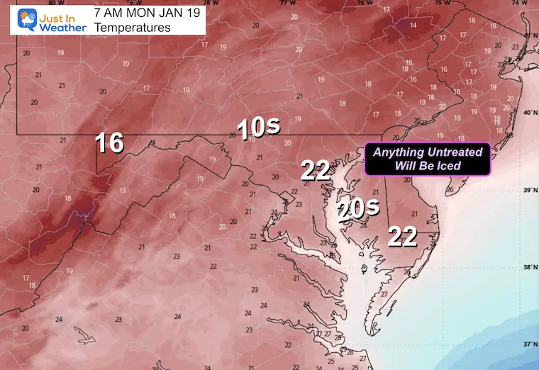
7 AM Temperatures
8 AM
10 AM
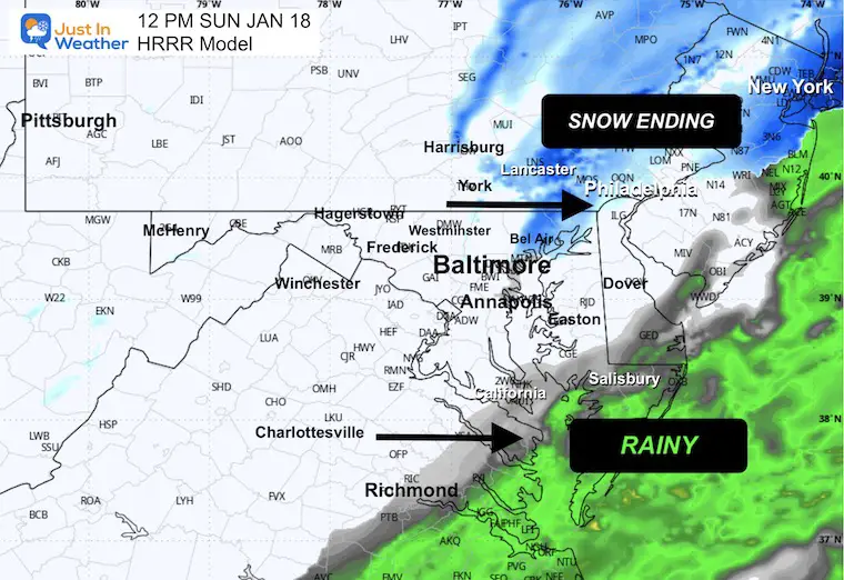
12 PM
Part 1 Snow Forecast HRRR Model
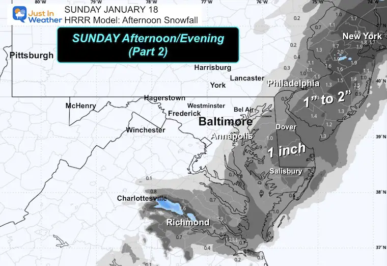
PART 2: Afternoon and Evening
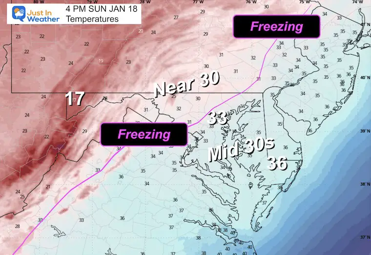
Afternoon Temperatures
This is important for the new snow falling.
4 PM
Heavy slushy snow may be falling between Philadelphia and New York.
6 PM
8 PM
Temperatures
This is when the freeze will affect everyone. What is wet and not treated will turn icy.
Monday Morning Temperatures
Part 2 Snow Forecast HRRR Model
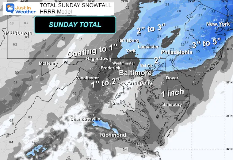
SNOW TOTAL HRRR Model
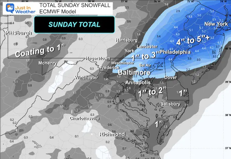
ECMWF Model
This is most aggressive near Metro Philadelphia to New York.
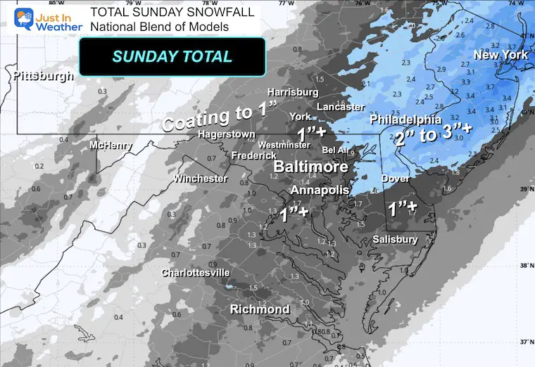
National Blend of Models
Subscribe for email Alerts
FAITH IN THE FLAKES STORE
NOW OPEN FOR THE SEASON
click here

Snow Report December 14 and Grade My Forecast
In case you missed it, click this image for brief summary of the final snow totals from the last event.

Snow Report December 5 to 6 and Grade My Forecast
In case you missed it, click this image for brief summary of the final snow totals from the last event.

My Winter Outlook For Above-Average Snow
Click here for the full report

La Niña Advisory
This was issued October 9, as expected: A weak and short-lived event to start winter may play a different role this winter.

In Case You Missed It
Woolly Bear Caterpillar Winter Folklore
These are NOT all the same caterpillar!

Winter Outlook From 2 Farmers’ Almanacs

STEM Assemblies/In School Fields Trips Are Back
Click to see more and ‘Book’ a visit to your school

THANK YOU:
Baltimore Sun Magazine Readers’ Choice Best Of Baltimore

Maryland Trek 12 Day 7 Completed Sat August 9
UPDATED: We raised OVER $170,000 for Just In Power Kids – AND Still Collecting More
The annual event: Hiking and biking 329 miles in 7 days between The Summit of Wisp to Ocean City.
Each day, we honor a kid and their family’s cancer journey.
Fundraising is for Just In Power Kids: Funding Free Holistic Programs. I never have and never will take a penny. It is all for our nonprofit to operate.
Click here or the image to donate:

RESTATING MY MESSAGE ABOUT DYSLEXIA
I am aware there are some spelling and grammar typos and occasional other glitches. I take responsibility for my mistakes and even the computer glitches I may miss. I have made a few public statements over the years, but if you are new here, you may have missed it: I have dyslexia and found out during my second year at Cornell University. It didn’t stop me from getting my meteorology degree and being the first to get the AMS CBM in the Baltimore/Washington region. One of my professors told me that I had made it that far without knowing and to not let it be a crutch going forward. That was Mark Wysocki, and he was absolutely correct! I do miss my mistakes in my own proofreading. The autocorrect spell check on my computer sometimes does an injustice to make it worse. I can also make mistakes in forecasting. No one is perfect at predicting the future. All of the maps and information are accurate. The ‘wordy’ stuff can get sticky. There has been no editor who can check my work while writing and to have it ready to send out in a newsworthy timeline. Barbara Werner is a member of the web team that helps me maintain this site. She has taken it upon herself to edit typos when she is available. That could be AFTER you read this. I accept this and perhaps proves what you read is really from me… It’s part of my charm. #FITF
Please share your thoughts and best weather pics/videos, or just keep in touch via social media.


